| NWS forecast for any "City, St" or Zipcode | |
Current Conditions
Forecasts
Satellite Imagery
Radar Imagery
Winter Wx
Fire Weather
Long Range Outlooks
Other
Kentucky Climate
Climatology
Pests/Disease
Ag/Wx Calculators
Hydrology Info.
Other UKAWC Sites
Severe Wx
Tropical Wx
Kentucky Ag Wx
Drought
National Wx
International Wx
Learning About Wx
About UKAWC
Sun, Moon & Planets UKAWC Home
 |
Weather Forecasts |
Home| Current Conditions| Forecasts| Satellite| Radar| Media| Outlooks| Drought| Severe| Tropical Wx| Winter Wx| Climatology| Calc| Fire| NWS| Historical| About Us| Spring & Fall Ag-Update| Glance| GlanceClim
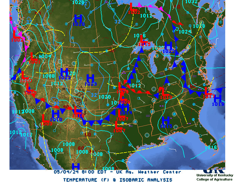
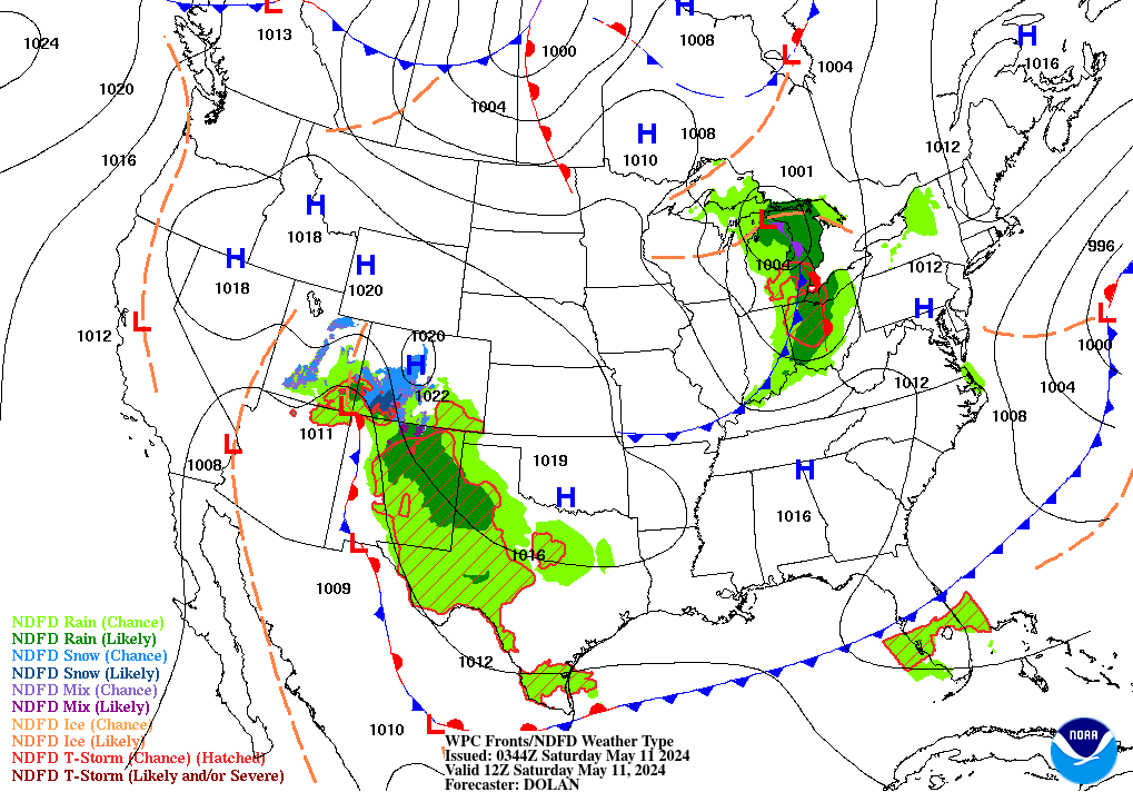
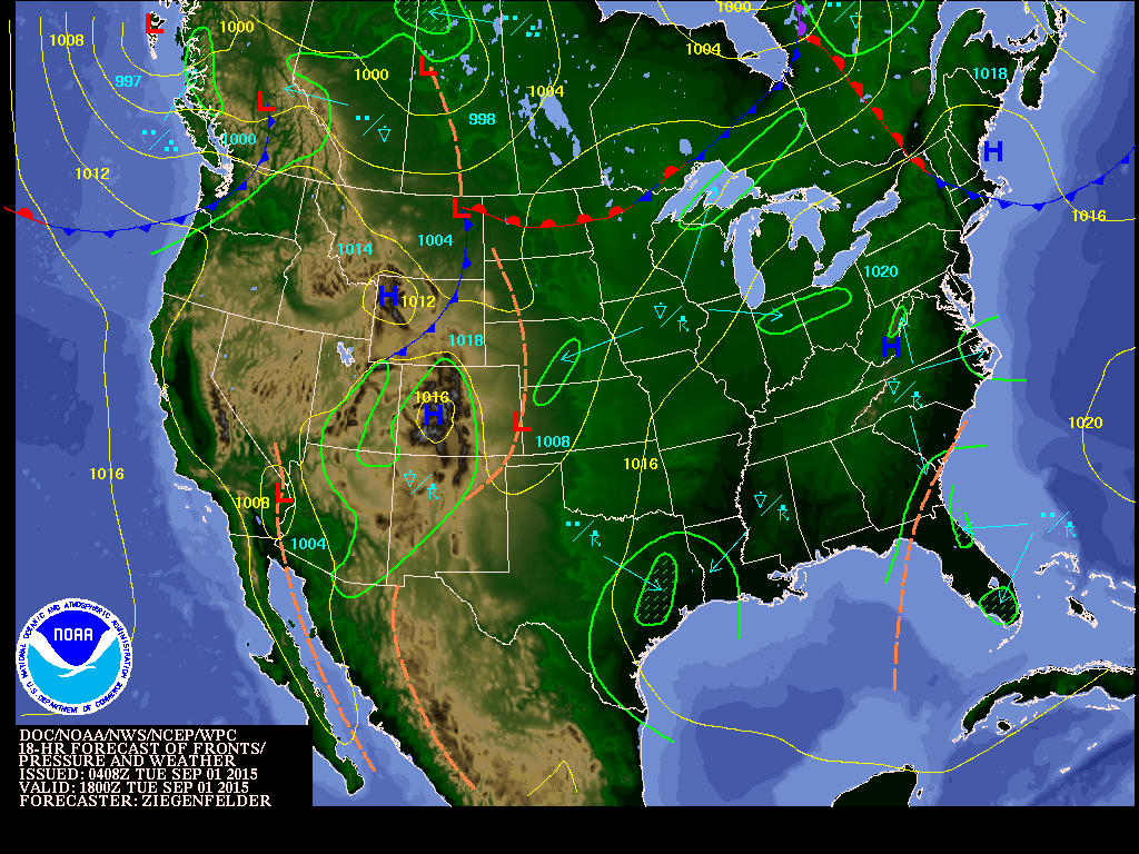
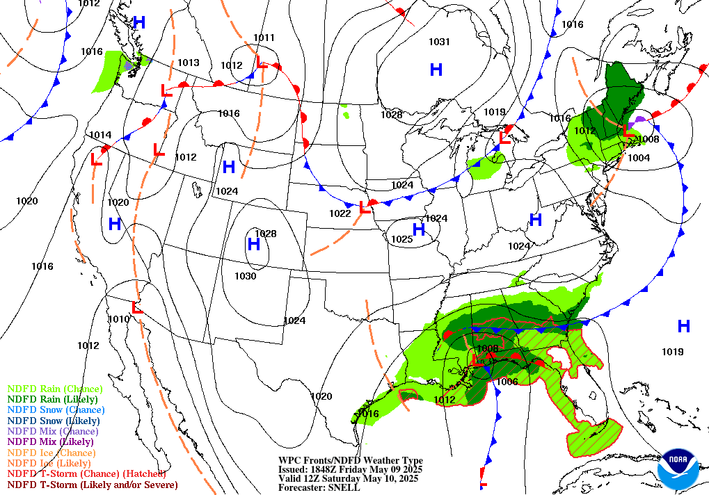
| Surface |
|
NWS Text Forecasts |
Upper Air |
Meteograms/Cross Sections
Precipitation | Guidance |
| WRF Surface Pressure Forecast | Loop | 12 hr | 24 hr | 36 hr | 48 hr |
| WRF Precipitation Forecast | Loop | 12 hr | 24 hr | 36 hr | 48 hr |

| Now | 12 Hr | 18 Hr | 24 Hr | 30 Hr | 36 Hr | 48 Hr | Day 3 | Day 4 | Day 5 | Day 6 | Day 7 | 7 Day Loop | All |
| Now | B/W | B/W | B/W | B/W | B/W | B/W | B/W | B/W | B/W | B/W | B/W | 7 Day Loop | All |
| MAX Temps | Day 3 | Day 4 | Day 5 | Day 6 | Day 7 | All |
| MIN Temps | Day 3 | Day 4 | Day 5 | Day 6 | Day 7 | All |
| BWG | LOU | CVG | FTK | FFT | HOP | EHR | JKL | LEX | LOZ | SDF | PAH | SME | All | HPC |
| 0-48 Hr | 3-5 Day | 6-10 Day | 30 Day | Model Diagnostics | Bias | Excessive Rain Outlook | Heavy Snow Outlook |
| Precip Amts. | Day 1 | Day 2 | Day 1-2 Tot. | Day 3 | Day 1-3 Tot. | 5 Day Total:0Z 12Z | Loop | Browers | All |
| NWS Text Forecasts |
|
Surface | Upper Air | Meteograms/Cross Sections
Precipitation | Guidance |
| Weather Summaries | Western, 2, 3 | Central, 2, 3 | Eastern, 2, 3 | North | Northeast | All, 2 |
| Weather Discussions | Western, 2 | Central, 2 | Eastern, 2 | North, 2 | Northeast, 2 | All, 2 |
| Zone Forecasts | Western, 2, 3 | Central, 2, 3 | Eastern, 2 3 | North, 2 | Northeast, 2 | All, 2 |
| Area Forecast Matrix | Western, 2, 3, NP .AFM | Central, 2, 3 NP .AFM | Eastern, 2 , 3 NP .AFM | North, 2, 3 NP .AFM | Northeast, 2, 3 NP .AFM | All, SR All |
| Kentucky Fire Weather (NWS) | Western, 2 | Central, 2 | Eastern, 2 | North, 2 | Northeast, 2 | All, 2 |
| Kentucky Hazardous Weather Outlooks | Western, 2 | Central, 2 | Eastern, 2 | North, 2 | Northeast, 2 | All |
| Short Term Forecasts (Nowcasts) | Western, 2 | Central, 2 | Eastern, 2 | North, 2 | Northeast, 2 | All |
| Hourly Obs. | [KY], [2], [All] | [IN] | [WV] | [OH] | [TN] | [IL] | [MO] | [AR] |
| County Forecasts | [KY] | [IN] | [WV] | [OH] | [TN] | [IL] | [MO] | [AR] |
| State Forecasts | [KY], All | [IN] | [WV] | [OH] | [TN] | [IL] | [MO] | [AR] | Daily Climate Data | [PAH], [SDF], [LEX], [CVG], [JKL], 1st-order, [ALL] | [IN] | [WV] | [OH] | [TN], 2nd | [IL] | [MO] | [AR] |
| Monthly Climate Data | [PAH], [BWG], [SDF], [LEX], [CVG], [JKL], [ALL] | [IN] | [WV] | [OH] | [TN] | [IL] | [MO] | [AR] |
| Ag. Obs. | [KY], 2nd, [Archive of Evening Obs] | [IN] | [WV] | [OH] | [TN] | [IL] | [MO] | [AR] |
| Upper Air |
|
Surface | NWS Text Forecasts | Meteograms/Cross Sections
Precipitation | Guidance |
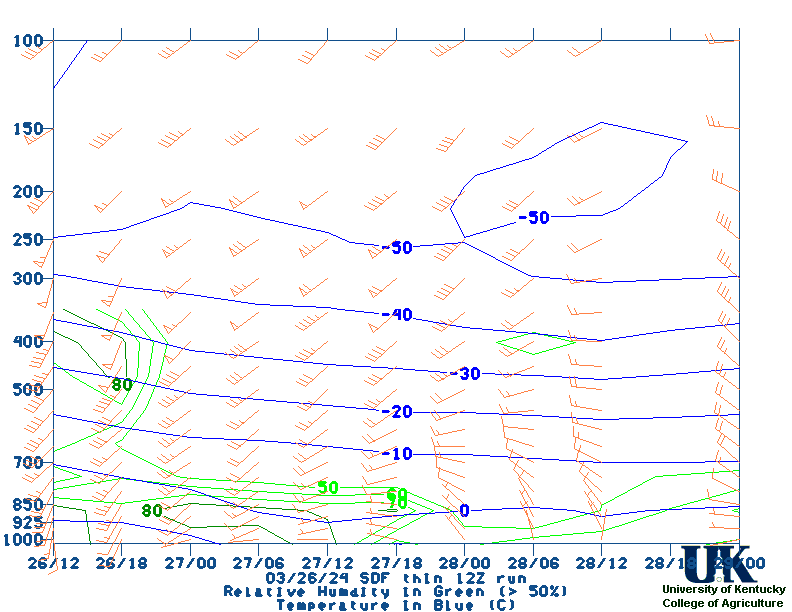
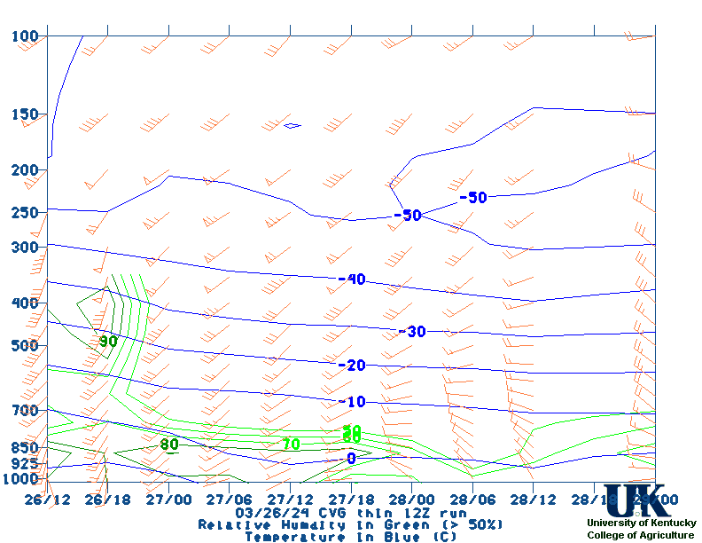
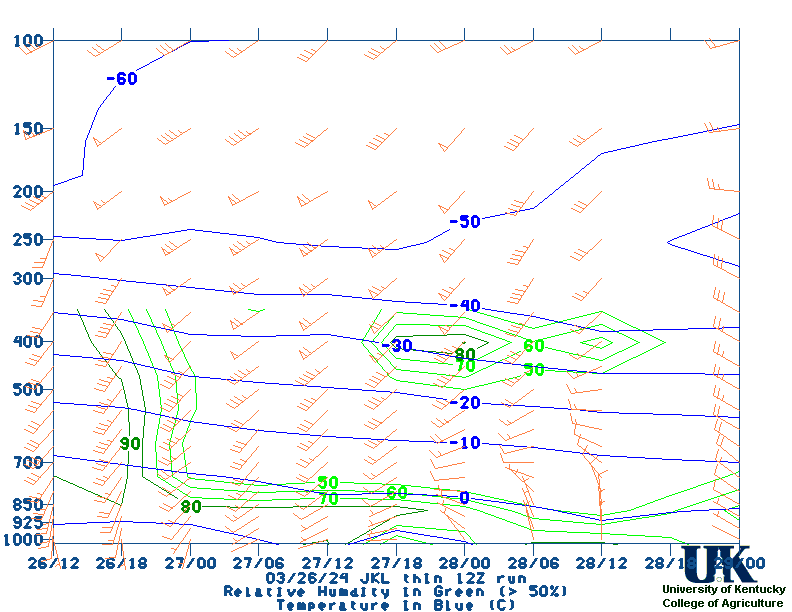
| Meteograms/Cross Sections |
|
Surface | NWS Text Forecasts | Upper Air
Precipitation | Guidance |
|
Forecast Meteograms |
|
|
8 Day Forecast |
Lexington
Louisville Evansville Covington Hopkinsville Somerset London Jackson Paducah Nashville |
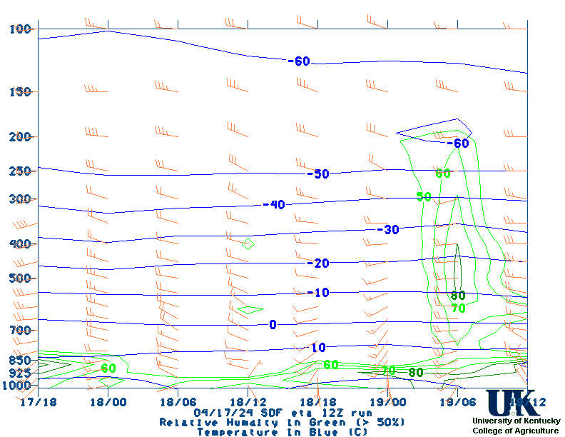
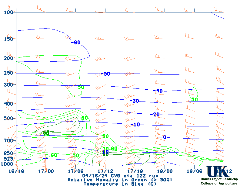
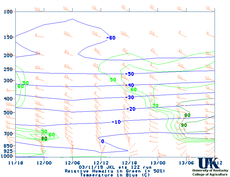
| ETA (12z & 00z) | Paducah | Louisville | Lexington | Covington | Jackson |
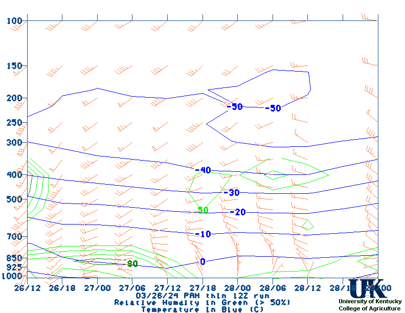
| AVN-thin (06z, 12z, 18z & 00z) | Paducah | Louisville | Lexington | Covington | Jackson |
 UKAWC Stability Indices:
| Lifted Index(LI), 2 | CAPE , 2 | K-Index, 2 | CIN | Showalter Index | SWEAT | Total-Totals, 2 | Descriptions |
| Precipitation |
|
Surface | NWS Text Forecasts | Upper Air
Meteograms/Cross Sections | Guidance |
| HPC Quantitative Precip Forecasts (QPF) | |||
|---|---|---|---|
| 24 Hour Precip Amts. | Heavy Snow | Interactive | |
| Guidance |
|
Surface | NWS Text Forecasts | Upper Air
Meteograms/Cross Sections | Precipitation |
| Kentucky | GFS MOS | NAM MOS | GFSX MOS | ||
| Indiana | GFS MOS | NAM MOS | GFSX MOS | ||
| Illinois | GFS MOS | NAM MOS | GFSX MOS | ||
| Ohio | GFS MOS | NAM MOS | GFSX MOS | ||
| West Virginia | GFS MOS | NAM MOS | GFSX MOS | ||
| Virginia | GFS MOS | NAM MOS | GFSX MOS | ||
| Tennessee | GFS MOS | NAM MOS | GFSX MOS | ||
| Missouri | GFS MOS | NAM MOS | GFSX MOS | ||
| MOS All Stations/Models | Hi-Res Gridded GFS-MOS QPF Images (Exper.) |
||||
| BWG | LOU | CVG | FTK | FFT | HOP | EHR | JKL | LEX | LOZ | SDF | PAH | SME | All |
.