...The mission of the UK Agricultural Weather Program/Center is to provide
educational resources through the development of agricultural weather products
and services that minimize weather surprise to Kentucky residents relative to
their agricultural needs...
Detailed forecast information is available in your Precision Ag Weather
forecast here...
-=-=-=-=-=-=-=--=-=-=-=-=-=-=-=-
Long-range outlooks here.
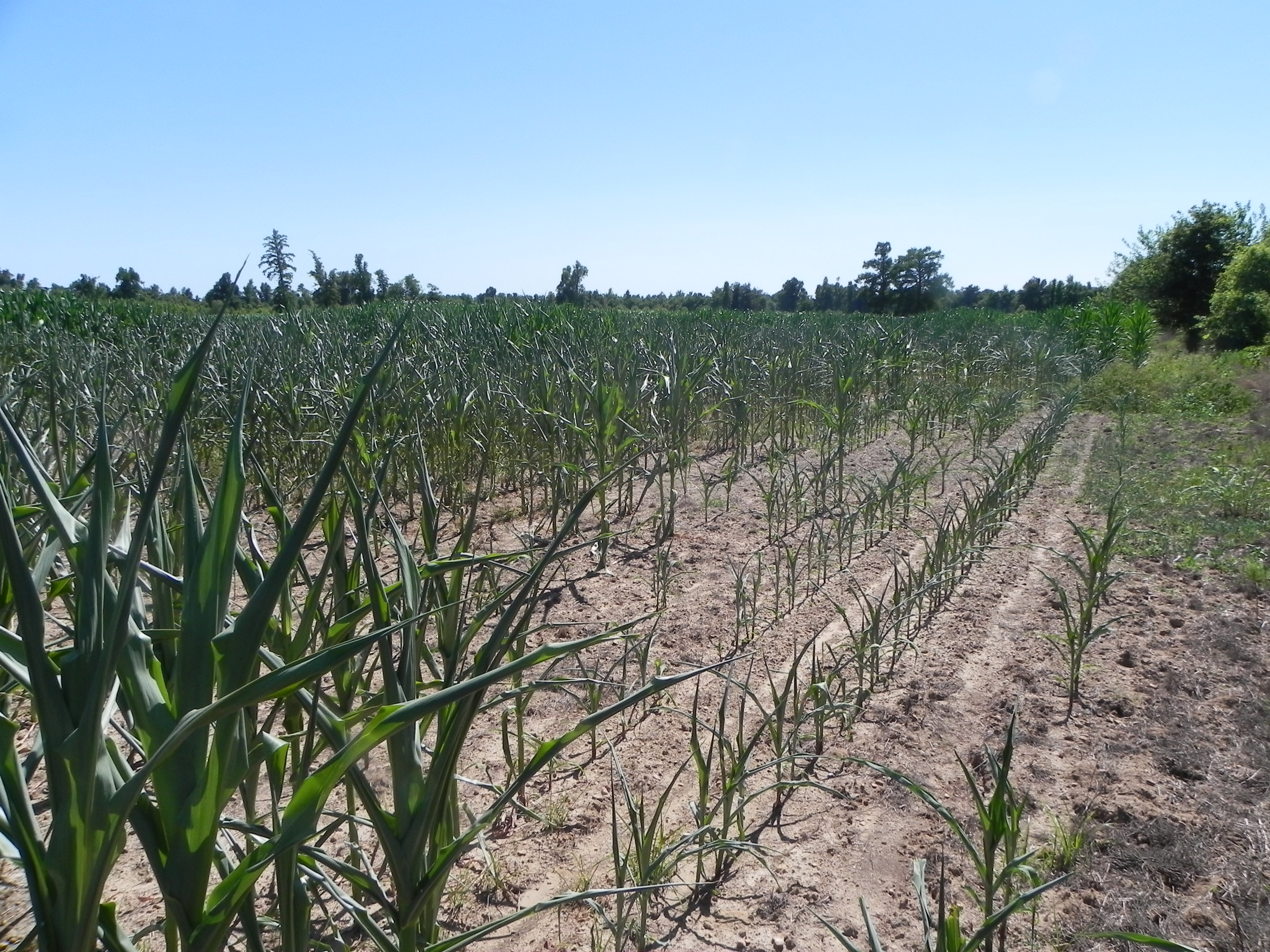 |
| Courtesy Douglas Wilson |
| McCracken County
|
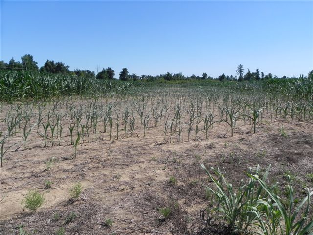 |
| Courtesy of Douglas Wilson
| | McCracken County
|
2012 Year to Date Kentucky Climate Summary
2012 has been completely different from any other year on record. Each
season has been far from normal and has been dominated by different features. Spring
seemed to come early this year as warm temperatures dominated the latter half of
winter. Severe weather started nearly a month ahead of normal. June and July have
been known for the historic drought that took hold of the country, while the
beginning of August brought more fall-like temperatures. The abnormal year did not
stop there as going into the fall season, the remnants of 2 hurricanes passed through
the state, just before a major warm up going into the beginning of December. The
following article strives to give a sense of how different this year has been from
years past.
____________________________________________________________________________________________________

The year started off with an incredibly mild winter and very little snowfall.
Did we even have a winter? Temperatures were above normal for the entire season and
ended 11 degrees above normal for the month of March. This ended up being the warmest
March on record for the Bluegrass State. The spring-like temperatures led to severe
weather instances starting about a month ahead of normal. As of the end of February
and into March, the weather pattern had shifted to support strong to severe
thunderstorms and some tornados. This started as early as Leap Day, as several
tornados ripped through the Ohio Valley. The worst of the severe weather happened on
March 2nd as a powerful storm system initiated large scale tornados, with an EF4
tornado touching down just north of Louisville. The picture to the right was
provided by the Louisville NWS and displays the monstrous tornado as it moves near
New Pekin, Indiana.
The record warmth in March allowed for farmers to start planting earlier than
normal. Unbeknownst to them at the time, 2012 would lay claim to one of the worst
agricultural droughts of all time. As was the winter season, spring was also very
dry. April is supposed to be known for a more vigorous weather pattern with multiple
chances of rainfall and severe weather. April of 2012 was nearly the exact opposite.
Kentucky ended the month almost 2.5 inches of rainfall below normal and drought
started to set in upon the Bluegrass State. Temperatures returned to near normal, but
this was short-lived. By May, warm temperatures were making a comeback with
temperatures on average, 12 degrees warmer across Kentucky during the first week of
the month. The warming trend became significant during the last 2 weeks of June when
temperatures started to exceed 100 degrees on a daily basis and break records across
the state. Drought continued to deepen and expand throughout the month. The entire
state of Kentucky only averaged 0.88 inches of precipitation in June, which was 3.5
inches below normal. This resulted in the second driest June on record for the
Bluegrass State. As of the end of June, most areas of the state were under moderate
to extreme drought conditions.
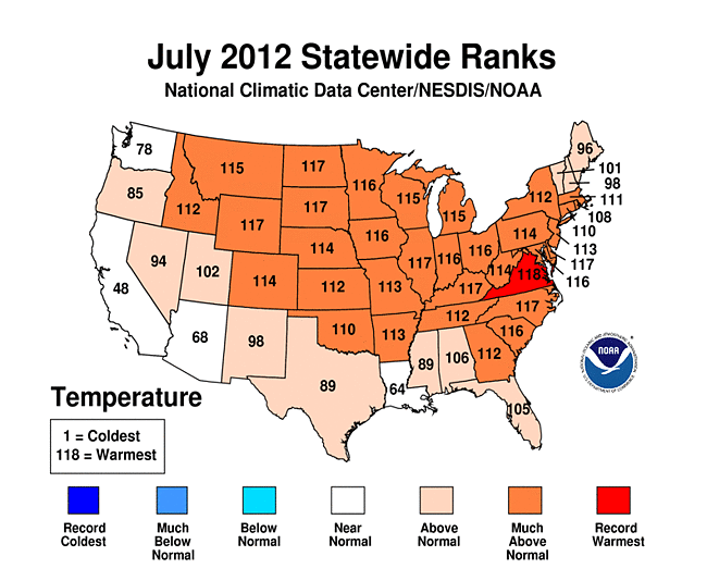
Scorching heat and high humidity carried over to the month of July. Kentucky
witnessed its 3rd warmest July on record. This is nearly an understatement compared
to the contiguous United States as a whole, which experienced the warmest July ever
recorded at an average temperature of 77.6 degrees. The previous record was set back
in the dust bowl year of 1936, when the average U.S. temperature was 77.4 degrees
(National Climatic Data Center). July accounted for 9th straight month of
above normal temperatures here in the Bluegrass State. The image to the right displays the record
warming trend across the United States.
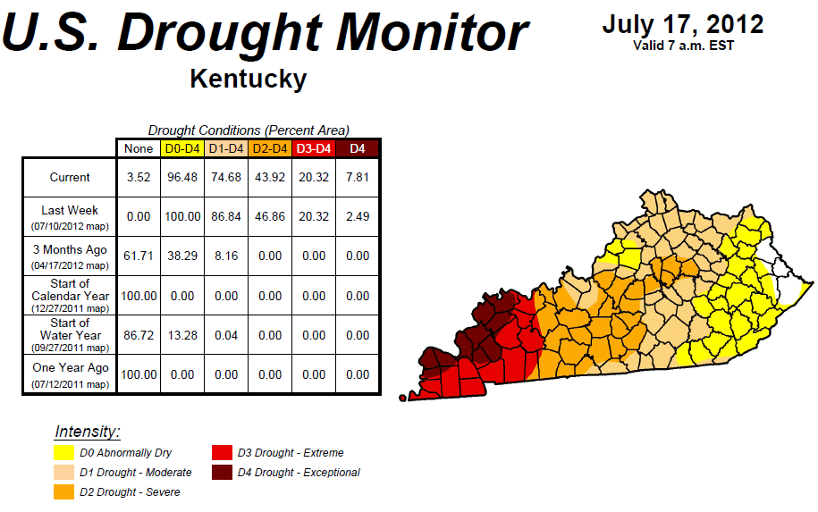
By the middle of July, drought had overtaken nearly the entire state.
Western portions of the Commonwealth were hardest hit with exceptional drought
conditions. The impacts were severe and were displayed both hydrologically and
agriculturally. On a positive note, near the end of July, mainly eastern and central
portions of Kentucky did start to see significant amounts of rainfall as cold fronts
moved through the area on nearly a weekly basis. This created abrupt and very
significant drought turnaround periods. Going into the last 2 weeks of July, the
entire state of Kentucky was in agricultural despair as drought took hold of the
lower Ohio Valley. By the end of July; only western sections remained in extreme
drought hardship.
Fall seemed to come early during the middle 2 weeks of August. The passage of
a strong cold front had temperatures only topping out in the upper 70s to mid 80s.
This was around 6 degrees below normal for this time of the year. By the end of the
month, the remnants of the earlier known Hurricane Isaac made themselves up through
the Ohio Valley. This was the first major tropical system to progress into Kentucky
since Hurricane Dennis and Katrina back in 2005.
Weather conditions seemed to make a complete 180 going into September, where
the Commonwealth got drenched. Kentucky ended the month over 2 inches above normal as
a combination of the remnants of Isaac and multiple frontal passages made for a very
wet pattern. The state hasn't seen this much rainfall since November of 2011. Midway
through the fall season, conditions took another turn. First off, Kentucky was
welcomed by yet another hurricane. The remnants of Hurricane Sandy soaked eastern
portions of the state with around 2 inches of rainfall. Some higher elevations even
saw over a foot of snow. After this system, rainfall seemed to taper off through the
month of November. It was the 5th driest November on record since 1895 with the state
over 2.5 inches below normal. Over the course of the month, most of the state had
slipped back into abnormally dry conditions.

The year ended with a very mild December, as the Commonwealth saw its 8th month
of 2012 with above normal temperatures. It was the 7th warmest December on record
going back to 1895. The warm temperatures were led in the first week of the month
where strong southwesterly flow put temperatures on average, 15 degrees above normal.
The state also saw the skies open up after an extremely dry November. Numerous
frontal boundaries and disturbances soaked the Commonwealth with on average, around 5
inches of rainfall. A couple strong low pressure systems also brought some
significant snowfall events toward the end of the month with totals in excess of 6
inches falling in western Kentucky the day after Christmas. The figure to the right was provided by
the National Weather Service Office in Louisville and shows a high resolution visible
satellite image taken on December 30th of the snowpack across the region following
the 2 snowfall events.
So overall the state did see quite a few extremes throughout the year. The
drought was truly evident in the rainfall data. The western climate division ended
the year with only 32.94 inches of precipitation, which made for the driest year
going all the way back to 1963, where just over 30 inches was recorded. The state as
a whole ended the year with an average of just over 40 inches, making it the driest
since 2005. Overall, Kentucky was over 7 inches below normal with 8 of the 12 months
seeing below normal precipitation. Temperature wise, the west also saw a very warm
year with an average temperature of 60.8 degrees. This makes for the warmest year on
record going back to 1895. 2012 also now holds name to the warmest year on record for
Louisville, in addition to the second warmest year for Lexington at 60.8 and 57.6
degrees, respectively. So, what does 2013 have in store for the Commonwealth? Just
like the 2012, only time will tell what truly happens.
|

 |
 |
Ag Weather Center, Department of Biosystems & Agricultural Engineering, University of Kentucky
![[Header Map]](/images/header.gif)