...The mission of the UK Agricultural Weather Program/Center is to provide
educational resources through the development of agricultural weather products
and services that minimize weather surprise to Kentucky residents relative to
their agricultural needs...
Detailed forecast information is available in your Precision Ag Weather
forecast here...
-=-=-=-=-=-=-=--=-=-=-=-=-=-=-=-
Long-range outlooks here.
Where is Spring?
The new spring season officially started at 7:02 on the 20th, but more than
anything, it felt like the middle of January. This past month has been extremely
cool with a state average temperature of 4 degrees below normal through March 20th.
Just this past 3 days (3/18 – 3/20), highs have been averaging a very cool, 9 degrees
below normal statewide, with lows following suit at 4 degrees below normal. Average
highs across the state for this time of the year are suppose to be in the upper 50s
to low 60s with lows only dropping into the upper 30s. The rest of the month doesn't
look any better. This upcoming week will feature highs staying mostly in the 40s
across the state. The short term outlooks don't provide any hints at spring either.
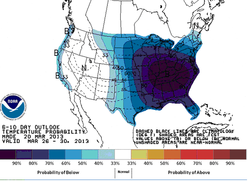
The 6 to 10 day outlook going out to March 30th, as shown to the right, has well below
normal temperatures expected for the Commonwealth. So what is causing this cool
pattern? Although we can look at local weather conditions for an answer, looking at
a larger spatial scale is also required.
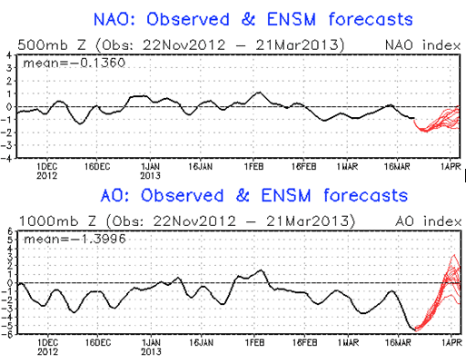
Over the past month, the eastern portion of the country has been locked into the
negative phase of the Arctic (AO) and North Atlantic (NAO) Oscillations. Similar to
El Nino/La Nina, these oscillations also play a large role influencing the weather
patterns across the globe. The North Atlantic Oscillation is dependent upon pressure
patterns in you guessed it, the North Atlantic. These patterns play a large role in
winter weather across the Eastern United States. Currently the NAO is in a negative
phase, which means a “blocking pattern” has setup in which a ridge of high pressure
acts to keep an enhanced trough of low pressure over the Eastern United States. This
results in much cooler temperatures, as the Bluegrass State is more susceptible to
Canadian or even Arctic outbreaks.
The Arctic Oscillation, on the other hand, is located in the Northern Polar
Regions. This oscillation is affected by the large scale difference in temperatures
between this region and the equator. This difference has an affect on large scale
wind patterns. Currently, the oscillation is in a negative mode. This results in a
weakening of the polar low pressure system, which allows for much weaker winds aloft.
Much colder air and more Arctic outbreaks are common during this period across the
Eastern United States.
Both of the above oscillations have been in a negative mode for the entire month
of March, providing very cool conditions across the Eastern United States, including
the Commonwealth. Luckily, these oscillations can change over the course of weeks,
and with other subtle hints, the end may be in sight. The negative mode can be shown
in the charts to the left, and as indicated by the “red” forecasts, each oscillation is
expected to make a run toward positive going into early April. A positive mode would
indicate a return to above normal temperatures.
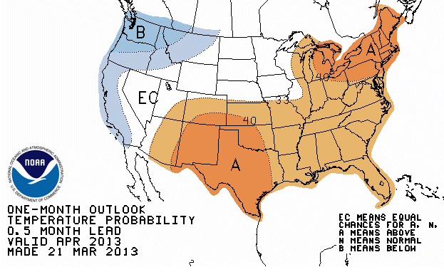
The great news that came out recently (3/21/2013) is the fact of outlooks
trending toward above normal temperatures in both April (shown to the right) and the
3 month outlook out to June. This is a welcoming sign as the Commonwealth gets
further established into the planting season and horticultural crops having already
been delayed.
While temperatures will remain cool through the end of March, it is expected Kentucky will
also continue in an unsettled and wet weather pattern. Since the start of March, the
Commonwealth has averaged nearly 4 inches of rainfall, which is about an inch above
normal. This has just added to our already wet winter season where Kentucky were 2.57 inches
above normal over the course of December and January. The wet pattern looks to continue
this upcoming weekend and on into April. The 5 day rainfall outlook through
early next week is predicting anywhere from another half to one inch falling across the
area. The latest one month outlook for April is also suggesting above normal precipitation.
This is in addition to above normal precipitation expected the next 3 months into June.
In summary, the upcoming planting season looks to resemble years past. In typical Ohio
Valley fashion, the weather pattern will throw another curveball at the planting season.
While well below normal temperatures and wet conditions will continue to postpone field operations through the
end of March, a warm up is expected going into early April. More information on your specific farm's forecast through the next 7
day's can be found here or more
information on the outlooks here.
A more in depth perspective of oscillations across the globe can be found
here.
|

 |
 |
Ag Weather Center, Department of Biosystems & Agricultural Engineering, University of Kentucky
![[Header Map]](/images/header.gif)