-=-=-=-=-=-=-
Severe Weather Safety Tips Click Here
-=-=-=-=-=- What is UTC time? Click
here
to find out.... Mouseover to pause!......
Kentucky Short-term forecast...
Detailed forecast information is available in your Precision Ag Weather forecast
here.
.. -=-=-=-=-=-=-=-=-=-=-=-=-=-=-=- Long-range outlooks
here.
UKAWC Weather Map Carousel
Last update: Mon Mar 10 00:42:04 EDT 2025
[US Rad]
,
[IR Sat]
,
[VIS]
,
[WW]
,
[NatRad]
,
[Temps]
,
[LSI]
,
[Wind]
,
[QPF]
,
[5-day]
,
[WCI]
,
[DewP]
,
[Sat/Sfc/Rad]
,
[Today]
,
[Tom.]
,
[NextDay]
,
[12Hr]
,
[24Hr]
,
[36Hr]
,
[36Hr]
,
[48Hr]
,
[60Hr]
,
[3-5 day]
,
[7-day Threats]
[850mb]
,
[500mb]
,
[Thick]
,
ALL
,
wxcarousel2
Webcasts:
County NWS Hazardous Weather
,
Hourly Ag Weather Conditions
,
Kentucky Ag Weather Synopsis
,
w/Maps
,
Kentucky Weekly Climate Report
,
w/Maps
,
Kentucky Weather & Crop Report
,
Select radar by NWS office
Radars by State
Birmingham
E. Alabama
Fort Rucker
Mobile
Nrn. Alabama
Bethel
Biorka Is.
Fairbanks
Kenai
King Salmon
Middleton Is.
Nome
Pedro Dome
Sitka
Flagstaff
Phoenix
Tucson
Little Rock
W. Ark./Ft. Smith
Eureka
Hanford
Los Angeles
Sacramento
San Diego
San Francisco
San Joaquin Vly.
Denver/Boulder
Grand Junction
Pueblo
Dover AFB
Eglin AFB
Jacksonville
Key West
Melbourne
Miami
NW Florida
Tallahassee
Tampa Bay Area
Atlanta
Moody AFB
Peachtree City
Robins AFB
Boise
Pocatello
Central IL
Chicago
Evansville
Indianapolis
Nrn. Indiana
Des Moines
Quad Cities
Dodge City
Goodland
Topeka
Wichita
Jackson
Louisville
Paducah
Fort Polk
Lake Charles
New Orleans
Shreveport
Caribou
Portland
Baltimore
Boston
Detroit
Gaylord
Grand Rapids
Marquette
Duluth
Minneapolis
Columbus AFB
Jackson/Brandon
Kansas City
Springfield
St. Louis
Billings
Glasgow
Great Falls
Missoula
Hastings
North Platte
Omaha
Elko
Las Vegas
Reno
Mt. Holly
Albuquerque
Cannon AFB
Holloman AFB
Albany
Binghamton
Buffalo
Montague
New York City
Upton
Durham
Morehead City
Raleigh
Wilmington
Bismarck
Grand Forks
Minot AFB
Cincinnati
Cleveland
Dayton
Wilmington
Frederick
Oklahoma City
Tulsa
Vance AFB
Medford
Pendleton
Portland
Philadelphia
Pittsburgh
State College
Charleston
Columbia
Greenville
Spartanburg
Greer
Aberdeen
Rapid City
Sioux falls
Knoxville
Memphis
Morristown
Nashville
Tri Cities
Amarillo
Austin
Brownsville
Central Texas
Corpus Christi
Dallas
El Paso
Fort Worth
Galveston
Houston
Laughlin AFB
Lubbock
Midland/Odessa
San Angelo
San Antonio
Cedar City
Salt Lake City
Burlington
Blacksburg
Norfolk
Richmond
Roanoke
Sterling
Wakefield
Seattle
Spokane
Tacoma
Washington
Charleston
Green Bay
La Crosse
Milwaukee
Cheyenne
Riverton
To stop the weather map carousel, place the mouse over the map (Page will refresh every 10 minutes)
:
Mouseover to pause! Click here
to zoom!
Mouseover to pause! Click here
to zoom!
Mouseover to pause!

 Mouseover to pause! Click here  to zoom!
Mouseover to pause!......
-=-=-=-=-=-=-
Severe Weather Safety Tips Click Here
-=-=-=-=-=-
...The mission of the UK Agricultural Weather Program/Center is to provide educational resources through the development of agricultural weather products and services that minimize weather surprise to Kentucky residents relative to their agricultural needs...
Detailed forecast information is available in your Precision Ag Weather forecast
here.
.. -=-=-=-=-=-=-
Severe Weather Safety Tips Here
-=-=-=-=-=- Long-range outlooks
here.
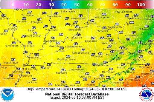
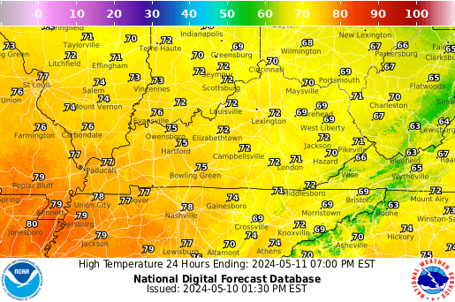
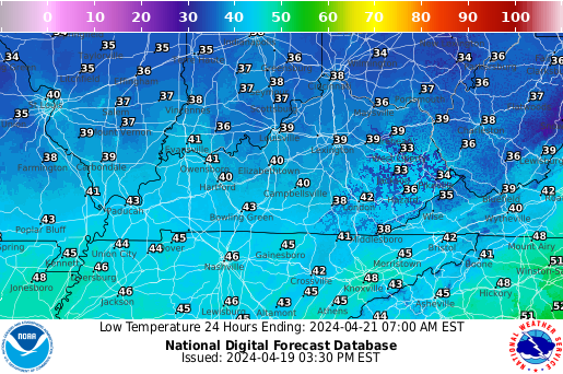
Temperature
Next 12 Hrs
Next 24 Hrs
Next 36 Hrs
Next 48 Hrs
Probability of Precipitation
Next 12 Hrs
Next 24 Hrs
Next 36 Hrs
Next 48 Hrs
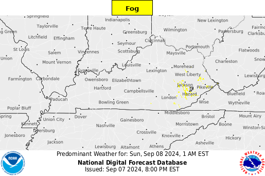
Weather Conditions
Next 12 Hrs
Next 24 Hrs
Next 36 Hrs
Next 48 Hrs
Winds
Next 12 Hrs
Next 24 Hrs
Next 36 Hrs
Next 48 Hrs


![[IR Sat]](http://www.ssec.wisc.edu/data/east/latest_eastir.gif)
![[WW]](http://www.spc.noaa.gov/products/wwa/wwa.gif)
![[NatRad]](http://www.srh.noaa.gov/ridge/Conus/Loop/NatLoop.gif)
![[Temps]](/ldm-images/latestregtemp.gif)
![[Wind]](/ldm-images/latestwind.gif)
![[QPF]](http://www.hpc.ncep.noaa.gov/qpf/fill_94qwbg.gif)
![[5-day]](http://www.hpc.ncep.noaa.gov/qpf/p120i12.gif)
![[WCI]](/ldm-images/latestwci2.gif)
![[DewP]](/ldm-images/eta_dewp_ani.gif)
![[Sat/Sfc/Rad]](http://weather.unisys.com/images/sat_sfc_map_loop.gif)
![[Today]](http://www.hpc.ncep.noaa.gov/noaa/noaad1.gif)
![[Tom.]](http://www.hpc.ncep.noaa.gov/noaa/noaad2.gif)
![[NextDay]](http://www.hpc.ncep.noaa.gov/noaa/noaad3.gif)
![[12Hr]](http://adds.aviationweather.gov/data/progs/hpc_12_fcst.gif)
![[24Hr]](http://adds.aviationweather.gov/data/progs/hpc_24_fcst.gif)
![[36Hr]](http://adds.aviationweather.gov/data/progs/hpc_36_fcst.gif)
![[36Hr]](http://www.hpc.ncep.noaa.gov/basicwx/96f.gif)
![[48Hr]](http://www.hpc.ncep.noaa.gov/basicwx/98f.gif)
![[60Hr]](http://www.hpc.ncep.noaa.gov/basicwx/allfcsts_loop_wbg.gif)
![[3-5 day]](/ldm-images/nhmrf_3-5.tst.gif)
![[7-day Threats]](http://www.cpc.ncep.noaa.gov/products/predictions/threats/hazards_d3_7.png)
![[850mb]](/ldm-images/eta_850_ani.gif)
![[500mb]](/ldm-images/eta_500_ani.gif)
![[Thick]](/ldm-images/nhmrf_thick_ani.gif)