KENTUCKY CROP AND WEATHER REPORT--USDA
Listed below are the current USDA Crop & Weather Report/Kentucky Climate Summary
AND, in addition, previous week's reports for this year. The reports are
produced in a joint effort by the UK Ag. Weather Center, Cooperative Extension
Service County Agents, Farmers across the state, Kentucky Department of
Agriculture, and the US Department of Agriculture, National Agricultural
Statistics Service. Click here for the PDF version.
---
Kentucky Climate Summary
For the Period December 31 to January 6, 2019
Well Above Normal Temperatures and Precipitation:
The Bluegrass State cannot seem to get a break from continued rainfall. Kentucky saw
another couple of rounds this period, one coming on New Year’s Eve and the other
later in the workweek. Both brought widespread rounds of light to moderate showers
to the area, leading to some nuisance flooding. All together, the state average 2.14
inches for the first week of 2019, over an inch above normal for this time of year.
Following the unsettled workweek, dry conditions returned for the weekend with high
temperatures back in the 50s. This warmth pushed Kentucky to a fourth straight week
of above normal temperatures.
Temperatures for the period averaged 45 degrees across the state which was 11 degrees
warmer than normal and 2 degrees warmer than the previous period. High temperatures
averaged from 49 in the West to 55 in the East. Departure from normal high
temperatures ranged from 6 degrees warmer than normal in the West to 11 degrees
warmer than normal in the East. Low temperatures averaged from 38 degrees in the
West to 40 degrees in the East. Departure from normal low temperature ranged from 12
degrees warmer than normal in the West to 16 degrees warmer than normal in the
East. The extreme high temperature for the period was 73 degrees at WHITESBURG 2NW
and the extreme low was 27 degrees at CARBONDALE ASOS.
Precipitation (liq. equ.) for the period totaled 2.14 inches statewide which was 1.25
inches above normal and 240% of normal. Precipitation totals by climate division,
West 1.95 inches, Central 2.35 inches, Bluegrass 2.11 inches and East 2.14 inches,
which was 1.02, 1.39, 1.34 and 1.24 inches above normal. By station, precipitation
totals ranged from a low of 1.29 inches at LOUISA 1S to a high of 3.61 inches at
WHITLEY CITY 3N.
---
Kentucky Climate Summary
For the Period December 24 to December 30, 2018
Above Normal Temperatures and Below Normal Precipitation:
Mild weather highlighted the final week of 2018. The first half of the week,
including the Christmas holiday, was dry for the Bluegrass State with high
temperatures increasing through the 40s and into the 50s. Widespread showers
returned on Thursday and Thursday night as a couple disturbances moved through the
state. Winds did get very breezy with gusts in excess of 40s mph and isolated 50 mph
wind gusts. Overall, this was the only rain event for the week as the state averaged
0.58 inches. Mild and dry conditions returned over the weekend with above normal
temperatures back in place. Kentucky ended up closing 2018 with three straight weeks
of above normal temperatures.
Temperatures for the period averaged 42 degrees across the state which was 7 degrees
warmer than normal and 2 degrees warmer than the previous period. High temperatures
averaged from 51 in the West to 51 in the East. Departure from normal high
temperatures ranged from 6 degrees warmer than normal in the West to 5 degrees warmer
than normal in the East. Low temperatures averaged from 34 degrees in the West to 34
degrees in the East. Departure from normal low temperature ranged from 7 degrees
warmer than normal in the West to 8 degrees warmer than normal in the East. The
extreme high temperature for the period was 64 degrees at BOONEVILLE 2S and the
extreme low was 20 degrees at CYNTHIANA 8N.
Precipitation (liq. equ.) for the period totaled 0.58 inches statewide which was 0.35
inches below normal and 62% of normal. Precipitation totals by climate division, West
0.57 inches, Central 0.63 inches, Bluegrass 0.34 inches and East 0.77 inches, which
was 0.41, 0.38, 0.49 and 0.14 inches below normal. By station, precipitation totals
ranged from a low of 0.13 inches at MT STERLING AWOS to
a high of 1.86 inches at WHITLEY CITY 3N.
---
Kentucky Climate Summary
For the Period December 17 to December 23, 2018
Above Normal Temperatures and Precipitation:
Sunny skies and mild conditions opened up the first half of the period with high
pressure in place. As this high shifted east on Wednesday, southerly flow bumped
high temperatures into the middle 50s to around 60. Showers then started working into
the area on Wednesday night and expanding across the entire state on Thursday.
Widespread light to moderate rain led to a soaking rainfall and was then followed by
additional light showers on Friday. Overall, the state averaged just over an inch
with higher accumulations across Eastern Kentucky and less so across Western
Kentucky. This marked the second straight week of above normal precipitation for the
state.
Temperatures for the period averaged 40 degrees across the state which was 3 degrees
warmer than normal and 2 degrees cooler than the previous period. High temperatures
averaged from 49 in the West to 47 in the East. Departure from normal high
temperatures ranged from 2 degrees warmer than normal in the West to near normal in
the East. Low temperatures averaged from 33 degrees in the West to 33 degrees in the
East. Departure from normal low temperature ranged from 4 degrees warmer than normal
in the West to 6 degrees warmer than normal in the East. The extreme high temperature
for the period was 61 degrees at FORT CAMPBELL and the extreme low was 22 degrees at
CYNTHIANA 8N.
Precipitation (liq. equ.) for the period totaled 1.05 inches statewide which was 0.08
inches above normal and 108% of normal. Precipitation totals by climate division,
West 0.40 inches, Central 1.14 inches, Bluegrass 1.09 inches and East 1.59 inches,
which was -0.66, 0.08, 0.25 and 0.67 inches respectively from normal. By station,
precipitation totals ranged from a low of 0.10 inches at HICKMAN 2E to a high of 2.71
inches at PIKEVILLE 13S.
---
Kentucky Climate Summary
For the Period December 10 to December 16, 2018
Above Normal Temperatures and Precipitation:
The week started out with dry and cold conditions in place. Clearing skies and calm
winds Monday night led to lows dropping well into the teens across the state. The
good news was that the rest of the week followed a much milder pattern with daily
highs getting into the 40s and 50s. In fact, it was the first week since the middle
of October that the state average temperature for the week was above normal. While it
was warmer, low pressure working across the area led to a soggy pattern for the
second half of the work week and lasting through Saturday. Periods of showers fell
across the area, widespread at times. All total, the state averaged 1.46 inches,
about a half inch above normal for this time of year.
Temperatures for the period averaged 43 degrees across the state which was 5 degrees
warmer than normal and 10 degrees warmer than the previous period. High temperatures
averaged from 51 in the West to 49 in the East. Departure from normal high
temperatures ranged from 3 degrees warmer than normal in the West to near normal in
the East. Low temperatures averaged from 36 degrees in the West to 35 degrees in the
East. Departure from normal low temperature ranged from 6 degrees warmer than normal
in the West to 7 degrees warmer than normal in the East. The extreme high temperature
for the period was 63 degrees at BOWLING GREEN APT and the
extreme low was 11 degrees at MONTICELLO AWOS.
Precipitation (liq. equ.) for the period totaled 1.46 inches statewide which was 0.44
inches above normal and 143% of normal. Precipitation totals by climate division,
West 2.02 inches, Central 0.99 inches, Bluegrass 1.21 inches and East 1.64 inches,
which was 0.91, -0.13, 0.32 and 0.67 inches respectively from normal. By station,
precipitation totals ranged from a low of 0.21 inches at SCOTTSVILLE 2W to a high of
3.41 inches at MORGANFIELD 4E.
---
Kentucky Climate Summary
For the Period December 3 to December 9, 2018
Below Normal Temperatures and Precipitation:
Kentucky has not quite reached the official start of winter, but it has seemed Mother
Nature has had different plans. This period marked the 8th straight week of near to
below normal temperatures. Winter cold stuck around the entirety of the week. Cloud
cover associated with a few disturbances kept temperatures in the 30s Monday thru
Wednesday, but also led to some periods of wintry weather. After some additional
light rounds later in the workweek, a major winter storm took shape over the weekend. South
Central Kentucky and Southeastern Kentucky saw the most impacts. Freezing rain fell
across South Central Kentucky with ice accumulations of a tenth to quarter inch. Snow
was the dominant type for Southeastern Kentucky with three to six+ inches common
across this area.
Temperatures for the period averaged 34 degrees across the state which was 7 degrees
cooler than normal and 8 degrees cooler than the previous period. High temperatures
averaged from 39 in the West to 38 in the East. Departure from normal high
temperatures ranged from 12 degrees cooler than normal in the West to 13 degrees
cooler than normal in the East. Low temperatures averaged from 31 degrees in the
West to 30 degrees in the East. Departure from normal low temperature ranged from 1
degree cooler than normal in the West to near normal in the East. The extreme high
temperature for the period was 57 degrees at MIDDLESBORO AWOS and the extreme low was
17 degrees at BURKESVILLE 3W.
Precipitation (liq. equ.) for the period totaled 0.30 inches statewide which was 0.78
inches below normal and 28% of normal. Precipitation totals by climate division, West
0.16 inches, Central 0.35 inches, Bluegrass 0.04 inches and East 0.65 inches, which
was 1.06, 0.8, 0.89 and 0.36 inches below normal. By station, precipitation totals
ranged from a low of 0.00 inches at FRANKFORT to a high of 1.72
inches at YELLOW CREEK.
---
Kentucky Climate Summary
For the Period November 26 to December 2, 2018
Below Normal Temperatures and Above Normal Precipitation:
In typical Kentucky fashion, the weather pattern changed drastically through the
week. Starting out, temperatures ran well below normal Monday and Tuesday. Breezy
conditions pushed wind chills into the 20s on Monday and teens later that night. High
temperatures then only made it to around 30 on Tuesday and with clouds breaking up
that night, plummeted into the teens. Along with the cold came some bouts of snow
showers, but that all came to an end rather quickly. By Friday, highs were back in
the 50s and 60s, staying that way through the weekend. Even had a few stations break
70. Along with the warmth, multiple rounds of rainfall pushed through the region.
While lighter rainfall fell Thursday and Friday, more significant activity swept
through the area Friday night and Saturday. After widespread showers early on with
the passage of a warm front, scattered thunderstorms formed later in the day.
Overall, the state averaged 1.67 inches of rainfall for the week. As a side note,
the annual rainfall record was broke in Lexington with a month remaining in the year!
As of December 3rd, Lexington has recorded 67.02 inches, which breaks the old record
of 66.35 set in 2011.
Temperatures for the period averaged 42 degrees across the state which was 1 degree
cooler than normal and 2 degrees cooler than the previous period. High temperatures
averaged from 49 in the West to 49 in the East. Departure from normal high
temperatures ranged from 5 degrees cooler than normal in the West to 5 degrees
cooler than normal in the East. Low temperatures averaged from 36 degrees in the
West to 35 degrees in the East. Departure from normal low temperature ranged from 1
degree warmer than normal in the West to 4 degrees warmer than normal in the East.
The extreme high temperature for the period was 71 degrees at BOONEVILLE 2S and the extreme
low was 11 degrees at HARTFORD 3E.
Precipitation (liq. equ.) for the period totaled 1.67 inches statewide which was 0.59
inches above normal and 154% of normal. Precipitation totals by climate division,
West 1.77 inches, Central 1.91 inches, Bluegrass 1.75 inches and East 1.25 inches,
which was 0.51, 0.76, 0.84 and 0.24 inches above normal. By station, precipitation
totals ranged from a low of 0.65 inches at MIDDLESBORO AWOS to a high of 2.80
inches at GLASGOW 11W.
---
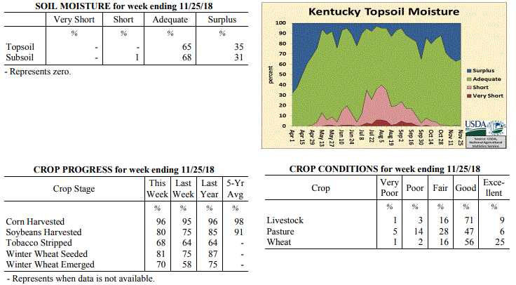
Kentucky Crop and Weather Report
Issued 4:00 P.M., November 26, 2018 40-18
Agricultural News: Kentucky experienced below normal temperatures and precipitation
over the past week. Precipitation for the week totaled 0.32 inches, 0.69 inches below
normal. Temperatures averaged 43 degrees for the week, 2 degrees below normal.
Topsoil moisture was rated 65 percent adequate and 35 percent surplus. Subsoil
moisture was rated 1 percent short, 68 percent adequate, and 31 percent surplus. Days
suitable for fieldwork averaged 3.3 out of a possible seven.
Primary activities this week included harvesting corn and soybeans, and stripping
tobacco. Soybean harvest has been continuously stalled by precipitation and poor
drying conditions for most of November. Yields and quality remain of concern, with
reports of farmers being docked for deteriorated quality and disease. Fields and
pastures remain saturated, some of the last cuttings of hay were lost due to the
inability to dry and bale. Hay and roughage supplies were reported as mostly
adequate. Some producers have “mudded in” the rest of their wheat crop, and any
remaining acres to be planted may likely be abandoned unless more favorable weather
conditions occur very soon.
 Kentucky Climate Summary
For the Period November 19 to November 25, 2018
Below Normal Temperatures and Precipitation:
The period started with cool, cloudy, and light rain showers in place on Monday.
That cloud cover stayed with the area through Tuesday, before diminishing for
Wednesday and the Thanksgiving holiday. Temperatures went on a warming trend through
the week, starting with highs in the 40s and eventually making it into the 50s and
60s by Friday and into the weekend. Light rain showers returned to the area Friday
night with a disturbance passing aloft and then again late Sunday.Overall, the state
as a whole averaged less than a third of an inch for the week and ended a three-week
stretch of above normal precipitation. Looking at the growing season from April to
October, data shows that 2018 was the sixth wettest on record for the Bluegrass State
with data going back to 1895.
Temperatures for the period averaged 43 degrees across the state which was 2 degrees
cooler than normal and 6 degrees warmer than the previous period. High temperatures
averaged from 53 in the West to 53 in the East. Departure from normal high
temperatures ranged from 3 degrees cooler than normal in the West to 3 degrees
cooler than normal in the East. Low temperatures averaged from 35 degrees in the
West to 35 degrees in the East. Departure from normal low temperature ranged from 1
degree cooler than normal in the West to 2 degrees warmer than normal in the East.
The extreme high temperature for the period was 64 degrees at CARBONDALE ASOS and the
extreme low was 19 degrees at ELKTON 5SW.
Precipitation (liq. equ.) for the period totaled 0.32 inches statewide which was 0.69
inches below normal and 32% of normal. Precipitation totals by climate division, West
0.22 inches, Central 0.27 inches, Bluegrass 0.42 inches and East 0.38 inches, which
was 0.94, 0.8, 0.46 and 0.54 inches below normal. By station, precipitation totals
ranged from a low of 0.08 inches at OWENSBORO AWSS to a high of 0.81 inches at
VANCEBURG 6W.
---
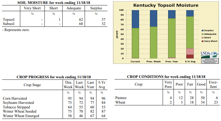
Kentucky Crop and Weather Report
Issued 4:00 P.M., November 19, 2018 39-18
Agricultural News: Kentucky experienced well below normal temperatures and above
normal precipitation over the past week. Precipitation for the week totaled 1.38
inches, 0.46 inches above normal. Temperatures averaged 38 degrees for the week, 10
degrees below normal. Topsoil moisture was rated 1 percent short, 62 percent adequate
and 37 percent surplus. Subsoil moisture was rated 68 percent adequate, and 32
percent surplus. Days suitable for fieldwork averaged 2.5 out of a possible seven.
Primary activities this week included harvesting corn and soybeans, stripping
tobacco, and planting winter wheat when weather conditions permitted. Harvesting and
planting continued to be limited this week by rainfall, freezing rain, and snowfall
across most of the state. The ice accumulation caused some lodging in unharvested
soybeans, and delays in harvesting have some beans starting to pop resulting in lower
yields and quality.
Wheat planting has been delayed for several weeks due to weather conditions, and some
producers are considering abandoning winter wheat acres and taking prevented planting
through crop insurance. The winter wheat that has been planted is slow to germinate
due to the cold and wet soils. Fall breeding of cattle has begun; pastures remain
muddy from frequent precipitation events this fall.
Kentucky Climate Summary
For the Period November 19 to November 25, 2018
Below Normal Temperatures and Precipitation:
The period started with cool, cloudy, and light rain showers in place on Monday.
That cloud cover stayed with the area through Tuesday, before diminishing for
Wednesday and the Thanksgiving holiday. Temperatures went on a warming trend through
the week, starting with highs in the 40s and eventually making it into the 50s and
60s by Friday and into the weekend. Light rain showers returned to the area Friday
night with a disturbance passing aloft and then again late Sunday.Overall, the state
as a whole averaged less than a third of an inch for the week and ended a three-week
stretch of above normal precipitation. Looking at the growing season from April to
October, data shows that 2018 was the sixth wettest on record for the Bluegrass State
with data going back to 1895.
Temperatures for the period averaged 43 degrees across the state which was 2 degrees
cooler than normal and 6 degrees warmer than the previous period. High temperatures
averaged from 53 in the West to 53 in the East. Departure from normal high
temperatures ranged from 3 degrees cooler than normal in the West to 3 degrees
cooler than normal in the East. Low temperatures averaged from 35 degrees in the
West to 35 degrees in the East. Departure from normal low temperature ranged from 1
degree cooler than normal in the West to 2 degrees warmer than normal in the East.
The extreme high temperature for the period was 64 degrees at CARBONDALE ASOS and the
extreme low was 19 degrees at ELKTON 5SW.
Precipitation (liq. equ.) for the period totaled 0.32 inches statewide which was 0.69
inches below normal and 32% of normal. Precipitation totals by climate division, West
0.22 inches, Central 0.27 inches, Bluegrass 0.42 inches and East 0.38 inches, which
was 0.94, 0.8, 0.46 and 0.54 inches below normal. By station, precipitation totals
ranged from a low of 0.08 inches at OWENSBORO AWSS to a high of 0.81 inches at
VANCEBURG 6W.
---
Kentucky Crop and Weather Report
Issued 4:00 P.M., November 19, 2018 39-18
Agricultural News: Kentucky experienced well below normal temperatures and above
normal precipitation over the past week. Precipitation for the week totaled 1.38
inches, 0.46 inches above normal. Temperatures averaged 38 degrees for the week, 10
degrees below normal. Topsoil moisture was rated 1 percent short, 62 percent adequate
and 37 percent surplus. Subsoil moisture was rated 68 percent adequate, and 32
percent surplus. Days suitable for fieldwork averaged 2.5 out of a possible seven.
Primary activities this week included harvesting corn and soybeans, stripping
tobacco, and planting winter wheat when weather conditions permitted. Harvesting and
planting continued to be limited this week by rainfall, freezing rain, and snowfall
across most of the state. The ice accumulation caused some lodging in unharvested
soybeans, and delays in harvesting have some beans starting to pop resulting in lower
yields and quality.
Wheat planting has been delayed for several weeks due to weather conditions, and some
producers are considering abandoning winter wheat acres and taking prevented planting
through crop insurance. The winter wheat that has been planted is slow to germinate
due to the cold and wet soils. Fall breeding of cattle has begun; pastures remain
muddy from frequent precipitation events this fall.
 Kentucky Climate Summary
For the Period November 12 to November 18, 2018
Well Below Normal Temperatures and Above Normal Rainfall:
Winter came early for the Bluegrass State as temperatures ran below normal for a
second straight week and a wintry mix of precipitation fell on several occasions. The
most significant event came Wednesday night and into Thursday. A Winter Weather
Advisory was issued for the majority of the state. Freezing rain fell across much of
Central Kentucky and the Bluegrass with numerous accumulations between a tenth and
quarter inch. Ice accumulations were mainly limited to elevated surfaces with warm
ground temperatures in place. While this mitigated road impacts, the ice did lead to
many downed limbs and associated power outages. Precipitation fell in the form of
snow for extreme portions of Western Kentucky with accumulations between 1 and 2
inches. Combined with additional rain showers on Monday/Sunday and other light snow
events, accumulations averaged 1.2 inches for the week. Behind the winter weather,
Kentucky saw a warming trend through the weekend, increasing into the 50s on Saturday
and Sunday.
Temperatures for the period averaged 38 degrees across the state which was 10 degrees
cooler than normal and 6 degrees cooler than the previous period. High temperatures
averaged from 43 in the West to 46 in the East. Departure from normal high
temperatures ranged from 16 degrees cooler than normal in the West to 13 degrees
cooler than normal in the East. Low temperatures averaged from 31 degrees in the
West to 32 degrees in the East. Departure from normal low temperature ranged from 8
degrees cooler than normal in the West to 3 degrees cooler than normal in the East.
The extreme high temperature for the period was 65 degrees at BENTON 4N and the
extreme low was 18 degrees at CARBONDALE ASOS.
Precipitation (liq. equ.) for the period totaled 1.38 inches statewide which was 0.46
inches above normal and 151% of normal. Precipitation totals by climate division,
West 0.77 inches, Central 1.68 inches, Bluegrass 1.44 inches and East 1.61 inches,
which was -0.31, 0.72, 0.65 and 0.78 inches respectively from normal. By station,
precipitation totals ranged from a low of 0.14 inches at POPLAR BLUFF ASOS to a high
of 2.59 inches at GREENVILLE 6N.
---
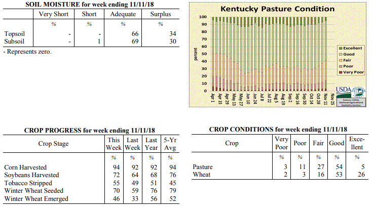
Kentucky Crop and Weather Report
Issued 4:00 P.M., November 13, 2018 38-18
Agricultural News: Kentucky experienced below normal temperatures and above normal
rainfall over the past week. Precipitation for the week totaled 2.06 inches, 1.28
inches above normal. Temperatures averaged 45 degrees for the week, 5 degrees below
normal. Topsoil moisture was rated 66 percent adequate and 34 percent surplus.
Subsoil moisture was rated 1 percent short, 69 percent adequate, and 30 percent
surplus. Days suitable for fieldwork averaged 2.8 out of a possible seven.
Primary activities this week included harvesting corn and soybeans, planting wheat,
and stripping tobacco. Continued precipitation and forecasted rainfall in the
upcoming week led to delays in fieldwork without adequate time for fields to dry out.
Soybean quality and yields remain of concern with over-maturity, saturated soils, and
deteriorated pods. Some low lying soybean fields have been flooded, and as a result
winter wheat planting decisions are in question in these areas due to the water level.
Kentucky Climate Summary
For the Period November 12 to November 18, 2018
Well Below Normal Temperatures and Above Normal Rainfall:
Winter came early for the Bluegrass State as temperatures ran below normal for a
second straight week and a wintry mix of precipitation fell on several occasions. The
most significant event came Wednesday night and into Thursday. A Winter Weather
Advisory was issued for the majority of the state. Freezing rain fell across much of
Central Kentucky and the Bluegrass with numerous accumulations between a tenth and
quarter inch. Ice accumulations were mainly limited to elevated surfaces with warm
ground temperatures in place. While this mitigated road impacts, the ice did lead to
many downed limbs and associated power outages. Precipitation fell in the form of
snow for extreme portions of Western Kentucky with accumulations between 1 and 2
inches. Combined with additional rain showers on Monday/Sunday and other light snow
events, accumulations averaged 1.2 inches for the week. Behind the winter weather,
Kentucky saw a warming trend through the weekend, increasing into the 50s on Saturday
and Sunday.
Temperatures for the period averaged 38 degrees across the state which was 10 degrees
cooler than normal and 6 degrees cooler than the previous period. High temperatures
averaged from 43 in the West to 46 in the East. Departure from normal high
temperatures ranged from 16 degrees cooler than normal in the West to 13 degrees
cooler than normal in the East. Low temperatures averaged from 31 degrees in the
West to 32 degrees in the East. Departure from normal low temperature ranged from 8
degrees cooler than normal in the West to 3 degrees cooler than normal in the East.
The extreme high temperature for the period was 65 degrees at BENTON 4N and the
extreme low was 18 degrees at CARBONDALE ASOS.
Precipitation (liq. equ.) for the period totaled 1.38 inches statewide which was 0.46
inches above normal and 151% of normal. Precipitation totals by climate division,
West 0.77 inches, Central 1.68 inches, Bluegrass 1.44 inches and East 1.61 inches,
which was -0.31, 0.72, 0.65 and 0.78 inches respectively from normal. By station,
precipitation totals ranged from a low of 0.14 inches at POPLAR BLUFF ASOS to a high
of 2.59 inches at GREENVILLE 6N.
---
Kentucky Crop and Weather Report
Issued 4:00 P.M., November 13, 2018 38-18
Agricultural News: Kentucky experienced below normal temperatures and above normal
rainfall over the past week. Precipitation for the week totaled 2.06 inches, 1.28
inches above normal. Temperatures averaged 45 degrees for the week, 5 degrees below
normal. Topsoil moisture was rated 66 percent adequate and 34 percent surplus.
Subsoil moisture was rated 1 percent short, 69 percent adequate, and 30 percent
surplus. Days suitable for fieldwork averaged 2.8 out of a possible seven.
Primary activities this week included harvesting corn and soybeans, planting wheat,
and stripping tobacco. Continued precipitation and forecasted rainfall in the
upcoming week led to delays in fieldwork without adequate time for fields to dry out.
Soybean quality and yields remain of concern with over-maturity, saturated soils, and
deteriorated pods. Some low lying soybean fields have been flooded, and as a result
winter wheat planting decisions are in question in these areas due to the water level.
 Kentucky Climate Summary
For the Period November 5 to November 11, 2018
Below Normal Temperatures and Above Normal Rainfall:
Kentucky saw a second straight week of above normal precipitation with a state
average over two inches for the period. The brunt of the rainfall fell Monday night
as widespread showers formed ahead of a cold front. A very moist air mass in place
led to moderate to heavy rainfall at times and produced between 1 and 2 inches across
much of the Commonwealth with this system alone. Numerous to widespread showers
formed yet again Thursday night and into Friday with highest accumulations closer to
an inch across Eastern Kentucky. Overall, it has been a very wet start to November
with data at the Ag Weather Center showing a state average of 3.27 inches through the
first eleven days of the month. Behind the second system, the coldest temperatures
of the fall season were seen Saturday and Sunday mornings with temperatures dipping
into the upper teens to middle 20s for much of the state.
Temperatures for the period averaged 45 degrees across the state which was 5 degrees
cooler than normal and 8 degrees cooler than the previous period. High temperatures
averaged from 52 in the West to 54 in the East. Departure from normal high
temperatures ranged from 11 degrees cooler than normal in the West to 8 degrees
cooler than normal in the East. Low temperatures averaged from 37 degrees in the
West to 38 degrees in the East. Departure from normal low temperature ranged from 4
degrees cooler than normal in the West to 2 degrees warmer than normal in the East.
The extreme high temperature for the period was 71 degrees at WHITESBURG 2NW and the
extreme low was 16 degrees at BRANDENBURG 4SW.
Precipitation (liq. equ.) for the period totaled 2.06 inches statewide which was 1.28
inches above normal and 263% of normal. Precipitation totals by climate division,
West 1.60 inches, Central 2.25 inches, Bluegrass 2.14 inches and East 2.24 inches,
which was 0.69, 1.43, 1.45 and 1.53 inches above normal. By station, precipitation
totals ranged from a low of 0.59 inches at FORT KNOX to a high of 3.62 inches at
CYNTHIANA 8N.
---
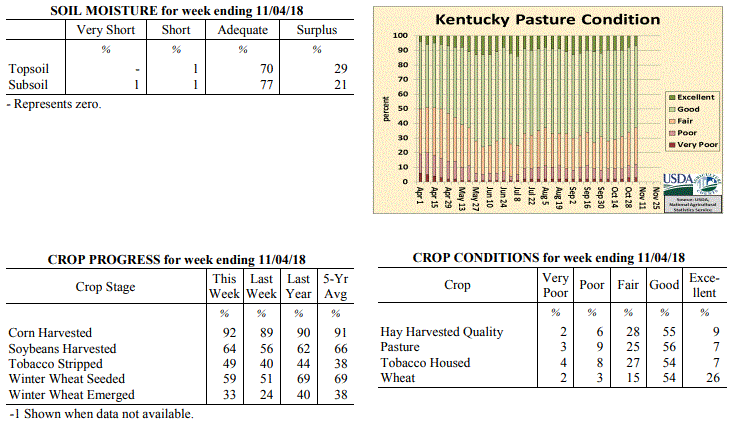
Kentucky Crop and Weather Report
Issued 4:00 P.M., November 5, 2018 36-18
Agricultural News: Kentucky experienced near normal temperatures and above normal
rainfall over the past week. Precipitation for the week totaled 1.64 inches, 0.88
inches above normal. Temperatures averaged 53 degrees for the week, near normal.
Topsoil moisture was rated 0 percent very short, 1 percent short, 70 percent adequate
and 29 percent surplus. Subsoil moisture was rated 1 percent very short, 1 percent
short, 77 percent adequate, and 21 percent surplus. Days suitable for fieldwork
averaged 3.7 out of a possible seven.
Primary activities for the week included harvesting corn and soybeans, sowing wheat,
and stripping tobacco. However, wet conditions hampered field activity and resulted
in some reports of quality issues in soybeans, lodging in corn and houseburn in
tobacco. Pastures are in mostly good condition with cattle and calves obtaining 59
percent of feed from them. Some hay is being fed. Eighty percent of the current wheat
crop is in good to excellent condition.
Kentucky Climate Summary
For the Period November 5 to November 11, 2018
Below Normal Temperatures and Above Normal Rainfall:
Kentucky saw a second straight week of above normal precipitation with a state
average over two inches for the period. The brunt of the rainfall fell Monday night
as widespread showers formed ahead of a cold front. A very moist air mass in place
led to moderate to heavy rainfall at times and produced between 1 and 2 inches across
much of the Commonwealth with this system alone. Numerous to widespread showers
formed yet again Thursday night and into Friday with highest accumulations closer to
an inch across Eastern Kentucky. Overall, it has been a very wet start to November
with data at the Ag Weather Center showing a state average of 3.27 inches through the
first eleven days of the month. Behind the second system, the coldest temperatures
of the fall season were seen Saturday and Sunday mornings with temperatures dipping
into the upper teens to middle 20s for much of the state.
Temperatures for the period averaged 45 degrees across the state which was 5 degrees
cooler than normal and 8 degrees cooler than the previous period. High temperatures
averaged from 52 in the West to 54 in the East. Departure from normal high
temperatures ranged from 11 degrees cooler than normal in the West to 8 degrees
cooler than normal in the East. Low temperatures averaged from 37 degrees in the
West to 38 degrees in the East. Departure from normal low temperature ranged from 4
degrees cooler than normal in the West to 2 degrees warmer than normal in the East.
The extreme high temperature for the period was 71 degrees at WHITESBURG 2NW and the
extreme low was 16 degrees at BRANDENBURG 4SW.
Precipitation (liq. equ.) for the period totaled 2.06 inches statewide which was 1.28
inches above normal and 263% of normal. Precipitation totals by climate division,
West 1.60 inches, Central 2.25 inches, Bluegrass 2.14 inches and East 2.24 inches,
which was 0.69, 1.43, 1.45 and 1.53 inches above normal. By station, precipitation
totals ranged from a low of 0.59 inches at FORT KNOX to a high of 3.62 inches at
CYNTHIANA 8N.
---
Kentucky Crop and Weather Report
Issued 4:00 P.M., November 5, 2018 36-18
Agricultural News: Kentucky experienced near normal temperatures and above normal
rainfall over the past week. Precipitation for the week totaled 1.64 inches, 0.88
inches above normal. Temperatures averaged 53 degrees for the week, near normal.
Topsoil moisture was rated 0 percent very short, 1 percent short, 70 percent adequate
and 29 percent surplus. Subsoil moisture was rated 1 percent very short, 1 percent
short, 77 percent adequate, and 21 percent surplus. Days suitable for fieldwork
averaged 3.7 out of a possible seven.
Primary activities for the week included harvesting corn and soybeans, sowing wheat,
and stripping tobacco. However, wet conditions hampered field activity and resulted
in some reports of quality issues in soybeans, lodging in corn and houseburn in
tobacco. Pastures are in mostly good condition with cattle and calves obtaining 59
percent of feed from them. Some hay is being fed. Eighty percent of the current wheat
crop is in good to excellent condition.
 Kentucky Climate Summary
For the Period October 29 to November 4, 2018
Near Normal Temperatures and Above Normal Rainfall:
The period started with near perfect weather in place as high pressure slowly worked
across the area. This feature provided dry weather, mostly sunny skies, and warming
temperatures, peaking in the upper 60s to middle 70s on Tuesday. Conditions
deteriorated on Halloween and the first day of November as a cold front was very slow
to work through the region. Widespread rains fell across the Commonwealth, but the
majority of the soaking rainfall fell across Western Kentucky and areas northeast up
into the Bluegrass. Many in this area saw 2 to 4+ inches for the week. Areas to the
southeast missed out on much of the rainfall as the boundary stalled and only
averaged a quarter to 1 inch for the week. Additional rain fell Friday and Sunday, but
with much less in the way of any accumulations.
Temperatures for the period averaged 53 degrees across the state which was near
normal and 2 degrees warmer than the previous period. High temperatures
averaged from 63 in the West to 63 in the East. Departure from normal high
temperatures ranged from 2 degrees cooler than normal in the West to 2 degrees
cooler than normal in the East. Low temperatures averaged from 45 degrees in the
West to 43 degrees in the East. Departure from normal low temperature ranged from 2
degrees warmer than normal in the West to 5 degrees warmer than normal in the East.
The extreme high temperature for the period was 80 degrees at PADUCAH ASOS and the
extreme low was 30 degrees at CAMPBELLSVILLE 7W.
Precipitation (liq. equ.) for the period totaled 1.64 inches statewide which was 0.88
inches above normal and 215% of normal. Precipitation totals by climate division,
West 3.20 inches, Central 1.28 inches, Bluegrass 1.75 inches and East 0.34 inches,
which was 2.35, 0.49, 1.05 and -0.37 inches respectively from normal. By station,
precipitation totals ranged from a low of 0.07 inches at PAINTSVILLE 4W to a high of
5.18 inches at PADUCAH ASOS.
---
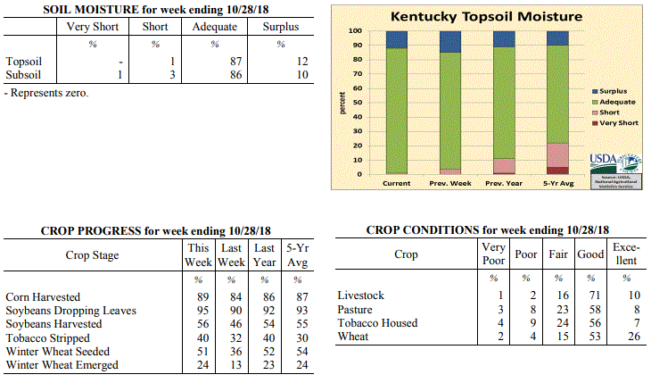
Kentucky Crop and Weather Report
Issued 4:00 P.M., October 29, 2018 35-18
Agricultural News: Kentucky experienced below normal temperatures and rainfall over
the past week. Precipitation for the week totaled 0.47 inches, 0.25 inches below
normal. Temperatures averaged 48 degrees for the week, 8 degrees below normal.
Topsoil moisture was rated 1 percent short, 87 percent adequate, and 12 percent
surplus. Subsoil moisture was rated 1 percent very short, 3 percent short, 86 percent
adequate, and 10 percent surplus. Days suitable for fieldwork averaged 4.9 out of a
possible seven.
Primary activities for this week included continuing harvest of corn and soybeans,
stripping tobacco, and planting winter wheat. Scattered precipitation and seasonably
cool temperatures hampered field work to a degree, however farmers were able to push
ahead.
Livestock and pasture condition is mostly good at this time despite cool temperatures
and wet weather. Housed tobacco is also in mostly good condition at this juncture.
Kentucky Climate Summary
For the Period October 29 to November 4, 2018
Near Normal Temperatures and Above Normal Rainfall:
The period started with near perfect weather in place as high pressure slowly worked
across the area. This feature provided dry weather, mostly sunny skies, and warming
temperatures, peaking in the upper 60s to middle 70s on Tuesday. Conditions
deteriorated on Halloween and the first day of November as a cold front was very slow
to work through the region. Widespread rains fell across the Commonwealth, but the
majority of the soaking rainfall fell across Western Kentucky and areas northeast up
into the Bluegrass. Many in this area saw 2 to 4+ inches for the week. Areas to the
southeast missed out on much of the rainfall as the boundary stalled and only
averaged a quarter to 1 inch for the week. Additional rain fell Friday and Sunday, but
with much less in the way of any accumulations.
Temperatures for the period averaged 53 degrees across the state which was near
normal and 2 degrees warmer than the previous period. High temperatures
averaged from 63 in the West to 63 in the East. Departure from normal high
temperatures ranged from 2 degrees cooler than normal in the West to 2 degrees
cooler than normal in the East. Low temperatures averaged from 45 degrees in the
West to 43 degrees in the East. Departure from normal low temperature ranged from 2
degrees warmer than normal in the West to 5 degrees warmer than normal in the East.
The extreme high temperature for the period was 80 degrees at PADUCAH ASOS and the
extreme low was 30 degrees at CAMPBELLSVILLE 7W.
Precipitation (liq. equ.) for the period totaled 1.64 inches statewide which was 0.88
inches above normal and 215% of normal. Precipitation totals by climate division,
West 3.20 inches, Central 1.28 inches, Bluegrass 1.75 inches and East 0.34 inches,
which was 2.35, 0.49, 1.05 and -0.37 inches respectively from normal. By station,
precipitation totals ranged from a low of 0.07 inches at PAINTSVILLE 4W to a high of
5.18 inches at PADUCAH ASOS.
---
Kentucky Crop and Weather Report
Issued 4:00 P.M., October 29, 2018 35-18
Agricultural News: Kentucky experienced below normal temperatures and rainfall over
the past week. Precipitation for the week totaled 0.47 inches, 0.25 inches below
normal. Temperatures averaged 48 degrees for the week, 8 degrees below normal.
Topsoil moisture was rated 1 percent short, 87 percent adequate, and 12 percent
surplus. Subsoil moisture was rated 1 percent very short, 3 percent short, 86 percent
adequate, and 10 percent surplus. Days suitable for fieldwork averaged 4.9 out of a
possible seven.
Primary activities for this week included continuing harvest of corn and soybeans,
stripping tobacco, and planting winter wheat. Scattered precipitation and seasonably
cool temperatures hampered field work to a degree, however farmers were able to push
ahead.
Livestock and pasture condition is mostly good at this time despite cool temperatures
and wet weather. Housed tobacco is also in mostly good condition at this juncture.
 Kentucky Climate Summary
For the Period October 22 to October 28, 2018
Below Normal Temperatures and Rainfall:
Cool conditions pushed Kentucky to a second straight week of below normal
temperatures. The cold was most noteworthy Monday morning as the majority of state
dropped below freezing, into the upper 20s to low 30s. The first half of the workweek
remained dry, but an area of low pressure sparked widespread light showers Thursday
night and into Friday. Scattered coverage remained on Saturday, before a final round
on Sunday with the passage of a cold front. All together, the state averaged about a
half inch, a bit less across Western Kentucky and more so across Eastern Kentucky. The
frontal passage to end the period was accompanied by another round of high winds with
gusts in excess of 40 mph at times.
Temperatures for the period averaged 48 degrees across the state which was 8 degrees
cooler than normal and 4 degrees cooler than the previous period. High temperatures
averaged from 60 in the West to 57 in the East. Departure from normal high
temperatures ranged from 9 degrees cooler than normal in the West to 11 degrees
cooler than normal in the East. Low temperatures averaged from 40 degrees in the
West to 38 degrees in the East. Departure from normal low temperature ranged from 5
degrees cooler than normal in the West to 2 degrees cooler than normal in the East.
The extreme high temperature for the period was 74 degrees at PADUCAH ASOS and the
extreme low was 26 degrees at HENDERSON 5E.
Precipitation (liq. equ.) for the period totaled 0.47 inches statewide which was 0.25
inches below normal and 66% of normal. Precipitation totals by climate division, West
0.31 inches, Central 0.49 inches, Bluegrass 0.43 inches and East 0.66 inches, which
was 0.49, 0.23, 0.23 and 0.02 inches below normal. By station, precipitation totals
ranged from a low of 0.17 inches at OWENSBORO AWSS to a high of 1.24 inches at
WHITLEY CITY 3N.
---
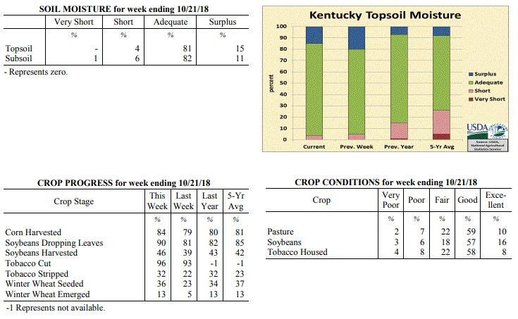
Kentucky Crop and Weather Report
Issued 4:00 P.M., October 22, 2018 34-18
Agricultural News: Kentucky experienced below normal temperatures and above normal
rainfall over the past week. Precipitation for the week totaled 1.06 inches, 0.36
inches above normal. Temperatures averaged 50 degrees for the week, 7 degrees below
normal. Topsoil moisture was rated 4 percent short, 81 percent adequate, and 15
percent surplus. Subsoil moisture was rated 1 percent very short, 6 percent short, 82
percent adequate, and 11 percent surplus. Days suitable for fieldwork averaged 4.3
out of a possible seven.
Primary activities for this week included harvesting corn and soybeans, stripping
tobacco, and planting winter wheat. Cool temperatures and some scattered rain
hindered fieldwork at times, however harvest continues to progress.
Pasture condition is mostly good at this time with cooler temperatures and light
frost slowing growth. Soybeans and housed tobacco were both reported as in mostly
good condition.
Kentucky Climate Summary
For the Period October 22 to October 28, 2018
Below Normal Temperatures and Rainfall:
Cool conditions pushed Kentucky to a second straight week of below normal
temperatures. The cold was most noteworthy Monday morning as the majority of state
dropped below freezing, into the upper 20s to low 30s. The first half of the workweek
remained dry, but an area of low pressure sparked widespread light showers Thursday
night and into Friday. Scattered coverage remained on Saturday, before a final round
on Sunday with the passage of a cold front. All together, the state averaged about a
half inch, a bit less across Western Kentucky and more so across Eastern Kentucky. The
frontal passage to end the period was accompanied by another round of high winds with
gusts in excess of 40 mph at times.
Temperatures for the period averaged 48 degrees across the state which was 8 degrees
cooler than normal and 4 degrees cooler than the previous period. High temperatures
averaged from 60 in the West to 57 in the East. Departure from normal high
temperatures ranged from 9 degrees cooler than normal in the West to 11 degrees
cooler than normal in the East. Low temperatures averaged from 40 degrees in the
West to 38 degrees in the East. Departure from normal low temperature ranged from 5
degrees cooler than normal in the West to 2 degrees cooler than normal in the East.
The extreme high temperature for the period was 74 degrees at PADUCAH ASOS and the
extreme low was 26 degrees at HENDERSON 5E.
Precipitation (liq. equ.) for the period totaled 0.47 inches statewide which was 0.25
inches below normal and 66% of normal. Precipitation totals by climate division, West
0.31 inches, Central 0.49 inches, Bluegrass 0.43 inches and East 0.66 inches, which
was 0.49, 0.23, 0.23 and 0.02 inches below normal. By station, precipitation totals
ranged from a low of 0.17 inches at OWENSBORO AWSS to a high of 1.24 inches at
WHITLEY CITY 3N.
---
Kentucky Crop and Weather Report
Issued 4:00 P.M., October 22, 2018 34-18
Agricultural News: Kentucky experienced below normal temperatures and above normal
rainfall over the past week. Precipitation for the week totaled 1.06 inches, 0.36
inches above normal. Temperatures averaged 50 degrees for the week, 7 degrees below
normal. Topsoil moisture was rated 4 percent short, 81 percent adequate, and 15
percent surplus. Subsoil moisture was rated 1 percent very short, 6 percent short, 82
percent adequate, and 11 percent surplus. Days suitable for fieldwork averaged 4.3
out of a possible seven.
Primary activities for this week included harvesting corn and soybeans, stripping
tobacco, and planting winter wheat. Cool temperatures and some scattered rain
hindered fieldwork at times, however harvest continues to progress.
Pasture condition is mostly good at this time with cooler temperatures and light
frost slowing growth. Soybeans and housed tobacco were both reported as in mostly
good condition.
 Kentucky Climate Summary
For the Period October 15 to October 21, 2018
Below Normal Temperatures and Above Normal Rainfall:
The passage of multiple cold fronts kept a cooler air mass situated over the
Bluegrass State for much of the period. Frost Advisories and Freeze Warnings were
issued on multiple occasions. Most of the state saw extreme low temperatures drop
into the upper 20s to middle 30s at some point over the past week. This was
especially the case Saturday night, behind the passage of a strong cold front. This
frontal boundary was the focus for high winds late Saturday with gusts in excess of
40 mph at times. Overall, the state average temperature for the week was 7 degrees
below normal, which broke a seven week streak of above normal temperatures.
Precipitation averaged about an inch with a couple widespread rounds of light to
moderate showers, one coming on Monday and the other on Friday, carring over into
the early stages of Saturday.
Temperatures for the period averaged 50 degrees across the state which was 7 degrees
cooler than normal and 12 degrees cooler than the previous period. High temperatures
averaged from 61 in the West to 60 in the East. Departure from normal high
temperatures ranged from 10 degrees cooler than normal in the West to 10 degrees
cooler than normal in the East. Low temperatures averaged from 40 degrees in the
West to 43 degrees in the East. Departure from normal low temperature ranged from 6
degrees cooler than normal in the West to 1 degree warmer than normal in the East.
The extreme high temperature for the period was 74 degrees at BURKESVILLE 3W and the
extreme low was 26 degrees at HENDERSON 5E.
Precipitation (liq. equ.) for the period totaled 1.06 inches statewide which was 0.36
inches above normal and 151% of normal. Precipitation totals by climate division,
West 0.96 inches, Central 1.62 inches, Bluegrass 0.72 inches and East 0.94 inches,
which was 0.2, 0.91, 0.06 and 0.27 inches above normal. By station, precipitation
totals ranged from a low of 0.11 inches at CARROLLTON 2E to a high of 2.82 inches
at RUSSELLVILLE 2W.
---
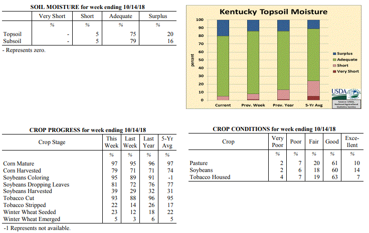
Kentucky Crop and Weather Report
Issued 4:00 P.M., October 15, 2018 33-18
Agricultural News: Kentucky experienced normal temperatures and rainfall over the
past week. Precipitation for the week totaled 0.80 inches, 0.06 inches above normal.
Temperatures averaged 62 degrees for the week, 3 degrees above normal. Topsoil
moisture was rated 5 percent short, 75 percent adequate, and 20 percent surplus.
Subsoil moisture was rated 5 percent short, 79 percent adequate, and 16 percent
surplus. Days suitable for fieldwork averaged 4.8 out of a possible seven.
Primary activities for this week included the continued harvest of corn, soybeans,
and tobacco along with winter wheat planting and tobacco stripping. While
temperatures were seasonably cool as the week progressed, scattered rain interrupted
fieldwork at times.
Pasture condition is mostly good at this time with cooler temperatures slowing
growth. The condition of housed tobacco was reported as mostly good as were soybeans.
Although the majority of winter wheat is yet to be planted, a small portion
of the crop has begun to emerge.
Kentucky Climate Summary
For the Period October 15 to October 21, 2018
Below Normal Temperatures and Above Normal Rainfall:
The passage of multiple cold fronts kept a cooler air mass situated over the
Bluegrass State for much of the period. Frost Advisories and Freeze Warnings were
issued on multiple occasions. Most of the state saw extreme low temperatures drop
into the upper 20s to middle 30s at some point over the past week. This was
especially the case Saturday night, behind the passage of a strong cold front. This
frontal boundary was the focus for high winds late Saturday with gusts in excess of
40 mph at times. Overall, the state average temperature for the week was 7 degrees
below normal, which broke a seven week streak of above normal temperatures.
Precipitation averaged about an inch with a couple widespread rounds of light to
moderate showers, one coming on Monday and the other on Friday, carring over into
the early stages of Saturday.
Temperatures for the period averaged 50 degrees across the state which was 7 degrees
cooler than normal and 12 degrees cooler than the previous period. High temperatures
averaged from 61 in the West to 60 in the East. Departure from normal high
temperatures ranged from 10 degrees cooler than normal in the West to 10 degrees
cooler than normal in the East. Low temperatures averaged from 40 degrees in the
West to 43 degrees in the East. Departure from normal low temperature ranged from 6
degrees cooler than normal in the West to 1 degree warmer than normal in the East.
The extreme high temperature for the period was 74 degrees at BURKESVILLE 3W and the
extreme low was 26 degrees at HENDERSON 5E.
Precipitation (liq. equ.) for the period totaled 1.06 inches statewide which was 0.36
inches above normal and 151% of normal. Precipitation totals by climate division,
West 0.96 inches, Central 1.62 inches, Bluegrass 0.72 inches and East 0.94 inches,
which was 0.2, 0.91, 0.06 and 0.27 inches above normal. By station, precipitation
totals ranged from a low of 0.11 inches at CARROLLTON 2E to a high of 2.82 inches
at RUSSELLVILLE 2W.
---
Kentucky Crop and Weather Report
Issued 4:00 P.M., October 15, 2018 33-18
Agricultural News: Kentucky experienced normal temperatures and rainfall over the
past week. Precipitation for the week totaled 0.80 inches, 0.06 inches above normal.
Temperatures averaged 62 degrees for the week, 3 degrees above normal. Topsoil
moisture was rated 5 percent short, 75 percent adequate, and 20 percent surplus.
Subsoil moisture was rated 5 percent short, 79 percent adequate, and 16 percent
surplus. Days suitable for fieldwork averaged 4.8 out of a possible seven.
Primary activities for this week included the continued harvest of corn, soybeans,
and tobacco along with winter wheat planting and tobacco stripping. While
temperatures were seasonably cool as the week progressed, scattered rain interrupted
fieldwork at times.
Pasture condition is mostly good at this time with cooler temperatures slowing
growth. The condition of housed tobacco was reported as mostly good as were soybeans.
Although the majority of winter wheat is yet to be planted, a small portion
of the crop has begun to emerge.
 Kentucky Climate Summary
For the Period October 8 to October 14, 2018
Above Normal Temperatures and Rainfall:
The transitional season of fall to cooler weather was in full effect this period. The
week started with unseasonably warm temperatures and mostly dry conditions in place.
High temperatures jumped into the mid to upper 80s on Monday and Tuesday, before a
strong cold front pushed through the area on Wednesday. The boundary was the focus
for periods of showers through the day, but the bigger story was an abrupt change to
fall weather. Behind the front, northwest flow ushered much cooler and drier air into
the Bluegrass State for the second half of the week. Low temperatures dropped into
the upper 30s to middle 40s both Friday and Saturday mornings. Even had some spots drop
into the middle 30s. Additional disturbances moved through the area over the weekend,
sparking light to occasionally moderate showers. Overall, the state averaged 0.80
inches for the week, which was slightly above normal for this time of year.
Temperatures for the period averaged 62 degrees across the state which was 3 degrees
warmer than normal and 14 degrees cooler than the previous period. High temperatures
averaged from 70 in the West to 70 in the East. Departure from normal high
temperatures ranged from 4 degrees cooler than normal in the West to 1 degree
cooler than normal in the East. Low temperatures averaged from 56 degrees in the
West to 54 degrees in the East. Departure from normal low temperature ranged from 8
degrees warmer than normal in the West to 10 degrees warmer than normal in the
East. The extreme high temperature for the period was 90 degrees at OWENSBORO AWSS
and the extreme low was 35 degrees at HENDERSON 5E.
Precipitation (liq. equ.) for the period totaled 0.80 inches statewide which was 0.06
inches above normal and 108% of normal. Precipitation totals by climate division,
West 0.79 inches, Central 0.80 inches, Bluegrass 0.70 inches and East 0.90 inches,
which was 0.04, 0.03, -0.01 and 0.16 inches respectively from normal. By station,
precipitation totals ranged from a low of 0.00 inches at MONTICELLO AWOS to a high of
2.18 inches at BURKESVILLE 3W.
---
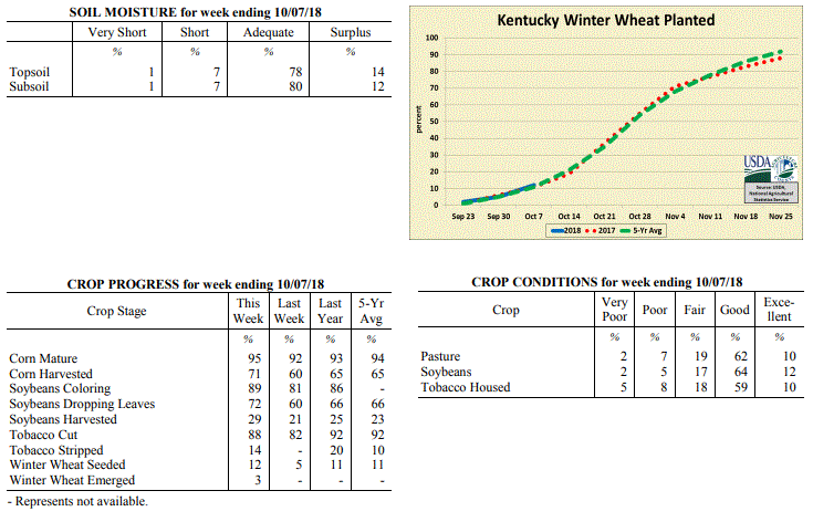
Kentucky Crop and Weather Report
Issued 4:00 P.M., October 8, 2018 32-18
Agricultural News: Kentucky experienced well above normal temperatures and below
normal rainfall over the past week. Precipitation for the week totaled 0.47 inches,
0.33 inches below normal. Temperatures averaged 76 degrees for the week, 14 degrees
above normal. Topsoil moisture was rated 1 percent very short, 7 percent short, 78
percent adequate, and 14 percent surplus. Subsoil moisture was rated 1 percent very
short, 7 percent short, 80 percent adequate, and 12 percent surplus. Days suitable
for fieldwork averaged 5.2 out of a possible seven.
Primary activities for this week included the ongoing harvest of corn, soybeans, and
tobacco. Winter wheat planting is continuing with a small percentage of the crop
beginning to emerge. For most of the state the weather was hot and dry allowing
farmers to move ahead with fieldwork.
Pasture condition is mostly good at this time, however the unseasonal heat may have a
negative effect going forward without some rain. Housed tobacco is in mostly good
condition with evident houseburn rated as 7 percent severe, 13 percent moderate, 29
percent light, and 51 percent with none.
Kentucky Climate Summary
For the Period October 8 to October 14, 2018
Above Normal Temperatures and Rainfall:
The transitional season of fall to cooler weather was in full effect this period. The
week started with unseasonably warm temperatures and mostly dry conditions in place.
High temperatures jumped into the mid to upper 80s on Monday and Tuesday, before a
strong cold front pushed through the area on Wednesday. The boundary was the focus
for periods of showers through the day, but the bigger story was an abrupt change to
fall weather. Behind the front, northwest flow ushered much cooler and drier air into
the Bluegrass State for the second half of the week. Low temperatures dropped into
the upper 30s to middle 40s both Friday and Saturday mornings. Even had some spots drop
into the middle 30s. Additional disturbances moved through the area over the weekend,
sparking light to occasionally moderate showers. Overall, the state averaged 0.80
inches for the week, which was slightly above normal for this time of year.
Temperatures for the period averaged 62 degrees across the state which was 3 degrees
warmer than normal and 14 degrees cooler than the previous period. High temperatures
averaged from 70 in the West to 70 in the East. Departure from normal high
temperatures ranged from 4 degrees cooler than normal in the West to 1 degree
cooler than normal in the East. Low temperatures averaged from 56 degrees in the
West to 54 degrees in the East. Departure from normal low temperature ranged from 8
degrees warmer than normal in the West to 10 degrees warmer than normal in the
East. The extreme high temperature for the period was 90 degrees at OWENSBORO AWSS
and the extreme low was 35 degrees at HENDERSON 5E.
Precipitation (liq. equ.) for the period totaled 0.80 inches statewide which was 0.06
inches above normal and 108% of normal. Precipitation totals by climate division,
West 0.79 inches, Central 0.80 inches, Bluegrass 0.70 inches and East 0.90 inches,
which was 0.04, 0.03, -0.01 and 0.16 inches respectively from normal. By station,
precipitation totals ranged from a low of 0.00 inches at MONTICELLO AWOS to a high of
2.18 inches at BURKESVILLE 3W.
---
Kentucky Crop and Weather Report
Issued 4:00 P.M., October 8, 2018 32-18
Agricultural News: Kentucky experienced well above normal temperatures and below
normal rainfall over the past week. Precipitation for the week totaled 0.47 inches,
0.33 inches below normal. Temperatures averaged 76 degrees for the week, 14 degrees
above normal. Topsoil moisture was rated 1 percent very short, 7 percent short, 78
percent adequate, and 14 percent surplus. Subsoil moisture was rated 1 percent very
short, 7 percent short, 80 percent adequate, and 12 percent surplus. Days suitable
for fieldwork averaged 5.2 out of a possible seven.
Primary activities for this week included the ongoing harvest of corn, soybeans, and
tobacco. Winter wheat planting is continuing with a small percentage of the crop
beginning to emerge. For most of the state the weather was hot and dry allowing
farmers to move ahead with fieldwork.
Pasture condition is mostly good at this time, however the unseasonal heat may have a
negative effect going forward without some rain. Housed tobacco is in mostly good
condition with evident houseburn rated as 7 percent severe, 13 percent moderate, 29
percent light, and 51 percent with none.
 Kentucky Climate Summary
For the Period October 1 to October 7, 2018
Well Above Normal Temperatures and Below Normal Rainfall:
Unseasonably warm and dry for much of the Bluegrass State over the past 7 days.
Showers and thunderstorms were mostly scattered at the start and midpoint of the
workweek. Then summer-like conditions provided very warm and muggy weather with only
isolated showers and thunderstorms for the remainder of the workweek and weekend.
Western Kentucky missed out on much of the rainfall and averaged less than a tenth of
an inch, while the rest of the state was around a half. Temperature-wise, highs
jumped into the upper 80s to low 90s at times across the state. Normal high
temperatures for the first week of October are in the low to middle 70s. Kentucky has
now seen six straight weeks of above normal temperatures.
Temperatures for the period averaged 76 degrees across the state which was 14 degrees
warmer than normal and 8 degrees warmer than the previous period. High temperatures
averaged from 88 in the West to 84 in the East. Departure from normal high
temperatures ranged from 12 degrees warmer than normal in the West to 10 degrees
warmer than normal in the East. Low temperatures averaged from 67 degrees in the
West to 65 degrees in the East. Departure from normal low temperature ranged from 16
degrees warmer than normal in the West to 18 degrees warmer than normal in the
East. The extreme high temperature for the period was 92 degrees at GREENVILLE 6N and
the extreme low was 54 degrees at CARBONDALE ASOS.
Precipitation (liq. equ.) for the period totaled 0.47 inches statewide which was 0.33
inches below normal and 59% of normal. Precipitation totals by climate division, West
0.09 inches, Central 0.48 inches, Bluegrass 0.65 inches and East 0.65 inches, which
was 0.73, 0.36, 0.09 and 0.14 inches below normal. By station, precipitation totals
ranged from a low of 0.00 inches at BARBOURVILLE 3E to a high of 3.88 inches at
LEXINGTON APT.
---
Kentucky Crop and Weather Report
Issued 4:00 P.M., October 1, 2018 31-18
Agricultural News: Kentucky experienced above normal temperatures and well above
normal rainfall over the past week. Precipitation for the week totaled 2.58 inches,
1.74 inches above normal. Temperatures averaged 67 degrees for the week, 2 degrees
above normal. Topsoil moisture was rated 3 percent short, 62 percent adequate, and 35
percent surplus. Subsoil moisture was rated 1 percent very short, 5 percent short, 66
percent adequate, and 28 percent surplus. Days suitable for fieldwork averaged 2.4
out of a possible seven.
Primary activities for this week included the continued harvest of tobacco, corn,
soybeans, and hay along with the early stages of winter wheat planting. Although
fieldwork was limited in the early part of the week due to precipitation, the latter
part of the week presented favorable conditions. Rain was very heavy in areas of the
state leading to the flooding of some fields, however crop damage does not appear to
be widespread. Crop conditions and disease possibility will be monitored carefully as
fields begin to dry.
Livestock and pasture conditions are mostly good at this time despite the heavy rain.
Hay supplies were reported as 3 percent very short, 17 percent short, 70 percent
adequate, and 10 percent surplus. Tobacco houseburn was reported as 4 percent severe,
12 percent moderate, 32 percent light, and 52 percent experiencing none.
Kentucky Climate Summary
For the Period October 1 to October 7, 2018
Well Above Normal Temperatures and Below Normal Rainfall:
Unseasonably warm and dry for much of the Bluegrass State over the past 7 days.
Showers and thunderstorms were mostly scattered at the start and midpoint of the
workweek. Then summer-like conditions provided very warm and muggy weather with only
isolated showers and thunderstorms for the remainder of the workweek and weekend.
Western Kentucky missed out on much of the rainfall and averaged less than a tenth of
an inch, while the rest of the state was around a half. Temperature-wise, highs
jumped into the upper 80s to low 90s at times across the state. Normal high
temperatures for the first week of October are in the low to middle 70s. Kentucky has
now seen six straight weeks of above normal temperatures.
Temperatures for the period averaged 76 degrees across the state which was 14 degrees
warmer than normal and 8 degrees warmer than the previous period. High temperatures
averaged from 88 in the West to 84 in the East. Departure from normal high
temperatures ranged from 12 degrees warmer than normal in the West to 10 degrees
warmer than normal in the East. Low temperatures averaged from 67 degrees in the
West to 65 degrees in the East. Departure from normal low temperature ranged from 16
degrees warmer than normal in the West to 18 degrees warmer than normal in the
East. The extreme high temperature for the period was 92 degrees at GREENVILLE 6N and
the extreme low was 54 degrees at CARBONDALE ASOS.
Precipitation (liq. equ.) for the period totaled 0.47 inches statewide which was 0.33
inches below normal and 59% of normal. Precipitation totals by climate division, West
0.09 inches, Central 0.48 inches, Bluegrass 0.65 inches and East 0.65 inches, which
was 0.73, 0.36, 0.09 and 0.14 inches below normal. By station, precipitation totals
ranged from a low of 0.00 inches at BARBOURVILLE 3E to a high of 3.88 inches at
LEXINGTON APT.
---
Kentucky Crop and Weather Report
Issued 4:00 P.M., October 1, 2018 31-18
Agricultural News: Kentucky experienced above normal temperatures and well above
normal rainfall over the past week. Precipitation for the week totaled 2.58 inches,
1.74 inches above normal. Temperatures averaged 67 degrees for the week, 2 degrees
above normal. Topsoil moisture was rated 3 percent short, 62 percent adequate, and 35
percent surplus. Subsoil moisture was rated 1 percent very short, 5 percent short, 66
percent adequate, and 28 percent surplus. Days suitable for fieldwork averaged 2.4
out of a possible seven.
Primary activities for this week included the continued harvest of tobacco, corn,
soybeans, and hay along with the early stages of winter wheat planting. Although
fieldwork was limited in the early part of the week due to precipitation, the latter
part of the week presented favorable conditions. Rain was very heavy in areas of the
state leading to the flooding of some fields, however crop damage does not appear to
be widespread. Crop conditions and disease possibility will be monitored carefully as
fields begin to dry.
Livestock and pasture conditions are mostly good at this time despite the heavy rain.
Hay supplies were reported as 3 percent very short, 17 percent short, 70 percent
adequate, and 10 percent surplus. Tobacco houseburn was reported as 4 percent severe,
12 percent moderate, 32 percent light, and 52 percent experiencing none.
 Kentucky Climate Summary
For the Period September 24 to September 30, 2018
Above Normal Temperatures and Well Above Normal Rainfall:
Carrying over from the previous weekend, a wet pattern continued through Thursday
with daily showers and some storms. A combination of frontal passages and
disturbances aloft sparked this activity within a very moist air mass. Rainfall was
widespread at times and did aggravate ongoing flooding issues from the weekend before
with already saturated grounds for many locations. A week after averaging 2.19
inches, the Commonwealth turned around and averaged another 2.58 inches. Preliminary
data from the Ag Weather Center suggest September 2018 will place in the top 5
wettest September’s on record for the state of Kentucky. Following the passage of a
disturbance aloft on Thursday, dry conditions and seasonable temperatures worked into
the area for the remainder of the period.
Temperatures for the period averaged 67 degrees across the state which was 2 degrees
warmer than normal and 8 degrees cooler than the previous period. High temperatures
averaged from 76 in the West to 74 in the East. Departure from normal high
temperatures ranged from 2 degrees cooler than normal in the West to 2 degrees
cooler than normal in the East. Low temperatures averaged from 60 degrees in the
West to 60 degrees in the East. Departure from normal low temperature ranged from 6
degrees warmer than normal in the West to 9 degrees warmer than normal in the East.
The extreme high temperature for the period was 86 degrees at PADUCAH ASOS and the
extreme low was 45 degrees at CINCINNATI.
Precipitation (liq. equ.) for the period totaled 2.58 inches statewide which was 1.74
inches above normal and 306% of normal. Precipitation totals by climate division,
West 2.49 inches, Central 2.69 inches, Bluegrass 2.44 inches and East 2.69 inches,
which was 1.63, 1.77, 1.68 and 1.86 inches above normal. By station, precipitation
totals ranged from a low of 0.75 inches at OWENSBORO AWSS to a high of 4.21 inches at
YELLOW CREEK.
---
Kentucky Crop and Weather Report
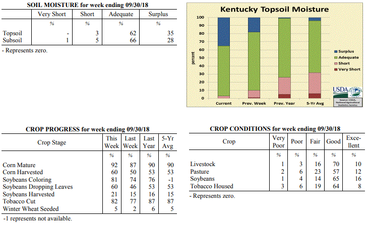
Issued 4:00 P.M., September 24, 2018 30-18
Agricultural News: Kentucky experienced above normal temperatures and well above
normal rainfall over the past week. Precipitation for the week totaled 2.19 inches,
1.36 inches above normal. Temperatures averaged 75 degrees for the week, 8 degrees
above normal. Topsoil moisture was rated 1 percent very short, 9 percent short, 72
percent adequate and 18 percent surplus. Subsoil moisture was rated 3 percent very
short, 11 percent short, 71 percent adequate, and 15 percent surplus. Days suitable
for fieldwork averaged 5.1 out of a possible seven.
Primary activities this week included harvesting corn, soybeans, tobacco, and hay.
Wet weather over most of the state from remnants of Florence delayed fieldwork at
times and made harvesting activities difficult. Northern and eastern counties that
have experienced higher precipitation totals over the season have some flooded fields
and are reporting increased disease pressure. Rainfall and higher temperatures this
week, as well as forecasted rain next week, have some tobacco producers concerned
over harvesting fields in time and house burn exposure.
Kentucky Climate Summary
For the Period September 24 to September 30, 2018
Above Normal Temperatures and Well Above Normal Rainfall:
Carrying over from the previous weekend, a wet pattern continued through Thursday
with daily showers and some storms. A combination of frontal passages and
disturbances aloft sparked this activity within a very moist air mass. Rainfall was
widespread at times and did aggravate ongoing flooding issues from the weekend before
with already saturated grounds for many locations. A week after averaging 2.19
inches, the Commonwealth turned around and averaged another 2.58 inches. Preliminary
data from the Ag Weather Center suggest September 2018 will place in the top 5
wettest September’s on record for the state of Kentucky. Following the passage of a
disturbance aloft on Thursday, dry conditions and seasonable temperatures worked into
the area for the remainder of the period.
Temperatures for the period averaged 67 degrees across the state which was 2 degrees
warmer than normal and 8 degrees cooler than the previous period. High temperatures
averaged from 76 in the West to 74 in the East. Departure from normal high
temperatures ranged from 2 degrees cooler than normal in the West to 2 degrees
cooler than normal in the East. Low temperatures averaged from 60 degrees in the
West to 60 degrees in the East. Departure from normal low temperature ranged from 6
degrees warmer than normal in the West to 9 degrees warmer than normal in the East.
The extreme high temperature for the period was 86 degrees at PADUCAH ASOS and the
extreme low was 45 degrees at CINCINNATI.
Precipitation (liq. equ.) for the period totaled 2.58 inches statewide which was 1.74
inches above normal and 306% of normal. Precipitation totals by climate division,
West 2.49 inches, Central 2.69 inches, Bluegrass 2.44 inches and East 2.69 inches,
which was 1.63, 1.77, 1.68 and 1.86 inches above normal. By station, precipitation
totals ranged from a low of 0.75 inches at OWENSBORO AWSS to a high of 4.21 inches at
YELLOW CREEK.
---
Kentucky Crop and Weather Report
Issued 4:00 P.M., September 24, 2018 30-18
Agricultural News: Kentucky experienced above normal temperatures and well above
normal rainfall over the past week. Precipitation for the week totaled 2.19 inches,
1.36 inches above normal. Temperatures averaged 75 degrees for the week, 8 degrees
above normal. Topsoil moisture was rated 1 percent very short, 9 percent short, 72
percent adequate and 18 percent surplus. Subsoil moisture was rated 3 percent very
short, 11 percent short, 71 percent adequate, and 15 percent surplus. Days suitable
for fieldwork averaged 5.1 out of a possible seven.
Primary activities this week included harvesting corn, soybeans, tobacco, and hay.
Wet weather over most of the state from remnants of Florence delayed fieldwork at
times and made harvesting activities difficult. Northern and eastern counties that
have experienced higher precipitation totals over the season have some flooded fields
and are reporting increased disease pressure. Rainfall and higher temperatures this
week, as well as forecasted rain next week, have some tobacco producers concerned
over harvesting fields in time and house burn exposure.
 Kentucky Climate Summary
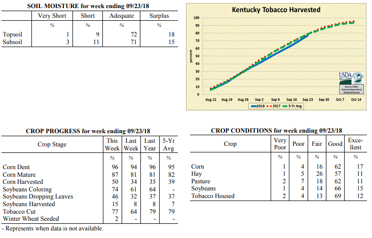
For the Period September 17 to September 23, 2018
Above Normal Temperatures and Well Above Normal Rainfall:
This past week added to an already wet month for the Bluegrass State. Starting
out, the remnant low of Florence drifted north across the eastern border of
Kentucky on Monday. Light to moderate showers continued to fall across primarily
the eastern half of the state, before the system moved out of the area that
night. Summer heat and isolated afternoon storms then returned the next few
days. Highs jumped into the low to middle 90s, much above normal highs of upper
70s to low 80s for this time of year. With that said, a strong cold front passed
through the area Friday and Friday night. Ahead and along the boundary,
thunderstorms developed within an unstable atmosphere, even forming a line at
one point, producing gusty winds and heavy rain. While cooler temperatures
arrived for the first day of fall on Saturday, the frontal passage signaled the
start of a very active weekend in which several rounds of showers pushed through
the state. Steady moderate showers even led to substantial flooding across
portions of the Southern Bluegrass and Northeast Kentucky. Overall, the state
averaged 1.75 inches over the past 3 days and 2.19 inches for the week.
Temperatures for the period averaged 75 degrees across the state which was 8
degrees warmer than normal and 4 degrees warmer than the previous period. High
temperatures averaged from 86 in the West to 81 in the East. Departure from
normal high temperatures ranged from 5 degrees warmer than normal in the West to
2 degrees warmer than normal in the East. Low temperatures averaged from 66
degrees in the West to 67 degrees in the East. Departure from normal low
temperature ranged from 9 degrees warmer than normal in the West to 13 degrees
warmer than normal in the East. The extreme high temperature for the period
was 99 degrees at MADISONVILLE 4S and the extreme low was 57 degrees at ALEXANDRIA
5NW.
Precipitation (liq. equ.) for the period totaled 2.19 inches statewide which was
1.36 inches above normal and 263% of normal. Precipitation totals by climate
division, West 1.48 inches, Central 2.29 inches, Bluegrass 2.46 inches and East
2.52 inches, which was 0.63, 1.38, 1.71 and 1.7 inches above normal. By station,
precipitation totals ranged from a low of 0.29 inches at EVANSVILLE ASOS to a
high of 5.20 inches at MUNFORDVILLE 6E.
---
Kentucky Crop and Weather Report
Issued 4:00 P.M., September 17, 2018 29-18
Agricultural News: Kentucky experienced above normal temperatures and below normal
rainfall over the past week. Precipitation for the week totaled 0.16 inches, 0.68
inches below normal. Temperatures averaged 72 degrees for the week, 2 degrees above
normal. Topsoil moisture was rated 3 percent very short, 14 percent short, 68 percent
adequate and 15 percent surplus. Subsoil moisture was rated 3 percent very short, 15
percent short, 72 percent adequate, and 10 percent surplus. Days suitable for
fieldwork averaged 5.4 out of a possible seven.
Primary activities this week included harvesting corn and soybeans, making hay, and
cutting tobacco. Several tobacco producers have noted that finding labor for
harvesting is an ongoing challenge. Northeastern counties experienced heavy rain
showers and humidity at times, leading to house burn in curing tobacco. Cattle
producers are preparing for fall breeding and securing supplies.
Kentucky Climate Summary
For the Period September 17 to September 23, 2018
Above Normal Temperatures and Well Above Normal Rainfall:
This past week added to an already wet month for the Bluegrass State. Starting
out, the remnant low of Florence drifted north across the eastern border of
Kentucky on Monday. Light to moderate showers continued to fall across primarily
the eastern half of the state, before the system moved out of the area that
night. Summer heat and isolated afternoon storms then returned the next few
days. Highs jumped into the low to middle 90s, much above normal highs of upper
70s to low 80s for this time of year. With that said, a strong cold front passed
through the area Friday and Friday night. Ahead and along the boundary,
thunderstorms developed within an unstable atmosphere, even forming a line at
one point, producing gusty winds and heavy rain. While cooler temperatures
arrived for the first day of fall on Saturday, the frontal passage signaled the
start of a very active weekend in which several rounds of showers pushed through
the state. Steady moderate showers even led to substantial flooding across
portions of the Southern Bluegrass and Northeast Kentucky. Overall, the state
averaged 1.75 inches over the past 3 days and 2.19 inches for the week.
Temperatures for the period averaged 75 degrees across the state which was 8
degrees warmer than normal and 4 degrees warmer than the previous period. High
temperatures averaged from 86 in the West to 81 in the East. Departure from
normal high temperatures ranged from 5 degrees warmer than normal in the West to
2 degrees warmer than normal in the East. Low temperatures averaged from 66
degrees in the West to 67 degrees in the East. Departure from normal low
temperature ranged from 9 degrees warmer than normal in the West to 13 degrees
warmer than normal in the East. The extreme high temperature for the period
was 99 degrees at MADISONVILLE 4S and the extreme low was 57 degrees at ALEXANDRIA
5NW.
Precipitation (liq. equ.) for the period totaled 2.19 inches statewide which was
1.36 inches above normal and 263% of normal. Precipitation totals by climate
division, West 1.48 inches, Central 2.29 inches, Bluegrass 2.46 inches and East
2.52 inches, which was 0.63, 1.38, 1.71 and 1.7 inches above normal. By station,
precipitation totals ranged from a low of 0.29 inches at EVANSVILLE ASOS to a
high of 5.20 inches at MUNFORDVILLE 6E.
---
Kentucky Crop and Weather Report
Issued 4:00 P.M., September 17, 2018 29-18
Agricultural News: Kentucky experienced above normal temperatures and below normal
rainfall over the past week. Precipitation for the week totaled 0.16 inches, 0.68
inches below normal. Temperatures averaged 72 degrees for the week, 2 degrees above
normal. Topsoil moisture was rated 3 percent very short, 14 percent short, 68 percent
adequate and 15 percent surplus. Subsoil moisture was rated 3 percent very short, 15
percent short, 72 percent adequate, and 10 percent surplus. Days suitable for
fieldwork averaged 5.4 out of a possible seven.
Primary activities this week included harvesting corn and soybeans, making hay, and
cutting tobacco. Several tobacco producers have noted that finding labor for
harvesting is an ongoing challenge. Northeastern counties experienced heavy rain
showers and humidity at times, leading to house burn in curing tobacco. Cattle
producers are preparing for fall breeding and securing supplies.
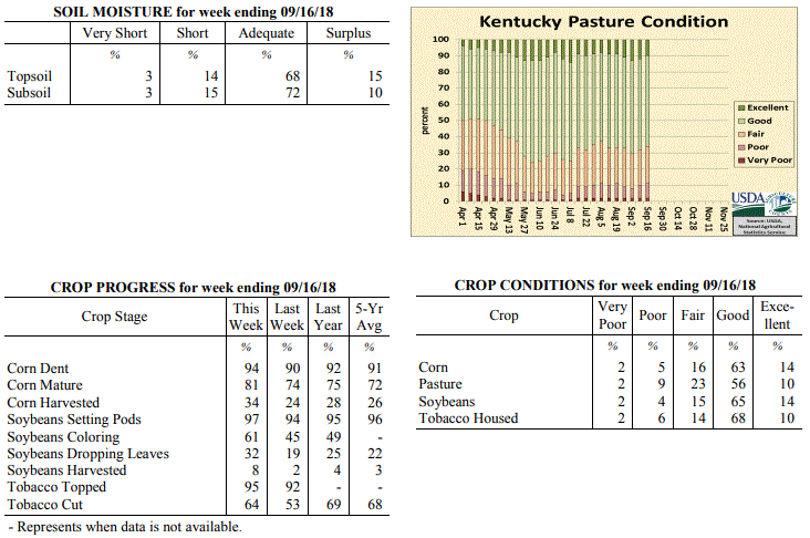 Kentucky Climate Summary
For the Period September 10 to September 16, 2018
Above Normal Temperatures and Below Normal Rainfall:
Tropical Depression Florence started working through Kentucky over the latter half of
the weekend. This became the third tropical system to make an appearance across the
Commonwealth this year, along with remnants of Alberto and Gordon. Light to
occasionally moderate showers associated with Florence were mainly confined to the
eastern half of the state and for many, was the only precipitation seen for the week.
While Eastern Kentucky averaged just over a half inch for the period, Western and
Central Kentucky did not receive any significant rainfall. Most across this area
either did not see accumulations or totals were below a tenth of an inch.
Temperatures for the period averaged 72 degrees across the state which was 2 degrees
warmer than normal and 6 degrees cooler than the previous period. High temperatures
averaged from 83 in the West to 80 in the East. Departure from normal high
temperatures ranged from near normal in the West to 1 degree cooler than
normal in the East. Low temperatures averaged from 62 degrees in the West to 65
degrees in the East. Departure from normal low temperature ranged from 2 degrees
warmer than normal in the West to 8 degrees warmer than normal in the East. The
extreme high temperature for the period was 95 degrees at MADISONVILLE 4S and the
extreme low was 52 degrees at CALHOUN 5NW.
Precipitation (liq. equ.) for the period totaled 0.16 inches statewide which was 0.68
inches below normal and 19% of normal. Precipitation totals by climate division, West
0.01 inches, Central 0.03 inches, Bluegrass 0.06 inches and East 0.54 inches, which
was 0.85, 0.91, 0.7 and 0.28 inches below normal. By station, precipitation totals
ranged from a low of 0.00 inches at BENTON 4N to a high of 1.36 inches at MIDDLESBORO AWOS.
---
Kentucky Crop and Weather Report
Issued 4:00 P.M., September 10, 2018 28-18
Agricultural News: Kentucky experienced above normal temperatures and much above
normal rainfall over the past week. Precipitation for the week totaled 2.52 inches,
1.74 inches above normal. Temperatures averaged 78 degrees for the week, 6 degrees
above normal. Topsoil moisture was rated 3 percent very short, 14 percent short, 71
percent adequate and 12 percent surplus. Subsoil moisture was rated 4 percent very
short, 15 percent short, 70 percent adequate, and 11 percent surplus. Days suitable
for fieldwork averaged 5.1 out of a possible seven.
Primary activities this week included harvesting corn, and cutting hay and tobacco.
Heavy rain later in the week and over the weekend from remnants of Tropical Storm
Gordon led to minor flooding; rains were mostly absorbed into the soil from past dry
weather. Fieldwork was delayed towards the end of the week, as farmers held off on
harvesting crops. Recent wet weather has tobacco producers concerned over house burn
and curing conditions. Excessive rainfall in areas has increased weed pressures in
fields and pastures.
Kentucky Climate Summary
For the Period September 10 to September 16, 2018
Above Normal Temperatures and Below Normal Rainfall:
Tropical Depression Florence started working through Kentucky over the latter half of
the weekend. This became the third tropical system to make an appearance across the
Commonwealth this year, along with remnants of Alberto and Gordon. Light to
occasionally moderate showers associated with Florence were mainly confined to the
eastern half of the state and for many, was the only precipitation seen for the week.
While Eastern Kentucky averaged just over a half inch for the period, Western and
Central Kentucky did not receive any significant rainfall. Most across this area
either did not see accumulations or totals were below a tenth of an inch.
Temperatures for the period averaged 72 degrees across the state which was 2 degrees
warmer than normal and 6 degrees cooler than the previous period. High temperatures
averaged from 83 in the West to 80 in the East. Departure from normal high
temperatures ranged from near normal in the West to 1 degree cooler than
normal in the East. Low temperatures averaged from 62 degrees in the West to 65
degrees in the East. Departure from normal low temperature ranged from 2 degrees
warmer than normal in the West to 8 degrees warmer than normal in the East. The
extreme high temperature for the period was 95 degrees at MADISONVILLE 4S and the
extreme low was 52 degrees at CALHOUN 5NW.
Precipitation (liq. equ.) for the period totaled 0.16 inches statewide which was 0.68
inches below normal and 19% of normal. Precipitation totals by climate division, West
0.01 inches, Central 0.03 inches, Bluegrass 0.06 inches and East 0.54 inches, which
was 0.85, 0.91, 0.7 and 0.28 inches below normal. By station, precipitation totals
ranged from a low of 0.00 inches at BENTON 4N to a high of 1.36 inches at MIDDLESBORO AWOS.
---
Kentucky Crop and Weather Report
Issued 4:00 P.M., September 10, 2018 28-18
Agricultural News: Kentucky experienced above normal temperatures and much above
normal rainfall over the past week. Precipitation for the week totaled 2.52 inches,
1.74 inches above normal. Temperatures averaged 78 degrees for the week, 6 degrees
above normal. Topsoil moisture was rated 3 percent very short, 14 percent short, 71
percent adequate and 12 percent surplus. Subsoil moisture was rated 4 percent very
short, 15 percent short, 70 percent adequate, and 11 percent surplus. Days suitable
for fieldwork averaged 5.1 out of a possible seven.
Primary activities this week included harvesting corn, and cutting hay and tobacco.
Heavy rain later in the week and over the weekend from remnants of Tropical Storm
Gordon led to minor flooding; rains were mostly absorbed into the soil from past dry
weather. Fieldwork was delayed towards the end of the week, as farmers held off on
harvesting crops. Recent wet weather has tobacco producers concerned over house burn
and curing conditions. Excessive rainfall in areas has increased weed pressures in
fields and pastures.
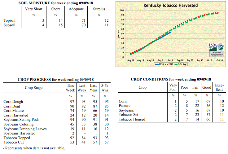 Kentucky Climate Summary
For the Period September 3 to September 9, 2018
Above Normal Temperatures and Much Above Normal Rainfall:
The remnants of Tropical Storm Gordon left much of the state wet and soggy this past
period. The system started impacting the area on Wednesday as tropical moisture was
pulled northward into the Ohio Valley. While showers and storms were scattered in
nature on Wednesday and Thursday, coverage grew upscale Friday and over the weekend
as the remnant system slowly worked across the area. The abundance of rainfall and
high intensity at times led to several bouts of flash flooding and even sent some
rivers into minor flood stages. While the state averaged a little over 2.5 inches
for the week, much higher totals were seen across counties bordering the Ohio River,
in addition to Northeastern Kentucky. Many were over 4 inches. Temperature-wise,
above normal temperatures and high humidity continued over the first half of the week
with highs jumping into the low to middle 90s. Saying that, cloud cover and rainfall
from Gordon brought temperatures back below seasonable norms by the end of the week
with highs on Sunday only in the 60s and 70s.
Temperatures for the period averaged 78 degrees across the state which was 6 degrees
warmer than normal and no change to the previous period. High temperatures averaged
from 87 in the West to 87 in the East. Departure from normal high temperatures
ranged from 1 degree warmer than normal in the West to 3 degrees warmer than normal
in the East. Low temperatures averaged from 69 degrees in the West to 69 degrees in
the East. Departure from normal low temperature ranged from 7 degrees warmer than
normal in the West to 10 degrees warmer than normal in the East. The extreme high
temperature for the period was 98 degrees at GREENVILLE 6N and the extreme low was 57
degrees at ALEXANDRIA 5NW.
Precipitation (liq. equ.) for the period totaled 2.52 inches statewide which was 1.74
inches above normal and 323% of normal. Precipitation totals by climate division,
West 1.88 inches, Central 1.68 inches, Bluegrass 4.60 inches and East 1.90 inches,
which was 1.14, 0.82, 3.87 and 1.11 inches above normal. By station, precipitation
totals ranged from a low of 0.03 inches at MONTICELLO AWOS to a high of 8.79 inches
at OWINGSVILLE 4S.
---
Kentucky Crop and Weather Report
Issued 4:00 P.M., September 4, 2018 27-18
Agricultural News: Kentucky experienced above normal temperatures and below normal
rainfall over the past week. Precipitation for the week totaled 0.67 inches, 0.07
inches below normal. Temperatures averaged 79 degrees for the week, 5 degrees above
normal. Topsoil moisture was rated 5 percent very short, 19 percent short, 71 percent
adequate and 5 percent surplus. Subsoil moisture was rated 5 percent very short, 21
percent short, 68 percent adequate, and 6 percent surplus. Days suitable for
fieldwork averaged 6.0 out of a possible seven.
Primary activities this week included harvesting corn and hay, topping and cutting
tobacco, and preparing equipment for upcoming harvests. Dry weather has helped in
drying down corn, but needed rainfall in western and central counties would improve
pastures, hay, and soybeans to fend off early signs of drought stress.
Kentucky Climate Summary
For the Period September 3 to September 9, 2018
Above Normal Temperatures and Much Above Normal Rainfall:
The remnants of Tropical Storm Gordon left much of the state wet and soggy this past
period. The system started impacting the area on Wednesday as tropical moisture was
pulled northward into the Ohio Valley. While showers and storms were scattered in
nature on Wednesday and Thursday, coverage grew upscale Friday and over the weekend
as the remnant system slowly worked across the area. The abundance of rainfall and
high intensity at times led to several bouts of flash flooding and even sent some
rivers into minor flood stages. While the state averaged a little over 2.5 inches
for the week, much higher totals were seen across counties bordering the Ohio River,
in addition to Northeastern Kentucky. Many were over 4 inches. Temperature-wise,
above normal temperatures and high humidity continued over the first half of the week
with highs jumping into the low to middle 90s. Saying that, cloud cover and rainfall
from Gordon brought temperatures back below seasonable norms by the end of the week
with highs on Sunday only in the 60s and 70s.
Temperatures for the period averaged 78 degrees across the state which was 6 degrees
warmer than normal and no change to the previous period. High temperatures averaged
from 87 in the West to 87 in the East. Departure from normal high temperatures
ranged from 1 degree warmer than normal in the West to 3 degrees warmer than normal
in the East. Low temperatures averaged from 69 degrees in the West to 69 degrees in
the East. Departure from normal low temperature ranged from 7 degrees warmer than
normal in the West to 10 degrees warmer than normal in the East. The extreme high
temperature for the period was 98 degrees at GREENVILLE 6N and the extreme low was 57
degrees at ALEXANDRIA 5NW.
Precipitation (liq. equ.) for the period totaled 2.52 inches statewide which was 1.74
inches above normal and 323% of normal. Precipitation totals by climate division,
West 1.88 inches, Central 1.68 inches, Bluegrass 4.60 inches and East 1.90 inches,
which was 1.14, 0.82, 3.87 and 1.11 inches above normal. By station, precipitation
totals ranged from a low of 0.03 inches at MONTICELLO AWOS to a high of 8.79 inches
at OWINGSVILLE 4S.
---
Kentucky Crop and Weather Report
Issued 4:00 P.M., September 4, 2018 27-18
Agricultural News: Kentucky experienced above normal temperatures and below normal
rainfall over the past week. Precipitation for the week totaled 0.67 inches, 0.07
inches below normal. Temperatures averaged 79 degrees for the week, 5 degrees above
normal. Topsoil moisture was rated 5 percent very short, 19 percent short, 71 percent
adequate and 5 percent surplus. Subsoil moisture was rated 5 percent very short, 21
percent short, 68 percent adequate, and 6 percent surplus. Days suitable for
fieldwork averaged 6.0 out of a possible seven.
Primary activities this week included harvesting corn and hay, topping and cutting
tobacco, and preparing equipment for upcoming harvests. Dry weather has helped in
drying down corn, but needed rainfall in western and central counties would improve
pastures, hay, and soybeans to fend off early signs of drought stress.
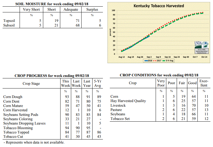 Kentucky Climate Summary
For the Period August 27 to September 2, 2018
Above Normal Temperatures and Below Normal Rainfall:
It may be the first week of September, but Kentucky saw some of the hottest
temperatures of the year over the period. The state average maximum temperature of
89 degrees for the week was only equaled one other time this year in early July.
The majority of Kentucky saw peak temperatures in the low to middle 90s at some
point. Normal high temperatures for early September run in the middle 80s. Combined
with no relief from the muggy conditions, heat indices continued to run close to 100
at times. Rainfall remained isolated to scattered throughout most of the week,
keeping some areas dry, while others saw torrential rainfall. Central Kentucky
and points east were around normal for the week, but Western Kentucky missed much of the
activity and only averaged 0.44 inches.
Temperatures for the period averaged 79 degrees across the state which was 5 degrees
warmer than normal and 6 degrees warmer than the previous period. High temperatures
averaged from 90 in the West to 88 in the East. Departure from normal high
temperatures ranged from 3 degrees warmer than normal in the West to 3 degrees
warmer than normal in the East. Low temperatures averaged from 70 degrees in the
West to 68 degrees in the East. Departure from normal low temperature ranged from 6
degrees warmer than normal in the West to 7 degrees warmer than normal in the East.
The extreme high temperature for the period was 98 degrees at MADISONVILLE 4S and the
extreme low was 63 degrees at MONTICELLO AWOS.
Precipitation (liq. equ.) for the period totaled 0.67 inches statewide which was 0.07
inches below normal and 91% of normal. Precipitation totals by climate division, West
0.44 inches, Central 0.73 inches, Bluegrass 0.67 inches and East 0.83 inches, which
was -0.23, -0.06, -0.06 and 0.06 inches respectively from normal. By station,
precipitation totals ranged from a low of 0.00 inches at EVANSVILLE ASOS to a high of
3.33 inches at HICKMAN 2E.
---
Kentucky Crop and Weather Report
Issued 4:00 P.M., August 27, 2018 26-18
Agricultural News: Kentucky experienced below normal temperatures and rainfall over
the past week. Precipitation for the week totaled 0.55 inches, 0.27 inches below
normal. Temperatures averaged 73 degrees for the week, 2 degrees below normal.
Topsoil moisture was rated 2 percent very short, 18 percent short, 73 percent
adequate, and 7 percent surplus. Subsoil moisture was rated 4 percent very short, 19
percent short, 70 percent adequate, and 7 percent surplus. Days suitable for
fieldwork averaged 5.4 out of a possible seven.
Primary activities for this week included cutting and topping tobacco along with
continued hay harvesting. Although fieldwork was limited at times due to scattered
rain, progress was evident. Corn harvest has begun, but is still in the initial
stage. Corn, soybeans, tobacco, and pasture remain in mostly good condition at this
juncture. Harvested hay was also reported as in mostly good condition.
Kentucky Climate Summary
For the Period August 27 to September 2, 2018
Above Normal Temperatures and Below Normal Rainfall:
It may be the first week of September, but Kentucky saw some of the hottest
temperatures of the year over the period. The state average maximum temperature of
89 degrees for the week was only equaled one other time this year in early July.
The majority of Kentucky saw peak temperatures in the low to middle 90s at some
point. Normal high temperatures for early September run in the middle 80s. Combined
with no relief from the muggy conditions, heat indices continued to run close to 100
at times. Rainfall remained isolated to scattered throughout most of the week,
keeping some areas dry, while others saw torrential rainfall. Central Kentucky
and points east were around normal for the week, but Western Kentucky missed much of the
activity and only averaged 0.44 inches.
Temperatures for the period averaged 79 degrees across the state which was 5 degrees
warmer than normal and 6 degrees warmer than the previous period. High temperatures
averaged from 90 in the West to 88 in the East. Departure from normal high
temperatures ranged from 3 degrees warmer than normal in the West to 3 degrees
warmer than normal in the East. Low temperatures averaged from 70 degrees in the
West to 68 degrees in the East. Departure from normal low temperature ranged from 6
degrees warmer than normal in the West to 7 degrees warmer than normal in the East.
The extreme high temperature for the period was 98 degrees at MADISONVILLE 4S and the
extreme low was 63 degrees at MONTICELLO AWOS.
Precipitation (liq. equ.) for the period totaled 0.67 inches statewide which was 0.07
inches below normal and 91% of normal. Precipitation totals by climate division, West
0.44 inches, Central 0.73 inches, Bluegrass 0.67 inches and East 0.83 inches, which
was -0.23, -0.06, -0.06 and 0.06 inches respectively from normal. By station,
precipitation totals ranged from a low of 0.00 inches at EVANSVILLE ASOS to a high of
3.33 inches at HICKMAN 2E.
---
Kentucky Crop and Weather Report
Issued 4:00 P.M., August 27, 2018 26-18
Agricultural News: Kentucky experienced below normal temperatures and rainfall over
the past week. Precipitation for the week totaled 0.55 inches, 0.27 inches below
normal. Temperatures averaged 73 degrees for the week, 2 degrees below normal.
Topsoil moisture was rated 2 percent very short, 18 percent short, 73 percent
adequate, and 7 percent surplus. Subsoil moisture was rated 4 percent very short, 19
percent short, 70 percent adequate, and 7 percent surplus. Days suitable for
fieldwork averaged 5.4 out of a possible seven.
Primary activities for this week included cutting and topping tobacco along with
continued hay harvesting. Although fieldwork was limited at times due to scattered
rain, progress was evident. Corn harvest has begun, but is still in the initial
stage. Corn, soybeans, tobacco, and pasture remain in mostly good condition at this
juncture. Harvested hay was also reported as in mostly good condition.
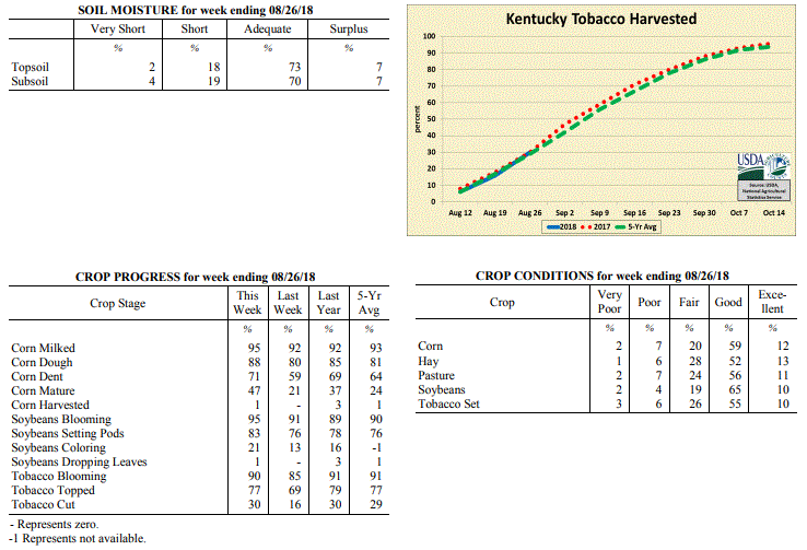 Kentucky Climate Summary
For the Period August 20 to August 26, 2018
Below Normal Temperatures and Rainfall:
Rainfall was scattered in coverage for most of the week, leading to quite different
totals from one location to another. While some locations picked up more than an
inch of rainfall, others were under a tenth. A couple rounds of storms early in the
period ended on Tuesday with the passage of a cold front. Behind the boundary, much
cooler and drier air filtered into the Bluegrass State, bringing the area a glimpse
of fall. Highs only rose into the 70s midweek and lows dropped into the 50s. Saying
that, the fall-like air mass was short lived as heat and humidity gradually returned
over the weekend. By Sunday, high temperatures were back to around 90 with the heat
index in the middle 90s to around 100.
Temperatures for the period averaged 73 degrees across the state which was 2 degrees
cooler than normal and 2 degrees cooler than the previous period. High temperatures
averaged from 82 in the West to 82 in the East. Departure from normal high
temperatures ranged from 6 degrees cooler than normal in the West to 4 degrees
cooler than normal in the East. Low temperatures averaged from 65 degrees in the
West to 63 degrees in the East. Departure from normal low temperature ranged from
near normal in the West to 1 degree warmer than normal in the East. The extreme high
temperature for the period was 94 degrees at GREENVILLE 6N and the extreme low was
49 degrees at MCKEE 5S.
Precipitation (liq. equ.) for the period totaled 0.55 inches statewide which was 0.27
inches below normal and 67% of normal. Precipitation totals by climate division, West
0.54 inches, Central 0.59 inches, Bluegrass 0.70 inches and East 0.37 inches, which
was 0.2, 0.24, 0.12 and 0.51 inches below normal. By station, precipitation totals
ranged from a low of 0.00 inches at MCKEE 5S to a high of 1.55 inches at CAMPBELLSVILLE 7W.
---
Kentucky Crop and Weather Report
Issued 4:00 P.M., August 20, 2018 25-18
Agricultural News: Kentucky experienced near normal temperatures and above normal
rainfall over the past week. Precipitation for the week totaled 1.70 inches, 0.84
inches above normal. Temperatures averaged 76 degrees for the week, unchanged from
normal. Topsoil moisture was rated 1 percent very short, 18 percent short, 68 percent
adequate, and 13 percent surplus. Subsoil moisture was rated 3 percent very short, 22
percent short, 64 percent adequate, and 11 percent surplus. Days suitable for
fieldwork averaged 4.3 out of a possible seven.
Primary activities for this week included continued hay harvesting along with topping
and cutting tobacco. Corn harvest preparations have begun for some farmers. In areas
of the state fieldwork progress was hampered by scattered precipitation. Rain was
heavy at times, however widespread crop damage was not reported. Corn, soybeans, tobacco,
and pasture remain in mostly good condition at this juncture.
Kentucky Climate Summary
For the Period August 20 to August 26, 2018
Below Normal Temperatures and Rainfall:
Rainfall was scattered in coverage for most of the week, leading to quite different
totals from one location to another. While some locations picked up more than an
inch of rainfall, others were under a tenth. A couple rounds of storms early in the
period ended on Tuesday with the passage of a cold front. Behind the boundary, much
cooler and drier air filtered into the Bluegrass State, bringing the area a glimpse
of fall. Highs only rose into the 70s midweek and lows dropped into the 50s. Saying
that, the fall-like air mass was short lived as heat and humidity gradually returned
over the weekend. By Sunday, high temperatures were back to around 90 with the heat
index in the middle 90s to around 100.
Temperatures for the period averaged 73 degrees across the state which was 2 degrees
cooler than normal and 2 degrees cooler than the previous period. High temperatures
averaged from 82 in the West to 82 in the East. Departure from normal high
temperatures ranged from 6 degrees cooler than normal in the West to 4 degrees
cooler than normal in the East. Low temperatures averaged from 65 degrees in the
West to 63 degrees in the East. Departure from normal low temperature ranged from
near normal in the West to 1 degree warmer than normal in the East. The extreme high
temperature for the period was 94 degrees at GREENVILLE 6N and the extreme low was
49 degrees at MCKEE 5S.
Precipitation (liq. equ.) for the period totaled 0.55 inches statewide which was 0.27
inches below normal and 67% of normal. Precipitation totals by climate division, West
0.54 inches, Central 0.59 inches, Bluegrass 0.70 inches and East 0.37 inches, which
was 0.2, 0.24, 0.12 and 0.51 inches below normal. By station, precipitation totals
ranged from a low of 0.00 inches at MCKEE 5S to a high of 1.55 inches at CAMPBELLSVILLE 7W.
---
Kentucky Crop and Weather Report
Issued 4:00 P.M., August 20, 2018 25-18
Agricultural News: Kentucky experienced near normal temperatures and above normal
rainfall over the past week. Precipitation for the week totaled 1.70 inches, 0.84
inches above normal. Temperatures averaged 76 degrees for the week, unchanged from
normal. Topsoil moisture was rated 1 percent very short, 18 percent short, 68 percent
adequate, and 13 percent surplus. Subsoil moisture was rated 3 percent very short, 22
percent short, 64 percent adequate, and 11 percent surplus. Days suitable for
fieldwork averaged 4.3 out of a possible seven.
Primary activities for this week included continued hay harvesting along with topping
and cutting tobacco. Corn harvest preparations have begun for some farmers. In areas
of the state fieldwork progress was hampered by scattered precipitation. Rain was
heavy at times, however widespread crop damage was not reported. Corn, soybeans, tobacco,
and pasture remain in mostly good condition at this juncture.
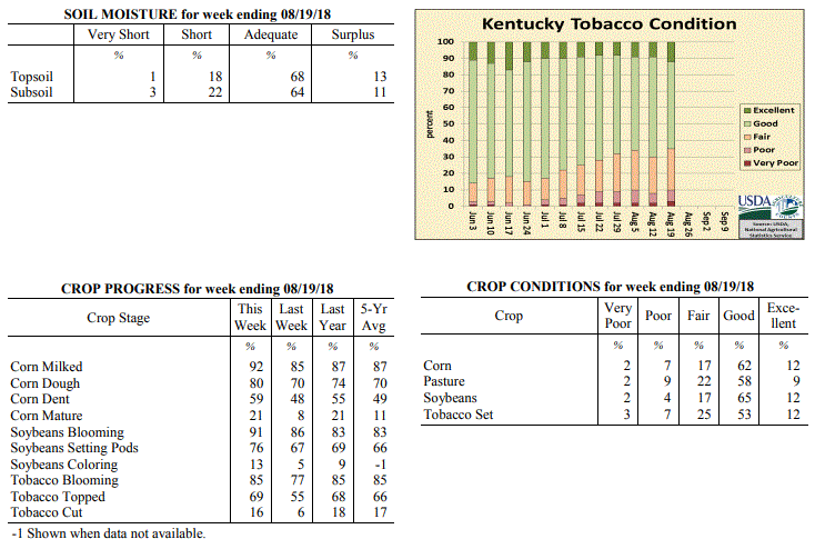 Kentucky Climate Summary
For the Period August 13 to August 19, 2018
Near Normal Temperatures and Above Normal Rainfall:
Kentucky saw above normal rainfall for a third straight week as the Lower Ohio Valley
was confined to yet another wet pattern. A combination of frontal boundaries and
upper level disturbances sparked numerous rounds throughout the period, especially
over the second half of the workweek. With a tropical air mass in place, storms
produced torrential rainfall at times leading to excessive accumulations for some
portions of Kentucky. This was the case for some North Central Kentucky counties,
which received in excess of three inches over the period. Overall, Central Kentucky
and the Bluegrass Region each averaged over two inches for the week, while Western
and Eastern Kentucky were closer to an inch.
Temperatures for the period averaged 76 degrees across the state which was near
normal and no change to the previous period. High temperatures averaged from
87 in the West to 83 in the East. Departure from normal high temperatures ranged
from 1 degree cooler than normal in the West to 3 degrees cooler than normal in
the East. Low temperatures averaged from 68 degrees in the West to 66 degrees in the
East. Departure from normal low temperature ranged from 2 degrees warmer than normal
in the West to 3 degrees warmer than normal in the East. The extreme high
temperature for the period was 94 degrees at MADISONVILLE 4S and the extreme low was
58 degrees at RICHMOND 8E.
Precipitation (liq. equ.) for the period totaled 1.70 inches statewide which was 0.84
inches above normal and 198% of normal. Precipitation totals by climate division,
West 0.87 inches, Central 2.34 inches, Bluegrass 2.50 inches and East 1.08 inches,
which was 0.09, 1.49, 1.63 and 0.15 inches above normal. By station, precipitation
totals ranged from a low of 0.13 inches at FORT CAMPBELL to a high of 5.45 inches at
CINCINNATI.
---
Kentucky Crop and Weather Report
Issued 4:00 P.M., August 13, 2018 24-18
Agricultural News: Kentucky experienced above normal temperatures and rainfall over
the past week. Precipitation for the week totaled 1.25 inches, 0.34 inches above
normal. Temperatures averaged 77 degrees for the week, 1 degrees above normal.
Topsoil moisture was rated 5 percent very short, 30 percent short, 60 percent
adequate, and 5 percent surplus. Subsoil moisture was rated 4 percent very short,
31 percent short, 59 percent adequate, and 6 percent surplus. Days suitable for
fieldwork averaged 5.3 out of a possible seven.
Primary activities for this week included hay harvesting, topping of tobacco, and
spraying. There were also reports of a small portion of the tobacco crop being cut.
In parts of the state scattered rain showers limited field activity, but improved
conditions. There were a few pockets of the state that received heavy rain, however
crop damage was not seen on a large scale. Corn, soybeans, and tobacco are in mostly
good condition at this point in the season as was pasture ground.
Kentucky Climate Summary
For the Period August 13 to August 19, 2018
Near Normal Temperatures and Above Normal Rainfall:
Kentucky saw above normal rainfall for a third straight week as the Lower Ohio Valley
was confined to yet another wet pattern. A combination of frontal boundaries and
upper level disturbances sparked numerous rounds throughout the period, especially
over the second half of the workweek. With a tropical air mass in place, storms
produced torrential rainfall at times leading to excessive accumulations for some
portions of Kentucky. This was the case for some North Central Kentucky counties,
which received in excess of three inches over the period. Overall, Central Kentucky
and the Bluegrass Region each averaged over two inches for the week, while Western
and Eastern Kentucky were closer to an inch.
Temperatures for the period averaged 76 degrees across the state which was near
normal and no change to the previous period. High temperatures averaged from
87 in the West to 83 in the East. Departure from normal high temperatures ranged
from 1 degree cooler than normal in the West to 3 degrees cooler than normal in
the East. Low temperatures averaged from 68 degrees in the West to 66 degrees in the
East. Departure from normal low temperature ranged from 2 degrees warmer than normal
in the West to 3 degrees warmer than normal in the East. The extreme high
temperature for the period was 94 degrees at MADISONVILLE 4S and the extreme low was
58 degrees at RICHMOND 8E.
Precipitation (liq. equ.) for the period totaled 1.70 inches statewide which was 0.84
inches above normal and 198% of normal. Precipitation totals by climate division,
West 0.87 inches, Central 2.34 inches, Bluegrass 2.50 inches and East 1.08 inches,
which was 0.09, 1.49, 1.63 and 0.15 inches above normal. By station, precipitation
totals ranged from a low of 0.13 inches at FORT CAMPBELL to a high of 5.45 inches at
CINCINNATI.
---
Kentucky Crop and Weather Report
Issued 4:00 P.M., August 13, 2018 24-18
Agricultural News: Kentucky experienced above normal temperatures and rainfall over
the past week. Precipitation for the week totaled 1.25 inches, 0.34 inches above
normal. Temperatures averaged 77 degrees for the week, 1 degrees above normal.
Topsoil moisture was rated 5 percent very short, 30 percent short, 60 percent
adequate, and 5 percent surplus. Subsoil moisture was rated 4 percent very short,
31 percent short, 59 percent adequate, and 6 percent surplus. Days suitable for
fieldwork averaged 5.3 out of a possible seven.
Primary activities for this week included hay harvesting, topping of tobacco, and
spraying. There were also reports of a small portion of the tobacco crop being cut.
In parts of the state scattered rain showers limited field activity, but improved
conditions. There were a few pockets of the state that received heavy rain, however
crop damage was not seen on a large scale. Corn, soybeans, and tobacco are in mostly
good condition at this point in the season as was pasture ground.
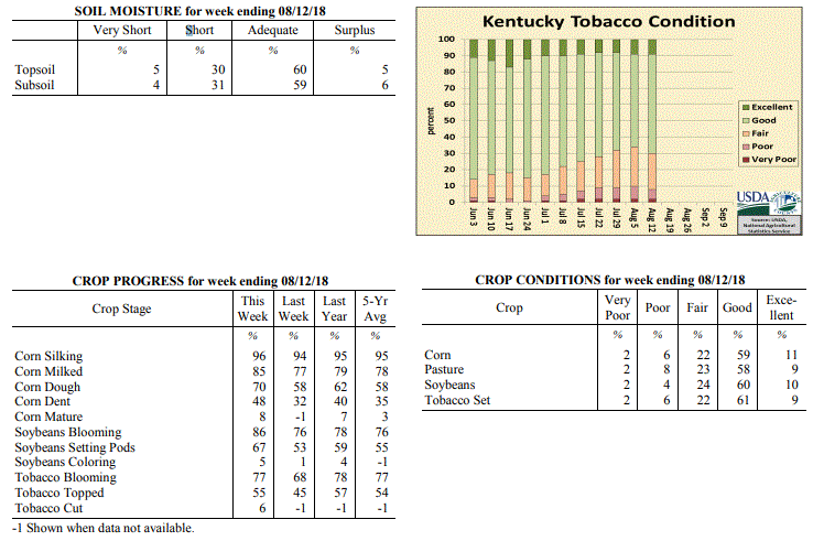 Kentucky Climate Summary
For the Period August 6 to August 12, 2018
Above Normal Temperatures and Rainfall:
The state remained situated within an active pattern for a second straight week as
Kentucky saw near daily bouts of showers and storms. While not everyone saw rainfall
each day, the repetitive nature of the storms led to significant accumulations for
much of Kentucky. The highest totals were seen across the Bluegrass, South-Central,
and Southeastern Kentucky where 2+ inches was observed for many locations, even
prompting some flooding issues. Portions of the Purchase area across Western
Kentucky also benefited with an inch+. The much-welcomed rainfall occurred as the US
Drought Monitor downgraded portions of the Purchase area into a Moderate drought with
the latest update on Thursday. Until this period, Western Kentucky had gone three
straight weeks of seeing below normal rainfall. While much of the state did see
significant rainfall, one exception was counties bordering the Ohio River from Union
County to roughly Jefferson, which received minimal amounts for the period.
Temperatures for the period averaged 77 degrees across the state which was 1 degree
warmer than normal and 2 degrees warmer than the previous period. High temperatures
averaged from 88 in the West to 84 in the East. Departure from normal high
temperatures ranged from near normal in the West to 2 degrees cooler than
normal in the East. Low temperatures averaged from 69 degrees in the West to 68
degrees in the East. Departure from normal low temperature ranged from 3 degrees
warmer than normal in the West to 5 degrees warmer than normal in the East. The
extreme high temperature for the period was 97 degrees at MADISONVILLE 4S and the
extreme low was 61 degrees at MCKEE 5S.
Precipitation (liq. equ.) for the period totaled 1.25 inches statewide which was 0.34
inches above normal and 138% of normal. Precipitation totals by climate division,
West 1.08 inches, Central 1.07 inches, Bluegrass 1.43 inches and East 1.42 inches,
which was 0.22, 0.19, 0.55 and 0.42 inches above normal. By station, precipitation
totals ranged from a low of 0.03 inches at EVANSVILLE ASOS to a high of 4.14
inches at PIKEVILLE 13S.
---
Kentucky Crop and Weather Report
Issued 4:00 P.M., August 6, 2018 23-18
Agricultural News: Kentucky experienced near normal temperatures and above normal
rainfall over the past week. Precipitation for the week totaled 1.21 inches, 0.24
inches above normal. Temperatures averaged 76 degrees for the week, unchanged from
normal. Topsoil moisture was rated 6 percent very short, 34 percent short, 55 percent
adequate and 5 percent surplus. Subsoil moisture was rated 5 percent very short, 32
percent short, 59 percent adequate, and 4 percent surplus. Days suitable for
fieldwork averaged 5.6 out of a possible seven.
Primary activities this week included scouting crops for disease, topping tobacco,
and harvesting hay. Conditions were mixed across the state, with western counties
remaining mostly dry and scattered precipitation falling in mainly central and
eastern counties. Limited rainfall had some tobacco farmers in the west irrigating
their crops, while excessive rainfall in the east had some tobacco crops turning
yellow. Continued rainfall increased forage growth as well as weed pressures in the
eastern portion of the state.
Kentucky Climate Summary
For the Period August 6 to August 12, 2018
Above Normal Temperatures and Rainfall:
The state remained situated within an active pattern for a second straight week as
Kentucky saw near daily bouts of showers and storms. While not everyone saw rainfall
each day, the repetitive nature of the storms led to significant accumulations for
much of Kentucky. The highest totals were seen across the Bluegrass, South-Central,
and Southeastern Kentucky where 2+ inches was observed for many locations, even
prompting some flooding issues. Portions of the Purchase area across Western
Kentucky also benefited with an inch+. The much-welcomed rainfall occurred as the US
Drought Monitor downgraded portions of the Purchase area into a Moderate drought with
the latest update on Thursday. Until this period, Western Kentucky had gone three
straight weeks of seeing below normal rainfall. While much of the state did see
significant rainfall, one exception was counties bordering the Ohio River from Union
County to roughly Jefferson, which received minimal amounts for the period.
Temperatures for the period averaged 77 degrees across the state which was 1 degree
warmer than normal and 2 degrees warmer than the previous period. High temperatures
averaged from 88 in the West to 84 in the East. Departure from normal high
temperatures ranged from near normal in the West to 2 degrees cooler than
normal in the East. Low temperatures averaged from 69 degrees in the West to 68
degrees in the East. Departure from normal low temperature ranged from 3 degrees
warmer than normal in the West to 5 degrees warmer than normal in the East. The
extreme high temperature for the period was 97 degrees at MADISONVILLE 4S and the
extreme low was 61 degrees at MCKEE 5S.
Precipitation (liq. equ.) for the period totaled 1.25 inches statewide which was 0.34
inches above normal and 138% of normal. Precipitation totals by climate division,
West 1.08 inches, Central 1.07 inches, Bluegrass 1.43 inches and East 1.42 inches,
which was 0.22, 0.19, 0.55 and 0.42 inches above normal. By station, precipitation
totals ranged from a low of 0.03 inches at EVANSVILLE ASOS to a high of 4.14
inches at PIKEVILLE 13S.
---
Kentucky Crop and Weather Report
Issued 4:00 P.M., August 6, 2018 23-18
Agricultural News: Kentucky experienced near normal temperatures and above normal
rainfall over the past week. Precipitation for the week totaled 1.21 inches, 0.24
inches above normal. Temperatures averaged 76 degrees for the week, unchanged from
normal. Topsoil moisture was rated 6 percent very short, 34 percent short, 55 percent
adequate and 5 percent surplus. Subsoil moisture was rated 5 percent very short, 32
percent short, 59 percent adequate, and 4 percent surplus. Days suitable for
fieldwork averaged 5.6 out of a possible seven.
Primary activities this week included scouting crops for disease, topping tobacco,
and harvesting hay. Conditions were mixed across the state, with western counties
remaining mostly dry and scattered precipitation falling in mainly central and
eastern counties. Limited rainfall had some tobacco farmers in the west irrigating
their crops, while excessive rainfall in the east had some tobacco crops turning
yellow. Continued rainfall increased forage growth as well as weed pressures in the
eastern portion of the state.
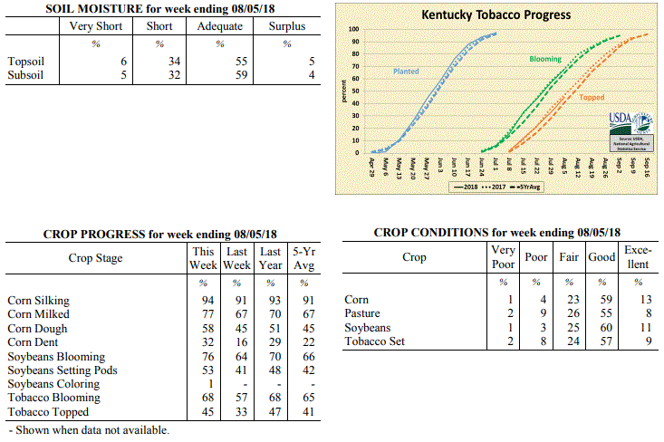 Kentucky Climate Summary
For the Period July 30 to August 5, 2018
Near Normal Temperatures and Above Normal Rainfall:
An active pattern set up for much of the Bluegrass State over the first half of the
week with multiple rounds of rainfall. The Bluegrass area of Northern Kentucky saw
the brunt of the rainfall, averaging two inches for the week. While Central and
Eastern Kentucky still averaged around an inch, Western Kentucky continued to see
lower amounts compared to the rest of Kentucky. This was especially true for the
Purchase area, where the US Drought Monitor expanded the area of ‘Abnormally dry’
conditions a bit farther east and north. Rain showers and cloud cover kept
temperatures below seasonable norms through the first half of the week, but by the
weekend, temperatures were once again back around 90 with summer-like humidity.
Temperatures for the period averaged 76 degrees across the state which was near
normal and 2 degrees warmer than the previous period. High temperatures averaged
from 86 in the West to 84 in the East. Departure from normal high temperatures ranged
from 3 degrees cooler than normal in the West to 3 degrees cooler than normal in
the East. Low temperatures averaged from 66 degrees in the West to 66 degrees in the
East. Departure from normal low temperature ranged from 1 degree cooler than normal
in the West to 2 degrees warmer than normal in the East. The extreme high temperature
for the period was 97 degrees at MADISONVILLE 4S and the extreme low was 56 degrees
at MAYFIELD 6SW.
Precipitation (liq. equ.) for the period totaled 1.21 inches statewide which was 0.24
inches above normal and 125% of normal. Precipitation totals by climate division,
West 0.79 inches, Central 1.07 inches, Bluegrass 2.01 inches and East 0.95 inches,
which was -0.14, 0.13, 1.06 and -0.09 inches respectively from normal. By station,
precipitation totals ranged from a low of 0.01 inches at BOWLING GREEN APT to a high
of 4.02 inches at OWINGSVILLE 4S.
---
Kentucky Crop and Weather Report
Issued 4:00 P.M., July 30, 2018 22-18
Agricultural News: Kentucky experienced below normal temperatures and rainfall over
the past week. Precipitation for the week totaled 0.18 inches, 0.79 inches below
normal. Temperatures averaged 73 degrees for the week, 4 degrees below normal.
Topsoil moisture was rated 6 percent very short, 30 percent short, 61 percent
adequate and 3 percent surplus. Subsoil moisture was rated 3 percent very short, 22
percent short, 71 percent adequate, and 4 percent surplus. Days suitable for
fieldwork averaged 6.0 out of a possible seven.
Primary activities this week included harvesting hay, spraying soybeans, and topping
tobacco. Dry conditions continued for western Kentucky, as central and western
portions of the state saw little rainfall this week. Overall, crop conditions have
started to decline as many areas are in need of precipitation. When scouting fields
some farmers have noticed corn pollination problems from the heat and humidity
earlier in the summer.
Throughout the season, the high frequency of rain events delayed producers from
harvesting hay on time. Most expect second and third cuttings to be of higher
quality. In eastern counties, where more ample rainfall has fallen recently, weed
pressures have increased in hayfields and pastures. Hay and roughage supplies were
reported as 4 percent very short, 19 percent short, 71 percent adequate, and 6
percent surplus.
Kentucky Climate Summary
For the Period July 30 to August 5, 2018
Near Normal Temperatures and Above Normal Rainfall:
An active pattern set up for much of the Bluegrass State over the first half of the
week with multiple rounds of rainfall. The Bluegrass area of Northern Kentucky saw
the brunt of the rainfall, averaging two inches for the week. While Central and
Eastern Kentucky still averaged around an inch, Western Kentucky continued to see
lower amounts compared to the rest of Kentucky. This was especially true for the
Purchase area, where the US Drought Monitor expanded the area of ‘Abnormally dry’
conditions a bit farther east and north. Rain showers and cloud cover kept
temperatures below seasonable norms through the first half of the week, but by the
weekend, temperatures were once again back around 90 with summer-like humidity.
Temperatures for the period averaged 76 degrees across the state which was near
normal and 2 degrees warmer than the previous period. High temperatures averaged
from 86 in the West to 84 in the East. Departure from normal high temperatures ranged
from 3 degrees cooler than normal in the West to 3 degrees cooler than normal in
the East. Low temperatures averaged from 66 degrees in the West to 66 degrees in the
East. Departure from normal low temperature ranged from 1 degree cooler than normal
in the West to 2 degrees warmer than normal in the East. The extreme high temperature
for the period was 97 degrees at MADISONVILLE 4S and the extreme low was 56 degrees
at MAYFIELD 6SW.
Precipitation (liq. equ.) for the period totaled 1.21 inches statewide which was 0.24
inches above normal and 125% of normal. Precipitation totals by climate division,
West 0.79 inches, Central 1.07 inches, Bluegrass 2.01 inches and East 0.95 inches,
which was -0.14, 0.13, 1.06 and -0.09 inches respectively from normal. By station,
precipitation totals ranged from a low of 0.01 inches at BOWLING GREEN APT to a high
of 4.02 inches at OWINGSVILLE 4S.
---
Kentucky Crop and Weather Report
Issued 4:00 P.M., July 30, 2018 22-18
Agricultural News: Kentucky experienced below normal temperatures and rainfall over
the past week. Precipitation for the week totaled 0.18 inches, 0.79 inches below
normal. Temperatures averaged 73 degrees for the week, 4 degrees below normal.
Topsoil moisture was rated 6 percent very short, 30 percent short, 61 percent
adequate and 3 percent surplus. Subsoil moisture was rated 3 percent very short, 22
percent short, 71 percent adequate, and 4 percent surplus. Days suitable for
fieldwork averaged 6.0 out of a possible seven.
Primary activities this week included harvesting hay, spraying soybeans, and topping
tobacco. Dry conditions continued for western Kentucky, as central and western
portions of the state saw little rainfall this week. Overall, crop conditions have
started to decline as many areas are in need of precipitation. When scouting fields
some farmers have noticed corn pollination problems from the heat and humidity
earlier in the summer.
Throughout the season, the high frequency of rain events delayed producers from
harvesting hay on time. Most expect second and third cuttings to be of higher
quality. In eastern counties, where more ample rainfall has fallen recently, weed
pressures have increased in hayfields and pastures. Hay and roughage supplies were
reported as 4 percent very short, 19 percent short, 71 percent adequate, and 6
percent surplus.
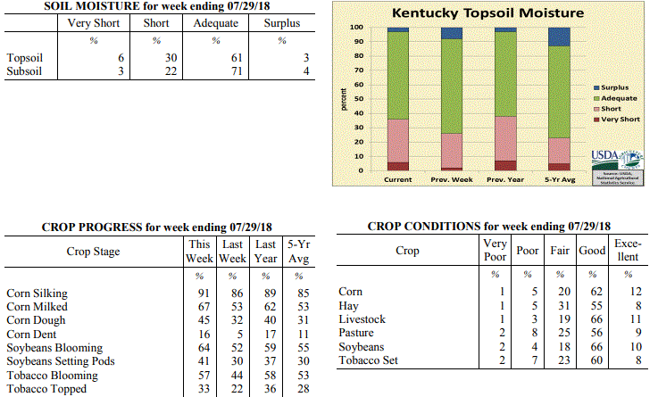 Kentucky Climate Summary
For the Period July 23 to July 29, 2018
Below Normal Temperatures and Rainfall:
Rainfall was minimal for most of the state over the course of the period. Other than
a few rounds of isolated to scattered showers/storms through the workweek, high
pressure kept the area dry. The state only averaged 0.18 inches and that number
diminished to less than a tenth of an inch across Western and Central Kentucky.
Western Kentucky missed out on much of the precipitation the week beforehand and has
now gone two straight weeks with well below normal rainfall. This has pushed portions
of far Western Kentucky into the ‘Abnormally Dry’ category by the US Drought Monitor.
While it was dry, Kentucky continued to benefit from a break in temperatures and
humidity. An upper level disturbance provided plenty of cloud cover early in the week
to keep temperatures in the middle 70s to middle 80s. While increasing midweek, a
cold front again brought temperatures and humidity back to seasonably cool and
comfortable conditions for the weekend.
Temperatures for the period averaged 73 degrees across the state which was 4 degrees
cooler than normal and 4 degrees cooler than the previous period. High temperatures
averaged from 86 in the West to 83 in the East. Departure from normal high
temperatures ranged from 3 degrees cooler than normal in the West to 4 degrees
cooler than normal in the East. Low temperatures averaged from 64 degrees in the
West to 63 degrees in the East. Departure from normal low temperature ranged from 3
degrees cooler than normal in the West to 1 degree cooler than normal in the East.
The extreme high temperature for the period was 95 degrees at POPLAR BLUFF ASOS and
the extreme low was 54 degrees at MOREHEAD 4NE.
Precipitation (liq. equ.) for the period totaled 0.18 inches statewide which was 0.79
inches below normal and 19% of normal. Precipitation totals by climate division, West
0.06 inches, Central 0.02 inches, Bluegrass 0.23 inches and East 0.41 inches, which
was 0.87, 0.96, 0.74 and 0.6 inches below normal. By station, precipitation totals
ranged from a low of 0.00 inches at BOWLING GREEN APT to a high of 2.32 inches at
RICHMOND 8E.
---
Kentucky Crop and Weather Report
Issued 4:00 P.M., July 23, 2018 21-18
Agricultural News: Kentucky experienced below normal temperatures and above normal
rainfall over the past week. Precipitation for the week totaled 1.85 inches, 0.88
inches above normal. Temperatures averaged 76 degrees for the week, 1 degree below
normal. Topsoil moisture was rated 2 percent very short, 24 percent short, 66 percent
adequate and 8 percent surplus. Subsoil moisture was rated 2 percent very short, 21
percent short, 73 percent adequate, and 4 percent surplus. Days suitable for
fieldwork averaged 5.3 out of a possible seven.
Primary activities this week included applying herbicides and fungicides, topping
tobacco, and scouting fields for damage from recent storms.
The above normal rainfall fell mostly in central and eastern portions of the state,
which did help to improve crop and pasture conditions in these areas. Western
counties still experienced below normal rainfall and continued dry conditions. The
severe storms over the weekend brought heavy rainfall, hail, and strong winds. There
were some reports of blown over tobacco, lodged corn, and damaged soybean fields.
Kentucky Climate Summary
For the Period July 23 to July 29, 2018
Below Normal Temperatures and Rainfall:
Rainfall was minimal for most of the state over the course of the period. Other than
a few rounds of isolated to scattered showers/storms through the workweek, high
pressure kept the area dry. The state only averaged 0.18 inches and that number
diminished to less than a tenth of an inch across Western and Central Kentucky.
Western Kentucky missed out on much of the precipitation the week beforehand and has
now gone two straight weeks with well below normal rainfall. This has pushed portions
of far Western Kentucky into the ‘Abnormally Dry’ category by the US Drought Monitor.
While it was dry, Kentucky continued to benefit from a break in temperatures and
humidity. An upper level disturbance provided plenty of cloud cover early in the week
to keep temperatures in the middle 70s to middle 80s. While increasing midweek, a
cold front again brought temperatures and humidity back to seasonably cool and
comfortable conditions for the weekend.
Temperatures for the period averaged 73 degrees across the state which was 4 degrees
cooler than normal and 4 degrees cooler than the previous period. High temperatures
averaged from 86 in the West to 83 in the East. Departure from normal high
temperatures ranged from 3 degrees cooler than normal in the West to 4 degrees
cooler than normal in the East. Low temperatures averaged from 64 degrees in the
West to 63 degrees in the East. Departure from normal low temperature ranged from 3
degrees cooler than normal in the West to 1 degree cooler than normal in the East.
The extreme high temperature for the period was 95 degrees at POPLAR BLUFF ASOS and
the extreme low was 54 degrees at MOREHEAD 4NE.
Precipitation (liq. equ.) for the period totaled 0.18 inches statewide which was 0.79
inches below normal and 19% of normal. Precipitation totals by climate division, West
0.06 inches, Central 0.02 inches, Bluegrass 0.23 inches and East 0.41 inches, which
was 0.87, 0.96, 0.74 and 0.6 inches below normal. By station, precipitation totals
ranged from a low of 0.00 inches at BOWLING GREEN APT to a high of 2.32 inches at
RICHMOND 8E.
---
Kentucky Crop and Weather Report
Issued 4:00 P.M., July 23, 2018 21-18
Agricultural News: Kentucky experienced below normal temperatures and above normal
rainfall over the past week. Precipitation for the week totaled 1.85 inches, 0.88
inches above normal. Temperatures averaged 76 degrees for the week, 1 degree below
normal. Topsoil moisture was rated 2 percent very short, 24 percent short, 66 percent
adequate and 8 percent surplus. Subsoil moisture was rated 2 percent very short, 21
percent short, 73 percent adequate, and 4 percent surplus. Days suitable for
fieldwork averaged 5.3 out of a possible seven.
Primary activities this week included applying herbicides and fungicides, topping
tobacco, and scouting fields for damage from recent storms.
The above normal rainfall fell mostly in central and eastern portions of the state,
which did help to improve crop and pasture conditions in these areas. Western
counties still experienced below normal rainfall and continued dry conditions. The
severe storms over the weekend brought heavy rainfall, hail, and strong winds. There
were some reports of blown over tobacco, lodged corn, and damaged soybean fields.
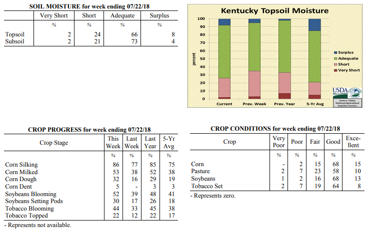 Kentucky Climate Summary
For the Period July 16 to July 22, 2018
Below Normal Temperatures and Above Normal Rainfall:
Damaging storms developed this past week, in addition to a long awaited break in
summer heat. The main focus was Friday as the state sat within a very unstable air
mass. Multiple rounds of severe storms moved through the area during the afternoon
hours and carrying into the evening/overnight, producing everything from torrential
rainfall, large hail, damaging winds, and even a few weak tornadoes. The majority of
the severe weather and rainfall was situated across the Bluegrass and Central/Eastern
Kentucky. In addition to activity early in the period and over the weekend, these
areas averaged over two inches for the week. Western Kentucky missed out on much of
the rainfall and averaged under a third of an inch. Temperature-wise, conditions
were a bit cooler for the week, especially over the weekend as showers and cloud
cover kept highs limited to the middle 70s to middle 80s. Overall, Kentucky temperatures
averaged below normal for the week, which is the first time that had happened since
the end of April.
Temperatures for the period averaged 76 degrees across the state which was 1 degree
cooler than normal and 2 degrees cooler than the previous period. High temperatures
averaged from 88 in the West to 85 in the East. Departure from normal high
temperatures ranged from 2 degrees cooler than normal in the West to 2 degrees
cooler than normal in the East. Low temperatures averaged from 69 degrees in the
West to 66 degrees in the East. Departure from normal low temperature ranged from 1
degree warmer than normal in the West to 2 degrees warmer than normal in the East.
The extreme high temperature for the period was 96 degrees at POPLAR BLUFF ASOS and
the extreme low was 55 degrees at PAINTSVILLE 4W.
Precipitation (liq. equ.) for the period totaled 1.85 inches statewide which was 0.88
inches above normal and 191% of normal. Precipitation totals by climate division,
West 0.29 inches, Central 1.93 inches, Bluegrass 2.74 inches and East 2.43 inches,
which was -0.64, 0.94, 1.80 and 1.42 inches respectively from normal. By station,
precipitation totals ranged from a low of 0.00 inches at CAMPBELLSVILLE 7W to a high
of 5.86 inches at MCKEE 5S.
---
Kentucky Crop and Weather Report
Issued 4:00 P.M., July 16, 2018 20-18
Agricultural News: Kentucky experienced above normal temperatures and below
normal rainfall over the past week. Precipitation for the week totaled 0.41
inches, 0.58 inches below normal. Temperatures averaged 78 degrees for the week,
1 degree above normal. Topsoil moisture was rated 3 percent very short, 32
percent short, 60 percent adequate and 5 percent surplus. Subsoil moisture was
rated 2 percent very short, 24 percent short, 70 percent adequate, and 4 percent
surplus. Days suitable for fieldwork averaged 6.4 out of a possible seven.
Primary activities this week included spraying soybeans, applying fungicides to
corn, baling hay, and scouting fields. The high temperatures and limited
rainfall have continued to show effects of stress on crops and pastures.
Scattered showers during the week varied the impacts of moisture stress
throughout the state. The dry weather did allow farmers to catch up on
fieldwork. Depleted pastures had some cattle producers feeding hay and
supplementing.
Farmers continue to monitor tobacco fields for disease; some incidences of black
shank have been reported.
Kentucky Climate Summary
For the Period July 16 to July 22, 2018
Below Normal Temperatures and Above Normal Rainfall:
Damaging storms developed this past week, in addition to a long awaited break in
summer heat. The main focus was Friday as the state sat within a very unstable air
mass. Multiple rounds of severe storms moved through the area during the afternoon
hours and carrying into the evening/overnight, producing everything from torrential
rainfall, large hail, damaging winds, and even a few weak tornadoes. The majority of
the severe weather and rainfall was situated across the Bluegrass and Central/Eastern
Kentucky. In addition to activity early in the period and over the weekend, these
areas averaged over two inches for the week. Western Kentucky missed out on much of
the rainfall and averaged under a third of an inch. Temperature-wise, conditions
were a bit cooler for the week, especially over the weekend as showers and cloud
cover kept highs limited to the middle 70s to middle 80s. Overall, Kentucky temperatures
averaged below normal for the week, which is the first time that had happened since
the end of April.
Temperatures for the period averaged 76 degrees across the state which was 1 degree
cooler than normal and 2 degrees cooler than the previous period. High temperatures
averaged from 88 in the West to 85 in the East. Departure from normal high
temperatures ranged from 2 degrees cooler than normal in the West to 2 degrees
cooler than normal in the East. Low temperatures averaged from 69 degrees in the
West to 66 degrees in the East. Departure from normal low temperature ranged from 1
degree warmer than normal in the West to 2 degrees warmer than normal in the East.
The extreme high temperature for the period was 96 degrees at POPLAR BLUFF ASOS and
the extreme low was 55 degrees at PAINTSVILLE 4W.
Precipitation (liq. equ.) for the period totaled 1.85 inches statewide which was 0.88
inches above normal and 191% of normal. Precipitation totals by climate division,
West 0.29 inches, Central 1.93 inches, Bluegrass 2.74 inches and East 2.43 inches,
which was -0.64, 0.94, 1.80 and 1.42 inches respectively from normal. By station,
precipitation totals ranged from a low of 0.00 inches at CAMPBELLSVILLE 7W to a high
of 5.86 inches at MCKEE 5S.
---
Kentucky Crop and Weather Report
Issued 4:00 P.M., July 16, 2018 20-18
Agricultural News: Kentucky experienced above normal temperatures and below
normal rainfall over the past week. Precipitation for the week totaled 0.41
inches, 0.58 inches below normal. Temperatures averaged 78 degrees for the week,
1 degree above normal. Topsoil moisture was rated 3 percent very short, 32
percent short, 60 percent adequate and 5 percent surplus. Subsoil moisture was
rated 2 percent very short, 24 percent short, 70 percent adequate, and 4 percent
surplus. Days suitable for fieldwork averaged 6.4 out of a possible seven.
Primary activities this week included spraying soybeans, applying fungicides to
corn, baling hay, and scouting fields. The high temperatures and limited
rainfall have continued to show effects of stress on crops and pastures.
Scattered showers during the week varied the impacts of moisture stress
throughout the state. The dry weather did allow farmers to catch up on
fieldwork. Depleted pastures had some cattle producers feeding hay and
supplementing.
Farmers continue to monitor tobacco fields for disease; some incidences of black
shank have been reported.
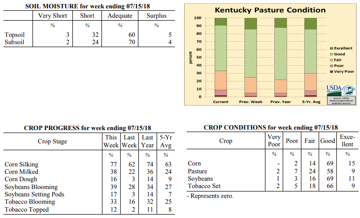 Kentucky Climate Summary
For the Period July 09 to July 15, 2018
Above Normal Temperatures and Below Normal Rainfall:
The second week straight in July with dry conditions was unlike the very wet
first-half of the year for the Bluegrass State. Several counties in the west did
a little bit better on the rain than the remainder of the state pushing the
western climate division above normal for rainfall. The west also had more of
the heat than the remainder of the state but a couple of slightly cooler days
occurred at mid-week. Yet, the trend of warmer than normal temperatures
continued for the week and for the past 11 weeks.
Temperatures for the period averaged 78 degrees across the state which was 1
degree warmer than normal and 2 degrees cooler than the previous period. High
temperatures averaged from 90 in the West to 88 in the East. Departure from
normal high temperatures ranged from near in the West to 1 degree warmer than
normal in the East. Low temperatures averaged from 70 degrees in the West to 66
degrees in the East. Departure from normal low temperature ranged from 2 degrees
warmer than normal in the West to 3 degrees warmer than normal in the East. The
extreme high temperature for the period was 98 degrees at PADUCAH ASOS and the
extreme low was 57 degrees at MONTICELLO AWOS.
Kentucky Climate Summary
For the Period July 09 to July 15, 2018
Above Normal Temperatures and Below Normal Rainfall:
The second week straight in July with dry conditions was unlike the very wet
first-half of the year for the Bluegrass State. Several counties in the west did
a little bit better on the rain than the remainder of the state pushing the
western climate division above normal for rainfall. The west also had more of
the heat than the remainder of the state but a couple of slightly cooler days
occurred at mid-week. Yet, the trend of warmer than normal temperatures
continued for the week and for the past 11 weeks.
Temperatures for the period averaged 78 degrees across the state which was 1
degree warmer than normal and 2 degrees cooler than the previous period. High
temperatures averaged from 90 in the West to 88 in the East. Departure from
normal high temperatures ranged from near in the West to 1 degree warmer than
normal in the East. Low temperatures averaged from 70 degrees in the West to 66
degrees in the East. Departure from normal low temperature ranged from 2 degrees
warmer than normal in the West to 3 degrees warmer than normal in the East. The
extreme high temperature for the period was 98 degrees at PADUCAH ASOS and the
extreme low was 57 degrees at MONTICELLO AWOS.
Precipitation (liq. equ.) for the period totaled 0.41 inches statewide which was
0.58 inches below normal and 41% of normal. Precipitation totals by climate
division, West 1.10 inches, Central 0.28 inches, Bluegrass 0.08 inches and East
0.16 inches, which was 0.12, -0.72, -0.90 and -0.85 inches respectively from
normal. By station, precipitation totals ranged from a low of 0.00 inches at
ALEXANDRIA 5NW to a high of 2.52 inches at CADIZ 4SW.
Summarized and averaged data for the period 20180709 to 20180715(Last 7 Days)
(Not for Legal purposes. Departure from Norms based on climate divisional Averages)
AIR TEMPERATURE PRECIPITATION ExtremeTemp
STATION MAX DEV MIN DEV AVR DEV TOTAL DEV %NORM HI LO
--------------------------------------------------------------------------------
WEST(CD1) 90 0 70 2 80 1 1.10 0.12 112 98 62
CENTRAL(CD2) 88 0 68 2 78 1 0.28 -0.72 28 95 58
BLUEGRASS(CD3) 88 1 67 2 77 1 0.08 -0.90 8 94 58
EAST(CD4) 88 1 66 3 77 2 0.16 -0.85 16 93 57
--------------------------------------------------------------------------------
STATE 88 0 68 2 78 1 0.41 -0.58 41 98 57
---
Kentucky Crop and Weather Report
Issued 4:00 P.M., July 9, 2018 19-18
Agricultural News: Kentucky experienced above normal temperatures and below normal
rainfall over the past week. Precipitation for the week totaled 0.62 inches, 0.37
inches below normal. Temperatures averaged 79 degrees for the week, 3 degrees above
normal. Topsoil moisture was rated 1 percent very short, 11 percent short, 78 percent
adequate, and 10 percent surplus. Subsoil moisture was rated 1 percent very short, 9
percent short, 81 percent adequate, and 9 percent surplus. Days suitable for
fieldwork averaged 5.5 out of a possible seven.
Primary activities for this week included cutting hay and spraying crops. Corn,
soybeans, and tobacco are in mostly good condition at this time despite several
reports of damage from heavy rain and disease. The average height of emerged soybeans
was 20 inches.
Pasture land is in mostly good condition and has started improving in some areas due
to rain this past week. Farmers continue to cut hay and the hay crop should be aided
by the precipitation in some areas.
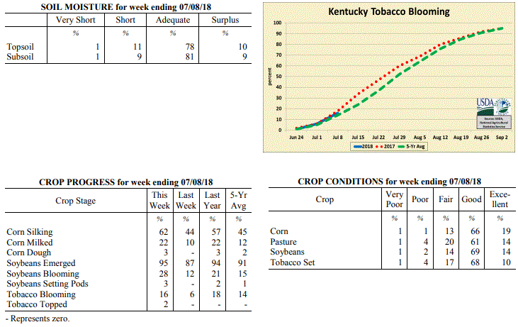 Kentucky Climate Summary
For the Period July 2 to July 8, 2018
Above Normal Temperatures and Below Normal Rainfall:
Oppressive heat continued across the Lower Ohio Valley for the first week of July.
Temperatures peaked on the 4th and the 5th with highs getting into the low to middle
90s. Even some upper 90s in spots. ‘Heat Advisories’ and even some ‘Excessive Heat
Warnings’ were issued as heat indices topped out around 110 degrees at times.
Luckily, the Commonwealth did see a cold front push through the area on Friday.
While temperatures stayed in the 80s for Saturday, conditions were noticeably less
humid. Even with the frontal passage, the heat won out and led to a 10th straight
week of above normal temperatures, dating back to the start of May. Looking at
rainfall, coverage was scattered to numerous at times, but not nearly as frequent as
weeks past. Still, torrential downpours continued to be an issue for anyone that did
see a storm. Overall, the state averaged 0.62 inches for the week, but totals varied
widely across Kentucky with the scattered coverage in place. While some saw in excess
of 1.5 inches, other locations were less than a tenth of an inch.
Temperatures for the period averaged 79 degrees across the state which was 3 degrees
warmer than normal and 2 degrees warmer than the previous period. High temperatures
averaged from 90 in the West to 89 in the East. Departure from normal high
temperatures ranged from 1 degree warmer than normal in the West to 3 degrees
warmer than normal in the East. Low temperatures averaged from 72 degrees in the
West to 68 degrees in the East. Departure from normal low temperature ranged from 5
degrees warmer than normal in the West to 6 degrees warmer than normal in the East.
The extreme high temperature for the period was 98 degrees at CAPE GIRARDEAU ASOS and
the extreme low was 56 degrees at CYNTHIANA 8N.
Precipitation (liq. equ.) for the period totaled 0.62 inches statewide which was 0.37
inches below normal and 63% of normal. Precipitation totals by climate division, West
0.41 inches, Central 0.75 inches, Bluegrass 0.59 inches and East 0.73 inches, which
was 0.59, 0.24, 0.37 and 0.28 inches below normal. By station, precipitation totals
ranged from a low of 0.00 inches at BIG SANDY to a high of 2.84 inches at BOWLING GREEN 4E.
---
Kentucky Crop and Weather Report
Issued 4:00 P.M., July 2, 2018 18-18
Agricultural News: Kentucky experienced above normal temperatures and much above
normal rainfall over the past week. Precipitation for the week totaled 2.70 inches,
1.72 inches above normal. Temperatures averaged 78 degrees for the week, 3 degrees
above normal. Topsoil moisture was rated 4 percent short, 74 percent adequate and 22
percent surplus. Subsoil moisture was rated 5 percent short, 78 percent adequate, and
17 percent surplus. Days suitable for fieldwork averaged 3.3 out of a possible seven.
Primary activities this week included harvesting wheat and hay, planting soybeans,
spraying fungicides, and scouting fields for damage from recent weather. Heavy
rainfall, high winds, heat, and humidity over the past week had varied impacts across
the state. Damage reports included crop stress, tobacco laid over from winds, and
excessive moisture in pastures and crop fields. Fieldwork was delayed at times as
farmers tried to finish up winter wheat harvest and soybean planting. The average
height of emerged soybeans was 13 inches, compared with 10 inches last year.
Several reports of hay yields being low and of marginal quality due to over-maturity
from harvesting delays. The quality of harvested hay was rated 64% in good to
excellent condition. Producers are more optimistic for second cutting yields from
recent rains.
Kentucky Climate Summary
For the Period July 2 to July 8, 2018
Above Normal Temperatures and Below Normal Rainfall:
Oppressive heat continued across the Lower Ohio Valley for the first week of July.
Temperatures peaked on the 4th and the 5th with highs getting into the low to middle
90s. Even some upper 90s in spots. ‘Heat Advisories’ and even some ‘Excessive Heat
Warnings’ were issued as heat indices topped out around 110 degrees at times.
Luckily, the Commonwealth did see a cold front push through the area on Friday.
While temperatures stayed in the 80s for Saturday, conditions were noticeably less
humid. Even with the frontal passage, the heat won out and led to a 10th straight
week of above normal temperatures, dating back to the start of May. Looking at
rainfall, coverage was scattered to numerous at times, but not nearly as frequent as
weeks past. Still, torrential downpours continued to be an issue for anyone that did
see a storm. Overall, the state averaged 0.62 inches for the week, but totals varied
widely across Kentucky with the scattered coverage in place. While some saw in excess
of 1.5 inches, other locations were less than a tenth of an inch.
Temperatures for the period averaged 79 degrees across the state which was 3 degrees
warmer than normal and 2 degrees warmer than the previous period. High temperatures
averaged from 90 in the West to 89 in the East. Departure from normal high
temperatures ranged from 1 degree warmer than normal in the West to 3 degrees
warmer than normal in the East. Low temperatures averaged from 72 degrees in the
West to 68 degrees in the East. Departure from normal low temperature ranged from 5
degrees warmer than normal in the West to 6 degrees warmer than normal in the East.
The extreme high temperature for the period was 98 degrees at CAPE GIRARDEAU ASOS and
the extreme low was 56 degrees at CYNTHIANA 8N.
Precipitation (liq. equ.) for the period totaled 0.62 inches statewide which was 0.37
inches below normal and 63% of normal. Precipitation totals by climate division, West
0.41 inches, Central 0.75 inches, Bluegrass 0.59 inches and East 0.73 inches, which
was 0.59, 0.24, 0.37 and 0.28 inches below normal. By station, precipitation totals
ranged from a low of 0.00 inches at BIG SANDY to a high of 2.84 inches at BOWLING GREEN 4E.
---
Kentucky Crop and Weather Report
Issued 4:00 P.M., July 2, 2018 18-18
Agricultural News: Kentucky experienced above normal temperatures and much above
normal rainfall over the past week. Precipitation for the week totaled 2.70 inches,
1.72 inches above normal. Temperatures averaged 78 degrees for the week, 3 degrees
above normal. Topsoil moisture was rated 4 percent short, 74 percent adequate and 22
percent surplus. Subsoil moisture was rated 5 percent short, 78 percent adequate, and
17 percent surplus. Days suitable for fieldwork averaged 3.3 out of a possible seven.
Primary activities this week included harvesting wheat and hay, planting soybeans,
spraying fungicides, and scouting fields for damage from recent weather. Heavy
rainfall, high winds, heat, and humidity over the past week had varied impacts across
the state. Damage reports included crop stress, tobacco laid over from winds, and
excessive moisture in pastures and crop fields. Fieldwork was delayed at times as
farmers tried to finish up winter wheat harvest and soybean planting. The average
height of emerged soybeans was 13 inches, compared with 10 inches last year.
Several reports of hay yields being low and of marginal quality due to over-maturity
from harvesting delays. The quality of harvested hay was rated 64% in good to
excellent condition. Producers are more optimistic for second cutting yields from
recent rains.
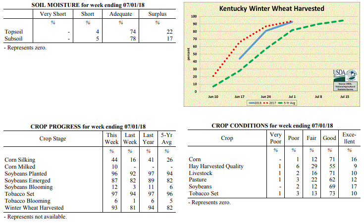 Kentucky Climate Summary
For the Period June 25 to July 1, 2018
Above Normal Temperatures and Much Above Normal Rainfall:
Excessively wet conditions were the highlight of the period. Kentucky saw several
rounds of storms push through the region over the course of the week. The more
intense period lasted from Monday through Thursday with clusters and lines of storms
producing torrential rainfall, damaging winds and even a few confirmed tornadoes.
Tropical-like downpours and repeated rounds of rainfall led to many bouts of
localized flash flooding. Overall, the state averaged 2.70 inches for the week,
which is the most Kentucky had seen in one week since February. While there was
additional isolated to scattered activity over the weekend, the bigger story was the
heat. Temperatures peaked in the low to middle 90s each day. Combined with dew
points in the 70s, heat indices topped well over the century mark. This prompted a
heat advisory to be issued for much of the western half of Kentucky and led to a
ninth straight week of above normal temperatures for the Bluegrass State. The
elevated heat continued to pose a concern for livestock as the heat stress index ran
in the danger to emergency categories.
Temperatures for the period averaged 78 degrees across the state which was 3 degrees
warmer than normal and no change to the previous period. High temperatures averaged
from 89 in the West to 85 in the East. Departure from normal high temperatures ranged
from 1 degree warmer than normal in the West to near normal in the East. Low
temperatures averaged from 71 degrees in the West to 68 degrees in the East.
Departure from normal low temperature ranged from 5 degrees warmer than normal in the
West to 7 degrees warmer than normal in the East. The extreme high temperature for
the period was 96 degrees at MAYSVILLE 3SW and the extreme low was 61 degrees at
PIKEVILLE 13S.
Precipitation (liq. equ.) for the period totaled 2.70 inches statewide which was 1.72
inches above normal and 274% of normal. Precipitation totals by climate division,
West 2.97 inches, Central 3.36 inches, Bluegrass 2.09 inches and East 2.37 inches,
which was 1.99, 2.39, 1.12 and 1.35 inches above normal. By station, precipitation
totals ranged from a low of 0.54 inches at TRIANGLE MOUNTAIN to a high of 6.15
inches at CAPE GIRARDEAU ASOS.
---
Kentucky Crop and Weather Report
Issued 4:00 P.M., June 25, 2018 17-18
Agricultural News: Kentucky experienced above normal temperatures and rainfall over
the past week. Precipitation for the week totaled 1.25 inches, 0.23 inches above
normal. Temperatures averaged 78 degrees for the week, 4 degrees above normal.
Topsoil moisture was rated 1 percent very short, 11 percent short, 77 percent
adequate, and 11 percent surplus. Subsoil moisture was rated 1 percent very short, 8
percent short, 84 percent adequate, and 7 percent surplus. Days suitable for
fieldwork averaged 5.0 out of a possible seven.
Primary activities for this week included harvesting wheat, cutting hay, and planting
soybeans. The weather early in the week was suitable for fieldwork, however as the
week progressed rain and cooler temperatures arrived. The average height of emerged
soybeans was 5 inches. Corn, soybeans, and wheat are all in mostly good condition at
this time.
Ninety four percent of the tobacco crop is in the ground, slightly ahead of both last
year and the five year average. The crop is in mostly good condition with the average
height of plants at 16 inches. Both pastures and hay are in mostly good condition at
this juncture.
Kentucky Climate Summary
For the Period June 25 to July 1, 2018
Above Normal Temperatures and Much Above Normal Rainfall:
Excessively wet conditions were the highlight of the period. Kentucky saw several
rounds of storms push through the region over the course of the week. The more
intense period lasted from Monday through Thursday with clusters and lines of storms
producing torrential rainfall, damaging winds and even a few confirmed tornadoes.
Tropical-like downpours and repeated rounds of rainfall led to many bouts of
localized flash flooding. Overall, the state averaged 2.70 inches for the week,
which is the most Kentucky had seen in one week since February. While there was
additional isolated to scattered activity over the weekend, the bigger story was the
heat. Temperatures peaked in the low to middle 90s each day. Combined with dew
points in the 70s, heat indices topped well over the century mark. This prompted a
heat advisory to be issued for much of the western half of Kentucky and led to a
ninth straight week of above normal temperatures for the Bluegrass State. The
elevated heat continued to pose a concern for livestock as the heat stress index ran
in the danger to emergency categories.
Temperatures for the period averaged 78 degrees across the state which was 3 degrees
warmer than normal and no change to the previous period. High temperatures averaged
from 89 in the West to 85 in the East. Departure from normal high temperatures ranged
from 1 degree warmer than normal in the West to near normal in the East. Low
temperatures averaged from 71 degrees in the West to 68 degrees in the East.
Departure from normal low temperature ranged from 5 degrees warmer than normal in the
West to 7 degrees warmer than normal in the East. The extreme high temperature for
the period was 96 degrees at MAYSVILLE 3SW and the extreme low was 61 degrees at
PIKEVILLE 13S.
Precipitation (liq. equ.) for the period totaled 2.70 inches statewide which was 1.72
inches above normal and 274% of normal. Precipitation totals by climate division,
West 2.97 inches, Central 3.36 inches, Bluegrass 2.09 inches and East 2.37 inches,
which was 1.99, 2.39, 1.12 and 1.35 inches above normal. By station, precipitation
totals ranged from a low of 0.54 inches at TRIANGLE MOUNTAIN to a high of 6.15
inches at CAPE GIRARDEAU ASOS.
---
Kentucky Crop and Weather Report
Issued 4:00 P.M., June 25, 2018 17-18
Agricultural News: Kentucky experienced above normal temperatures and rainfall over
the past week. Precipitation for the week totaled 1.25 inches, 0.23 inches above
normal. Temperatures averaged 78 degrees for the week, 4 degrees above normal.
Topsoil moisture was rated 1 percent very short, 11 percent short, 77 percent
adequate, and 11 percent surplus. Subsoil moisture was rated 1 percent very short, 8
percent short, 84 percent adequate, and 7 percent surplus. Days suitable for
fieldwork averaged 5.0 out of a possible seven.
Primary activities for this week included harvesting wheat, cutting hay, and planting
soybeans. The weather early in the week was suitable for fieldwork, however as the
week progressed rain and cooler temperatures arrived. The average height of emerged
soybeans was 5 inches. Corn, soybeans, and wheat are all in mostly good condition at
this time.
Ninety four percent of the tobacco crop is in the ground, slightly ahead of both last
year and the five year average. The crop is in mostly good condition with the average
height of plants at 16 inches. Both pastures and hay are in mostly good condition at
this juncture.
 Kentucky Climate Summary
For the Period June 18 to June 24, 2018
Above Normal Temperatures and Rainfall:
Heat and humidity has been unrelenting recently and that trend continued over the
course of the period, especially early in the week. Continuing from the hot and humid
weekend beforehand, temperatures on Monday and Tuesday reached into the upper 80s to
middle 90s for much of the state. Combined with dew points in the 70s, heat indices
topped out around 100 at times. This led the way in pushing Kentucky to an eighth
straight week of above normal temperatures. In addition to the warmth, an active
pattern led to several rounds of rainfall. Most of the time, storms remained isolated
to scattered in coverage, but unlike recent weeks, the state did see a round of
widespread showers on Thursday. Even with the scattered coverage, the repetitive
nature of the storms did lead to accumulations of more than an inch for most of Kentucky.
Temperatures for the period averaged 78 degrees across the state which was 4 degrees
warmer than normal and 2 degrees warmer than the previous period. High temperatures
averaged from 86 in the West to 86 in the East. Departure from normal high
temperatures ranged from 1 degree cooler than normal in the West to 2 degrees
warmer than normal in the East. Low temperatures averaged from 69 degrees in the
West to 68 degrees in the East. Departure from normal low temperature ranged from 5
degrees warmer than normal in the West to 8 degrees warmer than normal in the East.
The extreme high temperature for the period was 96 degrees at LOUISA 1S and the
extreme low was 62 degrees at BARBOURVILLE 3E.
Precipitation (liq. equ.) for the period totaled 1.25 inches statewide which was 0.23
inches above normal and 123% of normal. Precipitation totals by climate division,
West 1.18 inches, Central 1.15 inches, Bluegrass 1.33 inches and East 1.35 inches,
which was 0.17, 0.14, 0.31 and 0.32 inches above normal. By station, precipitation
totals ranged from a low of 0.16 inches at MONTICELLO AWOS to a high of 4.00 inches
at VANCEBURG 6W.
---
Kentucky Crop and Weather Report
Issued 4:00 P.M., June 18, 2018 16-18
Agricultural News: Kentucky experienced above normal temperatures and near normal
rainfall over the past week. Precipitation for the week totaled 1.03 inches, 0.01
inches above normal. Temperatures averaged 77 degrees for the week, 5 degrees above
normal. Topsoil moisture was rated 1 percent very short, 19 percent short, 75 percent
adequate and 5 percent surplus. Subsoil moisture was rated 1 percent very short, 12
percent short, 82 percent adequate, and 5 percent surplus. Days suitable for
fieldwork averaged 5.3 out of a possible seven.
Primary activities this week included harvesting wheat, cutting hay, planting
soybeans and tobacco, as well as applying fertilizers and herbicides. Scattered
showers during the week delayed fieldwork at times. Overall, the hot and dry weather
have crop fields and pastures starting to show signs of stress. The heat has made for
good hay curing weather though. The average height of emerged corn was 34 inches,
compared to 38 inches last year. The average height of tobacco in the field was 11
inches, compared to 9 inches last year.
Some producers have noted low test weights for wheat, and higher temperatures in the
spring and short grain fill as contributing factors. Additionally, farmers are
anticipating initial hay yields to be lower than the first cuttings for last year.
Kentucky Climate Summary
For the Period June 18 to June 24, 2018
Above Normal Temperatures and Rainfall:
Heat and humidity has been unrelenting recently and that trend continued over the
course of the period, especially early in the week. Continuing from the hot and humid
weekend beforehand, temperatures on Monday and Tuesday reached into the upper 80s to
middle 90s for much of the state. Combined with dew points in the 70s, heat indices
topped out around 100 at times. This led the way in pushing Kentucky to an eighth
straight week of above normal temperatures. In addition to the warmth, an active
pattern led to several rounds of rainfall. Most of the time, storms remained isolated
to scattered in coverage, but unlike recent weeks, the state did see a round of
widespread showers on Thursday. Even with the scattered coverage, the repetitive
nature of the storms did lead to accumulations of more than an inch for most of Kentucky.
Temperatures for the period averaged 78 degrees across the state which was 4 degrees
warmer than normal and 2 degrees warmer than the previous period. High temperatures
averaged from 86 in the West to 86 in the East. Departure from normal high
temperatures ranged from 1 degree cooler than normal in the West to 2 degrees
warmer than normal in the East. Low temperatures averaged from 69 degrees in the
West to 68 degrees in the East. Departure from normal low temperature ranged from 5
degrees warmer than normal in the West to 8 degrees warmer than normal in the East.
The extreme high temperature for the period was 96 degrees at LOUISA 1S and the
extreme low was 62 degrees at BARBOURVILLE 3E.
Precipitation (liq. equ.) for the period totaled 1.25 inches statewide which was 0.23
inches above normal and 123% of normal. Precipitation totals by climate division,
West 1.18 inches, Central 1.15 inches, Bluegrass 1.33 inches and East 1.35 inches,
which was 0.17, 0.14, 0.31 and 0.32 inches above normal. By station, precipitation
totals ranged from a low of 0.16 inches at MONTICELLO AWOS to a high of 4.00 inches
at VANCEBURG 6W.
---
Kentucky Crop and Weather Report
Issued 4:00 P.M., June 18, 2018 16-18
Agricultural News: Kentucky experienced above normal temperatures and near normal
rainfall over the past week. Precipitation for the week totaled 1.03 inches, 0.01
inches above normal. Temperatures averaged 77 degrees for the week, 5 degrees above
normal. Topsoil moisture was rated 1 percent very short, 19 percent short, 75 percent
adequate and 5 percent surplus. Subsoil moisture was rated 1 percent very short, 12
percent short, 82 percent adequate, and 5 percent surplus. Days suitable for
fieldwork averaged 5.3 out of a possible seven.
Primary activities this week included harvesting wheat, cutting hay, planting
soybeans and tobacco, as well as applying fertilizers and herbicides. Scattered
showers during the week delayed fieldwork at times. Overall, the hot and dry weather
have crop fields and pastures starting to show signs of stress. The heat has made for
good hay curing weather though. The average height of emerged corn was 34 inches,
compared to 38 inches last year. The average height of tobacco in the field was 11
inches, compared to 9 inches last year.
Some producers have noted low test weights for wheat, and higher temperatures in the
spring and short grain fill as contributing factors. Additionally, farmers are
anticipating initial hay yields to be lower than the first cuttings for last year.
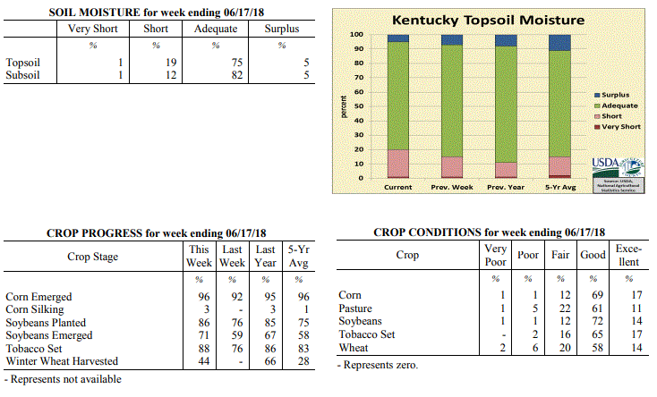 Kentucky Climate Summary
For the Period June 11 to June 17, 2018
Above Normal Temperatures and Near Normal Rainfall:
The period opened with active weather continuing from the previous weekend. Multiple
rounds of scattered to numerous storms formed on Monday and Tuesday as Kentucky sat
within an unstable air mass. Heavy rain continued to lead to localized flooding at
times, as a very moist air mass remained across the region. Strong to severe storms
even formed Monday evening with some storms producing damaging winds and small hail.
Overall, the state averaged an inch of rainfall, but just like previous weeks, the
scattered coverage of the storms led to a wide range of accumulations. After the
passage of a front late Wednesday and into the overnight, the remainder of the period
was mostly dry, but with the thermometer on the climb. Temperatures and humidity
peaked over the weekend with highs rising into the upper 80s to middle 90s and heat
indices around 100 at times. This kept the livestock heat stress index running in
the Danger category during the better part of the day.
Temperatures for the period averaged 77 degrees across the state which was 5 degrees
warmer than normal and 4 degrees warmer than the previous period. High temperatures
averaged from 90 in the West to 85 in the East. Departure from normal high
temperatures ranged from 5 degrees warmer than normal in the West to 2 degrees
warmer than normal in the East. Low temperatures averaged from 70 degrees in the
West to 65 degrees in the East. Departure from normal low temperature ranged from 7
degrees warmer than normal in the West to 7 degrees warmer than normal in the East.
The extreme high temperature for the period was 97 degrees at BOWLING GREEN APT and
the extreme low was 56 degrees at PAINTSVILLE 4W.
Precipitation (liq. equ.) for the period totaled 1.03 inches statewide which was 0.01
inches above normal and 101% of normal. Precipitation totals by climate division,
West 0.97 inches, Central 0.87 inches, Bluegrass 1.31 inches and East 0.98 inches,
which was 0.00, -0.15, 0.28 and -0.06 inches respectively from normal. By station,
precipitation totals ranged from a low of 0.00 inches at MONTICELLO AWOS to a high of
3.88 inches at STANFORD 4NE.
---
Kentucky Crop and Weather Report
Issued 4:00 P.M., June 11, 2018 15-18
Agricultural News: Kentucky experienced above normal temperatures and below normal
rainfall over the past week. Precipitation for the week totaled 0.21 inches, 0.86
inches below normal. Temperatures averaged 73 degrees for the week, 2 degrees above
normal. Topsoil moisture was rated 1 percent very short, 14 percent short, 78 percent
adequate, and 7 percent surplus. Subsoil moisture was rated 1 percent very short, 7
percent short, 85 percent adequate, and 7 percent surplus. Days suitable for
fieldwork averaged 6.0 out of a possible seven.
Primary activities for this week included planting tobacco and soybeans, hay
harvesting, and spraying crops where necessary. Mostly dry and warm weather this past
week afforded farmers a much needed break from wet weather to catch up on fieldwork.
Although there was a good deal of progress on the hay harvest this week, there is
still some concern regarding yields and tight supplies coming out of the winter.
Several producers reported that they have started harvesting wheat which will pave
the way for double crop soybean planting to begin. The average height of emerged corn
is 23 inches, matching last year at this juncture.
Seventy six percent of the tobacco crop is in the ground, slightly ahead of both last
year and the five year average. The crop is in mostly good condition with the average
height of plants at 6 inches. Pastures remain in mostly good condition at
this time.
Kentucky Climate Summary
For the Period June 11 to June 17, 2018
Above Normal Temperatures and Near Normal Rainfall:
The period opened with active weather continuing from the previous weekend. Multiple
rounds of scattered to numerous storms formed on Monday and Tuesday as Kentucky sat
within an unstable air mass. Heavy rain continued to lead to localized flooding at
times, as a very moist air mass remained across the region. Strong to severe storms
even formed Monday evening with some storms producing damaging winds and small hail.
Overall, the state averaged an inch of rainfall, but just like previous weeks, the
scattered coverage of the storms led to a wide range of accumulations. After the
passage of a front late Wednesday and into the overnight, the remainder of the period
was mostly dry, but with the thermometer on the climb. Temperatures and humidity
peaked over the weekend with highs rising into the upper 80s to middle 90s and heat
indices around 100 at times. This kept the livestock heat stress index running in
the Danger category during the better part of the day.
Temperatures for the period averaged 77 degrees across the state which was 5 degrees
warmer than normal and 4 degrees warmer than the previous period. High temperatures
averaged from 90 in the West to 85 in the East. Departure from normal high
temperatures ranged from 5 degrees warmer than normal in the West to 2 degrees
warmer than normal in the East. Low temperatures averaged from 70 degrees in the
West to 65 degrees in the East. Departure from normal low temperature ranged from 7
degrees warmer than normal in the West to 7 degrees warmer than normal in the East.
The extreme high temperature for the period was 97 degrees at BOWLING GREEN APT and
the extreme low was 56 degrees at PAINTSVILLE 4W.
Precipitation (liq. equ.) for the period totaled 1.03 inches statewide which was 0.01
inches above normal and 101% of normal. Precipitation totals by climate division,
West 0.97 inches, Central 0.87 inches, Bluegrass 1.31 inches and East 0.98 inches,
which was 0.00, -0.15, 0.28 and -0.06 inches respectively from normal. By station,
precipitation totals ranged from a low of 0.00 inches at MONTICELLO AWOS to a high of
3.88 inches at STANFORD 4NE.
---
Kentucky Crop and Weather Report
Issued 4:00 P.M., June 11, 2018 15-18
Agricultural News: Kentucky experienced above normal temperatures and below normal
rainfall over the past week. Precipitation for the week totaled 0.21 inches, 0.86
inches below normal. Temperatures averaged 73 degrees for the week, 2 degrees above
normal. Topsoil moisture was rated 1 percent very short, 14 percent short, 78 percent
adequate, and 7 percent surplus. Subsoil moisture was rated 1 percent very short, 7
percent short, 85 percent adequate, and 7 percent surplus. Days suitable for
fieldwork averaged 6.0 out of a possible seven.
Primary activities for this week included planting tobacco and soybeans, hay
harvesting, and spraying crops where necessary. Mostly dry and warm weather this past
week afforded farmers a much needed break from wet weather to catch up on fieldwork.
Although there was a good deal of progress on the hay harvest this week, there is
still some concern regarding yields and tight supplies coming out of the winter.
Several producers reported that they have started harvesting wheat which will pave
the way for double crop soybean planting to begin. The average height of emerged corn
is 23 inches, matching last year at this juncture.
Seventy six percent of the tobacco crop is in the ground, slightly ahead of both last
year and the five year average. The crop is in mostly good condition with the average
height of plants at 6 inches. Pastures remain in mostly good condition at
this time.
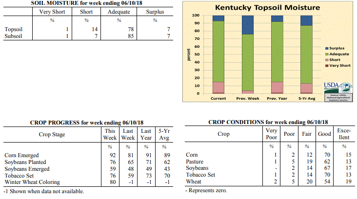 Kentucky Climate Summary
For the Period June 4 to June 10, 2018
Above Normal Temperatures and Below Normal Rainfall:
Through the first half of the work week, Kentucky saw dry, cooler, and noticeably
less humid conditions, resulting in quite the difference compared to past weeks.
Saying that, it turned into a rather short-lived break as heat and humidity returned
over the second half. Highs on Friday peaked in the upper 80s to low 90s statewide,
warmest temperatures across Western and Central Kentucky. This helped push the state
to a sixth straight week of temperatures averaging above normal. While mostly dry
conditions continued through Friday, an unstable atmosphere led to scattered to
numerous showers and storms over the weekend. The highest coverage was seen on
Sunday as multiple storm complexes progressed through Kentucky. Just like previous
weeks, heavy rainfall, lightning, and occasional gusty winds continued to be the main
hazards. Much of the rainfall on Sunday evening occurred after the data cut-off for
this period and will be reflected in the report next week.
Temperatures for the period averaged 73 degrees across the state which was 2 degrees
warmer than normal and 2 degrees cooler than the previous period. High temperatures
averaged from 88 in the West to 83 in the East. Departure from normal high
temperatures ranged from 4 degrees warmer than normal in the West to 1 degree
warmer than normal in the East. Low temperatures averaged from 64 degrees in the
West to 58 degrees in the East. Departure from normal low temperature ranged from 2
degrees warmer than normal in the West to 1 degree warmer than normal in the East.
The extreme high temperature for the period was 95 degrees at CAPE GIRARDEAU ASOS and
the extreme low was 49 degrees at CYNTHIANA 8N.
Precipitation (liq. equ.) for the period totaled 0.21 inches statewide which was 0.86
inches below normal and 20% of normal. Precipitation totals by climate division, West
0.26 inches, Central 0.12 inches, Bluegrass 0.23 inches and East 0.23 inches, which
was 0.76, 0.96, 0.86 and 0.85 inches below normal. By station, precipitation totals
ranged from a low of 0.00 inches at ALBANY 1N to a high of 1.25 inches at HENDERSON 5E.
---
Kentucky Crop and Weather Report
Issued 4:00 P.M., June 5, 2018 14-18
Agricultural News: Kentucky experienced above normal temperatures and much above
normal rainfall over the past week. Precipitation for the week totaled 1.86 inches,
0.75 inches above normal. Temperatures averaged 76 degrees for the week, 7 degrees
above normal. Topsoil moisture was rated 4 percent short, 72 percent adequate, and 24
percent surplus. Subsoil moisture was rated 2 percent short, 81 percent adequate, and
17 percent surplus. Days suitable for fieldwork averaged 3.3 out of a possible seven.
Primary activities for this week included planting corn and soybeans along with
tobacco setting when the weather allowed. Fieldwork progress was stunted as hot
weather brought several rounds of rain. Some areas in the state received very heavy
rain leading to standing water in fields. Even with the recurring precipitation, corn
planting is nearing completion with 94 percent in the ground. Farmers sprayed the
corn crop when there were opportunities between rain showers. The average height of
corn was 14 inches, compared to 9 inches last week.
Pastures continue to be in mostly good condition and are improving in many areas of
the state. The hay harvest is behind at this juncture, but with favorable weather a
recovery is possible.
Kentucky Climate Summary
For the Period June 4 to June 10, 2018
Above Normal Temperatures and Below Normal Rainfall:
Through the first half of the work week, Kentucky saw dry, cooler, and noticeably
less humid conditions, resulting in quite the difference compared to past weeks.
Saying that, it turned into a rather short-lived break as heat and humidity returned
over the second half. Highs on Friday peaked in the upper 80s to low 90s statewide,
warmest temperatures across Western and Central Kentucky. This helped push the state
to a sixth straight week of temperatures averaging above normal. While mostly dry
conditions continued through Friday, an unstable atmosphere led to scattered to
numerous showers and storms over the weekend. The highest coverage was seen on
Sunday as multiple storm complexes progressed through Kentucky. Just like previous
weeks, heavy rainfall, lightning, and occasional gusty winds continued to be the main
hazards. Much of the rainfall on Sunday evening occurred after the data cut-off for
this period and will be reflected in the report next week.
Temperatures for the period averaged 73 degrees across the state which was 2 degrees
warmer than normal and 2 degrees cooler than the previous period. High temperatures
averaged from 88 in the West to 83 in the East. Departure from normal high
temperatures ranged from 4 degrees warmer than normal in the West to 1 degree
warmer than normal in the East. Low temperatures averaged from 64 degrees in the
West to 58 degrees in the East. Departure from normal low temperature ranged from 2
degrees warmer than normal in the West to 1 degree warmer than normal in the East.
The extreme high temperature for the period was 95 degrees at CAPE GIRARDEAU ASOS and
the extreme low was 49 degrees at CYNTHIANA 8N.
Precipitation (liq. equ.) for the period totaled 0.21 inches statewide which was 0.86
inches below normal and 20% of normal. Precipitation totals by climate division, West
0.26 inches, Central 0.12 inches, Bluegrass 0.23 inches and East 0.23 inches, which
was 0.76, 0.96, 0.86 and 0.85 inches below normal. By station, precipitation totals
ranged from a low of 0.00 inches at ALBANY 1N to a high of 1.25 inches at HENDERSON 5E.
---
Kentucky Crop and Weather Report
Issued 4:00 P.M., June 5, 2018 14-18
Agricultural News: Kentucky experienced above normal temperatures and much above
normal rainfall over the past week. Precipitation for the week totaled 1.86 inches,
0.75 inches above normal. Temperatures averaged 76 degrees for the week, 7 degrees
above normal. Topsoil moisture was rated 4 percent short, 72 percent adequate, and 24
percent surplus. Subsoil moisture was rated 2 percent short, 81 percent adequate, and
17 percent surplus. Days suitable for fieldwork averaged 3.3 out of a possible seven.
Primary activities for this week included planting corn and soybeans along with
tobacco setting when the weather allowed. Fieldwork progress was stunted as hot
weather brought several rounds of rain. Some areas in the state received very heavy
rain leading to standing water in fields. Even with the recurring precipitation, corn
planting is nearing completion with 94 percent in the ground. Farmers sprayed the
corn crop when there were opportunities between rain showers. The average height of
corn was 14 inches, compared to 9 inches last week.
Pastures continue to be in mostly good condition and are improving in many areas of
the state. The hay harvest is behind at this juncture, but with favorable weather a
recovery is possible.
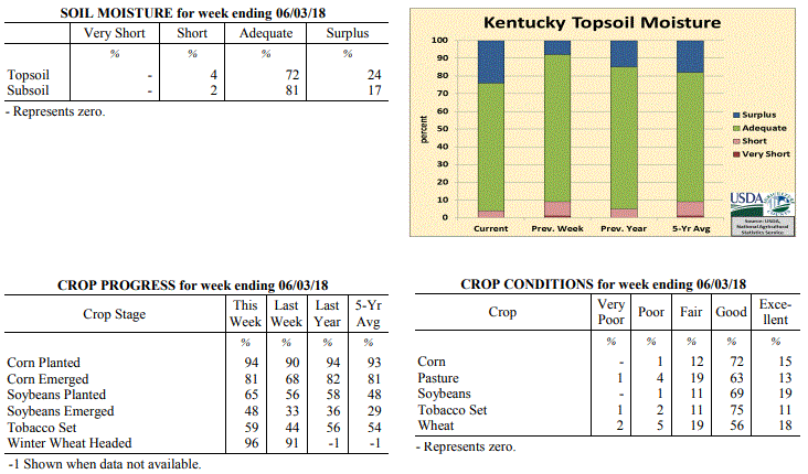 Kentucky Climate Summary
For the Period May 28 to June 3, 2018
Above Normal Temperatures and Much Above Normal Rainfall:
It may be early in the year to be talking about tropical storms, but Kentucky had to
deal with the remnants of Subtropical Depression Alberto early in the period. Outer
bands on the north side of Alberto started affecting the region on Monday with
scattered to numerous showers/storms in place. More of the same followed on Tuesday
and Wednesday as the remnants passed through Western Kentucky and north of the
region. A very moist atmosphere in place with dew points in the 70s led storms
producing torrential rainfall at times and in turn, localized flash flooding. While
the state had already seen an abundant amount of rainfall, more rounds followed over
the second half of the period, highlighted by a passing disturbance on Thursday with
a couple rounds of strong to severe storms. While heavy rain and flooding continued
to be an issue, these storms also produced damaging winds across much of the state.
Overall, the state averaged nearly two inches for the week, but several locations
across Western and Central Kentucky saw more than three. As a side note,
temperatures continued to run above normal and based on preliminary data at the UK Ag
Weather Center, this past month would be the warmest May on record for the state of
Kentucky.
Temperatures for the period averaged 76 degrees across the state which was 7 degrees
warmer than normal and 2 degrees warmer than the previous period. High temperatures
averaged from 86 in the West to 82 in the East. Departure from normal high
temperatures ranged from 4 degrees warmer than normal in the West to 2 degrees
warmer than normal in the East. Low temperatures averaged from 69 degrees in the
West to 66 degrees in the East. Departure from normal low temperature ranged from 9
degrees warmer than normal in the West to 11 degrees warmer than normal in the
East. The extreme high temperature for the period was 92 degrees at EVANSVILLE ASOS
and the extreme low was 61 degrees at PAINTSVILLE 4W.
Precipitation (liq. equ.) for the period totaled 1.86 inches statewide which was 0.75
inches above normal and 167% of normal. Precipitation totals by climate division,
West 2.48 inches, Central 2.14 inches, Bluegrass 1.54 inches and East 1.28 inches,
which was 1.39, 0.99, 0.45 and 0.16 inches above normal. By station, precipitation
totals ranged from a low of 0.23 inches at POPLAR BLUFF ASOS to a high of 5.77
inches at HOPKINSVILLE 6N.
---
Kentucky Crop and Weather Report
Issued 4:00 P.M., May 29, 2018 13-18
Agricultural News: Kentucky experienced well above normal temperatures and below
normal rainfall over the past week. Precipitation for the week totaled 0.88 inches,
0.23 inches below normal. Temperatures averaged 74 degrees for the week, 7 degrees
above normal. Topsoil moisture was rated 1 percent very short, 8 percent short, 83
percent adequate, and 8 percent surplus. Subsoil moisture was rated 1 percent very
short, 5 percent short, 88 percent adequate, and 6 percent surplus. Days suitable for
fieldwork averaged 5.0 out of a possible seven.
Primary activities for this week included planting corn, soybeans, and tobacco along
with cutting hay and spraying. Although there was some rain this week, farmers were
still able to make steady progress on field work. Corn planting was on par with last
year while soybeans and tobacco are slightly ahead of 2017 for this juncture in the
season. The average height of corn was 9 inches, matching last year. Winter wheat is
91 percent headed
Pasture and livestock are in mostly good condition at this time. Hay and roughage
supplies were reported as 4 percent very short, 20 percent short, 72 percent
adequate, and 4 percent surplus. The majority of hay was reported in good condition
although a few producers expressed yield concerns due to a very wet season and late
first cuttings.
Kentucky Climate Summary
For the Period May 28 to June 3, 2018
Above Normal Temperatures and Much Above Normal Rainfall:
It may be early in the year to be talking about tropical storms, but Kentucky had to
deal with the remnants of Subtropical Depression Alberto early in the period. Outer
bands on the north side of Alberto started affecting the region on Monday with
scattered to numerous showers/storms in place. More of the same followed on Tuesday
and Wednesday as the remnants passed through Western Kentucky and north of the
region. A very moist atmosphere in place with dew points in the 70s led storms
producing torrential rainfall at times and in turn, localized flash flooding. While
the state had already seen an abundant amount of rainfall, more rounds followed over
the second half of the period, highlighted by a passing disturbance on Thursday with
a couple rounds of strong to severe storms. While heavy rain and flooding continued
to be an issue, these storms also produced damaging winds across much of the state.
Overall, the state averaged nearly two inches for the week, but several locations
across Western and Central Kentucky saw more than three. As a side note,
temperatures continued to run above normal and based on preliminary data at the UK Ag
Weather Center, this past month would be the warmest May on record for the state of
Kentucky.
Temperatures for the period averaged 76 degrees across the state which was 7 degrees
warmer than normal and 2 degrees warmer than the previous period. High temperatures
averaged from 86 in the West to 82 in the East. Departure from normal high
temperatures ranged from 4 degrees warmer than normal in the West to 2 degrees
warmer than normal in the East. Low temperatures averaged from 69 degrees in the
West to 66 degrees in the East. Departure from normal low temperature ranged from 9
degrees warmer than normal in the West to 11 degrees warmer than normal in the
East. The extreme high temperature for the period was 92 degrees at EVANSVILLE ASOS
and the extreme low was 61 degrees at PAINTSVILLE 4W.
Precipitation (liq. equ.) for the period totaled 1.86 inches statewide which was 0.75
inches above normal and 167% of normal. Precipitation totals by climate division,
West 2.48 inches, Central 2.14 inches, Bluegrass 1.54 inches and East 1.28 inches,
which was 1.39, 0.99, 0.45 and 0.16 inches above normal. By station, precipitation
totals ranged from a low of 0.23 inches at POPLAR BLUFF ASOS to a high of 5.77
inches at HOPKINSVILLE 6N.
---
Kentucky Crop and Weather Report
Issued 4:00 P.M., May 29, 2018 13-18
Agricultural News: Kentucky experienced well above normal temperatures and below
normal rainfall over the past week. Precipitation for the week totaled 0.88 inches,
0.23 inches below normal. Temperatures averaged 74 degrees for the week, 7 degrees
above normal. Topsoil moisture was rated 1 percent very short, 8 percent short, 83
percent adequate, and 8 percent surplus. Subsoil moisture was rated 1 percent very
short, 5 percent short, 88 percent adequate, and 6 percent surplus. Days suitable for
fieldwork averaged 5.0 out of a possible seven.
Primary activities for this week included planting corn, soybeans, and tobacco along
with cutting hay and spraying. Although there was some rain this week, farmers were
still able to make steady progress on field work. Corn planting was on par with last
year while soybeans and tobacco are slightly ahead of 2017 for this juncture in the
season. The average height of corn was 9 inches, matching last year. Winter wheat is
91 percent headed
Pasture and livestock are in mostly good condition at this time. Hay and roughage
supplies were reported as 4 percent very short, 20 percent short, 72 percent
adequate, and 4 percent surplus. The majority of hay was reported in good condition
although a few producers expressed yield concerns due to a very wet season and late
first cuttings.
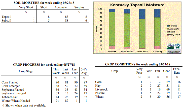 Kentucky Climate Summary
For the Period May 21 to May 27, 2018
Well Above Normal Temperatures and Below Normal Rainfall:
Kentucky remained situated within a hot and humid air mass this past week. High
temperatures continued to run solidly in the 80s, topping out Friday and into the
weekend with the majority of the state in the middle 80s to around 90. Normal high
temperatures for late May run in the upper 70s to low 80s. The state has now gone
four straight weeks with above normal temperatures in place. Just like the previous
period, the Bluegrass State saw scattered showers and storms develop during the
afternoon and evening hours throughout much of the week. With a very moist air mass
in place, heavy down pours continued to be an issue, in addition to frequent
lightning and gusty winds at times. Overall, the state averaged 0.88 inches, but that
number may be a bit misleading as the scattered nature led to a wide range of
accumulations. While some received less than a quarter inch for the week,
others saw in excess of two.
Temperatures for the period averaged 74 degrees across the state which was 7 degrees
warmer than normal and no change to the previous period. High temperatures averaged
from 86 in the West to 83 in the East. Departure from normal high temperatures
ranged from 6 degrees warmer than normal in the West to 5 degrees warmer than normal
in the East. Low temperatures averaged from 66 degrees in the West to 64 degrees in
the East. Departure from normal low temperature ranged from 9 degrees warmer than
normal in the West to 12 degrees warmer than normal in the East. The extreme high
temperature for the period was 94 degrees at EVANSVILLE ASOS and the extreme low was
53 degrees at BLACK MOUNTAIN ARC.
Precipitation (liq. equ.) for the period totaled 0.88 inches statewide which was 0.23
inches below normal and 79% of normal. Precipitation totals by climate division, West
0.54 inches, Central 0.85 inches, Bluegrass 1.02 inches and East 1.11 inches, which
was 0.56, 0.31, 0.05 and 0.01 inches below normal. By station, precipitation totals
ranged from a low of 0.03 inches at GREENVILLE 6N to a high of 3.23 inches at MOREHEAD 4NE.
---
Kentucky Crop and Weather Report
Issued 4:00 P.M., May 21, 2018 12-18
Agricultural News: Kentucky experienced well above normal temperatures and above
normal rainfall over the past week. Precipitation for the week totaled 1.23 inches,
0.09 inches above normal. Temperatures averaged 74 degrees for the week, 9 degrees
above normal. Topsoil moisture was rated 1 percent very short, 5 percent short, 83
percent adequate and 11 percent surplus. Subsoil moisture was rated 3 percent short,
88 percent adequate, and 9 percent surplus. Days suitable for fieldwork averaged 5.0
out of a possible seven.
Primary activities this week included planting corn and soybeans, setting tobacco,
and spraying fields. Periodic afternoon rainfall postponed fieldwork at times.
Tobacco transplant supplies were reported as 2 percent short, 91 percent adequate,
and 7 percent surplus.
Hay cutting continued this week for areas that experienced good drying conditions,
although producers are noting lower yields. Scattered thunderstorms delayed some
farmers from fieldwork, mostly in far eastern and western counties where
precipitation totals were higher. There are concerns of forages becoming over mature
and leading to lower quality, due to rainfall delays in cutting. Spring breeding of
cattle is underway.
Kentucky Climate Summary
For the Period May 21 to May 27, 2018
Well Above Normal Temperatures and Below Normal Rainfall:
Kentucky remained situated within a hot and humid air mass this past week. High
temperatures continued to run solidly in the 80s, topping out Friday and into the
weekend with the majority of the state in the middle 80s to around 90. Normal high
temperatures for late May run in the upper 70s to low 80s. The state has now gone
four straight weeks with above normal temperatures in place. Just like the previous
period, the Bluegrass State saw scattered showers and storms develop during the
afternoon and evening hours throughout much of the week. With a very moist air mass
in place, heavy down pours continued to be an issue, in addition to frequent
lightning and gusty winds at times. Overall, the state averaged 0.88 inches, but that
number may be a bit misleading as the scattered nature led to a wide range of
accumulations. While some received less than a quarter inch for the week,
others saw in excess of two.
Temperatures for the period averaged 74 degrees across the state which was 7 degrees
warmer than normal and no change to the previous period. High temperatures averaged
from 86 in the West to 83 in the East. Departure from normal high temperatures
ranged from 6 degrees warmer than normal in the West to 5 degrees warmer than normal
in the East. Low temperatures averaged from 66 degrees in the West to 64 degrees in
the East. Departure from normal low temperature ranged from 9 degrees warmer than
normal in the West to 12 degrees warmer than normal in the East. The extreme high
temperature for the period was 94 degrees at EVANSVILLE ASOS and the extreme low was
53 degrees at BLACK MOUNTAIN ARC.
Precipitation (liq. equ.) for the period totaled 0.88 inches statewide which was 0.23
inches below normal and 79% of normal. Precipitation totals by climate division, West
0.54 inches, Central 0.85 inches, Bluegrass 1.02 inches and East 1.11 inches, which
was 0.56, 0.31, 0.05 and 0.01 inches below normal. By station, precipitation totals
ranged from a low of 0.03 inches at GREENVILLE 6N to a high of 3.23 inches at MOREHEAD 4NE.
---
Kentucky Crop and Weather Report
Issued 4:00 P.M., May 21, 2018 12-18
Agricultural News: Kentucky experienced well above normal temperatures and above
normal rainfall over the past week. Precipitation for the week totaled 1.23 inches,
0.09 inches above normal. Temperatures averaged 74 degrees for the week, 9 degrees
above normal. Topsoil moisture was rated 1 percent very short, 5 percent short, 83
percent adequate and 11 percent surplus. Subsoil moisture was rated 3 percent short,
88 percent adequate, and 9 percent surplus. Days suitable for fieldwork averaged 5.0
out of a possible seven.
Primary activities this week included planting corn and soybeans, setting tobacco,
and spraying fields. Periodic afternoon rainfall postponed fieldwork at times.
Tobacco transplant supplies were reported as 2 percent short, 91 percent adequate,
and 7 percent surplus.
Hay cutting continued this week for areas that experienced good drying conditions,
although producers are noting lower yields. Scattered thunderstorms delayed some
farmers from fieldwork, mostly in far eastern and western counties where
precipitation totals were higher. There are concerns of forages becoming over mature
and leading to lower quality, due to rainfall delays in cutting. Spring breeding of
cattle is underway.
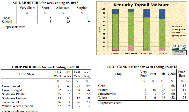 Kentucky Climate Summary
For the Period May 14 to May 20, 2018
Well Above Normal Temperatures and Above Normal Rainfall:
A summerlike pattern continued for a second straight week, but unlike the previous
period, Kentucky saw daily rounds of showers and storms. Each day was a near replay
of the previous as scattered showers and storms fired each afternoon and evening,
before diminishing overnight. While coverage was not widespread, much of Kentucky
still managed to pick up more than inch for the week. This was mostly due to the
very moist and unstable atmosphere in place, which led to torrential rainfall at
times and in turn, localized flooding. Temperatures remained very warm for this time
of year, peaking early in the week. Kentucky saw record heat on Monday as highs
pushed into the upper 80s to low 90s statewide.
Temperatures for the period averaged 74 degrees across the state which was 9 degrees
warmer than normal and 4 degrees warmer than the previous period. High temperatures
averaged from 85 in the West to 83 in the East. Departure from normal high
temperatures ranged from 7 degrees warmer than normal in the West to 6 degrees
warmer than normal in the East. Low temperatures averaged from 65 degrees in the
West to 63 degrees in the East. Departure from normal low temperature ranged from 10
degrees warmer than normal in the West to 13 degrees warmer than normal in the
East. The extreme high temperature for the period was 93 degrees at HENDERSON 5E and
the extreme low was 58 degrees at BARBOURVILLE 3E.
Precipitation (liq. equ.) for the period totaled 1.23 inches statewide which was 0.09
inches above normal and 108% of normal. Precipitation totals by climate division,
West 1.35 inches, Central 0.71 inches, Bluegrass 1.57 inches and East 1.29 inches,
which was 0.19, -0.48, 0.49 and 0.18 inches respectively from normal. By station,
precipitation totals ranged from a low of 0.24 inches at HARDINSBURG 5SW to a high of
3.19 inches at MOREHEAD 4NE.
---
Kentucky Crop and Weather Report
Issued 4:00 P.M., May 14, 2018 11-18
Agricultural News: Kentucky experienced well above normal temperatures and below
normal rainfall over the past week. Precipitation for the week totaled 0.15 inches,
0.95 inches below normal. Temperatures averaged 71 degrees for the week, 8 degrees
above normal. Topsoil moisture was rated 13 percent short, 81 percent adequate and 6
percent surplus. Subsoil moisture was rated 5 percent short, 86 percent adequate, and
9 percent surplus. Days suitable for fieldwork averaged 6.0 out of a possible seven.
Primary activities this week included planting corn, soybeans, and vegetables,
setting tobacco, cutting hay, and fertilizing fields. Initial reports from some
producers note that first cutting hay yields are poor due to the late spring.
Favorable warm and dry weather over the past week helped to improve pastures and hay,
and allowed for significant planting progress to be made. Weather forecasts for rain
in the next week have delayed some farmers from cutting hay to allow for enough time
to bale. Cattle producers are preparing for spring breeding.
Tobacco transplant supplies were reported as 2 percent short, 90 percent adequate,
and 8 percent surplus. Eighteen percent of tobacco transplants were under 2 inches,
with 43 percent between 2-4 inches, and 39 percent
over 4 inches.
Kentucky Climate Summary
For the Period May 14 to May 20, 2018
Well Above Normal Temperatures and Above Normal Rainfall:
A summerlike pattern continued for a second straight week, but unlike the previous
period, Kentucky saw daily rounds of showers and storms. Each day was a near replay
of the previous as scattered showers and storms fired each afternoon and evening,
before diminishing overnight. While coverage was not widespread, much of Kentucky
still managed to pick up more than inch for the week. This was mostly due to the
very moist and unstable atmosphere in place, which led to torrential rainfall at
times and in turn, localized flooding. Temperatures remained very warm for this time
of year, peaking early in the week. Kentucky saw record heat on Monday as highs
pushed into the upper 80s to low 90s statewide.
Temperatures for the period averaged 74 degrees across the state which was 9 degrees
warmer than normal and 4 degrees warmer than the previous period. High temperatures
averaged from 85 in the West to 83 in the East. Departure from normal high
temperatures ranged from 7 degrees warmer than normal in the West to 6 degrees
warmer than normal in the East. Low temperatures averaged from 65 degrees in the
West to 63 degrees in the East. Departure from normal low temperature ranged from 10
degrees warmer than normal in the West to 13 degrees warmer than normal in the
East. The extreme high temperature for the period was 93 degrees at HENDERSON 5E and
the extreme low was 58 degrees at BARBOURVILLE 3E.
Precipitation (liq. equ.) for the period totaled 1.23 inches statewide which was 0.09
inches above normal and 108% of normal. Precipitation totals by climate division,
West 1.35 inches, Central 0.71 inches, Bluegrass 1.57 inches and East 1.29 inches,
which was 0.19, -0.48, 0.49 and 0.18 inches respectively from normal. By station,
precipitation totals ranged from a low of 0.24 inches at HARDINSBURG 5SW to a high of
3.19 inches at MOREHEAD 4NE.
---
Kentucky Crop and Weather Report
Issued 4:00 P.M., May 14, 2018 11-18
Agricultural News: Kentucky experienced well above normal temperatures and below
normal rainfall over the past week. Precipitation for the week totaled 0.15 inches,
0.95 inches below normal. Temperatures averaged 71 degrees for the week, 8 degrees
above normal. Topsoil moisture was rated 13 percent short, 81 percent adequate and 6
percent surplus. Subsoil moisture was rated 5 percent short, 86 percent adequate, and
9 percent surplus. Days suitable for fieldwork averaged 6.0 out of a possible seven.
Primary activities this week included planting corn, soybeans, and vegetables,
setting tobacco, cutting hay, and fertilizing fields. Initial reports from some
producers note that first cutting hay yields are poor due to the late spring.
Favorable warm and dry weather over the past week helped to improve pastures and hay,
and allowed for significant planting progress to be made. Weather forecasts for rain
in the next week have delayed some farmers from cutting hay to allow for enough time
to bale. Cattle producers are preparing for spring breeding.
Tobacco transplant supplies were reported as 2 percent short, 90 percent adequate,
and 8 percent surplus. Eighteen percent of tobacco transplants were under 2 inches,
with 43 percent between 2-4 inches, and 39 percent
over 4 inches.
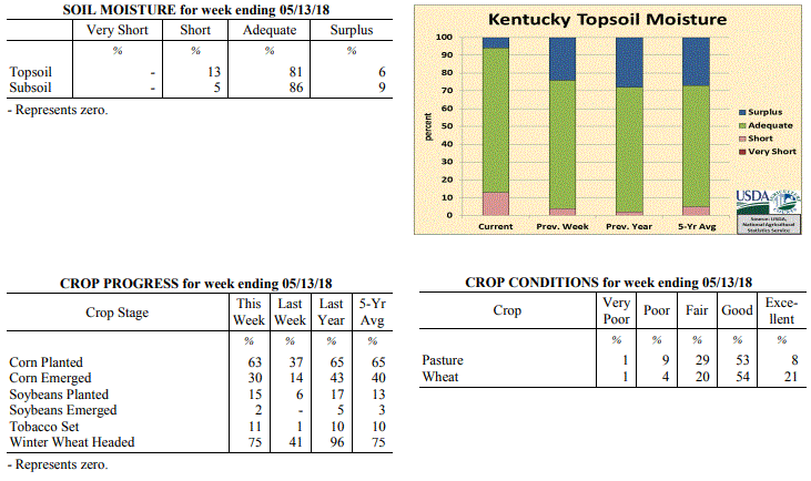 Kentucky Climate Summary
For the Period May 7 to May 13, 2018
Well Above Normal Temperatures and Below Normal Rainfall:
It might be a month early, but it felt more like summer for much of the period.
Temperatures and humidity gradually increased throughout the week. The Bluegrass
State started with highs in the upper 60s to middle 70s on Monday and ended with
middle 80s to low 90s on Sunday. The livestock heat stress index even increased into
the danger category for short time periods late in the week during the afternoon and
early evening hours. The summerlike conditions led to the first time since late
February/early March that the Commonwealth had consecutive weeks of above normal
temperatures. Other than some occasional isolated showers and storms through the
workweek, Kentucky was dry for the majority of the period. In fact, the state was
almost an inch below normal for the week.
Temperatures for the period averaged 71 degrees across the state which was 8 degrees
warmer than normal and 4 degrees warmer than the previous period. High temperatures
averaged from 84 in the West to 83 in the East. Departure from normal high
temperatures ranged from 8 degrees warmer than normal in the West to 8 degrees
warmer than normal in the East. Low temperatures averaged from 60 degrees in the
West to 58 degrees in the East. Departure from normal low temperature ranged from 7
degrees warmer than normal in the West to 11 degrees warmer than normal in the
East. The extreme high temperature for the period was 91 degrees at MAYFIELD 6SW and
the extreme low was 43 degrees at BRANDENBURG 4SW.
Precipitation (liq. equ.) for the period totaled 0.15 inches statewide which was 0.95
inches below normal and 14% of normal. Precipitation totals by climate division, West
0.10 inches, Central 0.22 inches, Bluegrass 0.11 inches and East 0.17 inches, which
was 1.06, 0.94, 0.91 and 0.89 inches below normal. By station, precipitation totals
ranged from a low of 0.00 inches at BENTON 4N to a high of 0.62 inches at MUNFORDVILLE 6E.
---
Kentucky Crop and Weather Report
Issued 4:00 P.M., May 7, 2018 10-18
Agricultural News: Kentucky experienced above normal temperatures and rainfall over
the past week. Precipitation for the week totaled 1.33 inches, 0.24 inches above
normal. Temperatures averaged 66 degrees for the week, 5 degrees above normal.
Topsoil moisture was rated 4 percent short, 72 percent adequate and 24 percent
surplus. Subsoil moisture was rated 1 percent short, 76 percent adequate, and 23
percent surplus. Days suitable for fieldwork averaged 5.0 out of a possible seven.
Rising temperatures helped in drying out fields this week. Primary activities
included planting corn and soybeans, setting tobacco, as well as spraying,
fertilizing, and field preparations. Rain and scattered storms over the weekend did
limit fieldwork.
Overall, the wet and cool start to spring has led to several issues including short
and thin hay, little stem elongation in wheat heads, slugs in wheat fields, and poor
emergence in corn. Some corn fields are being replanted as a result. Pastures and
forages are growing faster from the recent warmer temperatures.
Tobacco transplant supplies were reported as 2 percent short, 90 percent adequate,
and 8 percent surplus. Twenty-six percent of tobacco transplants were under 2 inches,
with 43 percent between 2-4 inches, and 31 percent
over 4 inches.
Kentucky Climate Summary
For the Period May 7 to May 13, 2018
Well Above Normal Temperatures and Below Normal Rainfall:
It might be a month early, but it felt more like summer for much of the period.
Temperatures and humidity gradually increased throughout the week. The Bluegrass
State started with highs in the upper 60s to middle 70s on Monday and ended with
middle 80s to low 90s on Sunday. The livestock heat stress index even increased into
the danger category for short time periods late in the week during the afternoon and
early evening hours. The summerlike conditions led to the first time since late
February/early March that the Commonwealth had consecutive weeks of above normal
temperatures. Other than some occasional isolated showers and storms through the
workweek, Kentucky was dry for the majority of the period. In fact, the state was
almost an inch below normal for the week.
Temperatures for the period averaged 71 degrees across the state which was 8 degrees
warmer than normal and 4 degrees warmer than the previous period. High temperatures
averaged from 84 in the West to 83 in the East. Departure from normal high
temperatures ranged from 8 degrees warmer than normal in the West to 8 degrees
warmer than normal in the East. Low temperatures averaged from 60 degrees in the
West to 58 degrees in the East. Departure from normal low temperature ranged from 7
degrees warmer than normal in the West to 11 degrees warmer than normal in the
East. The extreme high temperature for the period was 91 degrees at MAYFIELD 6SW and
the extreme low was 43 degrees at BRANDENBURG 4SW.
Precipitation (liq. equ.) for the period totaled 0.15 inches statewide which was 0.95
inches below normal and 14% of normal. Precipitation totals by climate division, West
0.10 inches, Central 0.22 inches, Bluegrass 0.11 inches and East 0.17 inches, which
was 1.06, 0.94, 0.91 and 0.89 inches below normal. By station, precipitation totals
ranged from a low of 0.00 inches at BENTON 4N to a high of 0.62 inches at MUNFORDVILLE 6E.
---
Kentucky Crop and Weather Report
Issued 4:00 P.M., May 7, 2018 10-18
Agricultural News: Kentucky experienced above normal temperatures and rainfall over
the past week. Precipitation for the week totaled 1.33 inches, 0.24 inches above
normal. Temperatures averaged 66 degrees for the week, 5 degrees above normal.
Topsoil moisture was rated 4 percent short, 72 percent adequate and 24 percent
surplus. Subsoil moisture was rated 1 percent short, 76 percent adequate, and 23
percent surplus. Days suitable for fieldwork averaged 5.0 out of a possible seven.
Rising temperatures helped in drying out fields this week. Primary activities
included planting corn and soybeans, setting tobacco, as well as spraying,
fertilizing, and field preparations. Rain and scattered storms over the weekend did
limit fieldwork.
Overall, the wet and cool start to spring has led to several issues including short
and thin hay, little stem elongation in wheat heads, slugs in wheat fields, and poor
emergence in corn. Some corn fields are being replanted as a result. Pastures and
forages are growing faster from the recent warmer temperatures.
Tobacco transplant supplies were reported as 2 percent short, 90 percent adequate,
and 8 percent surplus. Twenty-six percent of tobacco transplants were under 2 inches,
with 43 percent between 2-4 inches, and 31 percent
over 4 inches.
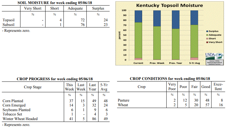 Kentucky Climate Summary
For the Period April 30 to May 6, 2018
Above Normal Temperatures and Rainfall:
The first couple days of May featured dry conditions and above normal temperatures
as high pressure took control of the Ohio Valley early in the period. By
Wednesday, high temperatures soared into the low to middle 80s behind breezy
southwest flow and it even felt a bit humid outside as dew points inched into the
60s. Showers and storms then returned for the latter half of the period, starting
with a weakening line of storms on Thursday morning pushing east. Scattered to
numerous showers and storms followed on Friday with the passage of a cold front,
before coverage turned widespread for Derby Day. In fact, Louisville International
Airport recorded over three inches for the one-day period on Saturday. After another
round of scattered storms Sunday afternoon/evening, Kentucky averaged 1.33 inches for
the week, marking the second straight period of above normal rainfall.
Temperatures for the period averaged 66 degrees across the state which was 5 degrees
warmer than normal and 8 degrees warmer than the previous period. High temperatures
averaged from 78 in the West to 78 in the East. Departure from normal high
temperatures ranged from 4 degrees warmer than normal in the West to 5 degrees
warmer than normal in the East. Low temperatures averaged from 57 degrees in the
West to 53 degrees in the East. Departure from normal low temperature ranged from 6
degrees warmer than normal in the West to 8 degrees warmer than normal in the East.
The extreme high temperature for the period was 90 degrees at LOUISA 1S and the
extreme low was 28 degrees at BOONEVILLE 2S.
Precipitation (liq. equ.) for the period totaled 1.33 inches statewide which was 0.24
inches above normal and 122% of normal. Precipitation totals by climate division,
West 1.02 inches, Central 1.59 inches, Bluegrass 1.49 inches and East 1.23 inches,
which was -0.19, 0.47, 0.49 and 0.21 inches respectively from normal. By station,
precipitation totals ranged from a low of 0.11 inches at YELLOW CREEK to a high of
3.20 inches at LOUISVILLE APT.
---
Kentucky Crop and Weather Report
Issued 4:00 P.M., April 30, 2018 09-18
Agricultural News: Kentucky experienced below normal temperatures and above normal
rainfall over the past week. Precipitation for the week totaled 1.16 inches, 0.11
inches above normal. Temperatures averaged 56 degrees for the week, 3 degrees below
normal. Topsoil moisture was rated 1 percent short, 67 percent adequate, and 32
percent surplus. Subsoil moisture was rated 65 percent adequate and 35 percent
surplus. Days suitable for fieldwork averaged 3.4 out of a possible seven.
Primary activities for this week included planting corn and soybeans when possible
along with seeding of tobacco transplants. Corn planting progress is well behind both
last year and the five year average for this point in the season due to continuing
rain and cool temperatures. Warm and dry conditions arrived towards the end of the
week and farmers will be trying to catch up while the weather holds out. Soybean
planting has just begun at 1 percent in the ground. The average height of winter
wheat was reported as 18 inches, compared to 17 inches last week.
Pastures and hay growth have suffered due to the consistent rain and cool
temperatures, however hay supply is mostly adequate and the condition is mostly good.
Hay supply was reported as 8 percent very short, 30 percent short, 59 percent
adequate, and 3 percent surplus. Alfalfa hay average height was 10 inches, compared
to 9 inches last week. Greenhouse tobacco plants were reported as in mostly good
condition. Forty three percent of tobacco transplants were under 2 inches, with 38
percent 2-4 inches, and 19 percent over 4 inches. Strawberry condition was rated as 1
percent very poor, 3 percent poor, 38 percent fair, 51 percent good, and 7 percent
excellent.
Kentucky Climate Summary
For the Period April 30 to May 6, 2018
Above Normal Temperatures and Rainfall:
The first couple days of May featured dry conditions and above normal temperatures
as high pressure took control of the Ohio Valley early in the period. By
Wednesday, high temperatures soared into the low to middle 80s behind breezy
southwest flow and it even felt a bit humid outside as dew points inched into the
60s. Showers and storms then returned for the latter half of the period, starting
with a weakening line of storms on Thursday morning pushing east. Scattered to
numerous showers and storms followed on Friday with the passage of a cold front,
before coverage turned widespread for Derby Day. In fact, Louisville International
Airport recorded over three inches for the one-day period on Saturday. After another
round of scattered storms Sunday afternoon/evening, Kentucky averaged 1.33 inches for
the week, marking the second straight period of above normal rainfall.
Temperatures for the period averaged 66 degrees across the state which was 5 degrees
warmer than normal and 8 degrees warmer than the previous period. High temperatures
averaged from 78 in the West to 78 in the East. Departure from normal high
temperatures ranged from 4 degrees warmer than normal in the West to 5 degrees
warmer than normal in the East. Low temperatures averaged from 57 degrees in the
West to 53 degrees in the East. Departure from normal low temperature ranged from 6
degrees warmer than normal in the West to 8 degrees warmer than normal in the East.
The extreme high temperature for the period was 90 degrees at LOUISA 1S and the
extreme low was 28 degrees at BOONEVILLE 2S.
Precipitation (liq. equ.) for the period totaled 1.33 inches statewide which was 0.24
inches above normal and 122% of normal. Precipitation totals by climate division,
West 1.02 inches, Central 1.59 inches, Bluegrass 1.49 inches and East 1.23 inches,
which was -0.19, 0.47, 0.49 and 0.21 inches respectively from normal. By station,
precipitation totals ranged from a low of 0.11 inches at YELLOW CREEK to a high of
3.20 inches at LOUISVILLE APT.
---
Kentucky Crop and Weather Report
Issued 4:00 P.M., April 30, 2018 09-18
Agricultural News: Kentucky experienced below normal temperatures and above normal
rainfall over the past week. Precipitation for the week totaled 1.16 inches, 0.11
inches above normal. Temperatures averaged 56 degrees for the week, 3 degrees below
normal. Topsoil moisture was rated 1 percent short, 67 percent adequate, and 32
percent surplus. Subsoil moisture was rated 65 percent adequate and 35 percent
surplus. Days suitable for fieldwork averaged 3.4 out of a possible seven.
Primary activities for this week included planting corn and soybeans when possible
along with seeding of tobacco transplants. Corn planting progress is well behind both
last year and the five year average for this point in the season due to continuing
rain and cool temperatures. Warm and dry conditions arrived towards the end of the
week and farmers will be trying to catch up while the weather holds out. Soybean
planting has just begun at 1 percent in the ground. The average height of winter
wheat was reported as 18 inches, compared to 17 inches last week.
Pastures and hay growth have suffered due to the consistent rain and cool
temperatures, however hay supply is mostly adequate and the condition is mostly good.
Hay supply was reported as 8 percent very short, 30 percent short, 59 percent
adequate, and 3 percent surplus. Alfalfa hay average height was 10 inches, compared
to 9 inches last week. Greenhouse tobacco plants were reported as in mostly good
condition. Forty three percent of tobacco transplants were under 2 inches, with 38
percent 2-4 inches, and 19 percent over 4 inches. Strawberry condition was rated as 1
percent very poor, 3 percent poor, 38 percent fair, 51 percent good, and 7 percent
excellent.
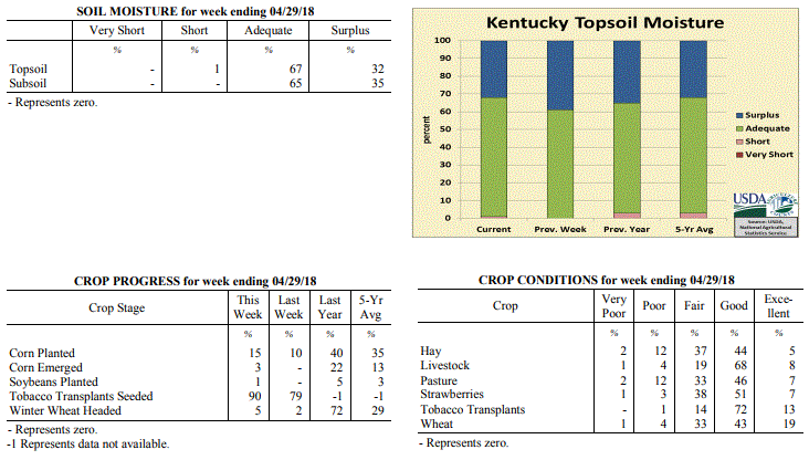 Kentucky Climate Summary
For the Period April 23 to April 29, 2018
Below Normal Temperatures and Above Normal Rainfall:
An area of low pressure aloft slowly progressed across the region to begin the
period. This kept Kentucky in a wet pattern with bands of light to moderate rain
showers moving through the area. In addition to some light rainfall on Thursday
across the southern half of Kentucky, total accumulations for the week averaged just
over an inch for the state. The clouds and precipitation kept temperatures below
normal by day and above normal at night. Sunshine returned for the weekend, but a
frontal passage early on Saturday kept temperatures below normal as high pressure
filtered cooler air from Canada down into the Bluegrass State. In fact, lows on
Saturday night/Sunday morning dipped into the low to middle 30s across the eastern
half of Kentucky, leading to some patchy light frost.
Temperatures for the period averaged 56 degrees across the state which was 3 degrees
cooler than normal and 6 degrees warmer than the previous period. High temperatures
averaged from 66 in the West to 64 in the East. Departure from normal high
temperatures ranged from 6 degrees cooler than normal in the West to 7 degrees cooler
than normal in the East. Low temperatures averaged from 49 degrees in the West to 48
degrees in the East. Departure from normal low temperature ranged from near normal in
the West to 5 degrees warmer than normal in the East. The extreme high temperature
for the period was 76 degrees at LOUISVILLE APT and the extreme low was 29 degrees at
BRANDENBURG 4SW.
Precipitation (liq. equ.) for the period totaled 1.16 inches statewide which was 0.11
inches above normal and 110% of normal. Precipitation totals by climate division,
West 1.45 inches, Central 0.98 inches, Bluegrass 1.07 inches and East 1.12 inches,
which was 0.25, -0.09, 0.10 and 0.15 inches respectively from normal. By station,
precipitation totals ranged from a low of 0.27 inches at FORT KNOX to a high of 3.42
inches at MAYFIELD 6SW.
---
Kentucky Crop and Weather Report
Issued 4:00 P.M., April 23, 2018 08-18
Agricultural News: Kentucky experienced below normal temperatures and precipitation
over the past week. Precipitation for the week totaled 0.29 inches, 0.70 inches below
normal. Temperatures averaged 50 degrees for the week, 6 degrees below normal.
Topsoil moisture was rated 61 percent adequate and 39 percent surplus. Subsoil
moisture was rated 65 percent adequate and 35 percent surplus. Days suitable for
fieldwork averaged 3.6 out of a possible seven.
Primary activities for this week included the continuation of corn planting and
tobacco transplant seeding. The weather continues to impede progress in the fields as
cool, wet conditions persist. Corn planting, at 10 percent, is well behind last year
at 28 percent, and the five year average of 21 percent. Sixty three percent of
tobacco transplants are under 2 inches, with 26 percent 2-4 inches, and 11 percent
over 4 inches. Soybean planting has been restricted by the weather and the lag in
corn planting progress.
The average height of winter wheat was 17 inches, up from 13 inches last week.
Average height of alfalfa hay was 9 inches, compared to 7 inches the previous week.
Apple freeze damage was reported as 2 percent severe, 11 percent moderate, 31 percent
light, and 56 percent with no damage. Peach freeze damage was reported as 4 percent
severe, 13 percent moderate, 32 percent light, and 51 percent with no damage.
Kentucky Climate Summary
For the Period April 23 to April 29, 2018
Below Normal Temperatures and Above Normal Rainfall:
An area of low pressure aloft slowly progressed across the region to begin the
period. This kept Kentucky in a wet pattern with bands of light to moderate rain
showers moving through the area. In addition to some light rainfall on Thursday
across the southern half of Kentucky, total accumulations for the week averaged just
over an inch for the state. The clouds and precipitation kept temperatures below
normal by day and above normal at night. Sunshine returned for the weekend, but a
frontal passage early on Saturday kept temperatures below normal as high pressure
filtered cooler air from Canada down into the Bluegrass State. In fact, lows on
Saturday night/Sunday morning dipped into the low to middle 30s across the eastern
half of Kentucky, leading to some patchy light frost.
Temperatures for the period averaged 56 degrees across the state which was 3 degrees
cooler than normal and 6 degrees warmer than the previous period. High temperatures
averaged from 66 in the West to 64 in the East. Departure from normal high
temperatures ranged from 6 degrees cooler than normal in the West to 7 degrees cooler
than normal in the East. Low temperatures averaged from 49 degrees in the West to 48
degrees in the East. Departure from normal low temperature ranged from near normal in
the West to 5 degrees warmer than normal in the East. The extreme high temperature
for the period was 76 degrees at LOUISVILLE APT and the extreme low was 29 degrees at
BRANDENBURG 4SW.
Precipitation (liq. equ.) for the period totaled 1.16 inches statewide which was 0.11
inches above normal and 110% of normal. Precipitation totals by climate division,
West 1.45 inches, Central 0.98 inches, Bluegrass 1.07 inches and East 1.12 inches,
which was 0.25, -0.09, 0.10 and 0.15 inches respectively from normal. By station,
precipitation totals ranged from a low of 0.27 inches at FORT KNOX to a high of 3.42
inches at MAYFIELD 6SW.
---
Kentucky Crop and Weather Report
Issued 4:00 P.M., April 23, 2018 08-18
Agricultural News: Kentucky experienced below normal temperatures and precipitation
over the past week. Precipitation for the week totaled 0.29 inches, 0.70 inches below
normal. Temperatures averaged 50 degrees for the week, 6 degrees below normal.
Topsoil moisture was rated 61 percent adequate and 39 percent surplus. Subsoil
moisture was rated 65 percent adequate and 35 percent surplus. Days suitable for
fieldwork averaged 3.6 out of a possible seven.
Primary activities for this week included the continuation of corn planting and
tobacco transplant seeding. The weather continues to impede progress in the fields as
cool, wet conditions persist. Corn planting, at 10 percent, is well behind last year
at 28 percent, and the five year average of 21 percent. Sixty three percent of
tobacco transplants are under 2 inches, with 26 percent 2-4 inches, and 11 percent
over 4 inches. Soybean planting has been restricted by the weather and the lag in
corn planting progress.
The average height of winter wheat was 17 inches, up from 13 inches last week.
Average height of alfalfa hay was 9 inches, compared to 7 inches the previous week.
Apple freeze damage was reported as 2 percent severe, 11 percent moderate, 31 percent
light, and 56 percent with no damage. Peach freeze damage was reported as 4 percent
severe, 13 percent moderate, 32 percent light, and 51 percent with no damage.
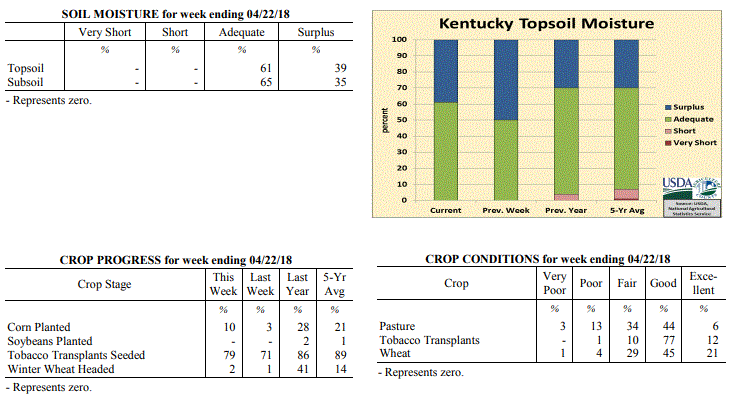 Kentucky Climate Summary
For the Period April 16 to April 22, 2018
Below Normal Temperatures and Precipitation:
Winter-like weather continues to make an appearance across the Bluegrass State. The
period started with well below normal temperatures on Monday and even some bursts of
intense snow showers that led to reduced visibilities at times. Lows that night
dipped into the upper 20s to low 30s, which produced some patchy areas of frost.
Temperatures quickly took a turn for the better on Tuesday and Wednesday with highs
back in the 60s and 70s behind breezy southwesterly winds. Another cold front then
moved through the area Wednesday and that night, producing a line of light to
moderate showers. Yet again, this sent temperatures below normal. More frost
followed the following couple of mornings, before warmth returned again over the
weekend. The period closed with an upper level disturbance moving into the Ohio
Valley on Sunday, producing showers across the southern half of the state. Overall,
the state averaged just over a quarter inch for the week.
Temperatures for the period averaged 50 degrees across the state which was 6 degrees
cooler than normal and 6 degrees cooler than the previous period. High temperatures
averaged from 63 in the West to 64 in the East. Departure from normal high
temperatures ranged from 7 degrees cooler than normal in the West to 5 degrees
cooler than normal in the East. Low temperatures averaged from 40 degrees in the
West to 36 degrees in the East. Departure from normal low temperature ranged from 7
degrees cooler than normal in the West to 5 degrees cooler than normal in the East.
The extreme high temperature for the period was 83 degrees at JACKSON and the extreme
low was 22 degrees at MONTICELLO AWOS.
Precipitation (liq. equ.) for the period totaled 0.29 inches statewide which was 0.7
inches below normal and 29% of normal. Precipitation totals by climate division, West
0.62 inches, Central 0.16 inches, Bluegrass 0.19 inches and East 0.19 inches, which
was 0.52, 0.83, 0.72 and 0.73 inches below normal. By station, precipitation totals
ranged from a low of 0.00 inches at CAMPBELLSVILLE 7W to a high of 1.74 inches at
MAYFIELD 6SW.
---
Kentucky Crop and Weather Report
Issued 4:00 P.M., April 16, 2018 07-18
Agricultural News: Kentucky experienced above normal temperatures and precipitation
over the past week. Precipitation for the week totaled 1.40 inches, 0.38 inches above
normal. Temperatures averaged 56 degrees for the week, 1 degree above normal. Topsoil
moisture was rated 50 percent adequate and 50 percent surplus. Subsoil moisture was
rated 55 percent adequate and 45 percent surplus. Days suitable for fieldwork
averaged 3.6 out of a possible seven.
Primary activities for this week included seeding of tobacco transplants, corn
planting, and fertilizer application when weather permitted. There were a few days
conducive to field work, however cold temperatures and rain returned for the weekend.
Corn planting continues to lag behind 2016 and 2017 at this juncture of the season.
Seventy-two percent of tobacco transplants were under 4 inches, with 24 percent 2-4
inches, and 4 percent above 4 inches.
The majority of winter wheat and alfalfa were not subjected to freeze damage. Winter
wheat freeze damage was reported as 2 percent moderate, 20 percent light, and 78
percent experiencing none. The average height of winter wheat was 13 inches. Alfalfa
freeze damage was reported as 1 percent severe, 12 percent moderate, 33 percent
light, and 54 percent experiencing none. The average height of alfalfa was 7 inches.
The return of rain and cold temperatures is taking a toll on pastures and some producers
reported a shortage of hay.
Kentucky Climate Summary
For the Period April 16 to April 22, 2018
Below Normal Temperatures and Precipitation:
Winter-like weather continues to make an appearance across the Bluegrass State. The
period started with well below normal temperatures on Monday and even some bursts of
intense snow showers that led to reduced visibilities at times. Lows that night
dipped into the upper 20s to low 30s, which produced some patchy areas of frost.
Temperatures quickly took a turn for the better on Tuesday and Wednesday with highs
back in the 60s and 70s behind breezy southwesterly winds. Another cold front then
moved through the area Wednesday and that night, producing a line of light to
moderate showers. Yet again, this sent temperatures below normal. More frost
followed the following couple of mornings, before warmth returned again over the
weekend. The period closed with an upper level disturbance moving into the Ohio
Valley on Sunday, producing showers across the southern half of the state. Overall,
the state averaged just over a quarter inch for the week.
Temperatures for the period averaged 50 degrees across the state which was 6 degrees
cooler than normal and 6 degrees cooler than the previous period. High temperatures
averaged from 63 in the West to 64 in the East. Departure from normal high
temperatures ranged from 7 degrees cooler than normal in the West to 5 degrees
cooler than normal in the East. Low temperatures averaged from 40 degrees in the
West to 36 degrees in the East. Departure from normal low temperature ranged from 7
degrees cooler than normal in the West to 5 degrees cooler than normal in the East.
The extreme high temperature for the period was 83 degrees at JACKSON and the extreme
low was 22 degrees at MONTICELLO AWOS.
Precipitation (liq. equ.) for the period totaled 0.29 inches statewide which was 0.7
inches below normal and 29% of normal. Precipitation totals by climate division, West
0.62 inches, Central 0.16 inches, Bluegrass 0.19 inches and East 0.19 inches, which
was 0.52, 0.83, 0.72 and 0.73 inches below normal. By station, precipitation totals
ranged from a low of 0.00 inches at CAMPBELLSVILLE 7W to a high of 1.74 inches at
MAYFIELD 6SW.
---
Kentucky Crop and Weather Report
Issued 4:00 P.M., April 16, 2018 07-18
Agricultural News: Kentucky experienced above normal temperatures and precipitation
over the past week. Precipitation for the week totaled 1.40 inches, 0.38 inches above
normal. Temperatures averaged 56 degrees for the week, 1 degree above normal. Topsoil
moisture was rated 50 percent adequate and 50 percent surplus. Subsoil moisture was
rated 55 percent adequate and 45 percent surplus. Days suitable for fieldwork
averaged 3.6 out of a possible seven.
Primary activities for this week included seeding of tobacco transplants, corn
planting, and fertilizer application when weather permitted. There were a few days
conducive to field work, however cold temperatures and rain returned for the weekend.
Corn planting continues to lag behind 2016 and 2017 at this juncture of the season.
Seventy-two percent of tobacco transplants were under 4 inches, with 24 percent 2-4
inches, and 4 percent above 4 inches.
The majority of winter wheat and alfalfa were not subjected to freeze damage. Winter
wheat freeze damage was reported as 2 percent moderate, 20 percent light, and 78
percent experiencing none. The average height of winter wheat was 13 inches. Alfalfa
freeze damage was reported as 1 percent severe, 12 percent moderate, 33 percent
light, and 54 percent experiencing none. The average height of alfalfa was 7 inches.
The return of rain and cold temperatures is taking a toll on pastures and some producers
reported a shortage of hay.
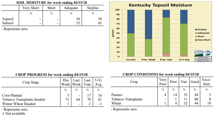 Kentucky Climate Summary
For the Period April 9 to April 15, 2018
Above Normal Temperatures and Precipitation:
High pressure kept the area dry through the workweek, but with a large swing in
temperatures. With the center of the high situated east of the state on Monday and
Tuesday, northerly flow kept temperatures well below normal. Lows dropped into the
upper 20s to middle 30s on Tuesday night, prompting Freeze Warnings and Frost
Advisories to be issued. As the high moved east of Kentucky on Wednesday, breezy
southwest flow led to an abrupt warm up across the area, eventually hitting the upper
70s to low 80s on Friday. While it did get warm, a combination of high winds, low
humidity, and dry fuels did lead to some fire weather concerns. Kentucky soils did
get a chance to dry out through Friday, but rounds of rainfall returned over the
weekend. A light and steady rainfall led to a soaking 1 to 2+ inches for
most of Kentucky. Overall, the state averaged 1.40 inches, which led to a fourth
straight week of above normal rainfall.
Temperatures for the period averaged 56 degrees across the state which was 1 degree
warmer than normal and 12 degrees warmer than the previous period. High temperatures
averaged from 65 in the West to 68 in the East. Departure from normal high
temperatures ranged from 4 degrees cooler than normal in the West to near normal in
the East. Low temperatures averaged from 46 degrees in the West to 44 degrees in the
East. Departure from normal low temperature ranged from 1 degree warmer than normal
in the West to 4 degrees warmer than normal in the East. The extreme high temperature
for the period was 86 degrees at LOUISA 1S and the extreme low was 24 degrees at
BRANDENBURG 4SW.
Precipitation (liq. equ.) for the period totaled 1.40 inches statewide which was 0.38
inches above normal and 137% of normal. Precipitation totals by climate division,
West 1.56 inches, Central 1.41 inches, Bluegrass 1.37 inches and East 1.27 inches,
which was 0.4, 0.37, 0.44 and 0.32 inches above normal. By station, precipitation
totals ranged from a low of 0.04 inches at MONTICELLO AWOS to a high of 3.34
inches at WHITLEY CITY 3N.
---
Kentucky Crop and Weather Report
Issued 4:00 P.M., April 9, 2018 06-18
Agricultural News: Kentucky experienced below normal temperatures and above normal
precipitation over the past week. Precipitation for the week totaled 1.34 inches,
0.35 inches above normal. Temperatures averaged 44 degrees for the week, 8 degrees
below normal. Topsoil moisture was rated 38 percent adequate and 62 percent surplus.
Subsoil moisture was rated 46 percent adequate and 54 percent surplus. Days suitable
for fieldwork averaged 1.4 out of a possible seven.
Primary activities for this week included seeding of tobacco transplants and planting
preparation for field crops. Continuous wet weather has kept farmers from making
progress in terms of fieldwork. There was some tornadic activity early in the week
across the western and central portions of the state. This severe weather gave way to
more precipitation and cold temperatures as the weekend approached. A freeze and some
snow over the weekend threatens growth of wheat, pasture, and hay. There were reports
of hay shortage as some pastures are being damaged due to the excess rain coupled
with livestock traffic.
The average height of winter wheat is 10 inches at this time. Eighteen percent of
apples and 21 percent of peaches are in bloom at this juncture.
Kentucky Climate Summary
For the Period April 9 to April 15, 2018
Above Normal Temperatures and Precipitation:
High pressure kept the area dry through the workweek, but with a large swing in
temperatures. With the center of the high situated east of the state on Monday and
Tuesday, northerly flow kept temperatures well below normal. Lows dropped into the
upper 20s to middle 30s on Tuesday night, prompting Freeze Warnings and Frost
Advisories to be issued. As the high moved east of Kentucky on Wednesday, breezy
southwest flow led to an abrupt warm up across the area, eventually hitting the upper
70s to low 80s on Friday. While it did get warm, a combination of high winds, low
humidity, and dry fuels did lead to some fire weather concerns. Kentucky soils did
get a chance to dry out through Friday, but rounds of rainfall returned over the
weekend. A light and steady rainfall led to a soaking 1 to 2+ inches for
most of Kentucky. Overall, the state averaged 1.40 inches, which led to a fourth
straight week of above normal rainfall.
Temperatures for the period averaged 56 degrees across the state which was 1 degree
warmer than normal and 12 degrees warmer than the previous period. High temperatures
averaged from 65 in the West to 68 in the East. Departure from normal high
temperatures ranged from 4 degrees cooler than normal in the West to near normal in
the East. Low temperatures averaged from 46 degrees in the West to 44 degrees in the
East. Departure from normal low temperature ranged from 1 degree warmer than normal
in the West to 4 degrees warmer than normal in the East. The extreme high temperature
for the period was 86 degrees at LOUISA 1S and the extreme low was 24 degrees at
BRANDENBURG 4SW.
Precipitation (liq. equ.) for the period totaled 1.40 inches statewide which was 0.38
inches above normal and 137% of normal. Precipitation totals by climate division,
West 1.56 inches, Central 1.41 inches, Bluegrass 1.37 inches and East 1.27 inches,
which was 0.4, 0.37, 0.44 and 0.32 inches above normal. By station, precipitation
totals ranged from a low of 0.04 inches at MONTICELLO AWOS to a high of 3.34
inches at WHITLEY CITY 3N.
---
Kentucky Crop and Weather Report
Issued 4:00 P.M., April 9, 2018 06-18
Agricultural News: Kentucky experienced below normal temperatures and above normal
precipitation over the past week. Precipitation for the week totaled 1.34 inches,
0.35 inches above normal. Temperatures averaged 44 degrees for the week, 8 degrees
below normal. Topsoil moisture was rated 38 percent adequate and 62 percent surplus.
Subsoil moisture was rated 46 percent adequate and 54 percent surplus. Days suitable
for fieldwork averaged 1.4 out of a possible seven.
Primary activities for this week included seeding of tobacco transplants and planting
preparation for field crops. Continuous wet weather has kept farmers from making
progress in terms of fieldwork. There was some tornadic activity early in the week
across the western and central portions of the state. This severe weather gave way to
more precipitation and cold temperatures as the weekend approached. A freeze and some
snow over the weekend threatens growth of wheat, pasture, and hay. There were reports
of hay shortage as some pastures are being damaged due to the excess rain coupled
with livestock traffic.
The average height of winter wheat is 10 inches at this time. Eighteen percent of
apples and 21 percent of peaches are in bloom at this juncture.
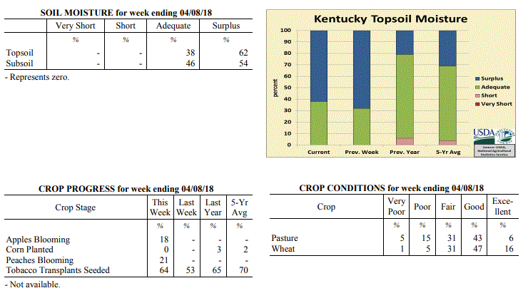 Kentucky Climate Summary
For the Period April 2 to April 8, 2018
Well Below Normal Temperatures and Above Normal Precipitation:
Weather-wise, Kentucky went through a rollercoaster this past week, seeing glimpses
of both winter and spring. Early in the week, focus was on severe weather. With the
state located within an unstable air mass, strong to severe storms formed ahead and
along a strong cold Tuesday evening and into the overnight. Several tornadoes were
confirmed across Western and Central Kentucky, in addition to damaging winds. Ahead
of the boundary, temperatures soared into the 70s, but then took quite the step back
with the frontal passage and Canadian high pressure building into the Ohio Valley.
Thursday morning lows dipped into the middle 20s to low 30s, prompting the first
freeze warnings of the spring season to be issued as some agriculture becomes
susceptible. While mild on Friday, another cold front pushed through the area Friday
night. Precipitation transitioned to a wet snow and led to some minor accumulations
with most under an inch. Skies cleared Saturday night and another freeze warning was
issued with lows dipping again into the 20s. Even had several locations in the upper
teens to low 20s.
Temperatures for the period averaged 44 degrees across the state which was 8 degrees
cooler than normal and 10 degrees cooler than the previous period. High temperatures
averaged from 54 in the West to 56 in the East. Departure from normal high
temperatures ranged from 12 degrees cooler than normal in the West to 9 degrees
cooler than normal in the East. Low temperatures averaged from 36 degrees in the
West to 34 degrees in the East. Departure from normal low temperature ranged from 7
degrees cooler than normal in the West to 3 degrees cooler than normal in the East.
The extreme high temperature for the period was 80 degrees at FORT CAMPBELL and the
extreme low was 19 degrees at RICHMOND 8E.
Precipitation (liq. equ.) for the period totaled 1.34 inches statewide which was 0.35
inches above normal and 136% of normal. Precipitation totals by climate division,
West 0.80 inches, Central 1.21 inches, Bluegrass 1.57 inches and East 1.80 inches,
which was -0.29, 0.19, 0.67 and 0.86 inches respectively from normal. By station,
precipitation totals ranged from a low of 0.41 inches at CAPE GIRARDEAU ASOS to a
high of 3.46 inches at JACKSON AIRPORT.
---
Kentucky Crop and Weather Report
Issued 4:00 P.M., April 2, 2018 05-18
Agricultural News: Kentucky experienced above normal temperatures and precipitation
over the past week. Precipitation for the week totaled 1.95 inches, 0.93 inches above
normal. Temperatures averaged 54 degrees for the week, 4 degrees above normal.
Topsoil moisture was rated 32 percent adequate and 68 percent surplus. Subsoil
moisture was rated 40 percent adequate and 60 percent surplus. Days suitable for
fieldwork averaged 1 out of a possible seven.
Primary activity for this week was seeding of tobacco transplants. Persistent
rainfall and cool temperatures statewide have kept farmers from working the fields in
preparation for spring planting. The ground is saturated in many areas with some
ponding reported in low lying fields. There was very little freeze damage reported
for winter wheat and the crop is in mostly good condition at this time. Freeze damage
to Alfalfa was not prevalent in the state and was reported as light where it existed.
Livestock operations are looking ahead to spring calving and monitoring the condition
of their herds. The condition of livestock was rated as 1 percent very poor, 4
percent poor, 20 percent fair, 68 percent good, and 7 percent excellent.
Approximately 30 percent of feed for cattle and calves was obtained from pastures.
The condition of pastures was reported as 6 percent very poor, 13 percent poor, 31
percent fair, 46 percent good, and 4 percent excellent. The muddy conditions and
temperature swings have had an effect on cattle according to some producers. Hay
supplies are getting short for some farmers as they await spring rejuvenation of
pastures. The extremely wet conditions have caused a good deal of damage to some grazing
land due to livestock traffic.
Kentucky Climate Summary
For the Period April 2 to April 8, 2018
Well Below Normal Temperatures and Above Normal Precipitation:
Weather-wise, Kentucky went through a rollercoaster this past week, seeing glimpses
of both winter and spring. Early in the week, focus was on severe weather. With the
state located within an unstable air mass, strong to severe storms formed ahead and
along a strong cold Tuesday evening and into the overnight. Several tornadoes were
confirmed across Western and Central Kentucky, in addition to damaging winds. Ahead
of the boundary, temperatures soared into the 70s, but then took quite the step back
with the frontal passage and Canadian high pressure building into the Ohio Valley.
Thursday morning lows dipped into the middle 20s to low 30s, prompting the first
freeze warnings of the spring season to be issued as some agriculture becomes
susceptible. While mild on Friday, another cold front pushed through the area Friday
night. Precipitation transitioned to a wet snow and led to some minor accumulations
with most under an inch. Skies cleared Saturday night and another freeze warning was
issued with lows dipping again into the 20s. Even had several locations in the upper
teens to low 20s.
Temperatures for the period averaged 44 degrees across the state which was 8 degrees
cooler than normal and 10 degrees cooler than the previous period. High temperatures
averaged from 54 in the West to 56 in the East. Departure from normal high
temperatures ranged from 12 degrees cooler than normal in the West to 9 degrees
cooler than normal in the East. Low temperatures averaged from 36 degrees in the
West to 34 degrees in the East. Departure from normal low temperature ranged from 7
degrees cooler than normal in the West to 3 degrees cooler than normal in the East.
The extreme high temperature for the period was 80 degrees at FORT CAMPBELL and the
extreme low was 19 degrees at RICHMOND 8E.
Precipitation (liq. equ.) for the period totaled 1.34 inches statewide which was 0.35
inches above normal and 136% of normal. Precipitation totals by climate division,
West 0.80 inches, Central 1.21 inches, Bluegrass 1.57 inches and East 1.80 inches,
which was -0.29, 0.19, 0.67 and 0.86 inches respectively from normal. By station,
precipitation totals ranged from a low of 0.41 inches at CAPE GIRARDEAU ASOS to a
high of 3.46 inches at JACKSON AIRPORT.
---
Kentucky Crop and Weather Report
Issued 4:00 P.M., April 2, 2018 05-18
Agricultural News: Kentucky experienced above normal temperatures and precipitation
over the past week. Precipitation for the week totaled 1.95 inches, 0.93 inches above
normal. Temperatures averaged 54 degrees for the week, 4 degrees above normal.
Topsoil moisture was rated 32 percent adequate and 68 percent surplus. Subsoil
moisture was rated 40 percent adequate and 60 percent surplus. Days suitable for
fieldwork averaged 1 out of a possible seven.
Primary activity for this week was seeding of tobacco transplants. Persistent
rainfall and cool temperatures statewide have kept farmers from working the fields in
preparation for spring planting. The ground is saturated in many areas with some
ponding reported in low lying fields. There was very little freeze damage reported
for winter wheat and the crop is in mostly good condition at this time. Freeze damage
to Alfalfa was not prevalent in the state and was reported as light where it existed.
Livestock operations are looking ahead to spring calving and monitoring the condition
of their herds. The condition of livestock was rated as 1 percent very poor, 4
percent poor, 20 percent fair, 68 percent good, and 7 percent excellent.
Approximately 30 percent of feed for cattle and calves was obtained from pastures.
The condition of pastures was reported as 6 percent very poor, 13 percent poor, 31
percent fair, 46 percent good, and 4 percent excellent. The muddy conditions and
temperature swings have had an effect on cattle according to some producers. Hay
supplies are getting short for some farmers as they await spring rejuvenation of
pastures. The extremely wet conditions have caused a good deal of damage to some grazing
land due to livestock traffic.
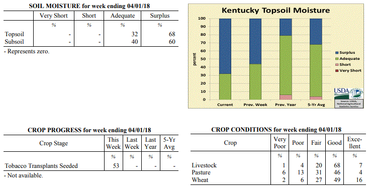 Kentucky Climate Summary
For the Period March 26 to April 1, 2018
Above Normal Temperatures and Precipitation:
As the growing season comes to a start, Kentucky grounds are saturated behind
excessively wet conditions over the last week of March. From Tuesday through Friday,
a frontal boundary remained in the vicinity of Kentucky and was the focus for
multiple rounds of rainfall as disturbances passed overhead. A deep plume of
moisture from the Gulf led to a very moist atmosphere and moderate to heavy rainfall
from time to time. While the main show came over the course of the workweek, a
couple more rounds arrived over the weekend. Overall, Kentucky averaged nearly two
inches for the week, which led to a second straight week of above normal
precipitation for Kentucky. Temperature-wise, highs jumped into the 50s and 60s on a
daily basis. Even hit the 70s in some spots. This period marked the first time that
Kentucky temperatures had averaged above normal since the first week of March.
Temperatures for the period averaged 54 degrees across the state which was 4 degrees
warmer than normal and 14 degrees warmer than the previous period. High temperatures
averaged from 61 in the West to 63 in the East. Departure from normal high
temperatures ranged from 3 degrees cooler than normal in the West to 1 degree
warmer than normal in the East. Low temperatures averaged from 46 degrees in the
West to 46 degrees in the East. Departure from normal low temperature ranged from 6
degrees warmer than normal in the West to 10 degrees warmer than normal in the
East. The extreme high temperature for the period was 78 degrees at WHITESBURG 2NW
and the extreme low was 29 degrees at BRANDENBURG 4SW.
Precipitation (liq. equ.) for the period totaled 1.95 inches statewide which was 0.93
inches above normal and 191% of normal. Precipitation totals by climate division,
West 2.39 inches, Central 2.19 inches, Bluegrass 1.75 inches and East 1.47 inches,
which was 1.29, 1.11, 0.83 and 0.48 inches above normal. By station, precipitation
totals ranged from a low of 0.29 inches at YELLOW CREEK to a high of 4.23
inches at CARBONDALE ASOS.
---
Kentucky Climate Summary
For the Period March 19 to March 25, 2018
Well Below Normal Temperatures and Above Normal Precipitation:
The calendar said spring arrived on Tuesday, but it seemed to be nowhere in sight.
For a third consecutive week, temperatures averaged below normal. Cold enough that
Kentucky saw a couple more rounds of wintry weather, one on Tuesday/Tuesday night and
another on Friday night/Saturday. The first event brought 5 to 10 inches of snow to
portions of North Central Kentucky. 1 to 3 for other sections. Snow diminished on
Wednesday, but with a combination of snow cover, mostly cloudy skies, and northwest
flow, temperatures struggled to rise much. Clouds cleared that night with much of
the state in the low to middle 20s and some in the upper teens. While it was dry on
Thursday and Friday, another disturbance crossed the area on Friday night and into
Saturday. Accumulating snow fell in the Bluegrass Region, but eventually
transitioned to rain. This event pushed precipitation above normal for the week,
marking the first time that had happened since late February.
Temperatures for the period averaged 41 degrees across the state which was 7 degrees
cooler than normal and 2 degrees cooler than the previous period. High temperatures
averaged from 53 in the West to 49 in the East. Departure from normal high
temperatures ranged from 8 degrees cooler than normal in the West to 12 degrees
cooler than normal in the East. Low temperatures averaged from 37 degrees in the
West to 31 degrees in the East. Departure from normal low temperature ranged from 2
degrees cooler than normal in the West to 3 degrees cooler than normal in the East.
The extreme high temperature for the period was 76 degrees at POPLAR BLUFF ASOS and
the extreme low was 16 degrees at CYNTHIANA 8N.
Precipitation (liq. equ.) for the period totaled 1.64 inches statewide which was 0.6
inches above normal and 158% of normal. Precipitation totals by climate division,
West 1.16 inches, Central 1.92 inches, Bluegrass 1.65 inches and East 1.84 inches,
which was 0.05, 0.82, 0.71 and 0.83 inches above normal. By station, precipitation
totals ranged from a low of 0.43 inches at FORT CAMPBELL to a high of 3.06 inches at
SHEPHERDSVILLE 6SE.
---
Kentucky Climate Summary
For the Period March 12 to March 18, 2018
Below Normal Temperatures and Precipitation:
Even with spring right around the corner, Old Man Winter is making his presence
known. The week started with a major winter storm in progress. A large portion of
the state’s midsection received in upwards of 4 inches. The highest accumulations
were saw around Lexington, Danville, and Richmond with 8 to 10 inches in spots.
Unlike the snow events of 2015, Kentucky did not have Arctic air in place. In fact,
temperatures rose above freezing into the upper 30s to low 40s on Monday. Saying
that, the heavy/wet nature of the snow caused some trees to fall and
corresponding power outages. Temperatures more typical of January continued through
Wednesday with another round of wintry weather on Tuesday night. After a warm up to
end the work week, more showers and even storms arrived for the first half of the
weekend. Overall, the state averaged just over a half inch for the week, marking the
third straight week of below normal precipitation for the state.
Temperatures for the period averaged 42 degrees across the state which was 4 degrees
cooler than normal and no change to the previous period. High temperatures averaged
from 55 in the West to 52 in the East. Departure from normal high temperatures
ranged from 4 degrees cooler than normal in the West to 6 degrees cooler than normal
in the East. Low temperatures averaged from 36 degrees in the West to 31 degrees in
the East. Departure from normal low temperature ranged from 1 degree cooler than
normal in the West to 1 degree cooler than normal in the East. The extreme high
temperature for the period was 78 degrees at BARBOURVILLE 3E and the extreme low was
17 degrees at HARRODSBURG 3N.
Precipitation (liq. equ.) for the period totaled 0.57 inches statewide which was 0.43
inches below normal and 57% of normal. Precipitation totals by climate division, West
0.49 inches, Central 0.57 inches, Bluegrass 0.51 inches and East 0.73 inches, which
was 0.56, 0.48, 0.4 and 0.26 inches below normal. By station, precipitation totals
ranged from a low of 0.16 inches at BURLINGTON 4S to a high of 1.47 inches at WHITLEY
CITY 3N.
---
Kentucky Climate Summary
For the Period March 5 to March 11, 2018
Below Normal Temperatures and Precipitation:
After a warm end to February and start to March, winter weather has made a return.
Temperatures were warm early in the week, topping out in the upper 50s to low 60s on
Tuesday, but a cold front moved through the area that night. Cloudy and cool
conditions were seen on Wednesday, before temperatures took quite the plunge. Lows
both Thursday and Friday mornings dipped into the 20s. This set the stage for
snowfall to return. While the state did see some light rounds during the latter half
of the workweek, more significant activity arrived for the weekend. The first round
on Friday night brought a slushy one-inch of accumulation to the Bluegrass, in
addition to portions of Central and Eastern Kentucky. This snow melted rather quickly
with warm temperatures on Saturday, but a major winter storm then started to progress
across the area later in the day on Sunday. Most of the precipitation from this
system fell after the cutoff time for this period and will be addressed in the next
weekly summary.
Temperatures for the period averaged 41 degrees across the state which was 4 degrees
cooler than normal and 6 degrees cooler than the previous period. High temperatures
averaged from 51 in the West to 50 in the East. Departure from normal high
temperatures ranged from 6 degrees cooler than normal in the West to 7 degrees
cooler than normal in the East. Low temperatures averaged from 34 degrees in the
West to 32 degrees in the East. Departure from normal low temperature ranged from 1
degree cooler than normal in the West to 1 degree warmer than normal in the East.
The extreme high temperature for the period was 64 degrees at BOONEVILLE 2S and the
extreme low was 15 degrees at MONTICELLO AWOS.
Precipitation (liq. equ.) for the period totaled 0.47 inches statewide which was 0.51
inches below normal and 48% of normal. Precipitation totals by climate division, West
0.69 inches, Central 0.50 inches, Bluegrass 0.39 inches and East 0.30 inches, which
was 0.34, 0.53, 0.5 and 0.66 inches below normal. By station, precipitation totals
ranged from a low of 0.03 inches at ALEXANDRIA 5NW to a high of 1.66 inches at CAPE
GIRARDEAU ASOS.
---
Kentucky Climate Summary
For the Period February 26 to March 4, 2018
Above Normal Temperatures and Below Normal Precipitation:
Kentucky needed to see some drier conditions after getting drenched in February.
While not completely dry, the state did see below normal precipitation for the
period, breaking a three week streak of well above normal rainfall. The state
averaged about a half inch over the course of Tuesday night through Thursday, ending
with the passage of a cold front. The rest of the period remained dry and seasonably
warm with high pressure in place.
Temperatures for the period averaged 47 degrees across the state which was 4 degrees
warmer than normal and 12 degrees cooler than the previous period. High temperatures
averaged from 58 in the West to 55 in the East. Departure from normal high
temperatures ranged from 3 degrees warmer than normal in the West to near normal in
the East. Low temperatures averaged from 39 degrees in the West to 37 degrees in the
East. Departure from normal low temperature ranged from 5 degrees warmer than normal
in the West to 7 degrees warmer than normal in the East. The extreme high temperature
for the period was 68 degrees at BENTON 4N and the extreme low was 21 degrees at BOONEVILLE 2S.
Precipitation (liq. equ.) for the period totaled 0.53 inches statewide which was 0.45
inches below normal and 54% of normal. Precipitation totals by climate division, West
0.59 inches, Central 0.50 inches, Bluegrass 0.33 inches and East 0.71 inches, which
was 0.5, 0.53, 0.53 and 0.22 inches below normal. By station, precipitation totals
ranged from a low of 0.06 inches at OWENSBORO AWSS to a high of 1.29 inches at WHITLEY CITY 3N.
---
Kentucky Climate Summary
For the Period February 19 to February 25, 2018
Well Above Normal Temperatures and Precipitation:
Flooding became a real problem over the course of the week as the state averaged
almost four inches on top of already saturated grounds, which is nearly three inches
above normal. The prolonged and widespread nature of this event made it unique.
Widespread rains fell on a daily basis from Wednesday through the latter half of the
weekend, ending with the passage of a strong to severe line of storms Saturday night.
Many locations from Western Kentucky and up into the Bluegrass recorded more than 6
inches. This pushed many area rivers into minor/moderate flood stages. While the
high rainfall totals were the big issue, the state did get to enjoy some very warm
weather for late February, especially early in the workweek. High temperatures jumped
into the upper 70s to low 80s on Tuesday behind breezy southwest flow. Some locations
broke all-time record highs for the month of February.
Temperatures for the period averaged 60 degrees across the state which was 20 degrees
warmer than normal and 14 degrees warmer than the previous period. High temperatures
averaged from 66 in the West to 72 in the East. Departure from normal high
temperatures ranged from 14 degrees warmer than normal in the West to 20 degrees
warmer than normal in the East. Low temperatures averaged from 49 degrees in the
West to 54 degrees in the East. Departure from normal low temperature ranged from 18
degrees warmer than normal in the West to 27 degrees warmer than normal in the
East. The extreme high temperature for the period was 82 degrees at BOONEVILLE 2S and
the extreme low was 34 degrees at CAPE GIRARDEAU ASOS.
Precipitation (liq. equ.) for the period totaled 3.76 inches statewide which was 2.8
inches above normal and 394% of normal. Precipitation totals by climate division,
West 5.48 inches, Central 4.15 inches, Bluegrass 3.78 inches and East 1.62 inches,
which was 4.4, 3.12, 2.96 and 0.73 inches above normal. By station, precipitation
totals ranged from a low of 0.73 inches at BIG SANDY to a high of 7.48 inches at
CAPE GIRARDEAU ASOS.
---
Kentucky Climate Summary
For the Period February 12 to February 18, 2018
Well Above Normal Temperatures and Precipitation:
Soils have become saturated across the majority of Kentucky with multiple rounds of
passing rainfall. Kentucky averaged over 1.5 inches this period, marking the
second straight week the state has exceeded that mark. While the week started with
a wintry mix in place, temperatures quickly jumped by Tuesday and continued that
trend through Thursday, ahead of a cold front. Most everyone in the state eventually
got into the low to middle 70s. The warm temperatures were accompanied by abundant
moisture being funneled into the region from the Gulf of Mexico. This led to
moderate to heavy rain at times, pushing rivers and streams to start running high and
prompting many river flood warnings to be issued. The two week state average now
sits at 4.03 inches, which is over 2.25 inches above normal. To put that in
perspective, average February rainfall for Kentucky is 3.68.
Temperatures for the period averaged 47 degrees across the state which was 10 degrees
warmer than normal and 10 degrees warmer than the previous period. High temperatures
averaged from 56 in the West to 56 in the East. Departure from normal high
temperatures ranged from 7 degrees warmer than normal in the West to 7 degrees
warmer than normal in the East. Low temperatures averaged from 38 degrees in the
West to 40 degrees in the East. Departure from normal low temperature ranged from 9
degrees warmer than normal in the West to 15 degrees warmer than normal in the
East. The extreme high temperature for the period was 77 degrees at BOONEVILLE 2S and
the extreme low was 19 degrees at CAPE GIRARDEAU ASOS.
Precipitation (liq. equ.) for the period totaled 1.71 inches statewide which was 0.81
inches above normal and 189% of normal. Precipitation totals by climate division,
West 1.27 inches, Central 1.55 inches, Bluegrass 2.02 inches and East 2.00 inches,
which was 0.26, 0.57, 1.24 and 1.16 inches above normal. By station, precipitation
totals ranged from a low of 0.92 inches at FORT CAMPBELL to a high of 3.06 inches at
WHITLEY CITY 3N.
---
Kentucky Climate Summary
For the Period February 5 to February 11, 2018
Near Normal Temperatures and Well Above Normal Precipitation:
A very active period led to extremely high precipitation totals across the area. The
first half of the week saw a continuation of winter weather. The most significant
came Tuesday night and into Wednesday morning as low pressure moved northeast through
the area. Precipitation fell as freezing rain on the north side of the system,
resulting in impactful ice accumulations along the Ohio River around a tenth to
quarter inch. Elsewhere to the south, most precipitation fell as rain with
accumulations of 1 to 2 inches. Dry conditions prevailed for the end of the
workweek, but a very slow moving frontal boundary led to a wet weekend. An
additional two to three inches fell across South-Central and Southeastern Kentucky
with a very moist atmosphere in place. This led to many flood warnings and advisories
across the area. Overall, the state averaged over two inches of liquid precipitation
at 2.32, the most in one week since the end of August and start of September last year.
Temperatures for the period averaged 36 degrees across the state which was near
normal and 4 degrees warmer than the previous period. High temperatures
averaged from 42 in the West to 48 in the East. Departure from normal high
temperatures ranged from 5 degrees cooler than normal in the West to 1 degree
warmer than normal in the East. Low temperatures averaged from 27 degrees in the
West to 31 degrees in the East. Departure from normal low temperature ranged from
near normal in the West to 7 degrees warmer than normal in the East. The
extreme high temperature for the period was 68 degrees at WHITESBURG 2NW and the
extreme low was 5 degrees at CARBONDALE ASOS.
Precipitation (liq. equ.) for the period totaled 2.32 inches statewide which was 1.44
inches above normal and 264% of normal. Precipitation totals by climate division,
West 1.26 inches, Central 2.71 inches, Bluegrass 1.84 inches and East 3.46 inches,
which was 0.29, 1.75, 1.08 and 2.63 inches above normal. By station, precipitation
totals ranged from a low of 0.23 inches at CAPE GIRARDEAU ASOS to a high of 5.42
inches at BARBOURVILLE 3E.
---
Kentucky Climate Summary
For the Period January 29 to February 4, 2018
Below Normal Temperatures and Precipitation:
Throughout the period, the Bluegrass State saw several rounds of wintry weather,
starting the forecast of Punxsutawney Phil on a good note that there will be six more
weeks of winter. Regarding accumulations, all tended to stay on the light side.
Most staying under an inch of snow with each passing round. This kept precipitation
below normal for the week. Even with statewide precipitation below normal by an inch
for the year, the US Drought Monitor only shows abnormally dry conditions showing up
in Southeastern Kentucky as of the latest update. Temperatures were up and down throughout
the week, ending the period only slightly below normal.
Temperatures for the period averaged 33 degrees across the state which was 1 degree
cooler than normal and 12 degrees cooler than the previous period. High temperatures
averaged from 42 in the West to 42 in the East. Departure from normal high
temperatures ranged from 3 degrees cooler than normal in the West to 3 degrees
cooler than normal in the East. Low temperatures averaged from 25 degrees in the
West to 24 degrees in the East. Departure from normal low temperature ranged from 1
degree cooler than normal in the West to 2 degrees warmer than normal in the East.
The extreme high temperature for the period was 61 degrees at HICKMAN 2E and the
extreme low was 6 degrees at CALHOUN 5NW.
Precipitation (liq. equ.) for the period totaled 0.57 inches statewide which was 0.28
inches below normal and 67% of normal. Precipitation totals by climate division, West
0.41 inches, Central 0.57 inches, Bluegrass 0.32 inches and East 0.99 inches, which
was -0.51, -0.35, -0.41 and 0.17 inches respectively from normal. By station,
precipitation totals ranged from a low of 0.06 inches at CARBONDALE ASOS to a high of
1.60 inches at PIKEVILLE AWOS.
---
Kentucky Climate Summary
For the Period January 22 to January 28, 2018
Well Above Normal Temperatures and Above Normal Precipitation:
Kentucky enjoyed a rather warm week relative to where the state has been. Other than
a short-lived cold spell midweek, much of the area saw highs jump into the 50s for
the remainder of the period. After not seeing much precipitation the week before,
Kentucky had a couple systems pass through the region throughout the period, one
coming on Monday and the other on Saturday. Both brought a round of widespread
rainfall. The Saturday event ended up being the more significant as a band of
showers made slow progress across the state. Most of the Commonwealth saw between a
half to one inch of accumulation. With that said, the Monday event did bring
something that has not been seen in a while, a round of scattered thunderstorms that
did lead to gusts around 50 mph for some locations.
Temperatures for the period averaged 46 degrees across the state which was 13 degrees
warmer than normal and 18 degrees warmer than the previous period. High temperatures
averaged from 54 in the West to 53 in the East. Departure from normal high
temperatures ranged from 10 degrees warmer than normal in the West to 9 degrees
warmer than normal in the East. Low temperatures averaged from 39 degrees in the
West to 37 degrees in the East. Departure from normal low temperature ranged from 14
degrees warmer than normal in the West to 15 degrees warmer than normal in the
East. The extreme high temperature for the period was 68 degrees at LOUISA 1S and the
extreme low was 14 degrees at MONTICELLO AWOS.
Precipitation (liq. equ.) for the period totaled 0.89 inches statewide which was 0.1
inches above normal and 113% of normal. Precipitation totals by climate division,
West 1.05 inches, Central 0.95 inches, Bluegrass 0.83 inches and East 0.72 inches,
which was 0.21, 0.11, 0.14 and -0.07 inches respectively from normal. By station,
precipitation totals ranged from a low of 0.19 inches at MONTICELLO AWOS to a high of
1.47 inches at MUNFORDVILLE 6E.
---
Kentucky Climate Summary
For the Period January 15 to January 21, 2018
Below Normal Temperatures and Precipitation:
A second round of winter storms arrived to start the period. A slow moving band of
light to moderate snow progressed across the area over the course of Monday and
Tuesday. As opposed to the previous system, temperatures were cold enough for a
total snow event. While liquid-equivalent precipitation accumulations were under two
tenths of an inch for the week, it did not take much moisture to produce significant
snowfall totals. Overall, most of the state received at least 2 inches of snowfall,
but a large percentage received in excess of four. Six to eight inches in some
spots, especially Western Kentucky.
Arctic air filtered back into the area with the snowfall. Temperatures dropped back
down into the single digits for a few nights and even well below zero for some. This
was the case Wednesday night when Monticello dropped to -17. Not a typo! Luckily,
the thermometer when on the warming trend through the remainder of the week,
eventually hitting the upper 50s to low 60s on Sunday.
Temperatures for the period averaged 28 degrees across the state which was 5 degrees
cooler than normal and 8 degrees cooler than the previous period. High temperatures
averaged from 35 in the West to 40 in the East. Departure from normal high
temperatures ranged from 8 degrees cooler than normal in the West to 3 degrees
cooler than normal in the East. Low temperatures averaged from 19 degrees in the
West to 17 degrees in the East. Departure from normal low temperature ranged from 6
degrees cooler than normal in the West to 6 degrees cooler than normal in the East.
The extreme high temperature for the period was 67 degrees at BOONEVILLE 2S and the
extreme low was -17 degrees at MONTICELLO AWOS.
Precipitation (liq. equ.) for the period totaled 0.15 inches statewide which was 0.68
inches below normal and 18% of normal. Precipitation totals by climate division, West
0.15 inches, Central 0.15 inches, Bluegrass 0.17 inches and East 0.15 inches, which
was 0.73, 0.73, 0.55 and 0.71 inches below normal. By station, precipitation totals
ranged from a low of 0.01 inches at FORT CAMPBELL to a high of 0.41 inches at JACKSON
AIRPORT.
---
Kentucky Climate Summary
For the Period January 8 to January 14, 2018
Above Normal Temperatures and Precipitation:
After a deep freeze the week before, Kentucky started to thaw out over the first half
of the period. South/southwest flow became established on Wednesday and Thursday
with highs pushing into the 50s and 60s. With that said, the warmth did not last long
as another Arctic front pushed through the Ohio Valley Thursday night and into
Friday. Widespread precipitation progressed across the region during this period and
with temperatures dropping, Kentucky saw the first significant winter storm of the
season. Most everyone saw a period of a wintry mix before changing to all snow, some
longer than others. Ice accumulations were highest across the western half of
Kentucky with a quarter inch in some spots. Snow accumulations across the state
ranged from as little as 1 inch to 6+ inches south of Paducah. Snow tapered off on
Saturday, but the cold remained. A fresh snowpack on Saturday night took many areas
back down to around zero for lows.
Temperatures for the period averaged 37 degrees across the state which was 4 degrees
warmer than normal and 22 degrees warmer than the previous period. High temperatures
averaged from 42 in the West to 47 in the East. Departure from normal high
temperatures ranged from 1 degree cooler than normal in the West to 3 degrees
warmer than normal in the East. Low temperatures averaged from 30 degrees in the
West to 30 degrees in the East. Departure from normal low temperature ranged from 4
degrees warmer than normal in the West to 6 degrees warmer than normal in the
East. The extreme high temperature for the period was 74 degrees at LOUISA 1S and
the extreme low was -10 degrees at VANCEBURG 6W.
Precipitation (liq. equ.) for the period totaled 1.27 inches statewide which was 0.4
inches below normal and 145% of normal. Precipitation totals by climate division, West
2.09 inches, Central 1.04 inches, Bluegrass 1.06 inches and East 0.89 inches, which
was 1.17, 0.11, 0.31 and -0.01 inches respectively from normal. By station, precipitation
totals ranged from a low of 0.12 inches at MONTICELLO AWOS to a high of 3.67 inches at
CINCINNATI.
---
Kentucky Climate Summary
For the Period January 1 to January 7, 2018
Well Below Normal Temperatures and Precipitation:
The New Year started with extremely cold conditions in place and that may very well
be an understatement. For the week, low temperatures averaged in the single digits,
which is roughly 20 degrees below normal. Low temperatures on the morning of the 2nd
even dipped below zero for much of Kentucky, marking the first time this had happened
since late winter of 2015. Wind chills consistently dropped below zero, prompting
Wind Chill Advisory’s to be issued at times. This continued the extended period of
livestock cold stress conditions in the emergency category. As Arctic high pressure
finally shifted east late in the weekend, the state did see some southerly flow that
actually sent temperatures above the freezing mark. For much of Kentucky, this was
the first time it happened since December 23rd. Every now and then, the state would
see some isolated to scattered flurries and snow showers, but nothing that really
amounted to much in the way of accumulation. With that said, most of Kentucky did
not see any precipitation for the week, marking a second straight week of similar
conditions.
Temperatures for the period averaged 15 degrees across the state which was 18 degrees
cooler than normal and 6 degrees cooler than the previous period. High temperatures
averaged from 26 in the West to 26 in the East. Departure from normal high
temperatures ranged from 17 degrees cooler than normal in the West to 18 degrees
cooler than normal in the East. Low temperatures averaged from 6 degrees in the
West to 5 degrees in the East. Departure from normal low temperature ranged from 20
degrees cooler than normal in the West to 19 degrees cooler than normal in the
East. The extreme high temperature for the period was 46 degrees at HARTFORD 3E and
the extreme low was -9 degrees at ALEXANDRIA 5NW.
Precipitation (liq. equ.) for the period totaled 0.00 inches statewide which was 0.89
inches below normal and 0% of normal. Precipitation totals by climate division, West
0.01 inches, Central 0.00 inches, Bluegrass 0.00 inches and East 0.00 inches, which
was 0.92, 0.96, 0.76 and 0.9 inches below normal. By station, precipitation totals
ranged from a low of 0.00 inches at ALBANY 1N to a high of 0.07 inches at
CAPE GIRARDEAU ASOS.
Kentucky Climate Summary
For the Period March 26 to April 1, 2018
Above Normal Temperatures and Precipitation:
As the growing season comes to a start, Kentucky grounds are saturated behind
excessively wet conditions over the last week of March. From Tuesday through Friday,
a frontal boundary remained in the vicinity of Kentucky and was the focus for
multiple rounds of rainfall as disturbances passed overhead. A deep plume of
moisture from the Gulf led to a very moist atmosphere and moderate to heavy rainfall
from time to time. While the main show came over the course of the workweek, a
couple more rounds arrived over the weekend. Overall, Kentucky averaged nearly two
inches for the week, which led to a second straight week of above normal
precipitation for Kentucky. Temperature-wise, highs jumped into the 50s and 60s on a
daily basis. Even hit the 70s in some spots. This period marked the first time that
Kentucky temperatures had averaged above normal since the first week of March.
Temperatures for the period averaged 54 degrees across the state which was 4 degrees
warmer than normal and 14 degrees warmer than the previous period. High temperatures
averaged from 61 in the West to 63 in the East. Departure from normal high
temperatures ranged from 3 degrees cooler than normal in the West to 1 degree
warmer than normal in the East. Low temperatures averaged from 46 degrees in the
West to 46 degrees in the East. Departure from normal low temperature ranged from 6
degrees warmer than normal in the West to 10 degrees warmer than normal in the
East. The extreme high temperature for the period was 78 degrees at WHITESBURG 2NW
and the extreme low was 29 degrees at BRANDENBURG 4SW.
Precipitation (liq. equ.) for the period totaled 1.95 inches statewide which was 0.93
inches above normal and 191% of normal. Precipitation totals by climate division,
West 2.39 inches, Central 2.19 inches, Bluegrass 1.75 inches and East 1.47 inches,
which was 1.29, 1.11, 0.83 and 0.48 inches above normal. By station, precipitation
totals ranged from a low of 0.29 inches at YELLOW CREEK to a high of 4.23
inches at CARBONDALE ASOS.
---
Kentucky Climate Summary
For the Period March 19 to March 25, 2018
Well Below Normal Temperatures and Above Normal Precipitation:
The calendar said spring arrived on Tuesday, but it seemed to be nowhere in sight.
For a third consecutive week, temperatures averaged below normal. Cold enough that
Kentucky saw a couple more rounds of wintry weather, one on Tuesday/Tuesday night and
another on Friday night/Saturday. The first event brought 5 to 10 inches of snow to
portions of North Central Kentucky. 1 to 3 for other sections. Snow diminished on
Wednesday, but with a combination of snow cover, mostly cloudy skies, and northwest
flow, temperatures struggled to rise much. Clouds cleared that night with much of
the state in the low to middle 20s and some in the upper teens. While it was dry on
Thursday and Friday, another disturbance crossed the area on Friday night and into
Saturday. Accumulating snow fell in the Bluegrass Region, but eventually
transitioned to rain. This event pushed precipitation above normal for the week,
marking the first time that had happened since late February.
Temperatures for the period averaged 41 degrees across the state which was 7 degrees
cooler than normal and 2 degrees cooler than the previous period. High temperatures
averaged from 53 in the West to 49 in the East. Departure from normal high
temperatures ranged from 8 degrees cooler than normal in the West to 12 degrees
cooler than normal in the East. Low temperatures averaged from 37 degrees in the
West to 31 degrees in the East. Departure from normal low temperature ranged from 2
degrees cooler than normal in the West to 3 degrees cooler than normal in the East.
The extreme high temperature for the period was 76 degrees at POPLAR BLUFF ASOS and
the extreme low was 16 degrees at CYNTHIANA 8N.
Precipitation (liq. equ.) for the period totaled 1.64 inches statewide which was 0.6
inches above normal and 158% of normal. Precipitation totals by climate division,
West 1.16 inches, Central 1.92 inches, Bluegrass 1.65 inches and East 1.84 inches,
which was 0.05, 0.82, 0.71 and 0.83 inches above normal. By station, precipitation
totals ranged from a low of 0.43 inches at FORT CAMPBELL to a high of 3.06 inches at
SHEPHERDSVILLE 6SE.
---
Kentucky Climate Summary
For the Period March 12 to March 18, 2018
Below Normal Temperatures and Precipitation:
Even with spring right around the corner, Old Man Winter is making his presence
known. The week started with a major winter storm in progress. A large portion of
the state’s midsection received in upwards of 4 inches. The highest accumulations
were saw around Lexington, Danville, and Richmond with 8 to 10 inches in spots.
Unlike the snow events of 2015, Kentucky did not have Arctic air in place. In fact,
temperatures rose above freezing into the upper 30s to low 40s on Monday. Saying
that, the heavy/wet nature of the snow caused some trees to fall and
corresponding power outages. Temperatures more typical of January continued through
Wednesday with another round of wintry weather on Tuesday night. After a warm up to
end the work week, more showers and even storms arrived for the first half of the
weekend. Overall, the state averaged just over a half inch for the week, marking the
third straight week of below normal precipitation for the state.
Temperatures for the period averaged 42 degrees across the state which was 4 degrees
cooler than normal and no change to the previous period. High temperatures averaged
from 55 in the West to 52 in the East. Departure from normal high temperatures
ranged from 4 degrees cooler than normal in the West to 6 degrees cooler than normal
in the East. Low temperatures averaged from 36 degrees in the West to 31 degrees in
the East. Departure from normal low temperature ranged from 1 degree cooler than
normal in the West to 1 degree cooler than normal in the East. The extreme high
temperature for the period was 78 degrees at BARBOURVILLE 3E and the extreme low was
17 degrees at HARRODSBURG 3N.
Precipitation (liq. equ.) for the period totaled 0.57 inches statewide which was 0.43
inches below normal and 57% of normal. Precipitation totals by climate division, West
0.49 inches, Central 0.57 inches, Bluegrass 0.51 inches and East 0.73 inches, which
was 0.56, 0.48, 0.4 and 0.26 inches below normal. By station, precipitation totals
ranged from a low of 0.16 inches at BURLINGTON 4S to a high of 1.47 inches at WHITLEY
CITY 3N.
---
Kentucky Climate Summary
For the Period March 5 to March 11, 2018
Below Normal Temperatures and Precipitation:
After a warm end to February and start to March, winter weather has made a return.
Temperatures were warm early in the week, topping out in the upper 50s to low 60s on
Tuesday, but a cold front moved through the area that night. Cloudy and cool
conditions were seen on Wednesday, before temperatures took quite the plunge. Lows
both Thursday and Friday mornings dipped into the 20s. This set the stage for
snowfall to return. While the state did see some light rounds during the latter half
of the workweek, more significant activity arrived for the weekend. The first round
on Friday night brought a slushy one-inch of accumulation to the Bluegrass, in
addition to portions of Central and Eastern Kentucky. This snow melted rather quickly
with warm temperatures on Saturday, but a major winter storm then started to progress
across the area later in the day on Sunday. Most of the precipitation from this
system fell after the cutoff time for this period and will be addressed in the next
weekly summary.
Temperatures for the period averaged 41 degrees across the state which was 4 degrees
cooler than normal and 6 degrees cooler than the previous period. High temperatures
averaged from 51 in the West to 50 in the East. Departure from normal high
temperatures ranged from 6 degrees cooler than normal in the West to 7 degrees
cooler than normal in the East. Low temperatures averaged from 34 degrees in the
West to 32 degrees in the East. Departure from normal low temperature ranged from 1
degree cooler than normal in the West to 1 degree warmer than normal in the East.
The extreme high temperature for the period was 64 degrees at BOONEVILLE 2S and the
extreme low was 15 degrees at MONTICELLO AWOS.
Precipitation (liq. equ.) for the period totaled 0.47 inches statewide which was 0.51
inches below normal and 48% of normal. Precipitation totals by climate division, West
0.69 inches, Central 0.50 inches, Bluegrass 0.39 inches and East 0.30 inches, which
was 0.34, 0.53, 0.5 and 0.66 inches below normal. By station, precipitation totals
ranged from a low of 0.03 inches at ALEXANDRIA 5NW to a high of 1.66 inches at CAPE
GIRARDEAU ASOS.
---
Kentucky Climate Summary
For the Period February 26 to March 4, 2018
Above Normal Temperatures and Below Normal Precipitation:
Kentucky needed to see some drier conditions after getting drenched in February.
While not completely dry, the state did see below normal precipitation for the
period, breaking a three week streak of well above normal rainfall. The state
averaged about a half inch over the course of Tuesday night through Thursday, ending
with the passage of a cold front. The rest of the period remained dry and seasonably
warm with high pressure in place.
Temperatures for the period averaged 47 degrees across the state which was 4 degrees
warmer than normal and 12 degrees cooler than the previous period. High temperatures
averaged from 58 in the West to 55 in the East. Departure from normal high
temperatures ranged from 3 degrees warmer than normal in the West to near normal in
the East. Low temperatures averaged from 39 degrees in the West to 37 degrees in the
East. Departure from normal low temperature ranged from 5 degrees warmer than normal
in the West to 7 degrees warmer than normal in the East. The extreme high temperature
for the period was 68 degrees at BENTON 4N and the extreme low was 21 degrees at BOONEVILLE 2S.
Precipitation (liq. equ.) for the period totaled 0.53 inches statewide which was 0.45
inches below normal and 54% of normal. Precipitation totals by climate division, West
0.59 inches, Central 0.50 inches, Bluegrass 0.33 inches and East 0.71 inches, which
was 0.5, 0.53, 0.53 and 0.22 inches below normal. By station, precipitation totals
ranged from a low of 0.06 inches at OWENSBORO AWSS to a high of 1.29 inches at WHITLEY CITY 3N.
---
Kentucky Climate Summary
For the Period February 19 to February 25, 2018
Well Above Normal Temperatures and Precipitation:
Flooding became a real problem over the course of the week as the state averaged
almost four inches on top of already saturated grounds, which is nearly three inches
above normal. The prolonged and widespread nature of this event made it unique.
Widespread rains fell on a daily basis from Wednesday through the latter half of the
weekend, ending with the passage of a strong to severe line of storms Saturday night.
Many locations from Western Kentucky and up into the Bluegrass recorded more than 6
inches. This pushed many area rivers into minor/moderate flood stages. While the
high rainfall totals were the big issue, the state did get to enjoy some very warm
weather for late February, especially early in the workweek. High temperatures jumped
into the upper 70s to low 80s on Tuesday behind breezy southwest flow. Some locations
broke all-time record highs for the month of February.
Temperatures for the period averaged 60 degrees across the state which was 20 degrees
warmer than normal and 14 degrees warmer than the previous period. High temperatures
averaged from 66 in the West to 72 in the East. Departure from normal high
temperatures ranged from 14 degrees warmer than normal in the West to 20 degrees
warmer than normal in the East. Low temperatures averaged from 49 degrees in the
West to 54 degrees in the East. Departure from normal low temperature ranged from 18
degrees warmer than normal in the West to 27 degrees warmer than normal in the
East. The extreme high temperature for the period was 82 degrees at BOONEVILLE 2S and
the extreme low was 34 degrees at CAPE GIRARDEAU ASOS.
Precipitation (liq. equ.) for the period totaled 3.76 inches statewide which was 2.8
inches above normal and 394% of normal. Precipitation totals by climate division,
West 5.48 inches, Central 4.15 inches, Bluegrass 3.78 inches and East 1.62 inches,
which was 4.4, 3.12, 2.96 and 0.73 inches above normal. By station, precipitation
totals ranged from a low of 0.73 inches at BIG SANDY to a high of 7.48 inches at
CAPE GIRARDEAU ASOS.
---
Kentucky Climate Summary
For the Period February 12 to February 18, 2018
Well Above Normal Temperatures and Precipitation:
Soils have become saturated across the majority of Kentucky with multiple rounds of
passing rainfall. Kentucky averaged over 1.5 inches this period, marking the
second straight week the state has exceeded that mark. While the week started with
a wintry mix in place, temperatures quickly jumped by Tuesday and continued that
trend through Thursday, ahead of a cold front. Most everyone in the state eventually
got into the low to middle 70s. The warm temperatures were accompanied by abundant
moisture being funneled into the region from the Gulf of Mexico. This led to
moderate to heavy rain at times, pushing rivers and streams to start running high and
prompting many river flood warnings to be issued. The two week state average now
sits at 4.03 inches, which is over 2.25 inches above normal. To put that in
perspective, average February rainfall for Kentucky is 3.68.
Temperatures for the period averaged 47 degrees across the state which was 10 degrees
warmer than normal and 10 degrees warmer than the previous period. High temperatures
averaged from 56 in the West to 56 in the East. Departure from normal high
temperatures ranged from 7 degrees warmer than normal in the West to 7 degrees
warmer than normal in the East. Low temperatures averaged from 38 degrees in the
West to 40 degrees in the East. Departure from normal low temperature ranged from 9
degrees warmer than normal in the West to 15 degrees warmer than normal in the
East. The extreme high temperature for the period was 77 degrees at BOONEVILLE 2S and
the extreme low was 19 degrees at CAPE GIRARDEAU ASOS.
Precipitation (liq. equ.) for the period totaled 1.71 inches statewide which was 0.81
inches above normal and 189% of normal. Precipitation totals by climate division,
West 1.27 inches, Central 1.55 inches, Bluegrass 2.02 inches and East 2.00 inches,
which was 0.26, 0.57, 1.24 and 1.16 inches above normal. By station, precipitation
totals ranged from a low of 0.92 inches at FORT CAMPBELL to a high of 3.06 inches at
WHITLEY CITY 3N.
---
Kentucky Climate Summary
For the Period February 5 to February 11, 2018
Near Normal Temperatures and Well Above Normal Precipitation:
A very active period led to extremely high precipitation totals across the area. The
first half of the week saw a continuation of winter weather. The most significant
came Tuesday night and into Wednesday morning as low pressure moved northeast through
the area. Precipitation fell as freezing rain on the north side of the system,
resulting in impactful ice accumulations along the Ohio River around a tenth to
quarter inch. Elsewhere to the south, most precipitation fell as rain with
accumulations of 1 to 2 inches. Dry conditions prevailed for the end of the
workweek, but a very slow moving frontal boundary led to a wet weekend. An
additional two to three inches fell across South-Central and Southeastern Kentucky
with a very moist atmosphere in place. This led to many flood warnings and advisories
across the area. Overall, the state averaged over two inches of liquid precipitation
at 2.32, the most in one week since the end of August and start of September last year.
Temperatures for the period averaged 36 degrees across the state which was near
normal and 4 degrees warmer than the previous period. High temperatures
averaged from 42 in the West to 48 in the East. Departure from normal high
temperatures ranged from 5 degrees cooler than normal in the West to 1 degree
warmer than normal in the East. Low temperatures averaged from 27 degrees in the
West to 31 degrees in the East. Departure from normal low temperature ranged from
near normal in the West to 7 degrees warmer than normal in the East. The
extreme high temperature for the period was 68 degrees at WHITESBURG 2NW and the
extreme low was 5 degrees at CARBONDALE ASOS.
Precipitation (liq. equ.) for the period totaled 2.32 inches statewide which was 1.44
inches above normal and 264% of normal. Precipitation totals by climate division,
West 1.26 inches, Central 2.71 inches, Bluegrass 1.84 inches and East 3.46 inches,
which was 0.29, 1.75, 1.08 and 2.63 inches above normal. By station, precipitation
totals ranged from a low of 0.23 inches at CAPE GIRARDEAU ASOS to a high of 5.42
inches at BARBOURVILLE 3E.
---
Kentucky Climate Summary
For the Period January 29 to February 4, 2018
Below Normal Temperatures and Precipitation:
Throughout the period, the Bluegrass State saw several rounds of wintry weather,
starting the forecast of Punxsutawney Phil on a good note that there will be six more
weeks of winter. Regarding accumulations, all tended to stay on the light side.
Most staying under an inch of snow with each passing round. This kept precipitation
below normal for the week. Even with statewide precipitation below normal by an inch
for the year, the US Drought Monitor only shows abnormally dry conditions showing up
in Southeastern Kentucky as of the latest update. Temperatures were up and down throughout
the week, ending the period only slightly below normal.
Temperatures for the period averaged 33 degrees across the state which was 1 degree
cooler than normal and 12 degrees cooler than the previous period. High temperatures
averaged from 42 in the West to 42 in the East. Departure from normal high
temperatures ranged from 3 degrees cooler than normal in the West to 3 degrees
cooler than normal in the East. Low temperatures averaged from 25 degrees in the
West to 24 degrees in the East. Departure from normal low temperature ranged from 1
degree cooler than normal in the West to 2 degrees warmer than normal in the East.
The extreme high temperature for the period was 61 degrees at HICKMAN 2E and the
extreme low was 6 degrees at CALHOUN 5NW.
Precipitation (liq. equ.) for the period totaled 0.57 inches statewide which was 0.28
inches below normal and 67% of normal. Precipitation totals by climate division, West
0.41 inches, Central 0.57 inches, Bluegrass 0.32 inches and East 0.99 inches, which
was -0.51, -0.35, -0.41 and 0.17 inches respectively from normal. By station,
precipitation totals ranged from a low of 0.06 inches at CARBONDALE ASOS to a high of
1.60 inches at PIKEVILLE AWOS.
---
Kentucky Climate Summary
For the Period January 22 to January 28, 2018
Well Above Normal Temperatures and Above Normal Precipitation:
Kentucky enjoyed a rather warm week relative to where the state has been. Other than
a short-lived cold spell midweek, much of the area saw highs jump into the 50s for
the remainder of the period. After not seeing much precipitation the week before,
Kentucky had a couple systems pass through the region throughout the period, one
coming on Monday and the other on Saturday. Both brought a round of widespread
rainfall. The Saturday event ended up being the more significant as a band of
showers made slow progress across the state. Most of the Commonwealth saw between a
half to one inch of accumulation. With that said, the Monday event did bring
something that has not been seen in a while, a round of scattered thunderstorms that
did lead to gusts around 50 mph for some locations.
Temperatures for the period averaged 46 degrees across the state which was 13 degrees
warmer than normal and 18 degrees warmer than the previous period. High temperatures
averaged from 54 in the West to 53 in the East. Departure from normal high
temperatures ranged from 10 degrees warmer than normal in the West to 9 degrees
warmer than normal in the East. Low temperatures averaged from 39 degrees in the
West to 37 degrees in the East. Departure from normal low temperature ranged from 14
degrees warmer than normal in the West to 15 degrees warmer than normal in the
East. The extreme high temperature for the period was 68 degrees at LOUISA 1S and the
extreme low was 14 degrees at MONTICELLO AWOS.
Precipitation (liq. equ.) for the period totaled 0.89 inches statewide which was 0.1
inches above normal and 113% of normal. Precipitation totals by climate division,
West 1.05 inches, Central 0.95 inches, Bluegrass 0.83 inches and East 0.72 inches,
which was 0.21, 0.11, 0.14 and -0.07 inches respectively from normal. By station,
precipitation totals ranged from a low of 0.19 inches at MONTICELLO AWOS to a high of
1.47 inches at MUNFORDVILLE 6E.
---
Kentucky Climate Summary
For the Period January 15 to January 21, 2018
Below Normal Temperatures and Precipitation:
A second round of winter storms arrived to start the period. A slow moving band of
light to moderate snow progressed across the area over the course of Monday and
Tuesday. As opposed to the previous system, temperatures were cold enough for a
total snow event. While liquid-equivalent precipitation accumulations were under two
tenths of an inch for the week, it did not take much moisture to produce significant
snowfall totals. Overall, most of the state received at least 2 inches of snowfall,
but a large percentage received in excess of four. Six to eight inches in some
spots, especially Western Kentucky.
Arctic air filtered back into the area with the snowfall. Temperatures dropped back
down into the single digits for a few nights and even well below zero for some. This
was the case Wednesday night when Monticello dropped to -17. Not a typo! Luckily,
the thermometer when on the warming trend through the remainder of the week,
eventually hitting the upper 50s to low 60s on Sunday.
Temperatures for the period averaged 28 degrees across the state which was 5 degrees
cooler than normal and 8 degrees cooler than the previous period. High temperatures
averaged from 35 in the West to 40 in the East. Departure from normal high
temperatures ranged from 8 degrees cooler than normal in the West to 3 degrees
cooler than normal in the East. Low temperatures averaged from 19 degrees in the
West to 17 degrees in the East. Departure from normal low temperature ranged from 6
degrees cooler than normal in the West to 6 degrees cooler than normal in the East.
The extreme high temperature for the period was 67 degrees at BOONEVILLE 2S and the
extreme low was -17 degrees at MONTICELLO AWOS.
Precipitation (liq. equ.) for the period totaled 0.15 inches statewide which was 0.68
inches below normal and 18% of normal. Precipitation totals by climate division, West
0.15 inches, Central 0.15 inches, Bluegrass 0.17 inches and East 0.15 inches, which
was 0.73, 0.73, 0.55 and 0.71 inches below normal. By station, precipitation totals
ranged from a low of 0.01 inches at FORT CAMPBELL to a high of 0.41 inches at JACKSON
AIRPORT.
---
Kentucky Climate Summary
For the Period January 8 to January 14, 2018
Above Normal Temperatures and Precipitation:
After a deep freeze the week before, Kentucky started to thaw out over the first half
of the period. South/southwest flow became established on Wednesday and Thursday
with highs pushing into the 50s and 60s. With that said, the warmth did not last long
as another Arctic front pushed through the Ohio Valley Thursday night and into
Friday. Widespread precipitation progressed across the region during this period and
with temperatures dropping, Kentucky saw the first significant winter storm of the
season. Most everyone saw a period of a wintry mix before changing to all snow, some
longer than others. Ice accumulations were highest across the western half of
Kentucky with a quarter inch in some spots. Snow accumulations across the state
ranged from as little as 1 inch to 6+ inches south of Paducah. Snow tapered off on
Saturday, but the cold remained. A fresh snowpack on Saturday night took many areas
back down to around zero for lows.
Temperatures for the period averaged 37 degrees across the state which was 4 degrees
warmer than normal and 22 degrees warmer than the previous period. High temperatures
averaged from 42 in the West to 47 in the East. Departure from normal high
temperatures ranged from 1 degree cooler than normal in the West to 3 degrees
warmer than normal in the East. Low temperatures averaged from 30 degrees in the
West to 30 degrees in the East. Departure from normal low temperature ranged from 4
degrees warmer than normal in the West to 6 degrees warmer than normal in the
East. The extreme high temperature for the period was 74 degrees at LOUISA 1S and
the extreme low was -10 degrees at VANCEBURG 6W.
Precipitation (liq. equ.) for the period totaled 1.27 inches statewide which was 0.4
inches below normal and 145% of normal. Precipitation totals by climate division, West
2.09 inches, Central 1.04 inches, Bluegrass 1.06 inches and East 0.89 inches, which
was 1.17, 0.11, 0.31 and -0.01 inches respectively from normal. By station, precipitation
totals ranged from a low of 0.12 inches at MONTICELLO AWOS to a high of 3.67 inches at
CINCINNATI.
---
Kentucky Climate Summary
For the Period January 1 to January 7, 2018
Well Below Normal Temperatures and Precipitation:
The New Year started with extremely cold conditions in place and that may very well
be an understatement. For the week, low temperatures averaged in the single digits,
which is roughly 20 degrees below normal. Low temperatures on the morning of the 2nd
even dipped below zero for much of Kentucky, marking the first time this had happened
since late winter of 2015. Wind chills consistently dropped below zero, prompting
Wind Chill Advisory’s to be issued at times. This continued the extended period of
livestock cold stress conditions in the emergency category. As Arctic high pressure
finally shifted east late in the weekend, the state did see some southerly flow that
actually sent temperatures above the freezing mark. For much of Kentucky, this was
the first time it happened since December 23rd. Every now and then, the state would
see some isolated to scattered flurries and snow showers, but nothing that really
amounted to much in the way of accumulation. With that said, most of Kentucky did
not see any precipitation for the week, marking a second straight week of similar
conditions.
Temperatures for the period averaged 15 degrees across the state which was 18 degrees
cooler than normal and 6 degrees cooler than the previous period. High temperatures
averaged from 26 in the West to 26 in the East. Departure from normal high
temperatures ranged from 17 degrees cooler than normal in the West to 18 degrees
cooler than normal in the East. Low temperatures averaged from 6 degrees in the
West to 5 degrees in the East. Departure from normal low temperature ranged from 20
degrees cooler than normal in the West to 19 degrees cooler than normal in the
East. The extreme high temperature for the period was 46 degrees at HARTFORD 3E and
the extreme low was -9 degrees at ALEXANDRIA 5NW.
Precipitation (liq. equ.) for the period totaled 0.00 inches statewide which was 0.89
inches below normal and 0% of normal. Precipitation totals by climate division, West
0.01 inches, Central 0.00 inches, Bluegrass 0.00 inches and East 0.00 inches, which
was 0.92, 0.96, 0.76 and 0.9 inches below normal. By station, precipitation totals
ranged from a low of 0.00 inches at ALBANY 1N to a high of 0.07 inches at
CAPE GIRARDEAU ASOS.