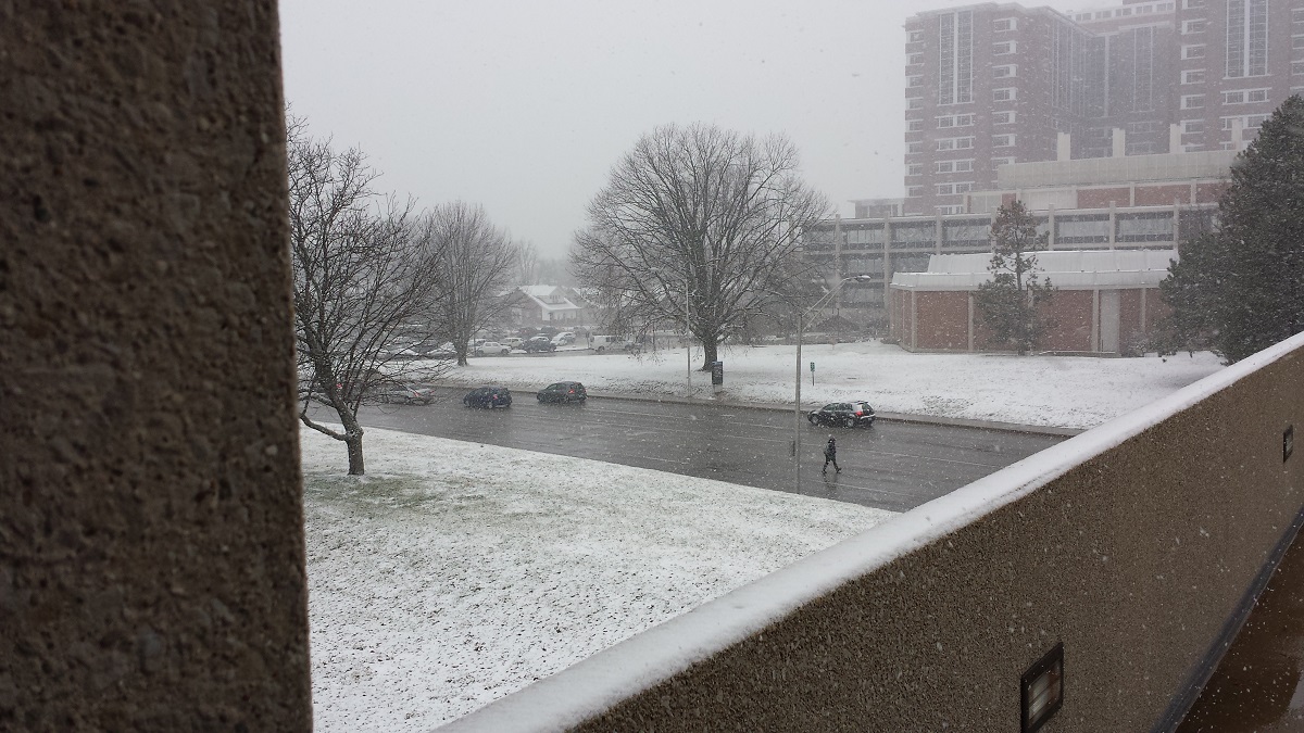
Morning of 8/25
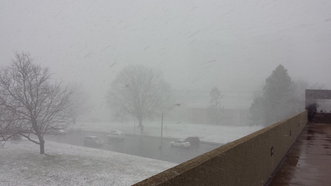
Afternoon of 8/25
 Kentucky Climate Summary
For the Period November 17, 2014 to November 23, 2014
Much Below Normal Temperatures and Above Normal Precipitation:
A winter-like weather pattern was the highlight of this past period. The work week
started off with an early season winter storm as low pressure meandered along the
Appalachian Mountains. Record cold air filtered into Kentucky on the backside of the
system, transitioning any rain to snow as Monday morning progressed. Snowfall totals
were most significant along the Ohio River, where most locations saw 3 to 5 inches.
Accumulations then gradually decreased to the southeast. Attention then turned toward
the northwest as the Commonwealth got another shot of Arctic air. Lows fell into the
teens Monday and Tuesday night. Some locations even dipped into the single digits.
Highs on Tuesday were only in the 20s, which was roughly 30 degrees below normal.
Wind chills dipped into the single digits for an extended period of time, prompting
the livestock cold stress index to fall into the emergency category. Temperatures
were finally on the upward swing on Friday and eventually went above normal over the
weekend. Widespread rain showers developed on Sunday and helped to end a 4 week span
of below normal precipitation as the state averaged slightly more than an inch.
Temperatures for the period averaged 35 degrees across the state which was 11 degrees
cooler than normal and 2 degrees cooler than the previous period. High temperatures
averaged from 46 in the West to 45 in the East. Departure from normal high
temperatures ranged from 11 degrees cooler than normal in the West to 11 degrees
cooler than normal in the East. Low temperatures averaged from 27 degrees in the
West to 25 degrees in the East. Departure from normal low temperature ranged from 10
degrees cooler than normal in the West to 8 degrees cooler than normal in the East.
The extreme high temperature for the period was 67 degrees at CADIZ 4SW and the
extreme low was 2 degrees at HENDERSON 5E. Kentucky has experienced 5 straight
weeks of below normal temperatures.
Precipitation (liq. equ.) for the period totaled 1.05 inches statewide which was 0.06
inches above normal and 106% of normal. Precipitation totals by climate division,
West 0.95 inches, Central 1.12 inches, Bluegrass 1.08 inches and East 1.04 inches,
which was -0.19, 0.07, 0.22 and 0.14 inches respectively from normal. By station,
precipitation totals ranged from a low of 0.52 inches at FORT CAMPBELL to a high of
1.59 inches at ALBANY 1N.
---
USDA's Kentucky Crop and Weather Report
Issued 4:00 P.M., November 17, 2014, 33-14
Agricultural News: Kentucky experienced below normal temperatures and below normal
precipitation over the past week. Precipitation for the week totaled 0.29 inches,
0.58 inches below normal. Temperatures averaged 38 degrees for the week, 11 degrees
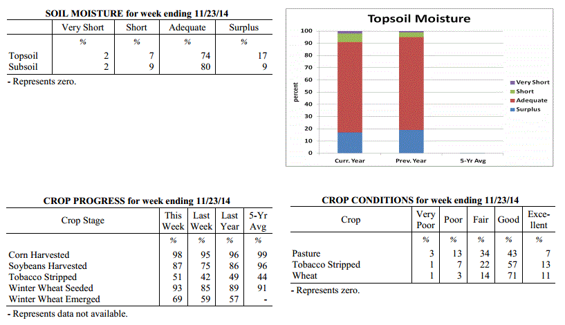
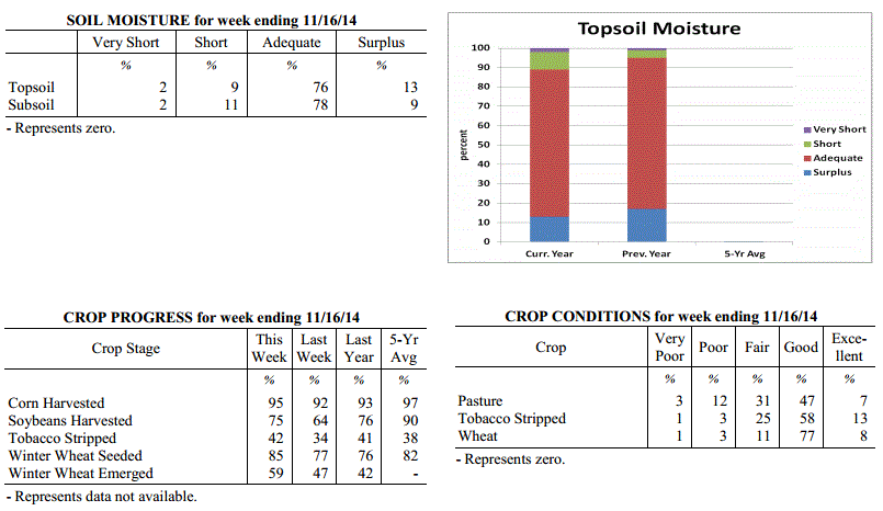
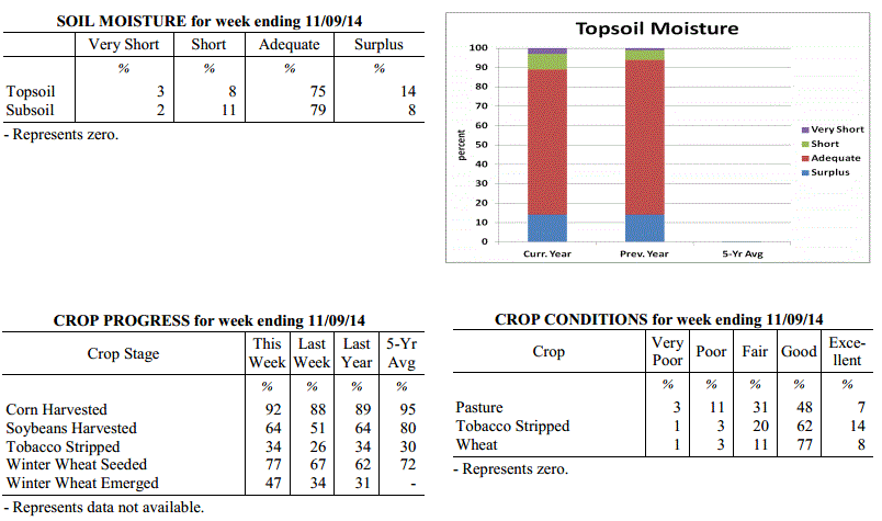
below normal. Topsoil moisture was rated 2 percent very short, 9 percent short, 76
percent adequate and 13 percent surplus. Subsoil moisture was rated 2 percent very
short, 11 percent short, 78 percent adequate, and 9 percent surplus. Days suitable
for fieldwork averaged 5.1 out of a possible seven.
Primary activities this week included stripping tobacco and harvesting crops. Some
farmers experienced delays in these activities due to cold and wet conditions.
Kentucky Climate Summary
For the Period November 17, 2014 to November 23, 2014
Much Below Normal Temperatures and Above Normal Precipitation:
A winter-like weather pattern was the highlight of this past period. The work week
started off with an early season winter storm as low pressure meandered along the
Appalachian Mountains. Record cold air filtered into Kentucky on the backside of the
system, transitioning any rain to snow as Monday morning progressed. Snowfall totals
were most significant along the Ohio River, where most locations saw 3 to 5 inches.
Accumulations then gradually decreased to the southeast. Attention then turned toward
the northwest as the Commonwealth got another shot of Arctic air. Lows fell into the
teens Monday and Tuesday night. Some locations even dipped into the single digits.
Highs on Tuesday were only in the 20s, which was roughly 30 degrees below normal.
Wind chills dipped into the single digits for an extended period of time, prompting
the livestock cold stress index to fall into the emergency category. Temperatures
were finally on the upward swing on Friday and eventually went above normal over the
weekend. Widespread rain showers developed on Sunday and helped to end a 4 week span
of below normal precipitation as the state averaged slightly more than an inch.
Temperatures for the period averaged 35 degrees across the state which was 11 degrees
cooler than normal and 2 degrees cooler than the previous period. High temperatures
averaged from 46 in the West to 45 in the East. Departure from normal high
temperatures ranged from 11 degrees cooler than normal in the West to 11 degrees
cooler than normal in the East. Low temperatures averaged from 27 degrees in the
West to 25 degrees in the East. Departure from normal low temperature ranged from 10
degrees cooler than normal in the West to 8 degrees cooler than normal in the East.
The extreme high temperature for the period was 67 degrees at CADIZ 4SW and the
extreme low was 2 degrees at HENDERSON 5E. Kentucky has experienced 5 straight
weeks of below normal temperatures.
Precipitation (liq. equ.) for the period totaled 1.05 inches statewide which was 0.06
inches above normal and 106% of normal. Precipitation totals by climate division,
West 0.95 inches, Central 1.12 inches, Bluegrass 1.08 inches and East 1.04 inches,
which was -0.19, 0.07, 0.22 and 0.14 inches respectively from normal. By station,
precipitation totals ranged from a low of 0.52 inches at FORT CAMPBELL to a high of
1.59 inches at ALBANY 1N.
---
USDA's Kentucky Crop and Weather Report
Issued 4:00 P.M., November 17, 2014, 33-14
Agricultural News: Kentucky experienced below normal temperatures and below normal
precipitation over the past week. Precipitation for the week totaled 0.29 inches,
0.58 inches below normal. Temperatures averaged 38 degrees for the week, 11 degrees
below normal. Topsoil moisture was rated 2 percent very short, 9 percent short, 76
percent adequate and 13 percent surplus. Subsoil moisture was rated 2 percent very
short, 11 percent short, 78 percent adequate, and 9 percent surplus. Days suitable
for fieldwork averaged 5.1 out of a possible seven.
Primary activities this week included stripping tobacco and harvesting crops. Some
farmers experienced delays in these activities due to cold and wet conditions.
 Kentucky Climate Summary
For the Period November 10, 2014 to November 16, 2014
Much Below Normal Temperatures and Below Normal Precipitation:
Believe it or not, Arctic air this past week led to the highest below normal
deviation in temperatures that the Commonwealth had seen all year. Over the course of
the period, the average statewide temperature stood at 38 degrees, which is 11
degrees below normal. The frigid period started after a cold front moved through the
area on Tuesday. Behind the boundary, Arctic high pressure proceeded to build into
the area over the next few days. Highs only peaked in the 30s for most through
Friday. Lows were coolest Friday night as high pressure moved overhead. Clear skies
and a calm wind allowed for the mercury to plummet into the upper teens to low 20s.
This is around 20 degrees below normal for this time of the year. Attention then
turned toward a couple disturbances pushing through the Ohio Valley over the weekend.
The first of the two on Saturday night only amounted to a dusting of snow for most.
The second was just starting as the period ended with light snow being reported in
Western Kentucky.
Temperatures for the period averaged 38 degrees across the state which was 11 degrees
cooler than normal and 10 degrees cooler than the previous period. High temperatures
averaged from 45 in the West to 48 in the East. Departure from normal high
temperatures ranged from 15 degrees cooler than normal in the West to 12 degrees
cooler than normal in the East. Low temperatures averaged from 29 degrees in the
West to 30 degrees in the East. Departure from normal low temperature ranged from 10
degrees cooler than normal in the West to 5 degrees cooler than normal in the East.
The extreme high temperature for the period was 74 degrees at BIG SANDY and the
extreme low was 10 degrees at BLACK MOUNTAIN ARC.
Precipitation (liq. equ.) for the period totaled 0.29 inches statewide which was 0.58
inches below normal and 33% of normal. Precipitation totals by climate division, West
0.21 inches, Central 0.39 inches, Bluegrass 0.19 inches and East 0.38 inches, which
was 0.83, 0.52, 0.56 and 0.4 inches below normal. By station, precipitation totals
ranged from a low of 0.03 inches at CARBONDALE ASOS to a high of 0.77 inches at
WHITLEY CITY 3N.
---
USDA's Kentucky Crop and Weather Report
Issued 4:00 P.M., November 10, 2014, 32-14
Agricultural News: Kentucky experienced below normal temperatures and rainfall over
the past week. Precipitation for the week totaled 0.72 inches, 0.05 inches below
normal. Temperatures averaged 48 degrees for the week, 3 degrees below normal.
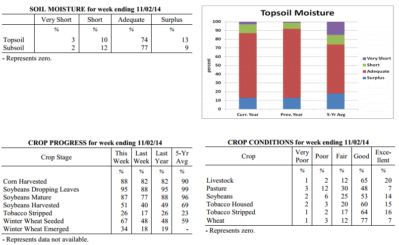
Topsoil moisture was rated 3 percent very short, 8 percent short, 75 percent adequate
and 14 percent surplus. Subsoil moisture was rated 2 percent very short, 11 percent
short, 79 percent adequate, and 8 percent surplus. Days suitable for fieldwork
averaged 4.4 out of a possible seven.
Primary activities this week included harvesting corn and soybeans. Producers were
also sowing wheat and stripping tobacco as conditions allowed. While some producers
have finished harvest, wet conditions have delayed harvest and many are behind
schedule. Tobacco in high case has prevented some growers from making more progress
on stripping. Cattle and calves obtained approximately 73 percent of feed from
pastures, but some hay is being fed.
Kentucky Climate Summary
For the Period November 10, 2014 to November 16, 2014
Much Below Normal Temperatures and Below Normal Precipitation:
Believe it or not, Arctic air this past week led to the highest below normal
deviation in temperatures that the Commonwealth had seen all year. Over the course of
the period, the average statewide temperature stood at 38 degrees, which is 11
degrees below normal. The frigid period started after a cold front moved through the
area on Tuesday. Behind the boundary, Arctic high pressure proceeded to build into
the area over the next few days. Highs only peaked in the 30s for most through
Friday. Lows were coolest Friday night as high pressure moved overhead. Clear skies
and a calm wind allowed for the mercury to plummet into the upper teens to low 20s.
This is around 20 degrees below normal for this time of the year. Attention then
turned toward a couple disturbances pushing through the Ohio Valley over the weekend.
The first of the two on Saturday night only amounted to a dusting of snow for most.
The second was just starting as the period ended with light snow being reported in
Western Kentucky.
Temperatures for the period averaged 38 degrees across the state which was 11 degrees
cooler than normal and 10 degrees cooler than the previous period. High temperatures
averaged from 45 in the West to 48 in the East. Departure from normal high
temperatures ranged from 15 degrees cooler than normal in the West to 12 degrees
cooler than normal in the East. Low temperatures averaged from 29 degrees in the
West to 30 degrees in the East. Departure from normal low temperature ranged from 10
degrees cooler than normal in the West to 5 degrees cooler than normal in the East.
The extreme high temperature for the period was 74 degrees at BIG SANDY and the
extreme low was 10 degrees at BLACK MOUNTAIN ARC.
Precipitation (liq. equ.) for the period totaled 0.29 inches statewide which was 0.58
inches below normal and 33% of normal. Precipitation totals by climate division, West
0.21 inches, Central 0.39 inches, Bluegrass 0.19 inches and East 0.38 inches, which
was 0.83, 0.52, 0.56 and 0.4 inches below normal. By station, precipitation totals
ranged from a low of 0.03 inches at CARBONDALE ASOS to a high of 0.77 inches at
WHITLEY CITY 3N.
---
USDA's Kentucky Crop and Weather Report
Issued 4:00 P.M., November 10, 2014, 32-14
Agricultural News: Kentucky experienced below normal temperatures and rainfall over
the past week. Precipitation for the week totaled 0.72 inches, 0.05 inches below
normal. Temperatures averaged 48 degrees for the week, 3 degrees below normal.
Topsoil moisture was rated 3 percent very short, 8 percent short, 75 percent adequate
and 14 percent surplus. Subsoil moisture was rated 2 percent very short, 11 percent
short, 79 percent adequate, and 8 percent surplus. Days suitable for fieldwork
averaged 4.4 out of a possible seven.
Primary activities this week included harvesting corn and soybeans. Producers were
also sowing wheat and stripping tobacco as conditions allowed. While some producers
have finished harvest, wet conditions have delayed harvest and many are behind
schedule. Tobacco in high case has prevented some growers from making more progress
on stripping. Cattle and calves obtained approximately 73 percent of feed from
pastures, but some hay is being fed.
 Kentucky Climate Summary
For the Period November 3, 2014 to November 9, 2014
Below Normal Temperatures and Rainfall:
Fall transition was in full swing this past period with the Bluegrass State seeing
the thermometer rise and dive on numerous occasions. The work week started off fairly
mild for early November as surface high pressure was positioned east of the area.
Southwesterly flow, breezy at times, pushed highs into the 60s on both Monday and
Tuesday. Conditions then went on the decline for the next couple days as a cold front
made slow progress across the area. Light to moderate rainfall was widespread in
coverage with most locations picking up a half to one inch with the highest amounts
across Eastern Kentucky. Surface high pressure moved back into the area for the end
of the work week. Highs only topped out in the mid 40s to low 50s on Friday with
lows dipping into the upper 20s to mid 30s. The Commonwealth did see the mercury climb
once again over the weekend, but it was not enough to deny a third straight week of
below normal temperatures.
Temperatures for the period averaged 48 degrees across the state which was 3 degrees
cooler than normal and 2 degrees cooler than the previous period. High temperatures
averaged from 58 in the West to 58 in the East. Departure from normal high
temperatures ranged from 5 degrees cooler than normal in the West to 5 degrees cooler
than normal in the East. Low temperatures averaged from 40 degrees in the West to 39
degrees in the East. Departure from normal low temperature ranged from 1 degree
cooler than normal in the West to 2 degrees warmer than normal in the East. The
extreme high temperature for the period for the period was 70 degrees at BURKESVILLE
3W and the extreme low was 23 degrees at VANCEBURG 6W.
Precipitation (liq. equ.) for the period totaled 0.72 inches statewide which was 0.05
inches below normal and 93% of normal. Precipitation totals by climate division, West
0.60 inches, Central 0.84 inches, Bluegrass 0.47 inches and East 0.99 inches, which
was -0.28, 0.04, -0.23 and 0.28 inches respectively from normal. By station,
precipitation totals ranged from a low of 0.11 inches at CINCINNATI to a high of 1.70
inches at YELLOW CREEK.
---
USDA's Kentucky Crop and Weather Report
Issued 4:00 P.M., November 3, 2014, 31-14
Agricultural News: Kentucky experienced colder weather this past week. Precipitation
for the week totaled 0.65 inches, 0.12 inches below normal. Temperatures averaged 50
degrees for the week, 3 degrees below normal. Topsoil moisture was rated 3 percent
very short, 10 percent short, 74 percent adequate and 13 percent surplus. Subsoil
moisture was rated 2 percent very short, 12 percent short, 77 percent adequate, and 9
percent surplus. Days suitable for fieldwork averaged 5.2 out of a possible seven.
Primary activities this week included planting wheat, harvesting corn and soybeans,
and tending to livestock.
Kentucky Climate Summary
For the Period November 3, 2014 to November 9, 2014
Below Normal Temperatures and Rainfall:
Fall transition was in full swing this past period with the Bluegrass State seeing
the thermometer rise and dive on numerous occasions. The work week started off fairly
mild for early November as surface high pressure was positioned east of the area.
Southwesterly flow, breezy at times, pushed highs into the 60s on both Monday and
Tuesday. Conditions then went on the decline for the next couple days as a cold front
made slow progress across the area. Light to moderate rainfall was widespread in
coverage with most locations picking up a half to one inch with the highest amounts
across Eastern Kentucky. Surface high pressure moved back into the area for the end
of the work week. Highs only topped out in the mid 40s to low 50s on Friday with
lows dipping into the upper 20s to mid 30s. The Commonwealth did see the mercury climb
once again over the weekend, but it was not enough to deny a third straight week of
below normal temperatures.
Temperatures for the period averaged 48 degrees across the state which was 3 degrees
cooler than normal and 2 degrees cooler than the previous period. High temperatures
averaged from 58 in the West to 58 in the East. Departure from normal high
temperatures ranged from 5 degrees cooler than normal in the West to 5 degrees cooler
than normal in the East. Low temperatures averaged from 40 degrees in the West to 39
degrees in the East. Departure from normal low temperature ranged from 1 degree
cooler than normal in the West to 2 degrees warmer than normal in the East. The
extreme high temperature for the period for the period was 70 degrees at BURKESVILLE
3W and the extreme low was 23 degrees at VANCEBURG 6W.
Precipitation (liq. equ.) for the period totaled 0.72 inches statewide which was 0.05
inches below normal and 93% of normal. Precipitation totals by climate division, West
0.60 inches, Central 0.84 inches, Bluegrass 0.47 inches and East 0.99 inches, which
was -0.28, 0.04, -0.23 and 0.28 inches respectively from normal. By station,
precipitation totals ranged from a low of 0.11 inches at CINCINNATI to a high of 1.70
inches at YELLOW CREEK.
---
USDA's Kentucky Crop and Weather Report
Issued 4:00 P.M., November 3, 2014, 31-14
Agricultural News: Kentucky experienced colder weather this past week. Precipitation
for the week totaled 0.65 inches, 0.12 inches below normal. Temperatures averaged 50
degrees for the week, 3 degrees below normal. Topsoil moisture was rated 3 percent
very short, 10 percent short, 74 percent adequate and 13 percent surplus. Subsoil
moisture was rated 2 percent very short, 12 percent short, 77 percent adequate, and 9
percent surplus. Days suitable for fieldwork averaged 5.2 out of a possible seven.
Primary activities this week included planting wheat, harvesting corn and soybeans,
and tending to livestock.
 Kentucky Climate Summary
For the Period October 27, 2014 to November 2, 2014
Below Normal Temperatures and Rainfall:
It seemed that the Commonwealth saw a glimpse of each season this past period, with
the last resulting in the end of the growing season. A warm front pushed north of
Kentucky on Monday, pushing temperatures well above normal for the end of October.
Breezy southwesterly flow sent highs soaring into the low to middle 80s. Louisville
rose to 85 degrees, breaking a record that had stood since 1940. Conditions then took
a downhill turn as a cold front pushed through the area on Tuesday, spreading showers
across the area. Rainfall totals were below a half inch for much of the state. The
one exception came across Eastern Kentucky, where a narrow corridor saw between 1 to
2 inches. After a couple days of typical fall conditions, Kentuckians got a glimpse
of winter on Friday and Saturday as another cold front pushed through the Ohio
Valley. Behind the boundary, winds became gusty from the northwest, dropping
temperatures to around freezing by Saturday morning. Some locations across the
eastern half of the state saw some snow, but other than some of the higher
elevations, accumulations were minor due to warm ground temperatures. High pressure
of Canadian origin then built overhead Saturday night. Clear skies and a calm wind
allowed for a killing freeze as the mercury dipped into the low to mid 20s area wide,
effectively bringing an end to the growing season.
Temperatures for the period averaged 50 degrees across the state which was 3 degrees
cooler than normal and 4 degrees cooler than the previous period. High temperatures
averaged from 62 in the West to 58 in the East. Departure from normal high
temperatures ranged from 4 degrees cooler than normal in the West to 8 degrees
cooler than normal in the East. Low temperatures averaged from 41 degrees in the
West to 40 degrees in the East. Departure from normal low temperature ranged from 2
degrees cooler than normal in the West to 1 degree warmer than normal in the East.
The extreme high temperature for the period was 85 degrees at LOUISVILLE APT and the
extreme low was 19 degrees at WILLIAMSBURG AWOS.
Precipitation (liq. equ.) for the period totaled 0.65 inches statewide which was 0.12
inches below normal and 84% of normal. Precipitation totals by climate division, West
0.46 inches, Central 0.43 inches, Bluegrass 0.53 inches and East 1.16 inches, which
was -0.40, -0.37, -0.18 and 0.44 inches respectively from normal. By station,
precipitation totals ranged from a low of 0.11 inches at HARDINSBURG 5SW to a high of
2.09 inches at BARBOURVILLE 3E.
---
USDA's Kentucky Crop and Weather Report
Issued 4:00 P.M., October 27, 2014, 30-14
Agricultural News: Kentucky experienced drier conditions over the past week.
Precipitation for the week totaled 0.03 inches, 0.67 inches below normal.
Temperatures averaged 54 degrees for the week, 2 degrees below normal. Topsoil
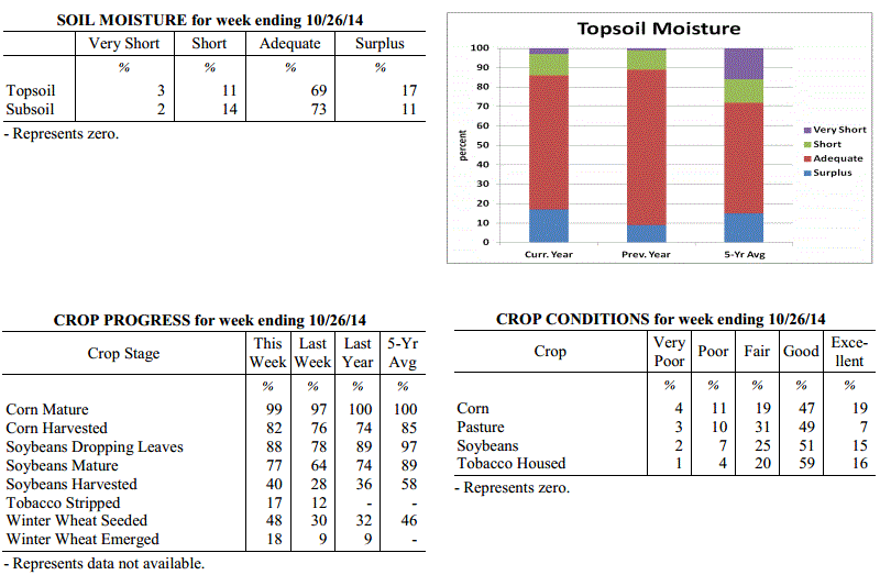
moisture was rated 3 percent very short, 11 percent short, 69 percent adequate and 17
percent surplus. Subsoil moisture was rated 2 percent very short, 14 percent short,
73 percent adequate, and 11 percent surplus. Days suitable for fieldwork averaged 5.8
out of a possible seven.
Primary activities this week included harvesting corn and soybeans and planting
winter wheat as fields finally got a chance to dry out. Seventeen percent of tobacco
has been stripped, with 29 percent ready to be stripped and 54 percent not ready for
stripping.
Kentucky Climate Summary
For the Period October 27, 2014 to November 2, 2014
Below Normal Temperatures and Rainfall:
It seemed that the Commonwealth saw a glimpse of each season this past period, with
the last resulting in the end of the growing season. A warm front pushed north of
Kentucky on Monday, pushing temperatures well above normal for the end of October.
Breezy southwesterly flow sent highs soaring into the low to middle 80s. Louisville
rose to 85 degrees, breaking a record that had stood since 1940. Conditions then took
a downhill turn as a cold front pushed through the area on Tuesday, spreading showers
across the area. Rainfall totals were below a half inch for much of the state. The
one exception came across Eastern Kentucky, where a narrow corridor saw between 1 to
2 inches. After a couple days of typical fall conditions, Kentuckians got a glimpse
of winter on Friday and Saturday as another cold front pushed through the Ohio
Valley. Behind the boundary, winds became gusty from the northwest, dropping
temperatures to around freezing by Saturday morning. Some locations across the
eastern half of the state saw some snow, but other than some of the higher
elevations, accumulations were minor due to warm ground temperatures. High pressure
of Canadian origin then built overhead Saturday night. Clear skies and a calm wind
allowed for a killing freeze as the mercury dipped into the low to mid 20s area wide,
effectively bringing an end to the growing season.
Temperatures for the period averaged 50 degrees across the state which was 3 degrees
cooler than normal and 4 degrees cooler than the previous period. High temperatures
averaged from 62 in the West to 58 in the East. Departure from normal high
temperatures ranged from 4 degrees cooler than normal in the West to 8 degrees
cooler than normal in the East. Low temperatures averaged from 41 degrees in the
West to 40 degrees in the East. Departure from normal low temperature ranged from 2
degrees cooler than normal in the West to 1 degree warmer than normal in the East.
The extreme high temperature for the period was 85 degrees at LOUISVILLE APT and the
extreme low was 19 degrees at WILLIAMSBURG AWOS.
Precipitation (liq. equ.) for the period totaled 0.65 inches statewide which was 0.12
inches below normal and 84% of normal. Precipitation totals by climate division, West
0.46 inches, Central 0.43 inches, Bluegrass 0.53 inches and East 1.16 inches, which
was -0.40, -0.37, -0.18 and 0.44 inches respectively from normal. By station,
precipitation totals ranged from a low of 0.11 inches at HARDINSBURG 5SW to a high of
2.09 inches at BARBOURVILLE 3E.
---
USDA's Kentucky Crop and Weather Report
Issued 4:00 P.M., October 27, 2014, 30-14
Agricultural News: Kentucky experienced drier conditions over the past week.
Precipitation for the week totaled 0.03 inches, 0.67 inches below normal.
Temperatures averaged 54 degrees for the week, 2 degrees below normal. Topsoil
moisture was rated 3 percent very short, 11 percent short, 69 percent adequate and 17
percent surplus. Subsoil moisture was rated 2 percent very short, 14 percent short,
73 percent adequate, and 11 percent surplus. Days suitable for fieldwork averaged 5.8
out of a possible seven.
Primary activities this week included harvesting corn and soybeans and planting
winter wheat as fields finally got a chance to dry out. Seventeen percent of tobacco
has been stripped, with 29 percent ready to be stripped and 54 percent not ready for
stripping.
 Kentucky Climate Summary
For the Period October 20, 2014 to October 26, 2014
Below Normal Temperatures and Rainfall:
After two straight weeks of much above normal rainfall, the Commonwealth finally got
a chance to dry out this past period. The only mentionable precipitation came Monday
and Tuesday as a couple weak disturbances passed through the region. Showers were
light in nature with the majority of rainfall totals under a tenth of an inch.
Starting Wednesday, the Bluegrass State was under the influence of high pressure for
most of the remainder of the week. This kept conditions dry with focus turning to
temperatures. The coolest readings came Wednesday night and into Thursday morning.
Much of Western and Central Kentucky saw lows dip into the low to mid 30s. Cloud
cover kept the mercury elevated in Eastern Kentucky. After a cool work week,
temperatures became mild for the weekend. Highs rose into the 70s for most. A
handful of locations in Western Kentucky reached the lower 80s, well above normal
for this time of the year.
Temperatures for the period averaged 54 degrees across the state which was 2 degrees
cooler than normal and 4 degrees cooler than the previous period. High temperatures
averaged from 71 in the West to 63 in the East. Departure from normal high
temperatures ranged from 1 degree warmer than normal in the West to 5 degrees
cooler than normal in the East. Low temperatures averaged from 43 degrees in the
West to 42 degrees in the East. Departure from normal low temperature ranged from 2
degrees cooler than normal in the West to 1 degree warmer than normal in the East.
The extreme high temperature for the period was 84 degrees at POPLAR BLUFF ASOS and
the extreme low was 31 degrees at BRANDENBURG 4SW.
Precipitation (liq. equ.) for the period totaled 0.03 inches statewide which was 0.67
inches below normal and 4% of normal. Precipitation totals by climate division, West
0.01 inches, Central 0.03 inches, Bluegrass 0.05 inches and East 0.04 inches, which
was 0.78, 0.68, 0.6 and 0.63 inches below normal. By station, precipitation totals
ranged from a low of 0.00 inches at ALBANY 1N to a high of 0.19 inches at LOUISVILLE APT.
---
USDA's Kentucky Crop and Weather Report
Issued 4:00 P.M., October 20, 2014, 29-14
Agricultural News: Kentucky experienced very rainy conditions over the past week.
Precipitation for the week totaled 2.05 inches, 1.34 inches above normal.
Temperatures averaged 59 degrees for the week, 2 degrees above normal. Topsoil
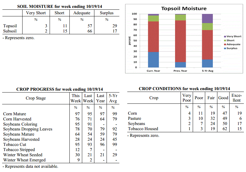
moisture was rated 3 percent very short, 11 percent short, 57 percent adequate and 29
percent surplus. Subsoil moisture was rated 2 percent very short, 15 percent short,
66 percent adequate, and 17 percent surplus. Days suitable for fieldwork averaged 1.9
out of a possible seven.
Primary activities this week included harvesting corn and soybeans and planting
winter wheat when conditions allowed. Rainfall has continued to slow harvest and some
hail damage was reported on tobacco and corn in the Bluegrass area. Twelve percent of
tobacco has been stripped, with 22 percent ready to be stripped and 66
percent not ready for stripping.
Kentucky Climate Summary
For the Period October 20, 2014 to October 26, 2014
Below Normal Temperatures and Rainfall:
After two straight weeks of much above normal rainfall, the Commonwealth finally got
a chance to dry out this past period. The only mentionable precipitation came Monday
and Tuesday as a couple weak disturbances passed through the region. Showers were
light in nature with the majority of rainfall totals under a tenth of an inch.
Starting Wednesday, the Bluegrass State was under the influence of high pressure for
most of the remainder of the week. This kept conditions dry with focus turning to
temperatures. The coolest readings came Wednesday night and into Thursday morning.
Much of Western and Central Kentucky saw lows dip into the low to mid 30s. Cloud
cover kept the mercury elevated in Eastern Kentucky. After a cool work week,
temperatures became mild for the weekend. Highs rose into the 70s for most. A
handful of locations in Western Kentucky reached the lower 80s, well above normal
for this time of the year.
Temperatures for the period averaged 54 degrees across the state which was 2 degrees
cooler than normal and 4 degrees cooler than the previous period. High temperatures
averaged from 71 in the West to 63 in the East. Departure from normal high
temperatures ranged from 1 degree warmer than normal in the West to 5 degrees
cooler than normal in the East. Low temperatures averaged from 43 degrees in the
West to 42 degrees in the East. Departure from normal low temperature ranged from 2
degrees cooler than normal in the West to 1 degree warmer than normal in the East.
The extreme high temperature for the period was 84 degrees at POPLAR BLUFF ASOS and
the extreme low was 31 degrees at BRANDENBURG 4SW.
Precipitation (liq. equ.) for the period totaled 0.03 inches statewide which was 0.67
inches below normal and 4% of normal. Precipitation totals by climate division, West
0.01 inches, Central 0.03 inches, Bluegrass 0.05 inches and East 0.04 inches, which
was 0.78, 0.68, 0.6 and 0.63 inches below normal. By station, precipitation totals
ranged from a low of 0.00 inches at ALBANY 1N to a high of 0.19 inches at LOUISVILLE APT.
---
USDA's Kentucky Crop and Weather Report
Issued 4:00 P.M., October 20, 2014, 29-14
Agricultural News: Kentucky experienced very rainy conditions over the past week.
Precipitation for the week totaled 2.05 inches, 1.34 inches above normal.
Temperatures averaged 59 degrees for the week, 2 degrees above normal. Topsoil
moisture was rated 3 percent very short, 11 percent short, 57 percent adequate and 29
percent surplus. Subsoil moisture was rated 2 percent very short, 15 percent short,
66 percent adequate, and 17 percent surplus. Days suitable for fieldwork averaged 1.9
out of a possible seven.
Primary activities this week included harvesting corn and soybeans and planting
winter wheat when conditions allowed. Rainfall has continued to slow harvest and some
hail damage was reported on tobacco and corn in the Bluegrass area. Twelve percent of
tobacco has been stripped, with 22 percent ready to be stripped and 66
percent not ready for stripping.
 Kentucky Climate Summary
For the Period October 13, 2014 to October 19, 2014
Above Normal Temperatures and Rainfall:
The showers kept on coming this past period as the state averaged over 2 inches for
the second straight week. The wet pattern continued as a cold front made slow
progression across the Commonwealth Monday and Tuesday. A squall line pushed through
the area Monday evening, before diminishing in strength going into the overnight
period and Tuesday. Showers were widespread across the area with most picking up
between 1 to 3 inches. Scattered to numerous light showers then continued to fall
Wednesday and Thursday as an upper level area of low pressure meandered across the
region. This just added to an extremely wet first half of October. Over the past 2
weeks, the Commonwealth has averaged over 4 inches of rainfall. This is more than
what the state normally sees over the entire month of October. Preliminary data at
the Ag Weather Center suggest that the Commonwealth has already cracked the top
20 for the wettest October periods on record.
Temperatures for the period averaged 59 degrees across the state which was 2 degrees
warmer than normal and 2 degrees cooler than the previous period. High temperatures
averaged from 67 in the West to 66 in the East. Departure from normal high
temperatures ranged from 5 degrees cooler than normal in the West to 4 degrees
cooler than normal in the East. Low temperatures averaged from 51 degrees in the
West to 52 degrees in the East. Departure from normal low temperature ranged from 4
degrees warmer than normal in the West to 9 degrees warmer than normal in the East.
The extreme high temperature for the period was 82 degrees at LOUISA 1S and the
extreme low was 34 degrees at CARBONDALE ASOS.
Precipitation (liq. equ.) for the period totaled 2.05 inches statewide which was 1.34
inches above normal and 291% of normal. Precipitation totals by climate division,
West 2.21 inches, Central 2.55 inches, Bluegrass 1.74 inches and East 1.69 inches,
which was 1.47, 1.83, 1.07 and 1 inches above normal. By station, precipitation
totals ranged from a low of 0.80 inches at CAPE GIRARDEAU ASOS to a high of 4.05
inches at ELKTON 5SW.
---
USDA's Kentucky Crop and Weather Report
Issued 4:00 P.M., October 14, 2014, 28-14
Agricultural News: Kentucky experienced scattered severe weather over the past week.
Precipitation for the week totaled 2.23 inches, 1.46 inches above normal.
Temperatures averaged 61 degrees for the week, 1 degree above normal. Topsoil
moisture was rated 5 percent very short, 20 percent short, 60 percent adequate and 15
percent surplus. Subsoil moisture was rated 4 percent very short, 23 percent short,
65 percent adequate, and 8 percent surplus. Days suitable for fieldwork averaged 3.8
out of a possible seven.
Primary activities this week included harvesting corn and soybeans and planting
winter wheat. Continued rainfall has slowed harvests and some areas of the state
reported damage from large hail. A tornado touched down in the northern part of the
state which resulted in damage and loss of stored hay and housed tobacco. Tobacco
houseburn was reported as 1 percent heavy, 6 percent moderate, 16 percent light, with
77 percent experiencing none. Seven percent of tobacco has been stripped, with 18 percent
ready to be stripped and 75 percent not ready for stripping.
Kentucky Climate Summary
For the Period October 13, 2014 to October 19, 2014
Above Normal Temperatures and Rainfall:
The showers kept on coming this past period as the state averaged over 2 inches for
the second straight week. The wet pattern continued as a cold front made slow
progression across the Commonwealth Monday and Tuesday. A squall line pushed through
the area Monday evening, before diminishing in strength going into the overnight
period and Tuesday. Showers were widespread across the area with most picking up
between 1 to 3 inches. Scattered to numerous light showers then continued to fall
Wednesday and Thursday as an upper level area of low pressure meandered across the
region. This just added to an extremely wet first half of October. Over the past 2
weeks, the Commonwealth has averaged over 4 inches of rainfall. This is more than
what the state normally sees over the entire month of October. Preliminary data at
the Ag Weather Center suggest that the Commonwealth has already cracked the top
20 for the wettest October periods on record.
Temperatures for the period averaged 59 degrees across the state which was 2 degrees
warmer than normal and 2 degrees cooler than the previous period. High temperatures
averaged from 67 in the West to 66 in the East. Departure from normal high
temperatures ranged from 5 degrees cooler than normal in the West to 4 degrees
cooler than normal in the East. Low temperatures averaged from 51 degrees in the
West to 52 degrees in the East. Departure from normal low temperature ranged from 4
degrees warmer than normal in the West to 9 degrees warmer than normal in the East.
The extreme high temperature for the period was 82 degrees at LOUISA 1S and the
extreme low was 34 degrees at CARBONDALE ASOS.
Precipitation (liq. equ.) for the period totaled 2.05 inches statewide which was 1.34
inches above normal and 291% of normal. Precipitation totals by climate division,
West 2.21 inches, Central 2.55 inches, Bluegrass 1.74 inches and East 1.69 inches,
which was 1.47, 1.83, 1.07 and 1 inches above normal. By station, precipitation
totals ranged from a low of 0.80 inches at CAPE GIRARDEAU ASOS to a high of 4.05
inches at ELKTON 5SW.
---
USDA's Kentucky Crop and Weather Report
Issued 4:00 P.M., October 14, 2014, 28-14
Agricultural News: Kentucky experienced scattered severe weather over the past week.
Precipitation for the week totaled 2.23 inches, 1.46 inches above normal.
Temperatures averaged 61 degrees for the week, 1 degree above normal. Topsoil
moisture was rated 5 percent very short, 20 percent short, 60 percent adequate and 15
percent surplus. Subsoil moisture was rated 4 percent very short, 23 percent short,
65 percent adequate, and 8 percent surplus. Days suitable for fieldwork averaged 3.8
out of a possible seven.
Primary activities this week included harvesting corn and soybeans and planting
winter wheat. Continued rainfall has slowed harvests and some areas of the state
reported damage from large hail. A tornado touched down in the northern part of the
state which resulted in damage and loss of stored hay and housed tobacco. Tobacco
houseburn was reported as 1 percent heavy, 6 percent moderate, 16 percent light, with
77 percent experiencing none. Seven percent of tobacco has been stripped, with 18 percent
ready to be stripped and 75 percent not ready for stripping.
 Kentucky Climate Summary
For the Period October 6, 2014 to October 12, 2014
Above Normal Temperatures and Rainfall:
The second week of October brought one of the more active severe weather periods the
Commonwealth has seen in quite some time. An unsettled pattern was setup to begin
the work week with multiple upper level disturbances passing through the region. Each
wave sparked scattered to numerous showers and storms across the Commonwealth.
Supercell thunderstorms developed in some cases, leading to the development of multiple
tornadoes, large hail, and damaging winds. The most prominent system came Tuesday
afternoon and evening with multiple reports of hail at the size of a golf ball and 9
confirmed tornadoes. Conditions temporarily dried out for Wednesday, before the wet
pattern continued for much of the remainder of the week. Multiple disturbances
overrode a frontal boundary hovering across the area, leading to several rounds of
showers and storms. For the week as a whole, the eastern portion of the state came
out the winners with over three inches on average. Nonetheless, the state as a whole
averaged over 2 inches, which was nearly 1.5 inches above normal. This brought an
end to a three week span of below average rainfall across the state.
Temperatures for the period averaged 61 degrees across the state which was 1 degrees
warmer than normal and 2 degrees cooler than the previous period. High temperatures
averaged from 73 in the West to 67 in the East. Departure from normal high
temperatures ranged from 1 degree cooler than normal in the West to 5 degrees cooler
than normal in the East. Low temperatures averaged from 54 degrees in the West to 52
degrees in the East. Departure from normal low temperature ranged from 5 degrees
warmer than normal in the West to 7 degrees warmer than normal in the East. The
extreme high temperature for the period for was 84 degrees at POPLAR BLUFF ASOS and
the extreme low was 40 degrees at CYNTHIANA 8N.
Precipitation (liq. equ.) for the period totaled 2.23 inches statewide which was 1.46
inches above normal and 290% of normal. Precipitation totals by climate division,
West 1.74 inches, Central 1.73 inches, Bluegrass 2.03 inches and East 3.40 inches,
which was 0.96, 0.93, 1.3 and 2.63 inches above normal. By station, precipitation
totals ranged from a low of 0.40 inches at BRANDENBURG 4SW to a high of 5.43
inches at YELLOW CREEK.
---
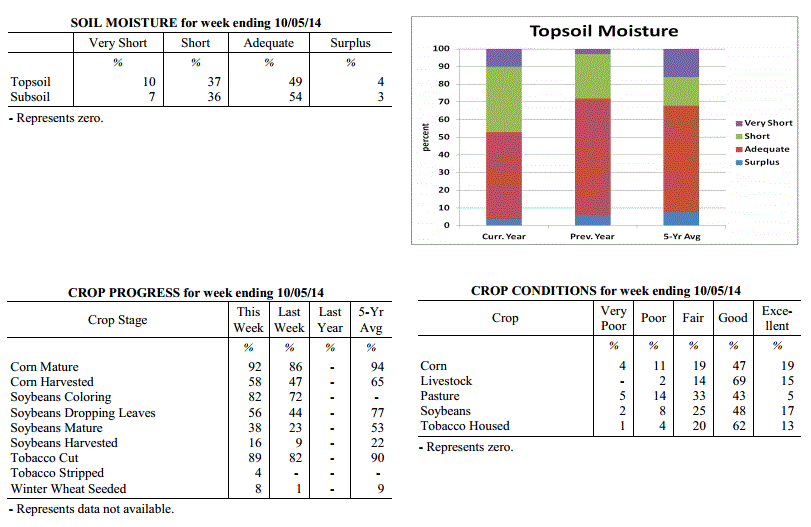
USDA's Kentucky Crop and Weather Report
Issued 4:00 P.M., October 6, 2014, 27-14
Agricultural News: Kentucky experienced above normal temperatures and below normal
rainfall over the past week. Precipitation for the week totaled 0.46 inches, 0.34
inches below normal. Temperatures averaged 64 degrees for the week, 2 degrees above
normal. Topsoil moisture was rated 10 percent very short, 37 percent short, 49
percent adequate and 4 percent surplus. Subsoil moisture was rated 7 percent very
short, 36 percent short, 54 percent adequate, and 3 percent surplus. Days suitable
for fieldwork averaged 6.1 out of a possible seven.
Primary activities this week included harvesting corn and some growers were beginning
to seed winter wheat. Early planted soybeans are also starting to be harvested.
Pasture conditions slightly decreased due to below normal rainfall and late planted
soybeans continued to show signs of drought stress. Tobacco houseburn was reported as
1 percent heavy, 5 percent moderate, 16 percent light, with 78 percent experiencing
none. Four percent of tobacco has been stripped, with 13 percent ready to be stripped
and 83 percent not ready for stripping.
Kentucky Climate Summary
For the Period October 6, 2014 to October 12, 2014
Above Normal Temperatures and Rainfall:
The second week of October brought one of the more active severe weather periods the
Commonwealth has seen in quite some time. An unsettled pattern was setup to begin
the work week with multiple upper level disturbances passing through the region. Each
wave sparked scattered to numerous showers and storms across the Commonwealth.
Supercell thunderstorms developed in some cases, leading to the development of multiple
tornadoes, large hail, and damaging winds. The most prominent system came Tuesday
afternoon and evening with multiple reports of hail at the size of a golf ball and 9
confirmed tornadoes. Conditions temporarily dried out for Wednesday, before the wet
pattern continued for much of the remainder of the week. Multiple disturbances
overrode a frontal boundary hovering across the area, leading to several rounds of
showers and storms. For the week as a whole, the eastern portion of the state came
out the winners with over three inches on average. Nonetheless, the state as a whole
averaged over 2 inches, which was nearly 1.5 inches above normal. This brought an
end to a three week span of below average rainfall across the state.
Temperatures for the period averaged 61 degrees across the state which was 1 degrees
warmer than normal and 2 degrees cooler than the previous period. High temperatures
averaged from 73 in the West to 67 in the East. Departure from normal high
temperatures ranged from 1 degree cooler than normal in the West to 5 degrees cooler
than normal in the East. Low temperatures averaged from 54 degrees in the West to 52
degrees in the East. Departure from normal low temperature ranged from 5 degrees
warmer than normal in the West to 7 degrees warmer than normal in the East. The
extreme high temperature for the period for was 84 degrees at POPLAR BLUFF ASOS and
the extreme low was 40 degrees at CYNTHIANA 8N.
Precipitation (liq. equ.) for the period totaled 2.23 inches statewide which was 1.46
inches above normal and 290% of normal. Precipitation totals by climate division,
West 1.74 inches, Central 1.73 inches, Bluegrass 2.03 inches and East 3.40 inches,
which was 0.96, 0.93, 1.3 and 2.63 inches above normal. By station, precipitation
totals ranged from a low of 0.40 inches at BRANDENBURG 4SW to a high of 5.43
inches at YELLOW CREEK.
---
USDA's Kentucky Crop and Weather Report
Issued 4:00 P.M., October 6, 2014, 27-14
Agricultural News: Kentucky experienced above normal temperatures and below normal
rainfall over the past week. Precipitation for the week totaled 0.46 inches, 0.34
inches below normal. Temperatures averaged 64 degrees for the week, 2 degrees above
normal. Topsoil moisture was rated 10 percent very short, 37 percent short, 49
percent adequate and 4 percent surplus. Subsoil moisture was rated 7 percent very
short, 36 percent short, 54 percent adequate, and 3 percent surplus. Days suitable
for fieldwork averaged 6.1 out of a possible seven.
Primary activities this week included harvesting corn and some growers were beginning
to seed winter wheat. Early planted soybeans are also starting to be harvested.
Pasture conditions slightly decreased due to below normal rainfall and late planted
soybeans continued to show signs of drought stress. Tobacco houseburn was reported as
1 percent heavy, 5 percent moderate, 16 percent light, with 78 percent experiencing
none. Four percent of tobacco has been stripped, with 13 percent ready to be stripped
and 83 percent not ready for stripping.
 Kentucky Climate Summary
For the Period September 29, 2014 to October 5, 2014
Above Normal Temperatures and Below Normal Rainfall:
This past period started out on the warm and dry side as surface high pressure was in
control. Daytime temperatures were slightly above normal for much of the period with
highs in the low to mid 80s Monday through Wednesday. Winds shifted to the south on
Thursday, ahead of an approaching cold front. This led to the warmest day of the week
with highs typically in the mid to upper 80s. Western Kentucky saw some scattered
showers and storms through the day, before coverage became widespread later Thursday
night and into Friday. Rainfall totals were around a quarter to half inch for the
majority of the state. This was the only significant rainfall event for the week
across Kentucky and led to the third week in a row of below normal precipitation.
Much cooler air rushed into the area behind the boundary with winds from the west
gusting to around 30 mph at times. Highs on Saturday only rose into the 50s for most,
before the coolest temperatures of the fall season were felt that night. Much of the
Commonwealth fell into the low to mid 30s as skies became mostly clear, prompting a
frost advisory across the state.
Temperatures for the period averaged 64 degrees across the state which was 2 degrees
warmer than normal and no change to the previous period. High temperatures averaged
from 79 in the West to 74 in the East. Departure from normal high temperatures ranged
from 3 degrees warmer than normal in the West to near normal in the East. Low
temperatures averaged from 51 degrees in the West to 52 degrees in the East.
Departure from normal low temperature ranged from 1 degree cooler than normal in the
West to 4 degrees warmer than normal in the East. The extreme high temperature for
the period was 91 degrees at OWENSBORO AWSS and the extreme low was 27 degrees at FORT
CAMPBELL.
Precipitation (liq. equ.) for the period totaled 0.46 inches statewide which was 0.34
inches below normal and 58% of normal. Precipitation totals by climate division, West
0.58 inches, Central 0.45 inches, Bluegrass 0.39 inches and East 0.42 inches, which
was 0.24, 0.4, 0.35 and 0.37 inches below normal. By station, precipitation totals
ranged from a low of 0.13 inches at OWENTON 5E to a high of 1.12 inches at HICKMAN 2E.
---
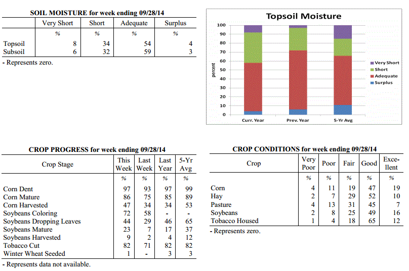
USDA's Kentucky Crop and Weather Report
Issued 4:00 P.M., September 29, 2014, 26-14
Agricultural News: Kentucky experienced below normal temperatures and rainfall over
the past week. Precipitation for the week totaled 0.00 inches, 0.85 inches below
normal. Temperatures averaged 64 degrees for the week, 2 degrees below normal.
Topsoil moisture was rated 8 percent very short, 34 percent short, 54 percent
adequate and 4 percent surplus. Subsoil moisture was rated 6 percent very short, 32
percent short, 59 percent adequate, and 3 percent surplus. Days suitable for
fieldwork averaged 6.7 out of a possible seven.
Primary activities this week included harvesting corn, baling hay, and housing
tobacco. Farmers continue to report difficulty finding labor to complete tobacco
harvest. Corn and soybeans continue to remain in good condition. Dry weather has
allowed farmers to make good progress on their crop harvest. Late planted soybeans
are in need of rain and are showing signs of stress. Tobacco houseburn was reported
as 1 percent heavy, 5 percent moderate, 16 percent light, with 78 percent
experiencing none.
Kentucky Climate Summary
For the Period September 29, 2014 to October 5, 2014
Above Normal Temperatures and Below Normal Rainfall:
This past period started out on the warm and dry side as surface high pressure was in
control. Daytime temperatures were slightly above normal for much of the period with
highs in the low to mid 80s Monday through Wednesday. Winds shifted to the south on
Thursday, ahead of an approaching cold front. This led to the warmest day of the week
with highs typically in the mid to upper 80s. Western Kentucky saw some scattered
showers and storms through the day, before coverage became widespread later Thursday
night and into Friday. Rainfall totals were around a quarter to half inch for the
majority of the state. This was the only significant rainfall event for the week
across Kentucky and led to the third week in a row of below normal precipitation.
Much cooler air rushed into the area behind the boundary with winds from the west
gusting to around 30 mph at times. Highs on Saturday only rose into the 50s for most,
before the coolest temperatures of the fall season were felt that night. Much of the
Commonwealth fell into the low to mid 30s as skies became mostly clear, prompting a
frost advisory across the state.
Temperatures for the period averaged 64 degrees across the state which was 2 degrees
warmer than normal and no change to the previous period. High temperatures averaged
from 79 in the West to 74 in the East. Departure from normal high temperatures ranged
from 3 degrees warmer than normal in the West to near normal in the East. Low
temperatures averaged from 51 degrees in the West to 52 degrees in the East.
Departure from normal low temperature ranged from 1 degree cooler than normal in the
West to 4 degrees warmer than normal in the East. The extreme high temperature for
the period was 91 degrees at OWENSBORO AWSS and the extreme low was 27 degrees at FORT
CAMPBELL.
Precipitation (liq. equ.) for the period totaled 0.46 inches statewide which was 0.34
inches below normal and 58% of normal. Precipitation totals by climate division, West
0.58 inches, Central 0.45 inches, Bluegrass 0.39 inches and East 0.42 inches, which
was 0.24, 0.4, 0.35 and 0.37 inches below normal. By station, precipitation totals
ranged from a low of 0.13 inches at OWENTON 5E to a high of 1.12 inches at HICKMAN 2E.
---
USDA's Kentucky Crop and Weather Report
Issued 4:00 P.M., September 29, 2014, 26-14
Agricultural News: Kentucky experienced below normal temperatures and rainfall over
the past week. Precipitation for the week totaled 0.00 inches, 0.85 inches below
normal. Temperatures averaged 64 degrees for the week, 2 degrees below normal.
Topsoil moisture was rated 8 percent very short, 34 percent short, 54 percent
adequate and 4 percent surplus. Subsoil moisture was rated 6 percent very short, 32
percent short, 59 percent adequate, and 3 percent surplus. Days suitable for
fieldwork averaged 6.7 out of a possible seven.
Primary activities this week included harvesting corn, baling hay, and housing
tobacco. Farmers continue to report difficulty finding labor to complete tobacco
harvest. Corn and soybeans continue to remain in good condition. Dry weather has
allowed farmers to make good progress on their crop harvest. Late planted soybeans
are in need of rain and are showing signs of stress. Tobacco houseburn was reported
as 1 percent heavy, 5 percent moderate, 16 percent light, with 78 percent
experiencing none.
 Kentucky Climate Summary
For the Period September 22, 2014 to September 28, 2014
Below Normal Temperatures and Rainfall:
The start of the autumn season opened with dry and cool conditions in place. Surface
high pressure of Canadian origin built into the Ohio Valley to start the work week.
Highs on Monday only rose into the upper 60s to low 70s, but the more noticeable
difference came later that night. Under clear skies, temperatures plummeted into the
low to mid 40s for most of the state. Some low lying and sheltered locations were able
to drop into the upper 30s, which was around 15 degrees below normal for this time of
the year. A warming trend then ensued for much of the remainder of the week,
eventually returning to near normal by the end. The Commonwealth remained under the
influence of high pressure with mostly clear skies and a light northeast wind about
each day. Other than a few isolated showers across the eastern half of Kentucky on
Sunday, most of the region was left completely dry for the week. This was the second
straight period of much below normal rainfall, but this is fairly common as the state
heads into what is normally the driest time of the year.
Temperatures for the period averaged 64 degrees across the state which was 2 degrees
cooler than normal and no change to the previous period. High temperatures averaged
from 81 in the West to 75 in the East. Departure from normal high temperatures
ranged from 2 degrees warmer than normal in the West to 2 degrees cooler than normal
in the East. Low temperatures averaged from 51 degrees in the West to 51 degrees in
the East. Departure from normal low temperature ranged from 4 degrees cooler than
normal in the West to 1 degree cooler than normal in the East. The extreme high
temperature for the period was 87 degrees at MAYFIELD 6SW and the extreme low was
37 degrees at CADIZ 4SW.
Precipitation (liq. equ.) for the period totaled 0.00 inches statewide which was 0.85
inches below normal and 0% of normal. Precipitation totals by climate division, West
0.00 inches, Central 0.00 inches, Bluegrass 0.00 inches and East 0.00 inches, which
was 0.86, 0.93, 0.77 and 0.84 inches below normal. By station, precipitation totals
ranged from a low of 0.00 inches at ALBANY 1N to a high of 0.06 inches at PADUCAH ASOS.
---
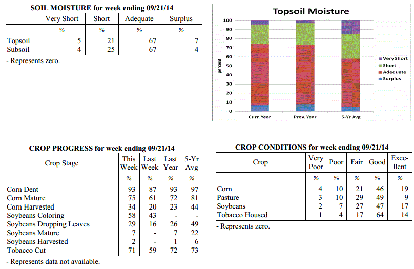
USDA's Kentucky Crop and Weather Report
Issued 4:00 P.M., September 22, 2014, 25-14
Agricultural News: Kentucky experienced mostly dry and cool conditions over the past
week. Precipitation for the week totaled 0.12 inches, 0.71 inches below normal.
Temperatures averaged 66 degrees for the week, 2 degrees below normal. Topsoil
moisture was rated 5 percent very short, 21 percent short, 67 percent adequate and 7
percent surplus. Subsoil moisture was rated 4 percent very short, 25 percent short,
67 percent adequate, and 4 percent surplus. Days suitable for fieldwork averaged 6.3
out of a possible seven.
Dry conditions have returned to the Bluegrass state. Dry weather is negatively
impacting pastures and double crop soybeans in some areas. Diseases such as sudden
death syndrome, frogeye leaf spot and root rot have been reported in soybeans.
Primary activities this week included harvesting corn and hay as well as cutting and
housing tobacco. Labor shortage remains a concern for many tobacco growers. Harvest
of early soybeans is just getting underway.
Kentucky Climate Summary
For the Period September 22, 2014 to September 28, 2014
Below Normal Temperatures and Rainfall:
The start of the autumn season opened with dry and cool conditions in place. Surface
high pressure of Canadian origin built into the Ohio Valley to start the work week.
Highs on Monday only rose into the upper 60s to low 70s, but the more noticeable
difference came later that night. Under clear skies, temperatures plummeted into the
low to mid 40s for most of the state. Some low lying and sheltered locations were able
to drop into the upper 30s, which was around 15 degrees below normal for this time of
the year. A warming trend then ensued for much of the remainder of the week,
eventually returning to near normal by the end. The Commonwealth remained under the
influence of high pressure with mostly clear skies and a light northeast wind about
each day. Other than a few isolated showers across the eastern half of Kentucky on
Sunday, most of the region was left completely dry for the week. This was the second
straight period of much below normal rainfall, but this is fairly common as the state
heads into what is normally the driest time of the year.
Temperatures for the period averaged 64 degrees across the state which was 2 degrees
cooler than normal and no change to the previous period. High temperatures averaged
from 81 in the West to 75 in the East. Departure from normal high temperatures
ranged from 2 degrees warmer than normal in the West to 2 degrees cooler than normal
in the East. Low temperatures averaged from 51 degrees in the West to 51 degrees in
the East. Departure from normal low temperature ranged from 4 degrees cooler than
normal in the West to 1 degree cooler than normal in the East. The extreme high
temperature for the period was 87 degrees at MAYFIELD 6SW and the extreme low was
37 degrees at CADIZ 4SW.
Precipitation (liq. equ.) for the period totaled 0.00 inches statewide which was 0.85
inches below normal and 0% of normal. Precipitation totals by climate division, West
0.00 inches, Central 0.00 inches, Bluegrass 0.00 inches and East 0.00 inches, which
was 0.86, 0.93, 0.77 and 0.84 inches below normal. By station, precipitation totals
ranged from a low of 0.00 inches at ALBANY 1N to a high of 0.06 inches at PADUCAH ASOS.
---
USDA's Kentucky Crop and Weather Report
Issued 4:00 P.M., September 22, 2014, 25-14
Agricultural News: Kentucky experienced mostly dry and cool conditions over the past
week. Precipitation for the week totaled 0.12 inches, 0.71 inches below normal.
Temperatures averaged 66 degrees for the week, 2 degrees below normal. Topsoil
moisture was rated 5 percent very short, 21 percent short, 67 percent adequate and 7
percent surplus. Subsoil moisture was rated 4 percent very short, 25 percent short,
67 percent adequate, and 4 percent surplus. Days suitable for fieldwork averaged 6.3
out of a possible seven.
Dry conditions have returned to the Bluegrass state. Dry weather is negatively
impacting pastures and double crop soybeans in some areas. Diseases such as sudden
death syndrome, frogeye leaf spot and root rot have been reported in soybeans.
Primary activities this week included harvesting corn and hay as well as cutting and
housing tobacco. Labor shortage remains a concern for many tobacco growers. Harvest
of early soybeans is just getting underway.
 Kentucky Climate Summary
For the Period September 15, 2014 to September 21, 2014
Below Normal Temperatures and Rainfall:
Mostly dry and cool conditions took grasp of the Bluegrass State this past period.
Surface high pressure was in control for much of the week with the exception of
couple days on Monday and Sunday. Saying this, each day only featured light showers.
The first event was primarily focused to the eastern half of the state with most
locations picking up less than a quarter inch. The frontal passage on Sunday was a
bit weaker as Western and Southeastern Kentucky each picked up less than a tenth of
an inch on average. Looking at temperatures, much of the period featured highs only
rising into the 60s and 70s. The only day when temperatures were near to above normal
was on Saturday as southwesterly flow guided the mercury into the low to mid 80s.
Temperatures for the period averaged 66 degrees across the state which was 2 degrees
cooler than normal and no change to the previous period. High temperatures averaged
from 77 in the West to 75 in the East. Departure from normal high temperatures
ranged from 5 degrees cooler than normal in the West to 5 degrees cooler than normal
in the East. Low temperatures averaged from 55 degrees in the West to 56 degrees in
the East. Departure from normal low temperature ranged from 3 degrees cooler than
normal in the West to 1 degree warmer than normal in the East. The extreme high
temperature for the period was 90 degrees at PADUCAH ASOS and the extreme low was 42
degrees at HENDERSON 5E.
Precipitation (liq. equ.) for the period totaled 0.12 inches statewide which was 0.71
inches below normal and 14% of normal. Precipitation totals by climate division, West
0.14 inches, Central 0.06 inches, Bluegrass 0.14 inches and East 0.12 inches, which
was 0.71, 0.85, 0.6 and 0.7 inches below normal. By station, precipitation totals
ranged from a low of 0.00 inches at CAMPBELLSVILLE 7W to a high of 0.97
inches at HENDERSON 5E.
---
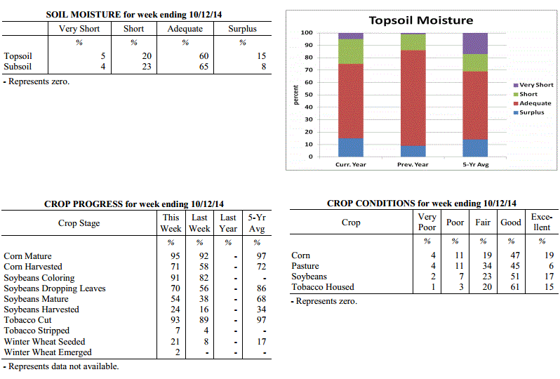
USDA's Kentucky Crop and Weather Report
Issued 4:00 P.M., September 15, 2014, 24-14
Agricultural News: Kentucky experienced below normal temperatures and above normal
rainfall over the past week. Precipitation for the week totaled 0.99 inches, 0.15
inches above normal. Temperatures averaged 68 degrees for the week, 3 degrees below
normal. Topsoil moisture was rated 5 percent very short, 16 percent short, 72 percent
adequate and 7 percent surplus. Subsoil moisture was rated 4 percent very short, 24
percent short, 68 percent adequate, and 4 percent surplus. Days suitable for
fieldwork averaged 5.5 out of a possible seven.
Primary activities this week included cutting and housing tobacco and harvesting
corn. However, recent rainfall has caused corn moisture to be high and harvesting to
proceed slowly. Pastures remain in good condition. Some farmers have reported difficulty
in harvesting tobacco due to labor shortages.
Kentucky Climate Summary
For the Period September 15, 2014 to September 21, 2014
Below Normal Temperatures and Rainfall:
Mostly dry and cool conditions took grasp of the Bluegrass State this past period.
Surface high pressure was in control for much of the week with the exception of
couple days on Monday and Sunday. Saying this, each day only featured light showers.
The first event was primarily focused to the eastern half of the state with most
locations picking up less than a quarter inch. The frontal passage on Sunday was a
bit weaker as Western and Southeastern Kentucky each picked up less than a tenth of
an inch on average. Looking at temperatures, much of the period featured highs only
rising into the 60s and 70s. The only day when temperatures were near to above normal
was on Saturday as southwesterly flow guided the mercury into the low to mid 80s.
Temperatures for the period averaged 66 degrees across the state which was 2 degrees
cooler than normal and no change to the previous period. High temperatures averaged
from 77 in the West to 75 in the East. Departure from normal high temperatures
ranged from 5 degrees cooler than normal in the West to 5 degrees cooler than normal
in the East. Low temperatures averaged from 55 degrees in the West to 56 degrees in
the East. Departure from normal low temperature ranged from 3 degrees cooler than
normal in the West to 1 degree warmer than normal in the East. The extreme high
temperature for the period was 90 degrees at PADUCAH ASOS and the extreme low was 42
degrees at HENDERSON 5E.
Precipitation (liq. equ.) for the period totaled 0.12 inches statewide which was 0.71
inches below normal and 14% of normal. Precipitation totals by climate division, West
0.14 inches, Central 0.06 inches, Bluegrass 0.14 inches and East 0.12 inches, which
was 0.71, 0.85, 0.6 and 0.7 inches below normal. By station, precipitation totals
ranged from a low of 0.00 inches at CAMPBELLSVILLE 7W to a high of 0.97
inches at HENDERSON 5E.
---
USDA's Kentucky Crop and Weather Report
Issued 4:00 P.M., September 15, 2014, 24-14
Agricultural News: Kentucky experienced below normal temperatures and above normal
rainfall over the past week. Precipitation for the week totaled 0.99 inches, 0.15
inches above normal. Temperatures averaged 68 degrees for the week, 3 degrees below
normal. Topsoil moisture was rated 5 percent very short, 16 percent short, 72 percent
adequate and 7 percent surplus. Subsoil moisture was rated 4 percent very short, 24
percent short, 68 percent adequate, and 4 percent surplus. Days suitable for
fieldwork averaged 5.5 out of a possible seven.
Primary activities this week included cutting and housing tobacco and harvesting
corn. However, recent rainfall has caused corn moisture to be high and harvesting to
proceed slowly. Pastures remain in good condition. Some farmers have reported difficulty
in harvesting tobacco due to labor shortages.
 Kentucky Climate Summary
For the Period September 8, 2014 to September 14, 2014
Below Normal Temperatures and Above Normal Rainfall:
Fall-like conditions returned to the Ohio Valley this past period, but not before a
mild, first half of the work week. Highs typically rose into the low to mid 80s each
day with humid conditions remaining in place. The welcoming change came Wednesday
night and into Thursday as a cold front pushed through Ohio Valley. This boundary
sparked widespread showers across the region and while severe weather was absent, a
moist air mass allowed for moderate to heavy rainfall at times. The most significant
totals came across North-Central Kentucky and into the Bluegrass with many locations
picking up between 1.5 to around 3 inches. Lexington, Louisville, and Frankfort all
saw record daily rainfall with more than 2.5 inches at each location. Behind the
front, overcast skies kept temperatures on the cool side Friday and Saturday as highs
only rose into the mid to upper 60s for much of the state. Cloud cover then began to
taper later Saturday as surface high pressure moved into the region. Clear skies
Saturday night allowed for a very cool overnight period as the mercury dipped into
the 40s across the Commonwealth.
Temperatures for the period averaged 68 degrees across the state which was 3 degrees
cooler than normal and 8 degrees cooler than the previous period. High temperatures
averaged from 76 in the West to 76 in the East. Departure from normal high
temperatures ranged from 8 degrees cooler than normal in the West to 6 degrees cooler
than normal in the East. Low temperatures averaged from 58 degrees in the West to 61
degrees in the East. Departure from normal low temperature ranged from 3 degrees
cooler than normal in the West to 3 degrees warmer than normal in the East. The
extreme high temperature for the period was 92 degrees at POPLAR BLUFF ASOS and the
extreme low was 41 degrees at CYNTHIANA 8N.
Precipitation (liq. equ.) for the period totaled 0.99 inches statewide which was 0.15
inches above normal and 119% of normal. Precipitation totals by climate division,
West 0.82 inches, Central 0.47 inches, Bluegrass 1.70 inches and East 0.96 inches,
which was -0.02, -0.46, 0.94 and 0.15 inches respectively from normal. By station,
precipitation totals ranged from a low of 0.00 inches at BOWLING GREEN 4E to a high
of 3.85 inches at FRANKFORT 7S.
---
USDA's Kentucky Crop and Weather Report
Issued 4:00 P.M., September 8, 2014, 23-14
Agricultural News: Kentucky experienced above normal temperatures and slightly below
normal rainfall over the past week. Precipitation for the week totaled 0.72 inches,
0.05 inches below normal. Temperatures averaged 76 degrees for the week, 3 degrees
above normal. Topsoil moisture was rated 5 percent very short, 20 percent short, 66
percent adequate and 9 percent surplus. Subsoil moisture was rated 4 percent very
short, 26 percent short, 64 percent adequate, and 6 percent surplus. Days suitable
for fieldwork averaged 5.4 out of a possible seven.
Primary activities this week included harvesting hay and tobacco, chopping silage and
harvesting corn for grain. There were reports of army worms in pastures and hay
fields in western Kentucky. Hay harvesting has been slowed due to above normal
rainfall in eastern Kentucky. Pasture conditions continue to improve. Livestock are
in mostly good to excellent condition and are benefitting from recent rains.
Kentucky Climate Summary
For the Period September 8, 2014 to September 14, 2014
Below Normal Temperatures and Above Normal Rainfall:
Fall-like conditions returned to the Ohio Valley this past period, but not before a
mild, first half of the work week. Highs typically rose into the low to mid 80s each
day with humid conditions remaining in place. The welcoming change came Wednesday
night and into Thursday as a cold front pushed through Ohio Valley. This boundary
sparked widespread showers across the region and while severe weather was absent, a
moist air mass allowed for moderate to heavy rainfall at times. The most significant
totals came across North-Central Kentucky and into the Bluegrass with many locations
picking up between 1.5 to around 3 inches. Lexington, Louisville, and Frankfort all
saw record daily rainfall with more than 2.5 inches at each location. Behind the
front, overcast skies kept temperatures on the cool side Friday and Saturday as highs
only rose into the mid to upper 60s for much of the state. Cloud cover then began to
taper later Saturday as surface high pressure moved into the region. Clear skies
Saturday night allowed for a very cool overnight period as the mercury dipped into
the 40s across the Commonwealth.
Temperatures for the period averaged 68 degrees across the state which was 3 degrees
cooler than normal and 8 degrees cooler than the previous period. High temperatures
averaged from 76 in the West to 76 in the East. Departure from normal high
temperatures ranged from 8 degrees cooler than normal in the West to 6 degrees cooler
than normal in the East. Low temperatures averaged from 58 degrees in the West to 61
degrees in the East. Departure from normal low temperature ranged from 3 degrees
cooler than normal in the West to 3 degrees warmer than normal in the East. The
extreme high temperature for the period was 92 degrees at POPLAR BLUFF ASOS and the
extreme low was 41 degrees at CYNTHIANA 8N.
Precipitation (liq. equ.) for the period totaled 0.99 inches statewide which was 0.15
inches above normal and 119% of normal. Precipitation totals by climate division,
West 0.82 inches, Central 0.47 inches, Bluegrass 1.70 inches and East 0.96 inches,
which was -0.02, -0.46, 0.94 and 0.15 inches respectively from normal. By station,
precipitation totals ranged from a low of 0.00 inches at BOWLING GREEN 4E to a high
of 3.85 inches at FRANKFORT 7S.
---
USDA's Kentucky Crop and Weather Report
Issued 4:00 P.M., September 8, 2014, 23-14
Agricultural News: Kentucky experienced above normal temperatures and slightly below
normal rainfall over the past week. Precipitation for the week totaled 0.72 inches,
0.05 inches below normal. Temperatures averaged 76 degrees for the week, 3 degrees
above normal. Topsoil moisture was rated 5 percent very short, 20 percent short, 66
percent adequate and 9 percent surplus. Subsoil moisture was rated 4 percent very
short, 26 percent short, 64 percent adequate, and 6 percent surplus. Days suitable
for fieldwork averaged 5.4 out of a possible seven.
Primary activities this week included harvesting hay and tobacco, chopping silage and
harvesting corn for grain. There were reports of army worms in pastures and hay
fields in western Kentucky. Hay harvesting has been slowed due to above normal
rainfall in eastern Kentucky. Pasture conditions continue to improve. Livestock are
in mostly good to excellent condition and are benefitting from recent rains.
 Kentucky Climate Summary
For the Period September 1, 2014 to September 7, 2014
Above Normal Temperatures and Below Normal Rainfall:
Depending on location, the first week of September kept portions of the Commonwealth
wet or dry. Attention surrounded two cold fronts that pushed through the region, one
on Tuesday and the other on Saturday. Each boundary sparked scattered to numerous,
showers and storms across mainly the eastern half of the state. In doing so, while
Eastern Kentucky saw above normal rainfall by nearly a half inch, the western half of
the state was just the opposite, only averaging a third of an inch for the week. The
dry conditions across Western Kentucky were compounded by above normal temperatures
for a third straight week. The highest temperatures were recorded on Thursday and
Friday as the mercury lifted into the upper 80s to low 90s for most. Saying this,
the Bluegrass State finally got some relief on Sunday as cool and dry conditions
moved in behind the cold front. This gave the Commonwealth a first look at fall with
highs only rising into the mid 70s to low 80s and much less humid conditions.
Temperatures for the period averaged 76 degrees across the state which was 3 degrees
warmer than normal and 2 degrees cooler than the previous period. High temperatures
averaged from 86 in the West to 83 in the East. Departure from normal high
temperatures ranged from near normal in the West to 1 degree cooler than
normal in the East. Low temperatures averaged from 69 degrees in the West to 68
degrees in the East. Departure from normal low temperature ranged from 6 degrees
warmer than normal in the West to 8 degrees warmer than normal in the East. The
extreme high temperature for the period was 95 degrees at PADUCAH ASOS and the
extreme low was 53 degrees at CARBONDALE ASOS.
Precipitation (liq. equ.) for the period totaled 0.72 inches statewide which was 0.05
inches below normal and 94% of normal. Precipitation totals by climate division, West
0.35 inches, Central 0.49 inches, Bluegrass 0.76 inches and East 1.28 inches, which
was -0.36, -0.35, 0.03 and 0.49 inches respectively from normal. By station,
precipitation totals ranged from a low of 0.00 inches at CALHOUN 5NW to a high of
2.35 inches at YELLOW CREEK.
---
USDA's Kentucky Crop and Weather Report
Issued 4:00 P.M., September 2, 2014, 22-14
Agricultural News: Kentucky experienced above normal temperatures and rainfall over
the past week. Precipitation for the week totaled 1.25 inches, 0.50 inches above
normal. Temperatures averaged 78 degrees for the week, 4 degrees above normal.
Topsoil moisture was rated 7 percent very short, 22 percent short, 62 percent
adequate and 9 percent surplus. Subsoil moisture was rated 6 percent very short, 28
percent short, 61 percent adequate, and 5 percent surplus. Days suitable for
fieldwork averaged 5.5 out of a possible seven.
Primary activities this week included harvesting and baling hay and topping and
cutting tobacco. Pasture conditions continued to improve with wide coverage of
rainfall throughout the state. However, rainfall has been causing delays to late hay
harvest and cutting tobacco. Corn harvest has begun, mostly for silage to date.
However, some early corn for grain in western Kentucky has also been harvested. With
continued warm weather, farmers are expecting the corn harvest to become widespread
in the coming weeks.
Kentucky Climate Summary
For the Period September 1, 2014 to September 7, 2014
Above Normal Temperatures and Below Normal Rainfall:
Depending on location, the first week of September kept portions of the Commonwealth
wet or dry. Attention surrounded two cold fronts that pushed through the region, one
on Tuesday and the other on Saturday. Each boundary sparked scattered to numerous,
showers and storms across mainly the eastern half of the state. In doing so, while
Eastern Kentucky saw above normal rainfall by nearly a half inch, the western half of
the state was just the opposite, only averaging a third of an inch for the week. The
dry conditions across Western Kentucky were compounded by above normal temperatures
for a third straight week. The highest temperatures were recorded on Thursday and
Friday as the mercury lifted into the upper 80s to low 90s for most. Saying this,
the Bluegrass State finally got some relief on Sunday as cool and dry conditions
moved in behind the cold front. This gave the Commonwealth a first look at fall with
highs only rising into the mid 70s to low 80s and much less humid conditions.
Temperatures for the period averaged 76 degrees across the state which was 3 degrees
warmer than normal and 2 degrees cooler than the previous period. High temperatures
averaged from 86 in the West to 83 in the East. Departure from normal high
temperatures ranged from near normal in the West to 1 degree cooler than
normal in the East. Low temperatures averaged from 69 degrees in the West to 68
degrees in the East. Departure from normal low temperature ranged from 6 degrees
warmer than normal in the West to 8 degrees warmer than normal in the East. The
extreme high temperature for the period was 95 degrees at PADUCAH ASOS and the
extreme low was 53 degrees at CARBONDALE ASOS.
Precipitation (liq. equ.) for the period totaled 0.72 inches statewide which was 0.05
inches below normal and 94% of normal. Precipitation totals by climate division, West
0.35 inches, Central 0.49 inches, Bluegrass 0.76 inches and East 1.28 inches, which
was -0.36, -0.35, 0.03 and 0.49 inches respectively from normal. By station,
precipitation totals ranged from a low of 0.00 inches at CALHOUN 5NW to a high of
2.35 inches at YELLOW CREEK.
---
USDA's Kentucky Crop and Weather Report
Issued 4:00 P.M., September 2, 2014, 22-14
Agricultural News: Kentucky experienced above normal temperatures and rainfall over
the past week. Precipitation for the week totaled 1.25 inches, 0.50 inches above
normal. Temperatures averaged 78 degrees for the week, 4 degrees above normal.
Topsoil moisture was rated 7 percent very short, 22 percent short, 62 percent
adequate and 9 percent surplus. Subsoil moisture was rated 6 percent very short, 28
percent short, 61 percent adequate, and 5 percent surplus. Days suitable for
fieldwork averaged 5.5 out of a possible seven.
Primary activities this week included harvesting and baling hay and topping and
cutting tobacco. Pasture conditions continued to improve with wide coverage of
rainfall throughout the state. However, rainfall has been causing delays to late hay
harvest and cutting tobacco. Corn harvest has begun, mostly for silage to date.
However, some early corn for grain in western Kentucky has also been harvested. With
continued warm weather, farmers are expecting the corn harvest to become widespread
in the coming weeks.
 Kentucky Climate Summary
For the Period August 25, 2014 to August 31, 2014
Above Normal Temperatures and Rainfall:
Hot, humid, and wet conditions persisted across the Commonwealth for a second
straight week. An upper level ridge of high pressure was situated over the area for
the first half of the work week. This extended an already drawn-out heat wave from
the previous period. Highs repeatedly pushed into the upper 80s to middle 90s each
day. Accompanied by dewpoints in the 70s, the livestock heat stress index hovered in
the danger to emergency category each afternoon and evening. Focus then turned
toward a very active second half of the week. Isolated to scattered storms fired on
a daily basis between Wednesday and Friday as a frontal boundary meandered across the
state and combined with a moist and unstable air mass. The unsettled pattern then
continued into the holiday weekend as the Ohio Valley was placed in a southwesterly
flow pattern. Scattered to numerous showers and storms developed within this regime
as deep gulf moisture pushed into the region. Over the course of the week, the
state averaged 1.25 inches, which pushed Kentucky to a fourth straight week of above
normal rainfall.
Temperatures for the period averaged 78 degrees across the state which was 4 degrees
warmer than normal and no change to the previous period. High temperatures averaged
from 89 in the West to 85 in the East. Departure from normal high temperatures
ranged from 1 degree warmer than normal in the West to near normal in the East. Low
temperatures averaged from 70 degrees in the West to 66 degrees in the East. Departure
from normal low temperature ranged from 6 degrees warmer than normal in the West to 5
degrees warmer than normal in the East. The extreme high temperature for the period
was 98 degrees at MAYFIELD 6SW and the extreme low was 57 degrees at BLACK MOUNTAIN ARC.
Precipitation (liq. equ.) for the period totaled 1.25 inches statewide which was 0.50
inches above normal and 168% of normal. Precipitation totals by climate division,
West 1.51 inches, Central 1.50 inches, Bluegrass 0.62 inches and East 1.39 inches,
which was 0.84, 0.72, -0.12 and 0.60 inches respectively from normal. By station,
precipitation totals ranged from a low of 0.12 inches at SHELBYVILLE 10W to a high of
4.72 inches at PADUCAH ASOS.
---
USDA's Kentucky Crop and Weather Report
Issued 4:00 P.M., August 25, 2014, 21-14
Agricultural News: Kentucky experienced above normal temperatures and rainfall over
the past week. Precipitation for the week totaled 1.85 inches, 1.01 inches above
normal. Temperatures averaged 78 degrees for the week, 3 degrees above normal.
Topsoil moisture was rated 9 percent very short, 25 percent short, 58 percent
adequate and 8 percent surplus. Subsoil moisture was rated 9 percent very short, 32
percent short, 54 percent adequate, and 5 percent surplus. Days suitable for
fieldwork averaged 5.1 out of a possible seven.
Primary activities this week included harvesting hay and topping and cutting tobacco.
Scattered rainfall received last week was beneficial to most all crops. Some
locations continued to report dry conditions. Producers remain concerned that late
planted double crop soybeans may be in danger if there is an early frost. High
temperatures and humidity created heat stress conditions for livestock. Recent
precipitation has slightly improved hay and pasture conditions.
Kentucky Climate Summary
For the Period August 25, 2014 to August 31, 2014
Above Normal Temperatures and Rainfall:
Hot, humid, and wet conditions persisted across the Commonwealth for a second
straight week. An upper level ridge of high pressure was situated over the area for
the first half of the work week. This extended an already drawn-out heat wave from
the previous period. Highs repeatedly pushed into the upper 80s to middle 90s each
day. Accompanied by dewpoints in the 70s, the livestock heat stress index hovered in
the danger to emergency category each afternoon and evening. Focus then turned
toward a very active second half of the week. Isolated to scattered storms fired on
a daily basis between Wednesday and Friday as a frontal boundary meandered across the
state and combined with a moist and unstable air mass. The unsettled pattern then
continued into the holiday weekend as the Ohio Valley was placed in a southwesterly
flow pattern. Scattered to numerous showers and storms developed within this regime
as deep gulf moisture pushed into the region. Over the course of the week, the
state averaged 1.25 inches, which pushed Kentucky to a fourth straight week of above
normal rainfall.
Temperatures for the period averaged 78 degrees across the state which was 4 degrees
warmer than normal and no change to the previous period. High temperatures averaged
from 89 in the West to 85 in the East. Departure from normal high temperatures
ranged from 1 degree warmer than normal in the West to near normal in the East. Low
temperatures averaged from 70 degrees in the West to 66 degrees in the East. Departure
from normal low temperature ranged from 6 degrees warmer than normal in the West to 5
degrees warmer than normal in the East. The extreme high temperature for the period
was 98 degrees at MAYFIELD 6SW and the extreme low was 57 degrees at BLACK MOUNTAIN ARC.
Precipitation (liq. equ.) for the period totaled 1.25 inches statewide which was 0.50
inches above normal and 168% of normal. Precipitation totals by climate division,
West 1.51 inches, Central 1.50 inches, Bluegrass 0.62 inches and East 1.39 inches,
which was 0.84, 0.72, -0.12 and 0.60 inches respectively from normal. By station,
precipitation totals ranged from a low of 0.12 inches at SHELBYVILLE 10W to a high of
4.72 inches at PADUCAH ASOS.
---
USDA's Kentucky Crop and Weather Report
Issued 4:00 P.M., August 25, 2014, 21-14
Agricultural News: Kentucky experienced above normal temperatures and rainfall over
the past week. Precipitation for the week totaled 1.85 inches, 1.01 inches above
normal. Temperatures averaged 78 degrees for the week, 3 degrees above normal.
Topsoil moisture was rated 9 percent very short, 25 percent short, 58 percent
adequate and 8 percent surplus. Subsoil moisture was rated 9 percent very short, 32
percent short, 54 percent adequate, and 5 percent surplus. Days suitable for
fieldwork averaged 5.1 out of a possible seven.
Primary activities this week included harvesting hay and topping and cutting tobacco.
Scattered rainfall received last week was beneficial to most all crops. Some
locations continued to report dry conditions. Producers remain concerned that late
planted double crop soybeans may be in danger if there is an early frost. High
temperatures and humidity created heat stress conditions for livestock. Recent
precipitation has slightly improved hay and pasture conditions.
 Kentucky Climate Summary
For the Period August 18, 2014 to August 24, 2014
Above Normal Temperatures and Much Above Normal Rainfall:
Intense heat and humid conditions made way back into the Commonwealth this past
period. A upper level ridge of high pressure built into the region on Thursday and
remained through the weekend, making way for the hottest and most humid conditions of
the year. Each day saw highs get into the upper 80s to middle 90s, along with
dewpoints rising into the 70s. The hot and humid conditions prompted a Heat Advisory
to be issued for much of the western half of the state as the heat index topped 100
degrees over multiple days. Conditions pushed the livestock heat stress index into
the danger to emergency category. Accompanying the heat wave was exceptionally
high rainfall totals across much of the state. Scattered showers and storms fired on
a near daily basis. The very moist and unstable air mass allowed for very efficient
rainfall producers and excessive lightning at times. The state averaged nearly 2
inches across the period, which was over an inch above normal. Saying this, the Purchase
was spared and dry conditions continue to deepen.
Temperatures for the period averaged 78 degrees across the state which was 3 degrees
warmer than normal and 6 degrees warmer than the previous period. High temperatures
averaged from 90 in the West to 85 in the East. Departure from normal high
temperatures ranged from 2 degrees warmer than normal in the West to 1 degree
cooler than normal in the East. Low temperatures averaged from 71 degrees in the
West to 68 degrees in the East. Departure from normal low temperature ranged from 6
degrees warmer than normal in the West to 6 degrees warmer than normal in the East.
The extreme high temperature for the period was 98 degrees at MAYFIELD 6SW and the
extreme low was 62 degrees at BLACK MOUNTAIN ARC.
Precipitation (liq. equ.) for the period totaled 1.85 inches statewide which was 1.01
inches above normal and 220% of normal. Precipitation totals by climate division,
West 0.69 inches, Central 2.25 inches, Bluegrass 2.17 inches and East 2.29 inches,
which was -0.07, 1.40, 1.32 and 1.38 inches respectively from normal. By station,
precipitation totals ranged from a low of 0.00 inches at MAYFIELD 6SW to a high of
5.10 inches at OWENTON 5E.
---
USDA's Kentucky Crop and Weather Report
Issued 4:00 P.M., August 18, 2014, 20-14
Agricultural News: Kentucky experienced below normal temperatures and above normal
rainfall over the past week. Precipitation for the week totaled 1.29 inches, 0.43
inches above normal. Temperatures averaged 72 degrees for the week, 4 degrees below
normal. Topsoil moisture was rated 13 percent very short, 30 percent short, 51
percent adequate and 6 percent surplus. Subsoil moisture was rated 12 percent very
short, 35 percent short, 49 percent adequate, and 4 percent surplus. Days suitable
for fieldwork averaged 5.3 out of a possible seven.
Primary activities this week included harvesting hay and topping and cutting tobacco.
Rainfall received last week was beneficial to most all crops. However, depending on
the stage of corn development, rains may be to late to improve conditions. Some
producers are concerned that late planted double crop soybeans may be in danger if
there is an early frost. There were reports of stink bugs active in soybeans. Recent
precipitation has improved hay and pasture conditions.
Kentucky Climate Summary
For the Period August 18, 2014 to August 24, 2014
Above Normal Temperatures and Much Above Normal Rainfall:
Intense heat and humid conditions made way back into the Commonwealth this past
period. A upper level ridge of high pressure built into the region on Thursday and
remained through the weekend, making way for the hottest and most humid conditions of
the year. Each day saw highs get into the upper 80s to middle 90s, along with
dewpoints rising into the 70s. The hot and humid conditions prompted a Heat Advisory
to be issued for much of the western half of the state as the heat index topped 100
degrees over multiple days. Conditions pushed the livestock heat stress index into
the danger to emergency category. Accompanying the heat wave was exceptionally
high rainfall totals across much of the state. Scattered showers and storms fired on
a near daily basis. The very moist and unstable air mass allowed for very efficient
rainfall producers and excessive lightning at times. The state averaged nearly 2
inches across the period, which was over an inch above normal. Saying this, the Purchase
was spared and dry conditions continue to deepen.
Temperatures for the period averaged 78 degrees across the state which was 3 degrees
warmer than normal and 6 degrees warmer than the previous period. High temperatures
averaged from 90 in the West to 85 in the East. Departure from normal high
temperatures ranged from 2 degrees warmer than normal in the West to 1 degree
cooler than normal in the East. Low temperatures averaged from 71 degrees in the
West to 68 degrees in the East. Departure from normal low temperature ranged from 6
degrees warmer than normal in the West to 6 degrees warmer than normal in the East.
The extreme high temperature for the period was 98 degrees at MAYFIELD 6SW and the
extreme low was 62 degrees at BLACK MOUNTAIN ARC.
Precipitation (liq. equ.) for the period totaled 1.85 inches statewide which was 1.01
inches above normal and 220% of normal. Precipitation totals by climate division,
West 0.69 inches, Central 2.25 inches, Bluegrass 2.17 inches and East 2.29 inches,
which was -0.07, 1.40, 1.32 and 1.38 inches respectively from normal. By station,
precipitation totals ranged from a low of 0.00 inches at MAYFIELD 6SW to a high of
5.10 inches at OWENTON 5E.
---
USDA's Kentucky Crop and Weather Report
Issued 4:00 P.M., August 18, 2014, 20-14
Agricultural News: Kentucky experienced below normal temperatures and above normal
rainfall over the past week. Precipitation for the week totaled 1.29 inches, 0.43
inches above normal. Temperatures averaged 72 degrees for the week, 4 degrees below
normal. Topsoil moisture was rated 13 percent very short, 30 percent short, 51
percent adequate and 6 percent surplus. Subsoil moisture was rated 12 percent very
short, 35 percent short, 49 percent adequate, and 4 percent surplus. Days suitable
for fieldwork averaged 5.3 out of a possible seven.
Primary activities this week included harvesting hay and topping and cutting tobacco.
Rainfall received last week was beneficial to most all crops. However, depending on
the stage of corn development, rains may be to late to improve conditions. Some
producers are concerned that late planted double crop soybeans may be in danger if
there is an early frost. There were reports of stink bugs active in soybeans. Recent
precipitation has improved hay and pasture conditions.
 Kentucky Climate Summary
For the Period August 11, 2014 to August 17, 2014
Below Normal Temperatures and Above Normal Rainfall:
The wet and cool pattern continued for the Lower Ohio Valley this past period.
Kentucky saw above normal precipitation for the fourth time over the past five weeks
with a state average over an inch. Most of the rainfall came over the course of two
days. The first event occurred on Monday as a cluster of showers and storms pushed
east across the Commonwealth, followed by a trailing cold front. South-central
portions of Kentucky came out the winners with much of the region picking up over an
inch. The second came over the latter half of the weekend as low pressure slowly
meandered across the Ohio Valley. As was the case with both events, Kentucky was
situated within a very moist air mass, leading to torrential rainfall at times.
Looking at areas suffering from drought stress, most regions saw beneficial rainfall,
with the exception of the Purchase. Following the cold front earlier in the week,
temperatures remained cool for much of the period. High temperatures typically only
rose into the upper 70s to mid 80s, which pushed the state to a seventh straight week
of below normal temperatures.
Temperatures for the period averaged 72 degrees across the state which was 4 degrees
cooler than normal and 2 degrees cooler than the previous period. High temperatures
averaged from 83 in the West to 79 in the East. Departure from normal high
temperatures ranged from 5 degrees cooler than normal in the West to 7 degrees
cooler than normal in the East. Low temperatures averaged from 64 degrees in the
West to 62 degrees in the East. Departure from normal low temperature ranged from 2
degrees cooler than normal in the West to 1 degree cooler than normal in the East.
The extreme high temperature for the period was 91 degrees at POPLAR BLUFF ASOS and
the extreme low was 48 degrees at CYNTHIANA 8N.
Precipitation (liq. equ.) for the period totaled 1.29 inches statewide which was 0.43
inches above normal and 150% of normal. Precipitation totals by climate division,
West 1.48 inches, Central 1.80 inches, Bluegrass 0.95 inches and East 0.91 inches,
which was 0.68, 0.96, 0.08 and -0.03 inches respectively from normal. By station,
precipitation totals ranged from a low of 0.00 inches at POPLAR BLUFF ASOS to a high
of 5.26 inches at GREENVILLE 6N.
---
USDA's Kentucky Crop and Weather Report
Issued 4:00 P.M., August 11, 2014, 19-14
Agricultural News: Kentucky experienced dry conditions early in the week, but parts
of the state received some much needed relief toward the end of the week.
Precipitation for the week totaled 1.33 inches, 0.41 inches above normal.
Temperatures averaged 75 degrees for the week, 1 degrees below normal. Topsoil
moisture was rated 18 percent very short, 38 percent short, 41 percent adequate and 3
percent surplus. Subsoil moisture was rated 14 percent very short, 40 percent short,
43 percent adequate, and 3 percent surplus. Days suitable for fieldwork averaged 5.9
out of a possible seven.
Primary activities this week included the beginning of tobacco harvest and a
continuation of tobacco topping. Rains beginning on Friday were welcomed where
received and should prove beneficial to most crops. However, recent precipitation may
be a little too late for some corn fields depending on the stage of development. Many
cattle herds are on hay, but the rain provided some much needed relief to pastures.
Lack of overall rainfall continues to be a concern for many farmers.
Kentucky Climate Summary
For the Period August 11, 2014 to August 17, 2014
Below Normal Temperatures and Above Normal Rainfall:
The wet and cool pattern continued for the Lower Ohio Valley this past period.
Kentucky saw above normal precipitation for the fourth time over the past five weeks
with a state average over an inch. Most of the rainfall came over the course of two
days. The first event occurred on Monday as a cluster of showers and storms pushed
east across the Commonwealth, followed by a trailing cold front. South-central
portions of Kentucky came out the winners with much of the region picking up over an
inch. The second came over the latter half of the weekend as low pressure slowly
meandered across the Ohio Valley. As was the case with both events, Kentucky was
situated within a very moist air mass, leading to torrential rainfall at times.
Looking at areas suffering from drought stress, most regions saw beneficial rainfall,
with the exception of the Purchase. Following the cold front earlier in the week,
temperatures remained cool for much of the period. High temperatures typically only
rose into the upper 70s to mid 80s, which pushed the state to a seventh straight week
of below normal temperatures.
Temperatures for the period averaged 72 degrees across the state which was 4 degrees
cooler than normal and 2 degrees cooler than the previous period. High temperatures
averaged from 83 in the West to 79 in the East. Departure from normal high
temperatures ranged from 5 degrees cooler than normal in the West to 7 degrees
cooler than normal in the East. Low temperatures averaged from 64 degrees in the
West to 62 degrees in the East. Departure from normal low temperature ranged from 2
degrees cooler than normal in the West to 1 degree cooler than normal in the East.
The extreme high temperature for the period was 91 degrees at POPLAR BLUFF ASOS and
the extreme low was 48 degrees at CYNTHIANA 8N.
Precipitation (liq. equ.) for the period totaled 1.29 inches statewide which was 0.43
inches above normal and 150% of normal. Precipitation totals by climate division,
West 1.48 inches, Central 1.80 inches, Bluegrass 0.95 inches and East 0.91 inches,
which was 0.68, 0.96, 0.08 and -0.03 inches respectively from normal. By station,
precipitation totals ranged from a low of 0.00 inches at POPLAR BLUFF ASOS to a high
of 5.26 inches at GREENVILLE 6N.
---
USDA's Kentucky Crop and Weather Report
Issued 4:00 P.M., August 11, 2014, 19-14
Agricultural News: Kentucky experienced dry conditions early in the week, but parts
of the state received some much needed relief toward the end of the week.
Precipitation for the week totaled 1.33 inches, 0.41 inches above normal.
Temperatures averaged 75 degrees for the week, 1 degrees below normal. Topsoil
moisture was rated 18 percent very short, 38 percent short, 41 percent adequate and 3
percent surplus. Subsoil moisture was rated 14 percent very short, 40 percent short,
43 percent adequate, and 3 percent surplus. Days suitable for fieldwork averaged 5.9
out of a possible seven.
Primary activities this week included the beginning of tobacco harvest and a
continuation of tobacco topping. Rains beginning on Friday were welcomed where
received and should prove beneficial to most crops. However, recent precipitation may
be a little too late for some corn fields depending on the stage of development. Many
cattle herds are on hay, but the rain provided some much needed relief to pastures.
Lack of overall rainfall continues to be a concern for many farmers.
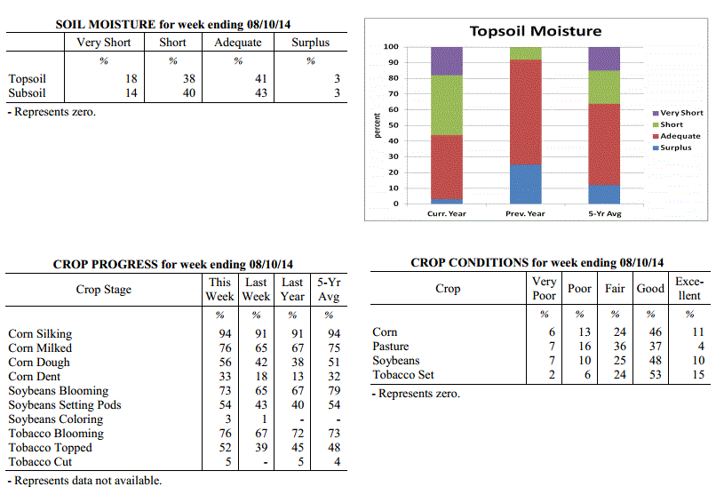 Kentucky Climate Summary
For the Period August 4, 2014 to August 10, 2014
Below Normal Temperatures and Above Normal Rainfall:
Showers and storms pushed into the Bluegrass State this past period and could not have
come at a better time. Leading up to this past Thursday, Kentucky started the week
on a dry note with surface high pressure situated across the region. Combined with
a very dry previous period, the Commonwealth saw moderate drought expand to consume 19%
of the state, mainly across the western half of Kentucky. By Thursday, the pattern
shifted dramatically. A frontal boundary stalled in the vicinity of the Lower Ohio
Valley and remained through the weekend. Most activity remained across Western
Kentucky through the remainder of the work week, before shifting east over the
weekend. Each day featured scattered to numerous showers and thunderstorms. Storms
remained under severe limits, but some were efficient rainfall producers with
torrential rainfall at times. One of the most significant cases was over Lexington
Sunday morning, when over 2 inches was reported in 1 hour. Over the course of the
period, the state was nearly a half inch above normal and temperatures were below
normal for the 6th straight week.
Temperatures for the period averaged 75 degrees across the state which was 1 degree
cooler than normal and 6 degrees warmer than the previous period. High temperatures
averaged from 88 in the West to 81 in the East. Departure from normal high
temperatures ranged from near normal in the West to 5 degrees cooler than
normal in the East. Low temperatures averaged from 67 degrees in the West to 64
degrees in the East. Departure from normal low temperature ranged from 1 degree
warmer than normal in the West to 1 degree warmer than normal in the East. The
extreme high temperature for the period was 95 degrees at FORT CAMPBELL and the
extreme low was 55 degrees at BURKESVILLE 3W.
Precipitation (liq. equ.) for the period totaled 1.33 inches statewide which was 0.41
inches above normal and 144% of normal. Precipitation totals by climate division,
West 1.26 inches, Central 1.37 inches, Bluegrass 1.22 inches and East 1.49 inches,
which was 0.37, 0.47, 0.32 and 0.48 inches above normal. By station, precipitation
totals ranged from a low of 0.01 inches at ALEXANDRIA 5NW to a high of 6.42
inches at LEXINGTON APT.
---
USDA's Kentucky Crop and Weather Report
Issued 4:00 P.M., August 4, 2014, 18-14
Agricultural News: Kentucky experienced unusually cool temperatures and dry
conditions over the past week. Precipitation for the week totaled 0.23 inches, 0.74
inches below normal. Temperatures averaged 70 degrees for the week, 6 degrees below
normal. Topsoil moisture was rated 19 percent very short, 38 percent short, 40
percent adequate and 3 percent surplus. Subsoil moisture was rated 14 percent very
short, 36 percent short, 47 percent adequate, and 3 percent surplus. Days suitable
for fieldwork averaged 6.3 out of a possible seven.
Primary activities this week included harvesting hay, topping tobacco and general
farm maintenance. Lack of rainfall continues to be a concern for many farmers as
moderate drought conditions expanded to more areas of the state. As a result of the
dry weather, crop conditions continue to deteriorate, especially in corn and
soybeans. Early planted crops appear to be fairing better than later planted crops.
Grain crops are reportedly maturing early and lack of adequate rainfall is causing
concern regarding corn kernel fill and soybean pod fill. Some fields of double crop
soybeans are showing severe stand problems and in some instances have yet to
germinate due to a lack of moisture. There were reports of fall armyworms in corn and
stink bugs in soybeans, but not causing major problems at this point. Some livestock
producers are feeding hay, which will cut into their winter supplies. Hay and
roughage supplies were reported as 4 percent very short, 26 percent short, 63 percent
adequate, and 7 percent surplus. The cool temperatures have benefitted livestock.
Kentucky Climate Summary
For the Period August 4, 2014 to August 10, 2014
Below Normal Temperatures and Above Normal Rainfall:
Showers and storms pushed into the Bluegrass State this past period and could not have
come at a better time. Leading up to this past Thursday, Kentucky started the week
on a dry note with surface high pressure situated across the region. Combined with
a very dry previous period, the Commonwealth saw moderate drought expand to consume 19%
of the state, mainly across the western half of Kentucky. By Thursday, the pattern
shifted dramatically. A frontal boundary stalled in the vicinity of the Lower Ohio
Valley and remained through the weekend. Most activity remained across Western
Kentucky through the remainder of the work week, before shifting east over the
weekend. Each day featured scattered to numerous showers and thunderstorms. Storms
remained under severe limits, but some were efficient rainfall producers with
torrential rainfall at times. One of the most significant cases was over Lexington
Sunday morning, when over 2 inches was reported in 1 hour. Over the course of the
period, the state was nearly a half inch above normal and temperatures were below
normal for the 6th straight week.
Temperatures for the period averaged 75 degrees across the state which was 1 degree
cooler than normal and 6 degrees warmer than the previous period. High temperatures
averaged from 88 in the West to 81 in the East. Departure from normal high
temperatures ranged from near normal in the West to 5 degrees cooler than
normal in the East. Low temperatures averaged from 67 degrees in the West to 64
degrees in the East. Departure from normal low temperature ranged from 1 degree
warmer than normal in the West to 1 degree warmer than normal in the East. The
extreme high temperature for the period was 95 degrees at FORT CAMPBELL and the
extreme low was 55 degrees at BURKESVILLE 3W.
Precipitation (liq. equ.) for the period totaled 1.33 inches statewide which was 0.41
inches above normal and 144% of normal. Precipitation totals by climate division,
West 1.26 inches, Central 1.37 inches, Bluegrass 1.22 inches and East 1.49 inches,
which was 0.37, 0.47, 0.32 and 0.48 inches above normal. By station, precipitation
totals ranged from a low of 0.01 inches at ALEXANDRIA 5NW to a high of 6.42
inches at LEXINGTON APT.
---
USDA's Kentucky Crop and Weather Report
Issued 4:00 P.M., August 4, 2014, 18-14
Agricultural News: Kentucky experienced unusually cool temperatures and dry
conditions over the past week. Precipitation for the week totaled 0.23 inches, 0.74
inches below normal. Temperatures averaged 70 degrees for the week, 6 degrees below
normal. Topsoil moisture was rated 19 percent very short, 38 percent short, 40
percent adequate and 3 percent surplus. Subsoil moisture was rated 14 percent very
short, 36 percent short, 47 percent adequate, and 3 percent surplus. Days suitable
for fieldwork averaged 6.3 out of a possible seven.
Primary activities this week included harvesting hay, topping tobacco and general
farm maintenance. Lack of rainfall continues to be a concern for many farmers as
moderate drought conditions expanded to more areas of the state. As a result of the
dry weather, crop conditions continue to deteriorate, especially in corn and
soybeans. Early planted crops appear to be fairing better than later planted crops.
Grain crops are reportedly maturing early and lack of adequate rainfall is causing
concern regarding corn kernel fill and soybean pod fill. Some fields of double crop
soybeans are showing severe stand problems and in some instances have yet to
germinate due to a lack of moisture. There were reports of fall armyworms in corn and
stink bugs in soybeans, but not causing major problems at this point. Some livestock
producers are feeding hay, which will cut into their winter supplies. Hay and
roughage supplies were reported as 4 percent very short, 26 percent short, 63 percent
adequate, and 7 percent surplus. The cool temperatures have benefitted livestock.
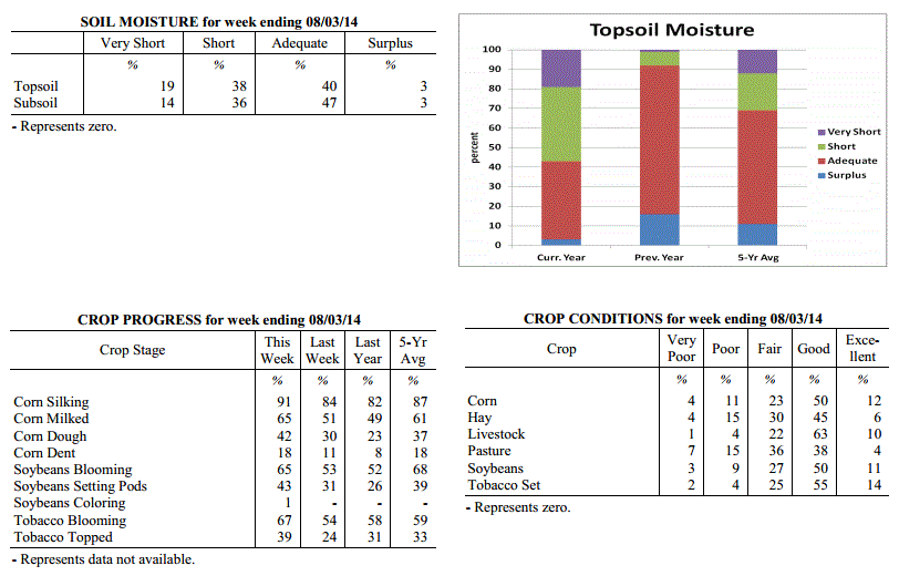 Kentucky Climate Summary
For the Period July 28, 2014 to August 3, 2014
Below Normal Temperatures and Rainfall:
The unusual pattern of cool temperatures and dry conditions continued through the end
of July and early August. Normally one of the warmest times of the year, each day
this week saw below normal temperatures, both during the day and at night. The
coolest temperatures were felt early in the work week as Kentucky was under the
influence of a Canadian air mass and northwesterly flow. Most locations only rose
into the 70s Monday through Wednesday. Some locations even broke record lows on
Monday night. A handful of stations dropped into the upper 40s, which is around 20
degrees below normal for this time of the year. The cool pattern led to the fifth
straight week of near to below normal temperatures. Looking at rainfall, it was
another dry week across the Commonwealth. The only significant activity was Saturday
when showers and storms were isolated to scattered in coverage. The state as a whole
averaged under a quarter inch for the week, but the majority came across the eastern
half of the state. Western Kentucky was once again spared and resulted in Moderate
Drought being introduced to a large section of West-Central Kentucky by the US
Drought Monitor. This was the seventh straight week Western Kentucky has seen below
normal precipitation.
Temperatures for the period averaged 70 degrees across the state which was 6 degrees
cooler than normal and 4 degrees cooler than the previous period. High temperatures
averaged from 83 in the West to 78 in the East. Departure from normal high
temperatures ranged from 6 degrees cooler than normal in the West to 9 degrees
cooler than normal in the East. Low temperatures averaged from 59 degrees in the
West to 59 degrees in the East. Departure from normal low temperature ranged from 8
degrees cooler than normal in the West to 5 degrees cooler than normal in the East.
The extreme high temperature for the period was 92 degrees at BOWLING GREEN 4E and
the extreme low was 48 degrees at BLACK MOUNTAIN ARC.
Precipitation (liq. equ.) for the period totaled 0.23 inches statewide which was 0.74
inches below normal and 24% of normal. Precipitation totals by climate division, West
0.07 inches, Central 0.08 inches, Bluegrass 0.23 inches and East 0.55 inches, which
was 0.86, 0.88, 0.73 and 0.49 inches below normal. By station, precipitation totals
ranged from a low of 0.00 inches at BENTON 4N to a high of 2.04 inches at PAINTSVILLE 4W.
---
USDA's Kentucky Crop and Weather Report
Issued 4:00 P.M., July 28, 2014, 17-14
Agricultural News: Kentucky experienced a mix of heat, severe weather, and cool
conditions over the past week. Precipitation for the week totaled 1.17 inches, 0.21
inches above normal. Temperatures averaged 75 degrees for the week, 2 degrees below
normal. Topsoil moisture was rated 15 percent very short, 36 percent short, 44
percent adequate and 5 percent surplus. Subsoil moisture was rated 12 percent very
short, 32 percent short, 51 percent adequate, and 5 percent surplus. Days suitable
for fieldwork averaged 5.9 out of a possible seven.
Primary activities this week included spraying soybeans, baling hay, topping tobacco,
and general farm maintenance. Rains continue to be scattered, providing improvement
in pasture and crop conditions in some areas. However, dry conditions have continued
throughout other areas of the state and pasture and crop conditions continue to
deteriorate. There were some reports of corn twisting due to lack of adequate
rainfall. High winds resulted in corn and tobacco being blown over in a few
locations. Some farmers reported soybeans are wilting in the afternoons and a few are
replanting double crop soybeans. Pastures continue to deteriorate in areas and more
farmers are beginning to feed hay. There were a few reports of disease issues in vegetables.
Kentucky Climate Summary
For the Period July 28, 2014 to August 3, 2014
Below Normal Temperatures and Rainfall:
The unusual pattern of cool temperatures and dry conditions continued through the end
of July and early August. Normally one of the warmest times of the year, each day
this week saw below normal temperatures, both during the day and at night. The
coolest temperatures were felt early in the work week as Kentucky was under the
influence of a Canadian air mass and northwesterly flow. Most locations only rose
into the 70s Monday through Wednesday. Some locations even broke record lows on
Monday night. A handful of stations dropped into the upper 40s, which is around 20
degrees below normal for this time of the year. The cool pattern led to the fifth
straight week of near to below normal temperatures. Looking at rainfall, it was
another dry week across the Commonwealth. The only significant activity was Saturday
when showers and storms were isolated to scattered in coverage. The state as a whole
averaged under a quarter inch for the week, but the majority came across the eastern
half of the state. Western Kentucky was once again spared and resulted in Moderate
Drought being introduced to a large section of West-Central Kentucky by the US
Drought Monitor. This was the seventh straight week Western Kentucky has seen below
normal precipitation.
Temperatures for the period averaged 70 degrees across the state which was 6 degrees
cooler than normal and 4 degrees cooler than the previous period. High temperatures
averaged from 83 in the West to 78 in the East. Departure from normal high
temperatures ranged from 6 degrees cooler than normal in the West to 9 degrees
cooler than normal in the East. Low temperatures averaged from 59 degrees in the
West to 59 degrees in the East. Departure from normal low temperature ranged from 8
degrees cooler than normal in the West to 5 degrees cooler than normal in the East.
The extreme high temperature for the period was 92 degrees at BOWLING GREEN 4E and
the extreme low was 48 degrees at BLACK MOUNTAIN ARC.
Precipitation (liq. equ.) for the period totaled 0.23 inches statewide which was 0.74
inches below normal and 24% of normal. Precipitation totals by climate division, West
0.07 inches, Central 0.08 inches, Bluegrass 0.23 inches and East 0.55 inches, which
was 0.86, 0.88, 0.73 and 0.49 inches below normal. By station, precipitation totals
ranged from a low of 0.00 inches at BENTON 4N to a high of 2.04 inches at PAINTSVILLE 4W.
---
USDA's Kentucky Crop and Weather Report
Issued 4:00 P.M., July 28, 2014, 17-14
Agricultural News: Kentucky experienced a mix of heat, severe weather, and cool
conditions over the past week. Precipitation for the week totaled 1.17 inches, 0.21
inches above normal. Temperatures averaged 75 degrees for the week, 2 degrees below
normal. Topsoil moisture was rated 15 percent very short, 36 percent short, 44
percent adequate and 5 percent surplus. Subsoil moisture was rated 12 percent very
short, 32 percent short, 51 percent adequate, and 5 percent surplus. Days suitable
for fieldwork averaged 5.9 out of a possible seven.
Primary activities this week included spraying soybeans, baling hay, topping tobacco,
and general farm maintenance. Rains continue to be scattered, providing improvement
in pasture and crop conditions in some areas. However, dry conditions have continued
throughout other areas of the state and pasture and crop conditions continue to
deteriorate. There were some reports of corn twisting due to lack of adequate
rainfall. High winds resulted in corn and tobacco being blown over in a few
locations. Some farmers reported soybeans are wilting in the afternoons and a few are
replanting double crop soybeans. Pastures continue to deteriorate in areas and more
farmers are beginning to feed hay. There were a few reports of disease issues in vegetables.
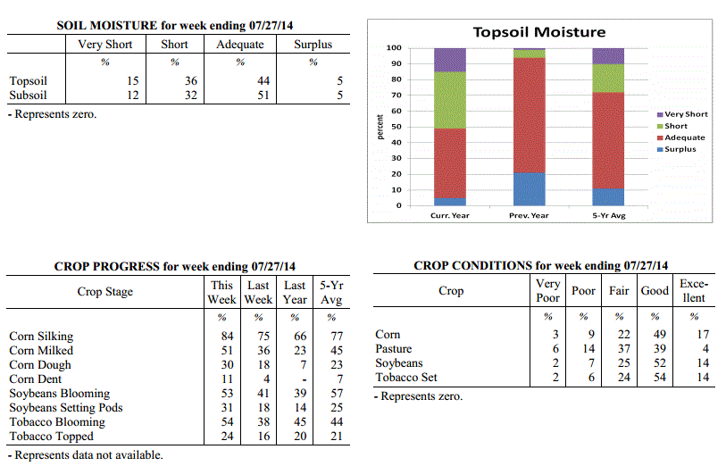 Kentucky Climate Summary
For the Period July 21, 2014 to July 27, 2014
Below Normal Temperatures and Above Normal Rainfall:
It was a very active week across the Commonwealth this past period with a mix of
summer heat, severe weather, and cool conditions. Temperatures were warm to start the
week with highs in the upper 80s to middle 90s on Monday and Tuesday. Dewpoints in
the upper 60s to low 70s pushed the heat index toward the triple digits. Attention
then turned toward a welcoming cold front on Wednesday. After an initial round of
scattered showers and storms, cooler and much drier air moved into the Bluegrass
State for the second half of the work week. Many locations saw temperatures well
below normal, staying in the mid 70s to low 80s. After a warm day Saturday, the rest
of the weekend was dominated by an unsettled pattern. A line of storms worked through
much of the state late Saturday night, before scattered to numerous storms fired on
Sunday. Both were accompanied by isolated reports of damaging winds and large hail.
Portions of Lexington saw straight line winds around 95 mph, while one report from
Leslie County measured hail at over 4 inches in diameter, nearly the size of a
softball. Over the course of the period, much of the state saw significant rainfall
in excess of an inch, but the same cannot be said for Western Kentucky where the dry
trend continues with a quarter inch on average. This was the second straight week of
above normal rainfall after an extended period of dry conditions. Average temperatures
were also near to below normal for the fourth straight week.
Temperatures for the period averaged 75 degrees across the state which was 2 degrees
cooler than normal and 6 degrees warmer than the previous period. High temperatures
averaged from 88 in the West to 82 in the East. Departure from normal high
temperatures ranged from 1 degree cooler than normal in the West to 5 degrees
cooler than normal in the East. Low temperatures averaged from 64 degrees in the
West to 65 degrees in the East. Departure from normal low temperature ranged from 3
degrees cooler than normal in the West to 1 degree warmer than normal in the East.
The extreme high temperature for the period was 97 degrees at HARTFORD 3E and the
extreme low was 52 degrees at BLACK MOUNTAIN ARC.
Precipitation (liq. equ.) for the period totaled 1.17 inches statewide which was 0.21
inches above normal and 122% of normal. Precipitation totals by climate division,
West 0.24 inches, Central 1.23 inches, Bluegrass 1.59 inches and East 1.61 inches,
which was -0.67, 0.26, 0.64 and 0.61 inches respectively from normal. By station,
precipitation totals ranged from a low of 0.00 inches at BOWLING GREEN 5S to a high
of 5.22 inches at WHITLEY CITY 3N.
---
USDA's Kentucky Crop and Weather Report
Issued 4:00 P.M., July 21, 2014, 16-14
Agricultural News: Kentucky experienced scattered rainfall over the past week.
Precipitation for the week totaled 1.48 inches, 0.49 inches above normal.
Temperatures averaged 70 degrees for the week, 7 degrees below normal. Topsoil
moisture was rated 13 percent very short, 35 percent short, 47 percent adequate and 5
percent surplus. Subsoil moisture was rated 10 percent very short, 33 percent short,
52 percent adequate, and 5 percent surplus. Days suitable for fieldwork averaged 5.8
out of a possible seven.
Primary activities this week included spraying soybeans, baling hay, and general farm
maintenance. Parts of the state received much needed rainfall this week, providing
improvement in pasture and crop conditions. However, some areas still remain dry and
pasture and crop conditions continue to deteriorate. Some cattle producers are
beginning to feed hay. There were a few reports of black shank problems starting to
appear in tobacco.
Kentucky Climate Summary
For the Period July 21, 2014 to July 27, 2014
Below Normal Temperatures and Above Normal Rainfall:
It was a very active week across the Commonwealth this past period with a mix of
summer heat, severe weather, and cool conditions. Temperatures were warm to start the
week with highs in the upper 80s to middle 90s on Monday and Tuesday. Dewpoints in
the upper 60s to low 70s pushed the heat index toward the triple digits. Attention
then turned toward a welcoming cold front on Wednesday. After an initial round of
scattered showers and storms, cooler and much drier air moved into the Bluegrass
State for the second half of the work week. Many locations saw temperatures well
below normal, staying in the mid 70s to low 80s. After a warm day Saturday, the rest
of the weekend was dominated by an unsettled pattern. A line of storms worked through
much of the state late Saturday night, before scattered to numerous storms fired on
Sunday. Both were accompanied by isolated reports of damaging winds and large hail.
Portions of Lexington saw straight line winds around 95 mph, while one report from
Leslie County measured hail at over 4 inches in diameter, nearly the size of a
softball. Over the course of the period, much of the state saw significant rainfall
in excess of an inch, but the same cannot be said for Western Kentucky where the dry
trend continues with a quarter inch on average. This was the second straight week of
above normal rainfall after an extended period of dry conditions. Average temperatures
were also near to below normal for the fourth straight week.
Temperatures for the period averaged 75 degrees across the state which was 2 degrees
cooler than normal and 6 degrees warmer than the previous period. High temperatures
averaged from 88 in the West to 82 in the East. Departure from normal high
temperatures ranged from 1 degree cooler than normal in the West to 5 degrees
cooler than normal in the East. Low temperatures averaged from 64 degrees in the
West to 65 degrees in the East. Departure from normal low temperature ranged from 3
degrees cooler than normal in the West to 1 degree warmer than normal in the East.
The extreme high temperature for the period was 97 degrees at HARTFORD 3E and the
extreme low was 52 degrees at BLACK MOUNTAIN ARC.
Precipitation (liq. equ.) for the period totaled 1.17 inches statewide which was 0.21
inches above normal and 122% of normal. Precipitation totals by climate division,
West 0.24 inches, Central 1.23 inches, Bluegrass 1.59 inches and East 1.61 inches,
which was -0.67, 0.26, 0.64 and 0.61 inches respectively from normal. By station,
precipitation totals ranged from a low of 0.00 inches at BOWLING GREEN 5S to a high
of 5.22 inches at WHITLEY CITY 3N.
---
USDA's Kentucky Crop and Weather Report
Issued 4:00 P.M., July 21, 2014, 16-14
Agricultural News: Kentucky experienced scattered rainfall over the past week.
Precipitation for the week totaled 1.48 inches, 0.49 inches above normal.
Temperatures averaged 70 degrees for the week, 7 degrees below normal. Topsoil
moisture was rated 13 percent very short, 35 percent short, 47 percent adequate and 5
percent surplus. Subsoil moisture was rated 10 percent very short, 33 percent short,
52 percent adequate, and 5 percent surplus. Days suitable for fieldwork averaged 5.8
out of a possible seven.
Primary activities this week included spraying soybeans, baling hay, and general farm
maintenance. Parts of the state received much needed rainfall this week, providing
improvement in pasture and crop conditions. However, some areas still remain dry and
pasture and crop conditions continue to deteriorate. Some cattle producers are
beginning to feed hay. There were a few reports of black shank problems starting to
appear in tobacco.
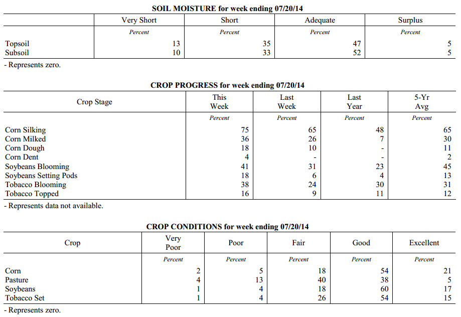 Kentucky Climate Summary
For the Period July 14, 2014 to July 20, 2014
Much Below Normal Temperatures and Above Normal Rainfall:
The Commonwealth finally saw some significant rainfall this past week, along with a
glimpse of early fall. A couple frontal boundaries started the work week off on a
wet note. Scattered to numerous showers and storms formed along a weakening frontal
boundary early Monday, before a stronger cold front moved through the area later that
night. Surface high pressure of Canadian origin then pushed into the region for much
of the remaining work week. Unseasonable temperatures with low dewpoints invaded the
Ohio Valley with highs temperatures only in the 70s about each day. Highs
in the upper 70s are normally not seen until late-September. Record lows were broken
at many locations on Thursday morning, as temperatures plummeted into the low to mid
50s. Some locations even recorded the mercury dropping into the upper 40s. Showers
then redeveloped on Friday, marking the start of extended period of unsettled
conditions heading into the weekend. Rainfall was light in nature, but was present
for an extended period of time, mostly across the eastern half of the state. Overall,
the state was nearly a half inch above normal for the week, which broke a streak of 5
consecutive periods of below normal rainfall.
Temperatures for the period averaged 70 degrees across the state which was 7 degrees
cooler than normal and 6 degrees cooler than the previous period. High temperatures
averaged from 79 in the West to 77 in the East. Departure from normal high
temperatures ranged from 11 degrees cooler than normal in the West to 10 degrees
cooler than normal in the East. Low temperatures averaged from 61 degrees in the
West to 62 degrees in the East. Departure from normal low temperature ranged from 7
degrees cooler than normal in the West to 2 degrees cooler than normal in the East.
The extreme high temperature for the period was 90 degrees at BOWLING GREEN 4E and
the extreme low was 49 degrees at CYNTHIANA 8N.
Precipitation (liq. equ.) for the period totaled 1.48 inches statewide which was 0.49
inches above normal and 149% of normal. Precipitation totals by climate division,
West 0.49 inches, Central 1.06 inches, Bluegrass 1.60 inches and East 2.76 inches,
which was -0.47, 0.05, 0.64 and 1.73 inches respectively from normal. By station,
precipitation totals ranged from a low of 0.06 inches at HARDINSBURG 5SW to a high of
5.59 inches at LONDON.
---
USDA's Kentucky Crop and Weather Report
Issued 4:00 P.M., July 14, 2014, 15-14
Agricultural News: Kentucky experienced dry conditions over the past week.
Precipitation for the week totaled 0.38 inches, 0.61 inches below normal.
Temperatures averaged 77 degrees for the week, near normal. Topsoil moisture was
rated 11 percent very short, 39 percent short, 45 percent adequate and 5 percent
surplus. Subsoil moisture was rated 9 percent very short, 34 percent short, 52
percent adequate, and 5 percent surplus. Days suitable for fieldwork averaged 6.2 out
of a possible seven.
Primary activities this week include spraying soybeans, harvesting wheat, and baling
hay. Crop conditions are deteriorating in some areas as dry conditions continue.
There were a few reports of corn curling and looking drought stressed. Pastures are
drying up and some cattle producers are starting to feed hay. A few producers
reported vomitoxin in wheat.
Kentucky Climate Summary
For the Period July 14, 2014 to July 20, 2014
Much Below Normal Temperatures and Above Normal Rainfall:
The Commonwealth finally saw some significant rainfall this past week, along with a
glimpse of early fall. A couple frontal boundaries started the work week off on a
wet note. Scattered to numerous showers and storms formed along a weakening frontal
boundary early Monday, before a stronger cold front moved through the area later that
night. Surface high pressure of Canadian origin then pushed into the region for much
of the remaining work week. Unseasonable temperatures with low dewpoints invaded the
Ohio Valley with highs temperatures only in the 70s about each day. Highs
in the upper 70s are normally not seen until late-September. Record lows were broken
at many locations on Thursday morning, as temperatures plummeted into the low to mid
50s. Some locations even recorded the mercury dropping into the upper 40s. Showers
then redeveloped on Friday, marking the start of extended period of unsettled
conditions heading into the weekend. Rainfall was light in nature, but was present
for an extended period of time, mostly across the eastern half of the state. Overall,
the state was nearly a half inch above normal for the week, which broke a streak of 5
consecutive periods of below normal rainfall.
Temperatures for the period averaged 70 degrees across the state which was 7 degrees
cooler than normal and 6 degrees cooler than the previous period. High temperatures
averaged from 79 in the West to 77 in the East. Departure from normal high
temperatures ranged from 11 degrees cooler than normal in the West to 10 degrees
cooler than normal in the East. Low temperatures averaged from 61 degrees in the
West to 62 degrees in the East. Departure from normal low temperature ranged from 7
degrees cooler than normal in the West to 2 degrees cooler than normal in the East.
The extreme high temperature for the period was 90 degrees at BOWLING GREEN 4E and
the extreme low was 49 degrees at CYNTHIANA 8N.
Precipitation (liq. equ.) for the period totaled 1.48 inches statewide which was 0.49
inches above normal and 149% of normal. Precipitation totals by climate division,
West 0.49 inches, Central 1.06 inches, Bluegrass 1.60 inches and East 2.76 inches,
which was -0.47, 0.05, 0.64 and 1.73 inches respectively from normal. By station,
precipitation totals ranged from a low of 0.06 inches at HARDINSBURG 5SW to a high of
5.59 inches at LONDON.
---
USDA's Kentucky Crop and Weather Report
Issued 4:00 P.M., July 14, 2014, 15-14
Agricultural News: Kentucky experienced dry conditions over the past week.
Precipitation for the week totaled 0.38 inches, 0.61 inches below normal.
Temperatures averaged 77 degrees for the week, near normal. Topsoil moisture was
rated 11 percent very short, 39 percent short, 45 percent adequate and 5 percent
surplus. Subsoil moisture was rated 9 percent very short, 34 percent short, 52
percent adequate, and 5 percent surplus. Days suitable for fieldwork averaged 6.2 out
of a possible seven.
Primary activities this week include spraying soybeans, harvesting wheat, and baling
hay. Crop conditions are deteriorating in some areas as dry conditions continue.
There were a few reports of corn curling and looking drought stressed. Pastures are
drying up and some cattle producers are starting to feed hay. A few producers
reported vomitoxin in wheat.
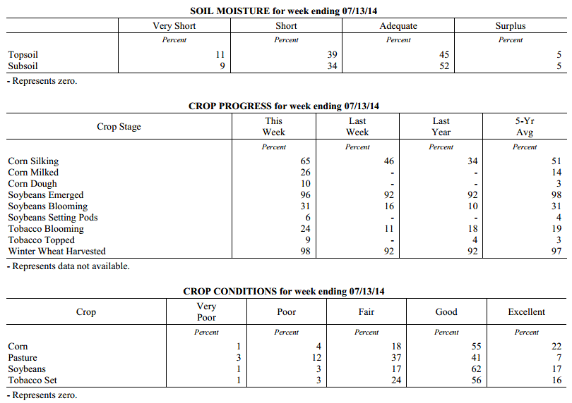 Kentucky Climate Summary
For the Period July 7, 2014 to July 13, 2014
Near Normal Temperatures and Below Normal Rainfall:
Dry conditions continued to control the weather pattern this past week across the
Commonwealth. The state averaged under a half inch for the week, which made for
the fifth straight period of below normal rainfall. This led to an intensification of
drought conditions with the US Drought Monitor now reporting 48% of the state as
abnormally dry and a slight portion of Southeastern Kentucky in a Moderate Drought.
As high pressure pushed east over the weekend, southerly flow brought scorching heat
and humidity back to the region. Highs by Sunday were in the low to mid 90s for much
of the Commonwealth along with the heat index around 100 degrees. Louisville even hit a
high of 97. Scattered storms developed across the region during the afternoon and
evening hours as instability was on the rise and a weak front pushed through the
area. Significant rainfall totals of greater than a half inch were limited to
locations across East-central Kentucky and north into the Bluegrass.
Temperatures for the period averaged 77 degrees across the state which was near
normal and 4 degrees warmer than the previous period. High temperatures averaged from
88 in the West to 88 in the East. Departure from normal high temperatures ranged from
1 degree cooler than normal in the West to 1 degree warmer than normal in the East.
Low temperatures averaged from 67 degrees in the West to 65 degrees in the East.
Departure from normal low temperature ranged from near normal in the West to 2
degrees warmer than normal in the East. The extreme high temperature for the period
was 97 degrees at LOUISA 1S and the extreme low was 56 degrees at CYNTHIANA 8N.
Precipitation (liq. equ.) for the period totaled 0.38 inches statewide which was 0.61
inches below normal and 38% of normal. Precipitation totals by climate division, West
0.38 inches, Central 0.41 inches, Bluegrass 0.23 inches and East 0.51 inches, which
was 0.6, 0.59, 0.74 and 0.49 inches below normal. By station, precipitation totals
ranged from a low of 0.00 inches at BIG SANDY to a high of 1.51 inches at MIDDLESBORO AWOS.
---
USDA's Kentucky Crop and Weather Report
Issued 4:00 P.M., July 7, 2014, 14-14
Agricultural News: Kentucky experienced dry and cool conditions over the past week.
Precipitation for the week totaled 0.38 inches, 0.61 inches below normal. Temperatures
averaged 73 degrees for the week, 3 degrees below normal. Topsoil moisture was rated 6
percent very short, 30 percent short, 58 percent adequate and 6 percent surplus.
Subsoil moisture was rated 4 percent very short, 28 percent short, 62 percent
adequate, and 6 percent surplus. Days suitable for fieldwork averaged 5.8 out of a
possible seven. Primary activities this week included planting soybeans and harvesting
wheat and hay.
Producers are finishing up with the wheat harvest and double crop soybean planting.
The average height of emerged soybeans was 17 inches. Most early planted corn looks
good, but in some locations the later fields are curling due to lack of moisture.
There were reports this week of blank shank and fusarium wilt in a few tobacco fields.
Pasture and crop conditions are starting to decline in some areas due to lack of
moisture. Farmers were bush hogging fields and performing general maintenance as they
finished up planting row crops.
Kentucky Climate Summary
For the Period July 7, 2014 to July 13, 2014
Near Normal Temperatures and Below Normal Rainfall:
Dry conditions continued to control the weather pattern this past week across the
Commonwealth. The state averaged under a half inch for the week, which made for
the fifth straight period of below normal rainfall. This led to an intensification of
drought conditions with the US Drought Monitor now reporting 48% of the state as
abnormally dry and a slight portion of Southeastern Kentucky in a Moderate Drought.
As high pressure pushed east over the weekend, southerly flow brought scorching heat
and humidity back to the region. Highs by Sunday were in the low to mid 90s for much
of the Commonwealth along with the heat index around 100 degrees. Louisville even hit a
high of 97. Scattered storms developed across the region during the afternoon and
evening hours as instability was on the rise and a weak front pushed through the
area. Significant rainfall totals of greater than a half inch were limited to
locations across East-central Kentucky and north into the Bluegrass.
Temperatures for the period averaged 77 degrees across the state which was near
normal and 4 degrees warmer than the previous period. High temperatures averaged from
88 in the West to 88 in the East. Departure from normal high temperatures ranged from
1 degree cooler than normal in the West to 1 degree warmer than normal in the East.
Low temperatures averaged from 67 degrees in the West to 65 degrees in the East.
Departure from normal low temperature ranged from near normal in the West to 2
degrees warmer than normal in the East. The extreme high temperature for the period
was 97 degrees at LOUISA 1S and the extreme low was 56 degrees at CYNTHIANA 8N.
Precipitation (liq. equ.) for the period totaled 0.38 inches statewide which was 0.61
inches below normal and 38% of normal. Precipitation totals by climate division, West
0.38 inches, Central 0.41 inches, Bluegrass 0.23 inches and East 0.51 inches, which
was 0.6, 0.59, 0.74 and 0.49 inches below normal. By station, precipitation totals
ranged from a low of 0.00 inches at BIG SANDY to a high of 1.51 inches at MIDDLESBORO AWOS.
---
USDA's Kentucky Crop and Weather Report
Issued 4:00 P.M., July 7, 2014, 14-14
Agricultural News: Kentucky experienced dry and cool conditions over the past week.
Precipitation for the week totaled 0.38 inches, 0.61 inches below normal. Temperatures
averaged 73 degrees for the week, 3 degrees below normal. Topsoil moisture was rated 6
percent very short, 30 percent short, 58 percent adequate and 6 percent surplus.
Subsoil moisture was rated 4 percent very short, 28 percent short, 62 percent
adequate, and 6 percent surplus. Days suitable for fieldwork averaged 5.8 out of a
possible seven. Primary activities this week included planting soybeans and harvesting
wheat and hay.
Producers are finishing up with the wheat harvest and double crop soybean planting.
The average height of emerged soybeans was 17 inches. Most early planted corn looks
good, but in some locations the later fields are curling due to lack of moisture.
There were reports this week of blank shank and fusarium wilt in a few tobacco fields.
Pasture and crop conditions are starting to decline in some areas due to lack of
moisture. Farmers were bush hogging fields and performing general maintenance as they
finished up planting row crops.
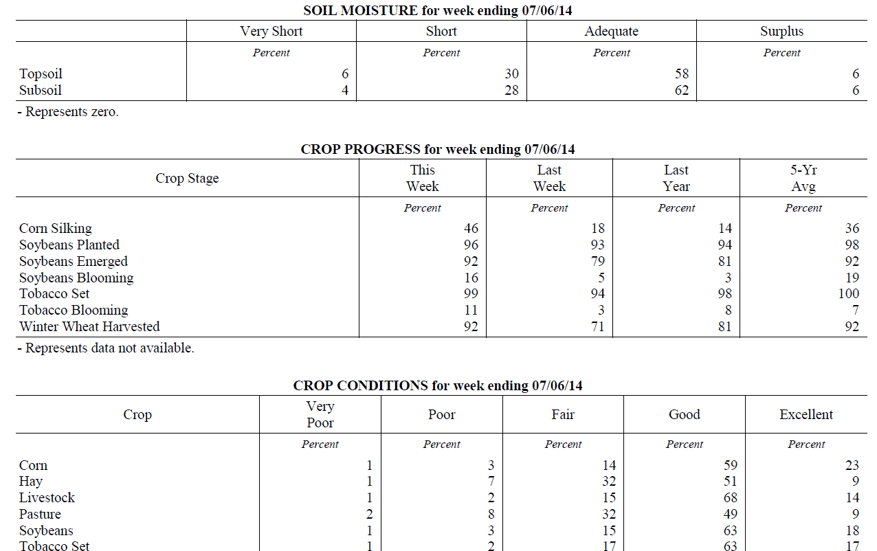 Kentucky Climate Summary
For the Period June 30, 2014 to July 06, 2014
Below Normal Temperatures and Below Normal Rainfall:
The first week of July continued the drier and cooler than normal pattern of past
weeks as another dry and cooler week occurred for the Bluegrass state. The week
started mild and became below normal on temperatures for the latter half of the week.
Those locations in the state with the driest conditions also suffered the least
rainfall last week, especially east and south. This was the 4th week with mostly below
normal rainfall.
Temperatures for the period averaged 73 degrees across the state which was 3 degrees
cooler than normal and 4 degrees cooler than the previous period. High temperatures
averaged from 84 in the West to 83 in the East. Departure from normal high
temperatures ranged from 5 degrees cooler than normal in the West to 3 degrees cooler
than normal in the East. Low temperatures averaged from 63 degrees in the West to 63
degrees in the East. Departure from normal low temperature ranged from 4 degrees
cooler than normal in the West to 1 degree warmer than normal in the East. The extreme
high temperature for the period was 95 degrees at Bowling Green and the extreme low
was 50 degrees at Covington.
Rainfall for the period totaled 0.38 inches statewide which was 0.61 inches below
normal and 38% of normal. Rainfall totals by climate division, West 0.65 inches,
Central 0.33 inches, Bluegrass 0.43 inches and East 0.11 inches, which was 0.34, 0.65,
0.53 and 0.91 inches below normal. By station, precipitation totals ranged from a low
of 0.00 inches at Big Sandy to a high of 2.22 inches at Evansville.
---
USDA's Kentucky Crop and Weather Report
Issued 4:00 P.M., June 30, 2014 13-14
Agricultural News: Kentucky experienced above normal temperatures and near normal
rainfall over the past week. Precipitation for the week totaled 0.95 inches, 0.05
inches below normal. Temperatures averaged 77 degrees for the week, 2 degrees above
normal. Topsoil moisture was rated 4 percent very short, 24 percent short, 64 percent
adequate and 8 percent surplus. Subsoil moisture was rated 3 percent very short, 23
percent short, 66 percent adequate, and 8 percent surplus. Days suitable for
fieldwork averaged 5.2 out of a possible seven.
Primary activities this week included harvesting wheat and planting soybeans. Some
areas of the state are dry while others have received rain from spotty showers. These
conditions have had strong effects on hay and the second cutting. Reports of low
quantity and low quality in hay have surfaced. Wheat harvest is in full swing. Yields
appear to be good, but vomitoxin is being reported, especially in fields that were
not treated. Double crop soybeans are being planted as wheat is harvested. Early
soybeans are now starting to bloom. Soybean average height was 10 inches. Tobacco
average height was 19 inches.
Kentucky Climate Summary
For the Period June 30, 2014 to July 06, 2014
Below Normal Temperatures and Below Normal Rainfall:
The first week of July continued the drier and cooler than normal pattern of past
weeks as another dry and cooler week occurred for the Bluegrass state. The week
started mild and became below normal on temperatures for the latter half of the week.
Those locations in the state with the driest conditions also suffered the least
rainfall last week, especially east and south. This was the 4th week with mostly below
normal rainfall.
Temperatures for the period averaged 73 degrees across the state which was 3 degrees
cooler than normal and 4 degrees cooler than the previous period. High temperatures
averaged from 84 in the West to 83 in the East. Departure from normal high
temperatures ranged from 5 degrees cooler than normal in the West to 3 degrees cooler
than normal in the East. Low temperatures averaged from 63 degrees in the West to 63
degrees in the East. Departure from normal low temperature ranged from 4 degrees
cooler than normal in the West to 1 degree warmer than normal in the East. The extreme
high temperature for the period was 95 degrees at Bowling Green and the extreme low
was 50 degrees at Covington.
Rainfall for the period totaled 0.38 inches statewide which was 0.61 inches below
normal and 38% of normal. Rainfall totals by climate division, West 0.65 inches,
Central 0.33 inches, Bluegrass 0.43 inches and East 0.11 inches, which was 0.34, 0.65,
0.53 and 0.91 inches below normal. By station, precipitation totals ranged from a low
of 0.00 inches at Big Sandy to a high of 2.22 inches at Evansville.
---
USDA's Kentucky Crop and Weather Report
Issued 4:00 P.M., June 30, 2014 13-14
Agricultural News: Kentucky experienced above normal temperatures and near normal
rainfall over the past week. Precipitation for the week totaled 0.95 inches, 0.05
inches below normal. Temperatures averaged 77 degrees for the week, 2 degrees above
normal. Topsoil moisture was rated 4 percent very short, 24 percent short, 64 percent
adequate and 8 percent surplus. Subsoil moisture was rated 3 percent very short, 23
percent short, 66 percent adequate, and 8 percent surplus. Days suitable for
fieldwork averaged 5.2 out of a possible seven.
Primary activities this week included harvesting wheat and planting soybeans. Some
areas of the state are dry while others have received rain from spotty showers. These
conditions have had strong effects on hay and the second cutting. Reports of low
quantity and low quality in hay have surfaced. Wheat harvest is in full swing. Yields
appear to be good, but vomitoxin is being reported, especially in fields that were
not treated. Double crop soybeans are being planted as wheat is harvested. Early
soybeans are now starting to bloom. Soybean average height was 10 inches. Tobacco
average height was 19 inches.
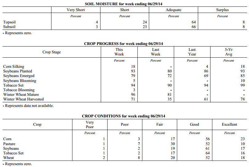 Kentucky Climate Summary
For the Period June 23, 2014 to June 29, 2014
Above Normal Temperatures and Near Normal Rainfall:
The closing week of June kept warm temperatures in place across the Commonwealth,
along with some beneficial rainfall. Storm coverage was isolated to scattered just
about each day of the period within a moist and unstable air mass. Overall, the state
averaged just under an inch, which was slightly below normal. This ended up being the
third straight period with below normal rainfall and in turn, dry conditions were
becoming evident across the Lower Ohio Valley. The latest US Drought Monitor now has
nearly 53% of the state as showing signs of being abnormally dry, along with a slight
portion of Southeastern Kentucky in a moderate drought.
Temperatures for the period averaged 77 degrees across the state which was 2 degrees
warmer than normal and 2 degrees cooler than the previous period. High temperatures
averaged from 85 in the West to 85 in the East. Departure from normal high
temperatures ranged from 3 degrees cooler than normal in the West to near normal in
the East. Low temperatures averaged from 69 degrees in the West to 67 degrees in the
East. Departure from normal low temperature ranged from 4 degrees warmer than normal
in the West to 6 degrees warmer than normal in the East. The extreme high temperature
for the period was 94 degrees at CARLISLE 5SW and the extreme low was 53 degrees at
WILLIAMSBURG AWOS.
Precipitation (liq. equ.) for the period totaled 0.95 inches statewide which was 0.05
inches below normal and 95% of normal. Precipitation totals by climate division, West
0.87 inches, Central 0.90 inches, Bluegrass 1.07 inches and East 0.97 inches, which
was -0.12, -0.08, 0.09 and -0.06 inches respectively from normal. By station,
precipitation totals ranged from a low of 0.00 inches at BIG SANDY to a high of 2.71
inches at CAPE GIRARDEAU ASOS.
---
USDA's Kentucky Crop and Weather Report
Issued 4:00 P.M., June 23, 2014 12-14
Agricultural News: Kentucky experienced above normal temperatures and below normal
rainfall over the past week. Precipitation for the week totaled 0.47 inches, 0.54
inches below normal. Temperatures averaged 78 degrees for the week, 5 degrees above
normal. Topsoil moisture was rated 4 percent very short, 20 percent short, 66 percent
adequate and 10 percent surplus. Subsoil moisture was rated 3 percent very short, 18
percent short, 72 percent adequate, and 7 percent surplus. Days suitable for
fieldwork averaged 5.9 out of a possible seven.
Primary activities this week planting soybeans, harvesting wheat, and cutting hay.
Crops are in need of rain in some conditions, as dry conditions persist. Other areas
have received adequate moisture. With hay cutting currently under way, reports of
reduced and low yields have surfaced. Also, counts of vomitoxin in wheat have been
reported. Corn average height was 39 inches. Tobacco average height was 14 inches.
Kentucky Climate Summary
For the Period June 23, 2014 to June 29, 2014
Above Normal Temperatures and Near Normal Rainfall:
The closing week of June kept warm temperatures in place across the Commonwealth,
along with some beneficial rainfall. Storm coverage was isolated to scattered just
about each day of the period within a moist and unstable air mass. Overall, the state
averaged just under an inch, which was slightly below normal. This ended up being the
third straight period with below normal rainfall and in turn, dry conditions were
becoming evident across the Lower Ohio Valley. The latest US Drought Monitor now has
nearly 53% of the state as showing signs of being abnormally dry, along with a slight
portion of Southeastern Kentucky in a moderate drought.
Temperatures for the period averaged 77 degrees across the state which was 2 degrees
warmer than normal and 2 degrees cooler than the previous period. High temperatures
averaged from 85 in the West to 85 in the East. Departure from normal high
temperatures ranged from 3 degrees cooler than normal in the West to near normal in
the East. Low temperatures averaged from 69 degrees in the West to 67 degrees in the
East. Departure from normal low temperature ranged from 4 degrees warmer than normal
in the West to 6 degrees warmer than normal in the East. The extreme high temperature
for the period was 94 degrees at CARLISLE 5SW and the extreme low was 53 degrees at
WILLIAMSBURG AWOS.
Precipitation (liq. equ.) for the period totaled 0.95 inches statewide which was 0.05
inches below normal and 95% of normal. Precipitation totals by climate division, West
0.87 inches, Central 0.90 inches, Bluegrass 1.07 inches and East 0.97 inches, which
was -0.12, -0.08, 0.09 and -0.06 inches respectively from normal. By station,
precipitation totals ranged from a low of 0.00 inches at BIG SANDY to a high of 2.71
inches at CAPE GIRARDEAU ASOS.
---
USDA's Kentucky Crop and Weather Report
Issued 4:00 P.M., June 23, 2014 12-14
Agricultural News: Kentucky experienced above normal temperatures and below normal
rainfall over the past week. Precipitation for the week totaled 0.47 inches, 0.54
inches below normal. Temperatures averaged 78 degrees for the week, 5 degrees above
normal. Topsoil moisture was rated 4 percent very short, 20 percent short, 66 percent
adequate and 10 percent surplus. Subsoil moisture was rated 3 percent very short, 18
percent short, 72 percent adequate, and 7 percent surplus. Days suitable for
fieldwork averaged 5.9 out of a possible seven.
Primary activities this week planting soybeans, harvesting wheat, and cutting hay.
Crops are in need of rain in some conditions, as dry conditions persist. Other areas
have received adequate moisture. With hay cutting currently under way, reports of
reduced and low yields have surfaced. Also, counts of vomitoxin in wheat have been
reported. Corn average height was 39 inches. Tobacco average height was 14 inches.
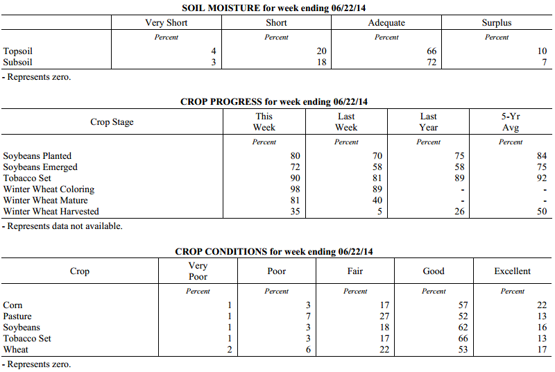 Kentucky Climate Summary
For the Period June 16, 2014 to June 22, 2014
Above Normal Temperatures and Below Normal Rainfall:
The summer season started in full force this past period with warm and humid
conditions in place. The majority of the week was controlled by above normal
temperatures with highs getting into the upper 80s to low 90s each day. A moist
atmosphere with dewpoints in the upper 60s to low 70s helped push the heat index into
the mid 90s to around 100 at times. This sent the livestock heat stress index into
the danger category about each day during the afternoon and early evening hours.
High pressure aloft kept the Commonwealth dry for the first half of the week. This
feature then broke down Thursday and allowed for daily, isolated to scattered showers
and thunderstorms for the remainder of the period. The overall dry nature of the
week sent the Bluegrass State to a second straight period of below normal rainfall
and the fourth out of the past five weeks.
Temperatures for the period averaged 78 degrees across the state which was 5 degrees
warmer than normal and 8 degrees warmer than the previous period. High temperatures
averaged from 90 in the West to 87 in the East. Departure from normal high
temperatures ranged from 3 degrees warmer than normal in the West to 3 degrees
warmer than normal in the East. Low temperatures averaged from 70 degrees in the
West to 66 degrees in the East. Departure from normal low temperature ranged from 6
degrees warmer than normal in the West to 7 degrees warmer than normal in the East.
The extreme high temperature for the period was 94 degrees at CAPE GIRARDEAU ASOS and
the extreme low was 59 degrees at LIBERTY 3SW.
Precipitation (liq. equ.) for the period totaled 0.47 inches statewide which was 0.54
inches below normal and 46% of normal. Precipitation totals by climate division, West
0.12 inches, Central 0.40 inches, Bluegrass 0.50 inches and East 0.85 inches, which
was 0.88, 0.6, 0.52 and 0.18 inches below normal. By station, precipitation totals
ranged from a low of 0.00 inches at CADIZ 4SW to a high of 1.98 inches at BARBOURVILLE 3E.
---
USDA's Kentucky Crop and Weather Report
Issued 4:00 P.M., June 16, 2014 11-14
Agricultural News: Kentucky experienced below normal temperatures and precipitation
over the past week. Precipitation for the week totaled 0.80 inches, 0.23 inches below
normal. Temperatures averaged 70 degrees for the week, 2 degrees below normal.
Topsoil moisture was rated 1 percent very short, 11 percent short, 70 percent
adequate and 18 percent surplus. Subsoil moisture was rated 1 percent very short, 12
percent short, 72 percent adequate, and 15 percent surplus. Days suitable for
fieldwork averaged 3.9 out of a possible seven.
Primary activities this week included planting soybeans and tobacco. Producers
continued side dressing corn and spraying post herbicide applications. There were
reports of wind damage and Fusarium head blight in wheat which could impact yields in
affected areas. Winter wheat grain harvest is expected to begin in earnest within the
next 1-2 weeks, depending on location. Pastures are growing well due to the recent
rains and livestock are benefiiting from good conditions. Hay harvest is behind
schedule in many areas, resulting in an over mature first cutting. Corn emerged
average height was 26 inches. The average height of set tobacco in the field was 10 inches.
Kentucky Climate Summary
For the Period June 16, 2014 to June 22, 2014
Above Normal Temperatures and Below Normal Rainfall:
The summer season started in full force this past period with warm and humid
conditions in place. The majority of the week was controlled by above normal
temperatures with highs getting into the upper 80s to low 90s each day. A moist
atmosphere with dewpoints in the upper 60s to low 70s helped push the heat index into
the mid 90s to around 100 at times. This sent the livestock heat stress index into
the danger category about each day during the afternoon and early evening hours.
High pressure aloft kept the Commonwealth dry for the first half of the week. This
feature then broke down Thursday and allowed for daily, isolated to scattered showers
and thunderstorms for the remainder of the period. The overall dry nature of the
week sent the Bluegrass State to a second straight period of below normal rainfall
and the fourth out of the past five weeks.
Temperatures for the period averaged 78 degrees across the state which was 5 degrees
warmer than normal and 8 degrees warmer than the previous period. High temperatures
averaged from 90 in the West to 87 in the East. Departure from normal high
temperatures ranged from 3 degrees warmer than normal in the West to 3 degrees
warmer than normal in the East. Low temperatures averaged from 70 degrees in the
West to 66 degrees in the East. Departure from normal low temperature ranged from 6
degrees warmer than normal in the West to 7 degrees warmer than normal in the East.
The extreme high temperature for the period was 94 degrees at CAPE GIRARDEAU ASOS and
the extreme low was 59 degrees at LIBERTY 3SW.
Precipitation (liq. equ.) for the period totaled 0.47 inches statewide which was 0.54
inches below normal and 46% of normal. Precipitation totals by climate division, West
0.12 inches, Central 0.40 inches, Bluegrass 0.50 inches and East 0.85 inches, which
was 0.88, 0.6, 0.52 and 0.18 inches below normal. By station, precipitation totals
ranged from a low of 0.00 inches at CADIZ 4SW to a high of 1.98 inches at BARBOURVILLE 3E.
---
USDA's Kentucky Crop and Weather Report
Issued 4:00 P.M., June 16, 2014 11-14
Agricultural News: Kentucky experienced below normal temperatures and precipitation
over the past week. Precipitation for the week totaled 0.80 inches, 0.23 inches below
normal. Temperatures averaged 70 degrees for the week, 2 degrees below normal.
Topsoil moisture was rated 1 percent very short, 11 percent short, 70 percent
adequate and 18 percent surplus. Subsoil moisture was rated 1 percent very short, 12
percent short, 72 percent adequate, and 15 percent surplus. Days suitable for
fieldwork averaged 3.9 out of a possible seven.
Primary activities this week included planting soybeans and tobacco. Producers
continued side dressing corn and spraying post herbicide applications. There were
reports of wind damage and Fusarium head blight in wheat which could impact yields in
affected areas. Winter wheat grain harvest is expected to begin in earnest within the
next 1-2 weeks, depending on location. Pastures are growing well due to the recent
rains and livestock are benefiiting from good conditions. Hay harvest is behind
schedule in many areas, resulting in an over mature first cutting. Corn emerged
average height was 26 inches. The average height of set tobacco in the field was 10 inches.
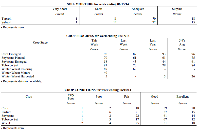 Kentucky Climate Summary
For the Period June 9, 2014 to June 15, 2014
Below Normal Temperatures and Rainfall:
The second week of June was met with a return to cooler temperatures and dry
conditions deepening across the state. The only significant rainfall event for the
period came Tuesday and Wednesday as low pressure pushed from the Southern Plains to
the Lower Great Lakes. Strong to severe storms fired along a line late Tuesday and
into the overnight with wind damage as the primary threat. Precipitation varied
across the state during this event with many seeing less than a half inch. The
exception came along East-Central Kentucky and up into the Bluegrass with totals
around an inch. The state was mostly dry for much of the remainder of the work week.
The latest US Drought Monitor now has a quarter of the state as abnormally dry
with even a slight portion of Southeastern Kentucky in the moderate drought category.
Low pressure kept clouds in place, which limited daytime highs to the mid 70s to low
80s for much of the week. High pressure of Canadian origin moved into the area to
start the weekend. Skies became clear and winds went calm Friday night, allowing for
temperatures to drop into the upper 40s for quite a few locations.
Temperatures for the period averaged 70 degrees across the state which was 2 degrees
cooler than normal and 2 degrees cooler than the previous period. High temperatures
averaged from 80 in the West to 80 in the East. Departure from normal high
temperatures ranged from 5 degrees cooler than normal in the West to 3 degrees
cooler than normal in the East. Low temperatures averaged from 62 degrees in the
West to 59 degrees in the East. Departure from normal low temperature ranged from 1
degree cooler than normal in the West to 1 degree warmer than normal in the East.
The extreme high temperature for the period was 90 degrees at BOWLING GREEN 5S and
the extreme low was 44 degrees at CYNTHIANA 8N.
Precipitation (liq. equ.) for the period totaled 0.80 inches statewide which was 0.23
inches below normal and 78% of normal. Precipitation totals by climate division, West
1.03 inches, Central 0.81 inches, Bluegrass 0.77 inches and East 0.60 inches, which
was 0.05, -0.23, -0.28 and -0.45 inches respectively from normal. By station,
precipitation totals ranged from a low of 0.06 inches at HAZARD AWOS to a high of
2.33 inches at CAPE GIRARDEAU ASOS.
---
USDA's Kentucky Crop and Weather Report
Issued 4:00 P.M., June 9, 2014 10-14
Agricultural News: Kentucky experienced above normal temperatures and rainfall over
the past week. Precipitation for the week totaled 1.23 inches, 0.14 inches above
normal. Temperatures averaged 72 degrees for the week, 2 degrees above normal.
Topsoil moisture was rated 2 percent very short, 12 percent short, 68 percent
adequate and 18 percent surplus. Subsoil moisture was rated 1 percent very short, 11
percent short, 74 percent adequate, and 14 percent surplus. Days suitable for
fieldwork averaged 4.1 out of a possible seven.
Primary activities this week included planting soybeans and tobacco, hay cutting,
fungicide applications, and side dressing corn. A lot of first cutting hay is still
standing, resulting in over maturity and decreased quality. Pastures are growing well
due to the recent rains. Some areas are getting dry while others have had plenty of
moisture. Corn average height was 17 inches. The average height of set tobacco in the
field was 7 inches.
Kentucky Climate Summary
For the Period June 9, 2014 to June 15, 2014
Below Normal Temperatures and Rainfall:
The second week of June was met with a return to cooler temperatures and dry
conditions deepening across the state. The only significant rainfall event for the
period came Tuesday and Wednesday as low pressure pushed from the Southern Plains to
the Lower Great Lakes. Strong to severe storms fired along a line late Tuesday and
into the overnight with wind damage as the primary threat. Precipitation varied
across the state during this event with many seeing less than a half inch. The
exception came along East-Central Kentucky and up into the Bluegrass with totals
around an inch. The state was mostly dry for much of the remainder of the work week.
The latest US Drought Monitor now has a quarter of the state as abnormally dry
with even a slight portion of Southeastern Kentucky in the moderate drought category.
Low pressure kept clouds in place, which limited daytime highs to the mid 70s to low
80s for much of the week. High pressure of Canadian origin moved into the area to
start the weekend. Skies became clear and winds went calm Friday night, allowing for
temperatures to drop into the upper 40s for quite a few locations.
Temperatures for the period averaged 70 degrees across the state which was 2 degrees
cooler than normal and 2 degrees cooler than the previous period. High temperatures
averaged from 80 in the West to 80 in the East. Departure from normal high
temperatures ranged from 5 degrees cooler than normal in the West to 3 degrees
cooler than normal in the East. Low temperatures averaged from 62 degrees in the
West to 59 degrees in the East. Departure from normal low temperature ranged from 1
degree cooler than normal in the West to 1 degree warmer than normal in the East.
The extreme high temperature for the period was 90 degrees at BOWLING GREEN 5S and
the extreme low was 44 degrees at CYNTHIANA 8N.
Precipitation (liq. equ.) for the period totaled 0.80 inches statewide which was 0.23
inches below normal and 78% of normal. Precipitation totals by climate division, West
1.03 inches, Central 0.81 inches, Bluegrass 0.77 inches and East 0.60 inches, which
was 0.05, -0.23, -0.28 and -0.45 inches respectively from normal. By station,
precipitation totals ranged from a low of 0.06 inches at HAZARD AWOS to a high of
2.33 inches at CAPE GIRARDEAU ASOS.
---
USDA's Kentucky Crop and Weather Report
Issued 4:00 P.M., June 9, 2014 10-14
Agricultural News: Kentucky experienced above normal temperatures and rainfall over
the past week. Precipitation for the week totaled 1.23 inches, 0.14 inches above
normal. Temperatures averaged 72 degrees for the week, 2 degrees above normal.
Topsoil moisture was rated 2 percent very short, 12 percent short, 68 percent
adequate and 18 percent surplus. Subsoil moisture was rated 1 percent very short, 11
percent short, 74 percent adequate, and 14 percent surplus. Days suitable for
fieldwork averaged 4.1 out of a possible seven.
Primary activities this week included planting soybeans and tobacco, hay cutting,
fungicide applications, and side dressing corn. A lot of first cutting hay is still
standing, resulting in over maturity and decreased quality. Pastures are growing well
due to the recent rains. Some areas are getting dry while others have had plenty of
moisture. Corn average height was 17 inches. The average height of set tobacco in the
field was 7 inches.
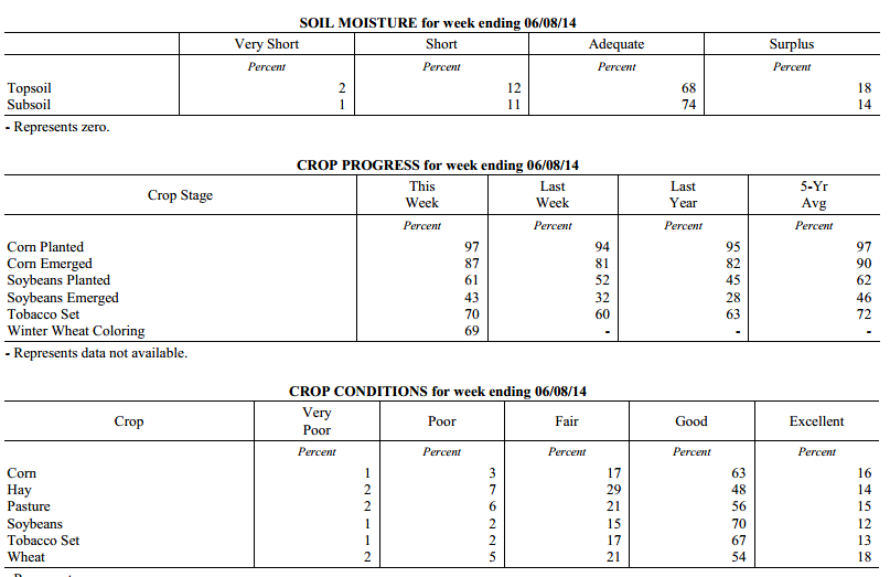 Kentucky Climate Summary
For the Period June 2, 2014 to June 8, 2014
Above Normal Temperatures and Rainfall:
A much more active pattern set up this past week across the Lower Ohio Valley. While
data shows the state receiving above normal rainfall, this can be somewhat misleading.
Most activity occurred across Western Kentucky, before diminishing farther east. The
west averaged over 2.5 inches over the course of the period, while Central Kentucky
saw less than a half inch. Much of the action came over the course of a couple storm
systems. The first pushed through the area on Wednesday. Scattered, strong to
severe storms fired across the entire state. These storms exhibited about every type
of severe weather from damaging winds, hail, to tornados. Straight line winds with
peak gusts of 95 mph were reported in Western Kentucky, along with a couple weak
tornados. Some activity lingered into Thursday, before the Commonwealth became under
the influence of high pressure to end the work week. Low pressure then passed north
of the state late Saturday and into Sunday. Once again, the main activity was
centered across Western Kentucky, before diminishing farther east. Rainfall has been
below normal across Eastern Kentucky over each of the past 5 weeks. Portions of this
area are now showing abnormally dry conditions.
Temperatures for the period averaged 72 degrees across the state which was 2 degrees
warmer than normal and 2 degrees cooler than the previous period. High temperatures
averaged from 81 in the West to 80 in the East. Departure from normal high
temperatures ranged from 2 degrees cooler than normal in the West to 1 degree
cooler than normal in the East. Low temperatures averaged from 68 degrees in the
West to 62 degrees in the East. Departure from normal low temperature ranged from 7
degrees warmer than normal in the West to 6 degrees warmer than normal in the East.
The extreme high temperature for the period was 90 degrees at PADUCAH ASOS and the
extreme low was 48 degrees at VANCEBURG 6W.
Precipitation (liq. equ.) for the period totaled 1.23 inches statewide which was 0.14
inches above normal and 113% of normal. Precipitation totals by climate division,
West 2.70 inches, Central 0.40 inches, Bluegrass 1.12 inches and East 0.70 inches,
which was 1.65, -0.70, 0.02 and -0.39 inches respectively from normal. By station,
precipitation totals ranged from a low of 0.00 inches at BLACK MOUNTAIN ARC to a high
of 7.40 inches at MAYFIELD 6SW.
---
USDA's Kentucky Crop and Weather Report
Issued 4:00 P.M., June 2, 2014 9-14
Agricultural News: Kentucky experienced above normal temperatures and below normal
rainfall over the past week. Precipitation for the week totaled 0.36 inches, 0.76
inches below normal. Temperatures averaged 73 degrees for the week, 5 degrees above
normal. Topsoil moisture was rated 1 percent very short, 11 percent short, 74 percent
adequate and 14 percent surplus. Subsoil moisture was rated 1 percent very short, 9
percent short, 79 percent adequate, and 11 percent surplus. Days suitable for
fieldwork averaged 5.4 out of a possible seven. Primary activities this week included
planting corn, soybeans and tobacco.
Farmers were also busy cutting and baling hay as weather permitted. There were some
reports of cut worms in corn. Producers continued spraying herbicides on corn and
soybean fields and applied nitrogen on corn fields. Corn average height was 9 inches.
Hay harvest was delayed in some areas due to rains, resulting in over maturity. Many
growers had hay cut on the ground when rains occurred.
Kentucky Climate Summary
For the Period June 2, 2014 to June 8, 2014
Above Normal Temperatures and Rainfall:
A much more active pattern set up this past week across the Lower Ohio Valley. While
data shows the state receiving above normal rainfall, this can be somewhat misleading.
Most activity occurred across Western Kentucky, before diminishing farther east. The
west averaged over 2.5 inches over the course of the period, while Central Kentucky
saw less than a half inch. Much of the action came over the course of a couple storm
systems. The first pushed through the area on Wednesday. Scattered, strong to
severe storms fired across the entire state. These storms exhibited about every type
of severe weather from damaging winds, hail, to tornados. Straight line winds with
peak gusts of 95 mph were reported in Western Kentucky, along with a couple weak
tornados. Some activity lingered into Thursday, before the Commonwealth became under
the influence of high pressure to end the work week. Low pressure then passed north
of the state late Saturday and into Sunday. Once again, the main activity was
centered across Western Kentucky, before diminishing farther east. Rainfall has been
below normal across Eastern Kentucky over each of the past 5 weeks. Portions of this
area are now showing abnormally dry conditions.
Temperatures for the period averaged 72 degrees across the state which was 2 degrees
warmer than normal and 2 degrees cooler than the previous period. High temperatures
averaged from 81 in the West to 80 in the East. Departure from normal high
temperatures ranged from 2 degrees cooler than normal in the West to 1 degree
cooler than normal in the East. Low temperatures averaged from 68 degrees in the
West to 62 degrees in the East. Departure from normal low temperature ranged from 7
degrees warmer than normal in the West to 6 degrees warmer than normal in the East.
The extreme high temperature for the period was 90 degrees at PADUCAH ASOS and the
extreme low was 48 degrees at VANCEBURG 6W.
Precipitation (liq. equ.) for the period totaled 1.23 inches statewide which was 0.14
inches above normal and 113% of normal. Precipitation totals by climate division,
West 2.70 inches, Central 0.40 inches, Bluegrass 1.12 inches and East 0.70 inches,
which was 1.65, -0.70, 0.02 and -0.39 inches respectively from normal. By station,
precipitation totals ranged from a low of 0.00 inches at BLACK MOUNTAIN ARC to a high
of 7.40 inches at MAYFIELD 6SW.
---
USDA's Kentucky Crop and Weather Report
Issued 4:00 P.M., June 2, 2014 9-14
Agricultural News: Kentucky experienced above normal temperatures and below normal
rainfall over the past week. Precipitation for the week totaled 0.36 inches, 0.76
inches below normal. Temperatures averaged 73 degrees for the week, 5 degrees above
normal. Topsoil moisture was rated 1 percent very short, 11 percent short, 74 percent
adequate and 14 percent surplus. Subsoil moisture was rated 1 percent very short, 9
percent short, 79 percent adequate, and 11 percent surplus. Days suitable for
fieldwork averaged 5.4 out of a possible seven. Primary activities this week included
planting corn, soybeans and tobacco.
Farmers were also busy cutting and baling hay as weather permitted. There were some
reports of cut worms in corn. Producers continued spraying herbicides on corn and
soybean fields and applied nitrogen on corn fields. Corn average height was 9 inches.
Hay harvest was delayed in some areas due to rains, resulting in over maturity. Many
growers had hay cut on the ground when rains occurred.
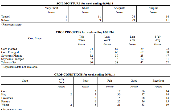 Kentucky Climate Summary
For the Period May 26, 2014 to June 1, 2014
Above Normal Temperatures and Much Below Normal Precipitation:
While the spring season will last another few weeks, weather conditions this past
period gave the impression of an early summer. High temperatures over nearly the
entire week stayed in the 80s with lows only dropping into the 60s. Some locations
even stayed in the 70s at night. The mild temperatures guided the way to a state
average of 5 degrees above normal. Looking at rainfall, Kentucky was dominated this
past week by a very moist and unstable air mass, more typical of summer. Scattered
showers and storms fired about every day during the afternoon and evening hours,
before tapering overnight. Localized heavy rainfall was the main threat with the
slow moving nature of any storms. The sporadic coverage of the storms amounted to a
very dry week across the Commonwealth. The state averaged just over a third of an
inch, which was the 4th driest week of 2014 thus far.
Temperatures for the period averaged 73 degrees across the state which was 5 degrees
warmer than normal and 6 degrees warmer than the previous period. High temperatures
averaged from 83 in the West to 82 in the East. Departure from normal high
temperatures ranged from 2 degrees warmer than normal in the West to 2 degrees
warmer than normal in the East. Low temperatures averaged from 67 degrees in the
West to 62 degrees in the East. Departure from normal low temperature ranged from 8
degrees warmer than normal in the West to 8 degrees warmer than normal in the East.
The extreme high temperature for the period was 90 degrees at PADUCAH ASOS and the
extreme low was 51 degrees at CYNTHIANA 8N.
Precipitation (liq. equ.) for the period totaled 0.36 inches statewide which was 0.76
inches below normal and 32% of normal. Precipitation totals by climate division, West
0.50 inches, Central 0.38 inches, Bluegrass 0.25 inches and East 0.32 inches, which
was 0.6, 0.78, 0.84 and 0.8 inches below normal. By station, precipitation totals
ranged from a low of 0.00 inches at BOWLING GREEN 5S to a high of 2.15 inches at BIG SANDY.
---
USDA's Kentucky Crop and Weather Report
Issued 4:00 P.M., May 27, 2014 8-14
Agricultural News: Kentucky experienced below normal precipitation and above average
temperatures over the past week. Precipitation for the week totaled 0.56 inches, 0.55
inches below normal. Temperatures averaged 68 degrees for the week, 2 degrees above
normal. Topsoil moisture was rated 4 percent short, 78 percent adequate and 18
percent surplus. Subsoil moisture was rated 4 percent short, 82 percent adequate and
14 percent surplus. Days suitable for fieldwork averaged 5.2 out of a possible seven.
Primary activities this week included planting corn, soybeans and tobacco, as well as
harvesting hay.
Crop planting progress benefitted from warmer and drier conditions. Strong storms hit
the state mid-week in some locations resulting in reports of wind and hail damage.
Bottom ground has dried out in some areas which allowed for those fields to be
planted. Producers continued spraying herbicides on corn and soybean fields and
applied nitrogen applications on early planted corn fields. A lot of hay was cut and
baled as conditions allowed, with many reports of yields from first cuttings being
down from last year.
Kentucky Climate Summary
For the Period May 26, 2014 to June 1, 2014
Above Normal Temperatures and Much Below Normal Precipitation:
While the spring season will last another few weeks, weather conditions this past
period gave the impression of an early summer. High temperatures over nearly the
entire week stayed in the 80s with lows only dropping into the 60s. Some locations
even stayed in the 70s at night. The mild temperatures guided the way to a state
average of 5 degrees above normal. Looking at rainfall, Kentucky was dominated this
past week by a very moist and unstable air mass, more typical of summer. Scattered
showers and storms fired about every day during the afternoon and evening hours,
before tapering overnight. Localized heavy rainfall was the main threat with the
slow moving nature of any storms. The sporadic coverage of the storms amounted to a
very dry week across the Commonwealth. The state averaged just over a third of an
inch, which was the 4th driest week of 2014 thus far.
Temperatures for the period averaged 73 degrees across the state which was 5 degrees
warmer than normal and 6 degrees warmer than the previous period. High temperatures
averaged from 83 in the West to 82 in the East. Departure from normal high
temperatures ranged from 2 degrees warmer than normal in the West to 2 degrees
warmer than normal in the East. Low temperatures averaged from 67 degrees in the
West to 62 degrees in the East. Departure from normal low temperature ranged from 8
degrees warmer than normal in the West to 8 degrees warmer than normal in the East.
The extreme high temperature for the period was 90 degrees at PADUCAH ASOS and the
extreme low was 51 degrees at CYNTHIANA 8N.
Precipitation (liq. equ.) for the period totaled 0.36 inches statewide which was 0.76
inches below normal and 32% of normal. Precipitation totals by climate division, West
0.50 inches, Central 0.38 inches, Bluegrass 0.25 inches and East 0.32 inches, which
was 0.6, 0.78, 0.84 and 0.8 inches below normal. By station, precipitation totals
ranged from a low of 0.00 inches at BOWLING GREEN 5S to a high of 2.15 inches at BIG SANDY.
---
USDA's Kentucky Crop and Weather Report
Issued 4:00 P.M., May 27, 2014 8-14
Agricultural News: Kentucky experienced below normal precipitation and above average
temperatures over the past week. Precipitation for the week totaled 0.56 inches, 0.55
inches below normal. Temperatures averaged 68 degrees for the week, 2 degrees above
normal. Topsoil moisture was rated 4 percent short, 78 percent adequate and 18
percent surplus. Subsoil moisture was rated 4 percent short, 82 percent adequate and
14 percent surplus. Days suitable for fieldwork averaged 5.2 out of a possible seven.
Primary activities this week included planting corn, soybeans and tobacco, as well as
harvesting hay.
Crop planting progress benefitted from warmer and drier conditions. Strong storms hit
the state mid-week in some locations resulting in reports of wind and hail damage.
Bottom ground has dried out in some areas which allowed for those fields to be
planted. Producers continued spraying herbicides on corn and soybean fields and
applied nitrogen applications on early planted corn fields. A lot of hay was cut and
baled as conditions allowed, with many reports of yields from first cuttings being
down from last year.
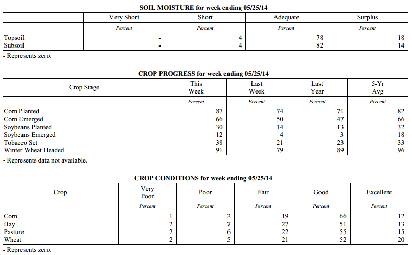 Kentucky Climate Summary
For the Period May 19, 2014 to May 25, 2014
Above Normal Temperatures and Below Normal Precipitation:
Mostly dry conditions moved back into the Commonwealth this past period. An upper
level ridge built into the Ohio Valley to start out the work week with surface high
pressure pushing east of the area. This kept skies mostly clear with a breezy
southerly wind at times. Summer-like temperatures returned to the area with highs
getting into the low to mid 80s Tuesday and Wednesday. Conditions then turned
unsettled as a broken line of strong to severe storms pushed through the region later
Wednesday and on into Thursday. There were numerous wind and hail reports, with one
in particular estimating hail in excess of 1.5 inches in Campbellsville. This was
really the only major rainfall event for the week as the state was on average 0.55
inches below normal for the period. High pressure then moved into the Ohio Valley for
the holiday weekend. This kept conditions dry with temperatures remaining around normal.
Temperatures for the period averaged 68 degrees across the state which was 2 degrees
warmer than normal and 6 degrees warmer than the previous period. High temperatures
averaged from 82 in the West to 78 in the East. Departure from normal high
temperatures ranged from 2 degrees warmer than normal in the West to near
normal in the East. Low temperatures averaged from 61 degrees in the West to 53
degrees in the East. Departure from normal low temperature ranged from 4 degrees
warmer than normal in the West to 1 degree warmer than normal in the East. The
extreme high temperature for the period was 90 degrees at PADUCAH ASOS and the
extreme low was 32 degrees at WILLIAMSBURG AWOS.
Precipitation (liq. equ.) for the period totaled 0.56 inches statewide which was 0.55
inches below normal and 50% of normal. Precipitation totals by climate division, West
0.29 inches, Central 0.34 inches, Bluegrass 0.99 inches and East 0.61 inches, which
was 0.81, 0.82, 0.08 and 0.51 inches below normal. By station, precipitation totals
ranged from a low of 0.00 inches at BENTON 4N to a high of 3.59 inches at MURRAY 1W.
---
USDA's Kentucky Crop and Weather Report
Issued 4:00 P.M., May 19, 2014 7-14
Agricultural News: Kentucky experienced below normal temperatures and above normal
precipitation over the past week. Precipitation for the week totaled 1.41 inches,
0.28 inches above normal. Temperatures averaged 61 degrees for the week, 3 degrees
below normal. Topsoil moisture was rated 2 percent short, 71 percent adequate and 27
percent surplus. Subsoil moisture was rated 3 percent short, 78 percent adequate, and
19 percent surplus. Days suitable for fieldwork averaged 3.0 out of a possible seven.
Primary activities this week included planting corn, soybeans and tobacco, along with
cutting of hay. Crop planting progress was hampered by rain and cool temperatures
throughout the week. Bottom land remains too wet to plant in most areas. Wet, cool
conditions have impacted emerged grains and hay crops. Crops could benefit from
warmer and drier conditions. Some corn ground has been replanted due to flooding.
Producers were spraying fungicides on wheat and herbicides on corn and soybean
fields. Tobacco transplant supplies were reported as 4 percent short, 90 percent
adequate, and 6 percent surplus. Fourteen percent of tobacco transplants were less
than 2 inches in height, with 47 percent between 2-4 inches, and 39 percent over 4
inches. Strawberries bloomed late due to prolonged winter and the freeze in mid-
April. Strawberry fruit size was reported as 9 percent below average, 72 percent
average, with 19 percent above average.
Kentucky Climate Summary
For the Period May 19, 2014 to May 25, 2014
Above Normal Temperatures and Below Normal Precipitation:
Mostly dry conditions moved back into the Commonwealth this past period. An upper
level ridge built into the Ohio Valley to start out the work week with surface high
pressure pushing east of the area. This kept skies mostly clear with a breezy
southerly wind at times. Summer-like temperatures returned to the area with highs
getting into the low to mid 80s Tuesday and Wednesday. Conditions then turned
unsettled as a broken line of strong to severe storms pushed through the region later
Wednesday and on into Thursday. There were numerous wind and hail reports, with one
in particular estimating hail in excess of 1.5 inches in Campbellsville. This was
really the only major rainfall event for the week as the state was on average 0.55
inches below normal for the period. High pressure then moved into the Ohio Valley for
the holiday weekend. This kept conditions dry with temperatures remaining around normal.
Temperatures for the period averaged 68 degrees across the state which was 2 degrees
warmer than normal and 6 degrees warmer than the previous period. High temperatures
averaged from 82 in the West to 78 in the East. Departure from normal high
temperatures ranged from 2 degrees warmer than normal in the West to near
normal in the East. Low temperatures averaged from 61 degrees in the West to 53
degrees in the East. Departure from normal low temperature ranged from 4 degrees
warmer than normal in the West to 1 degree warmer than normal in the East. The
extreme high temperature for the period was 90 degrees at PADUCAH ASOS and the
extreme low was 32 degrees at WILLIAMSBURG AWOS.
Precipitation (liq. equ.) for the period totaled 0.56 inches statewide which was 0.55
inches below normal and 50% of normal. Precipitation totals by climate division, West
0.29 inches, Central 0.34 inches, Bluegrass 0.99 inches and East 0.61 inches, which
was 0.81, 0.82, 0.08 and 0.51 inches below normal. By station, precipitation totals
ranged from a low of 0.00 inches at BENTON 4N to a high of 3.59 inches at MURRAY 1W.
---
USDA's Kentucky Crop and Weather Report
Issued 4:00 P.M., May 19, 2014 7-14
Agricultural News: Kentucky experienced below normal temperatures and above normal
precipitation over the past week. Precipitation for the week totaled 1.41 inches,
0.28 inches above normal. Temperatures averaged 61 degrees for the week, 3 degrees
below normal. Topsoil moisture was rated 2 percent short, 71 percent adequate and 27
percent surplus. Subsoil moisture was rated 3 percent short, 78 percent adequate, and
19 percent surplus. Days suitable for fieldwork averaged 3.0 out of a possible seven.
Primary activities this week included planting corn, soybeans and tobacco, along with
cutting of hay. Crop planting progress was hampered by rain and cool temperatures
throughout the week. Bottom land remains too wet to plant in most areas. Wet, cool
conditions have impacted emerged grains and hay crops. Crops could benefit from
warmer and drier conditions. Some corn ground has been replanted due to flooding.
Producers were spraying fungicides on wheat and herbicides on corn and soybean
fields. Tobacco transplant supplies were reported as 4 percent short, 90 percent
adequate, and 6 percent surplus. Fourteen percent of tobacco transplants were less
than 2 inches in height, with 47 percent between 2-4 inches, and 39 percent over 4
inches. Strawberries bloomed late due to prolonged winter and the freeze in mid-
April. Strawberry fruit size was reported as 9 percent below average, 72 percent
average, with 19 percent above average.
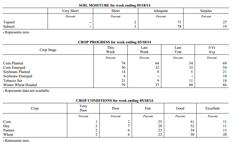 Kentucky Climate Summary
For the Period May 12, 2014 to May 18, 2014
Below Normal Temperatures and Above Normal Precipitation:
All eyes this past period were focused on a return to cool temperatures and the
threat of a late season spring frost. An upper level low then made headway into the
Ohio Valley Wednesday and through the remainder of the week with several disturbances
rotating around the system. The most prominent event came Wednesday with widespread
showers accompanied by some severe weather. Flash flooding and hail around 1 inch
were reported on several occasions. An EF2 tornado was even confirmed in Christian
County with estimated peak winds of 125 mph. The bigger story was the unseasonably
cool temperatures as highs Thursday through Saturday only peaked in the upper 50s to
mid 60s. Lows were also well below normal with temperatures dipping into the upper
30s to mid 40s for much of the state Friday and Saturday night. Saying this, some
low lying and sheltered locations across the Eastern half of Kentucky got into the
mid 30s, bringing patchy frost back into the picture. This frost event occurred at a
time when much of Kentucky had less than a 10% chance of seeing another 36 degree
reading based on the past 30 years of data.
Temperatures for the period averaged 61 degrees across the state which was 3 degrees
cooler than normal and 10 degrees cooler than the previous period. High temperatures
averaged from 69 in the West to 72 in the East. Departure from normal high
temperatures ranged from 8 degrees cooler than normal in the West to 4 degrees
cooler than normal in the East. Low temperatures averaged from 53 degrees in the
West to 52 degrees in the East. Departure from normal low temperature ranged from 2
degrees cooler than normal in the West to 3 degrees warmer than normal in the East.
The extreme high temperature for the period was 90 degrees at LOUISA 1S and the
extreme low was 33 degrees at PAINTSVILLE 4W.
Precipitation (liq. equ.) for the period totaled 1.41 inches statewide which was 0.28
inches above normal and 125% of normal. Precipitation totals by climate division,
West 1.71 inches, Central 1.81 inches, Bluegrass 1.40 inches and East 0.72 inches,
which was 0.53, 0.62, 0.33 and -0.37 inches respectively from normal. By station,
precipitation totals ranged from a low of 0.13 inches at LONDON to a high of 3.03
inches at CAMPBELLSVILLE 7W.
---
USDA's Kentucky Crop and Weather Report
Issued 4:00 P.M., May 12, 2014 6-14
Agricultural News: Kentucky experienced warmer conditions over the past week.
Precipitation for the week totaled 1.07 inches, 0.02 inches below normal.
Temperatures averaged 70 degrees for the week, 8 degrees above normal. Topsoil
moisture was rated 4 percent short, 74 percent adequate and 22 percent surplus.
Subsoil moisture was rated 4 percent short, 78 percent adequate, and 18 percent
surplus. Days suitable for fieldwork averaged 5.0 out of a possible seven. Primary
activities this week included planting corn, soybeans and tobacco, along with cutting
of alfalfa and wheat hay.
Crop planting made good progress early in the week, but raining conditions later in
the week put a hold on further advancement. The harsh conditions this past winter are
expected to impact both the quantity and quality of hay in many locations, especially
the first cutting of hay. Thinner stands and shorter height of hay are both
contributing factors to expectations of decreased hay yields from last year. Tobacco
transplant supplies were reported as 3 percent short, 91 percent adequate, and 6
percent surplus. Eighteen percent of tobacco transplants were under 2
inches, with 53 percent between 2-4 inches, and 29 percent over than 4 inches.
Kentucky Climate Summary
For the Period May 12, 2014 to May 18, 2014
Below Normal Temperatures and Above Normal Precipitation:
All eyes this past period were focused on a return to cool temperatures and the
threat of a late season spring frost. An upper level low then made headway into the
Ohio Valley Wednesday and through the remainder of the week with several disturbances
rotating around the system. The most prominent event came Wednesday with widespread
showers accompanied by some severe weather. Flash flooding and hail around 1 inch
were reported on several occasions. An EF2 tornado was even confirmed in Christian
County with estimated peak winds of 125 mph. The bigger story was the unseasonably
cool temperatures as highs Thursday through Saturday only peaked in the upper 50s to
mid 60s. Lows were also well below normal with temperatures dipping into the upper
30s to mid 40s for much of the state Friday and Saturday night. Saying this, some
low lying and sheltered locations across the Eastern half of Kentucky got into the
mid 30s, bringing patchy frost back into the picture. This frost event occurred at a
time when much of Kentucky had less than a 10% chance of seeing another 36 degree
reading based on the past 30 years of data.
Temperatures for the period averaged 61 degrees across the state which was 3 degrees
cooler than normal and 10 degrees cooler than the previous period. High temperatures
averaged from 69 in the West to 72 in the East. Departure from normal high
temperatures ranged from 8 degrees cooler than normal in the West to 4 degrees
cooler than normal in the East. Low temperatures averaged from 53 degrees in the
West to 52 degrees in the East. Departure from normal low temperature ranged from 2
degrees cooler than normal in the West to 3 degrees warmer than normal in the East.
The extreme high temperature for the period was 90 degrees at LOUISA 1S and the
extreme low was 33 degrees at PAINTSVILLE 4W.
Precipitation (liq. equ.) for the period totaled 1.41 inches statewide which was 0.28
inches above normal and 125% of normal. Precipitation totals by climate division,
West 1.71 inches, Central 1.81 inches, Bluegrass 1.40 inches and East 0.72 inches,
which was 0.53, 0.62, 0.33 and -0.37 inches respectively from normal. By station,
precipitation totals ranged from a low of 0.13 inches at LONDON to a high of 3.03
inches at CAMPBELLSVILLE 7W.
---
USDA's Kentucky Crop and Weather Report
Issued 4:00 P.M., May 12, 2014 6-14
Agricultural News: Kentucky experienced warmer conditions over the past week.
Precipitation for the week totaled 1.07 inches, 0.02 inches below normal.
Temperatures averaged 70 degrees for the week, 8 degrees above normal. Topsoil
moisture was rated 4 percent short, 74 percent adequate and 22 percent surplus.
Subsoil moisture was rated 4 percent short, 78 percent adequate, and 18 percent
surplus. Days suitable for fieldwork averaged 5.0 out of a possible seven. Primary
activities this week included planting corn, soybeans and tobacco, along with cutting
of alfalfa and wheat hay.
Crop planting made good progress early in the week, but raining conditions later in
the week put a hold on further advancement. The harsh conditions this past winter are
expected to impact both the quantity and quality of hay in many locations, especially
the first cutting of hay. Thinner stands and shorter height of hay are both
contributing factors to expectations of decreased hay yields from last year. Tobacco
transplant supplies were reported as 3 percent short, 91 percent adequate, and 6
percent surplus. Eighteen percent of tobacco transplants were under 2
inches, with 53 percent between 2-4 inches, and 29 percent over than 4 inches.
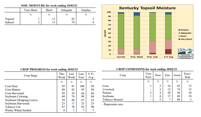 Kentucky Climate Summary
For the Period May 5, 2014 to May 11, 2014
Above Normal Temperatures and Near Normal Precipitation:
The Commonwealth got an early glimpse of summer this past period. The work week was
dominated by dry conditions and temperatures in the low to mid 80s. The warm
conditions helped push the Bluegrass State to a week where temperatures were on average
8 degrees above normal. This made it feel more like mid-June at times. Monday even
saw the mercury jump into the upper 80s with the city of Louisville recording a
temperature of 89 degrees at the airport. The good news was the moisture supply was
limited and kept humid conditions out of the picture. It was not until Friday and
into the weekend that the weather pattern became more active. Showers and storms
fired on multiple occasions with the passage of a couple frontal boundaries and upper
level disturbances. Some small hail was reported, with the state averaging just over
an inch through the three day period.
Temperatures for the period averaged 70 degrees across the state which was 8 degrees
warmer than normal and 10 degrees warmer than the previous period. High temperatures
averaged from 82 in the West to 82 in the East. Departure from normal high
temperatures ranged from 7 degrees warmer than normal in the West to 8 degrees
warmer than normal in the East. Low temperatures averaged from 62 degrees in the
West to 57 degrees in the East. Departure from normal low temperature ranged from 10
degrees warmer than normal in the West to 10 degrees warmer than normal in the
East. The extreme high temperature for the period was 89 degrees at LOUISVILLE APT
and the extreme low was 43 degrees at PAINTSVILLE 4W.
Precipitation (liq. equ.) for the period totaled 1.07 inches statewide which was 0.02
inches below normal and 98% of normal. Precipitation totals by climate division, West
0.97 inches, Central 1.70 inches, Bluegrass 0.88 inches and East 0.73 inches, which
was -0.19, 0.55, -0.13 and -0.32 inches respectively from normal. By station,
precipitation totals ranged from a low of 0.12 inches at ALBANY 1N to a high of 4.90
inches at FORT KNOX.
---
USDA's Kentucky Crop and Weather Report
Issued 4:00 P.M., May 5, 2014 5-14
Agricultural News: The Commonwealth experienced cool, wet weather conditions this
past week. Precipitation for the week totaled 2.62 inches, 1.55 inches above normal.
Temperatures averaged 60 degrees for the week, 2 degrees cooler than the previous
period. Topsoil moisture was rated 2 percent short, 64 percent adequate and 34
percent surplus. Subsoil moisture was rated 1 percent very short, 3 percent short, 71
percent adequate and 25 percent surplus. Days suitable for fieldwork averaged 2.5 out
of a possible seven. Primary activities this week included the cutting of some hay
and the spraying and cutting of wheat for forage. Weather conditions hampered
planting progress this week.
Grains and Oilseed: As of Sunday, May 4, 39 percent of the corn crop had been
planted, compared with 32 percent last year and the five year average of 52. Fifteen
percent of the corn crop has emerged, compared with 11 percent last year and the five
year average of 34 percent. Soybean planting is in the beginning stages with 2
percent planted, compared to 1 percent last year and the five year average of 8
percent. Six percent of winter wheat has headed compared to 22 percent last year and
the five year average of 47 percent. Winter wheat is in mostly good to fair condition
with 2 percent very poor, 8 percent poor, 25 percent fair, 50 percent good and 15
percent excellent. Average height of wheat was 16 inches.
Tobacco: Seeded tobacco transplants were reported in mostly good to excellent
condition with 1 percent very poor, 2 percent poor, 11 percent fair, 64 percent good,
and 22 percent excellent.
Pasture and Hay: Pasture condition was rated as 3 percent very poor, 8 percent poor,
27 percent fair, 49 percent good, and 13 percent excellent. Average height of alfalfa
was 15 inches at the end of the week. The projected average date for the first
cutting of alfalfa is May 14th.
Kentucky Climate Summary
For the Period April 28, 2014 to May 4, 2014
Near Normal Temperatures and Much Above Normal Precipitation:
Rain, rain, and more rain. An extremely wet pattern took control of the Commonwealth
this past period and resulted in the wettest week of 2014. Looking farther back, this
could even be seen as an understatement. The 2.62 inches that the state averaged was the
most in nearly two and a half years, going all the way back to early December of 2011.
Most of the rain fell over the mid-section of the work week as an upper level low slowly
meandered to the northeast. Multiple upper level disturbances sparked numerous rounds of
rainfall with some strong to severe activity mixed within. A weak tornado touched down
in Fulton County, in addition to multiple reports of funnels clouds in south central
Kentucky. After a very unsettled work week, the Commonwealth finally got a chance to dry
out over the weekend with milder temperatures in place. Behind mostly sunny skies, highs
got into the upper 70s to mid-80s for most of the area on Sunday. One exception was in
Western Kentucky where Paducah recorded a high of 88.
Temperatures for the period averaged 60 degrees across the state which was near
normal and 2 degrees cooler than the previous period. High temperatures
averaged from 70 in the West to 71 in the East. Departure from normal high
temperatures ranged from 4 degrees cooler than normal in the West to 2 degrees
cooler than normal in the East. Low temperatures averaged from 49 degrees in the
West to 50 degrees in the East. Departure from normal low temperature ranged from 1
degree cooler than normal in the West to 5 degrees warmer than normal in the East.
The extreme high temperature for the period was 88 degrees at PADUCAH ASOS and the
extreme low was 37 degrees at BURKESVILLE 3W.
Precipitation (liq. equ.) for the period totaled 2.62 inches statewide which was 1.55
inches above normal and 244% of normal. Precipitation totals by climate division,
West 2.71 inches, Central 2.83 inches, Bluegrass 2.62 inches and East 2.30 inches,
which was 1.5, 1.73, 1.63 and 1.3 inches above normal. By station, precipitation
totals ranged from a low of 0.84 inches at PIKEVILLE 13S to a high of 6.00
inches at HICKMAN 2E.
---
USDA's Kentucky Crop and Weather Report
Issued 4:00 P.M., April 28, 2014 4-14
Agricultural News: The Commonwealth experienced drier conditions over the past week.
Precipitation for the week totaled 0.65 inches, 0.39 inches below normal.
Temperatures averaged 62 degrees for the week, 4 degrees warmer than normal. Topsoil
moisture was rated 1 percent very short, 6 percent short, 72 percent adequate and 21
percent surplus. Subsoil moisture was rated 1 percent very short, 7 percent short, 75
percent adequate and 17 percent surplus. Days suitable for fieldwork averaged 5.2 out
of a possible seven. Primary activities this week included planting corn and applying
fertilizer. Fruit trees along with early set vegetables were adversely impacted by
the freeze on April 15.
Grains and Oilseed: As of Sunday, April 27, 32 percent of the corn crop had been
planted, compared with 23 percent last year and the five year average of 44. Seven
percent of the corn crop has emerged, compared with 4 percent last year and the five
year average of 22 percent. Soybean planting is in the beginning stages with 1
percent planted, compared to the five year average of 4 percent. One percent of
winter wheat has headed compared to 7 percent last year and the five year average of
28 percent. Winter wheat is in mostly good to fair condition with 2 percent very
poor, 8 percent poor, 26 percent fair, 49 percent good, and 15 percent excellent.
Average height of wheat was 13 inches.
Tobacco: Seeded tobacco transplants were reported in mostly good to excellent
condition with 2 percent poor, 12 percent fair, 66 percent good, and 20 percent
excellent.
Pasture and Hay: Pasture condition was rated as 3 percent very poor, 8 percent poor,
29 percent fair, 52 percent good, and 8 percent excellent. Average height of alfalfa
was 9 inches at the end of the week. The projected first cutting of alfalfa is May
14th .
Other: Freeze damage to apples was reported on 58 percent of crop with 31 percent
rated light, 20 percent moderate, and 7 percent severe. Freeze damage to peaches was
reported on 61 percent of crop with 17 percent rated light, 15 percent moderate, and
29 percent severe. Strawberry condition was rated as 2 percent very poor, 3 percent
poor, 20 percent fair, 64 percent good, and 11 percent excellent. Condition of
livestock was rated as 2 percent very poor, 5 percent poor, 22 percent fair, 61
percent good, and 10 percent excellent.
Kentucky Climate Summary
For the Period April 21, 2014 to April 27, 2014
Above Normal Temperatures and Below Normal Precipitation:
The Commonwealth has now gone 3 straight weeks with seeing below normal
precipitation. The state only saw a couple significant rounds of rainfall this
previous period with the first coming Thursday night and into Friday. A cold front
was dragged through the region with soaking rainfall in place. An upper level
disturbance then pushed into Western Kentucky late Sunday, sparking scattered showers
and storms across the region. The two events combined for a statewide average of
0.65 inches, which was nearly a half inch below normal. Temperature-wise, after a
rather cool previous period, temperatures rebounded to above normal readings for much
of the week. This kept a late-season frost out of the picture. Over the course of
the period, high temperatures got into the mid 70s to low 80s on multiple occasions.
Temperatures for the period averaged 62 degrees across the state which was 4 degrees
warmer than normal and 8 degrees warmer than the previous period. High temperatures
averaged from 75 in the West to 75 in the East. Departure from normal high
temperatures ranged from 3 degrees warmer than normal in the West to 4 degrees
warmer than normal in the East. Low temperatures averaged from 51 degrees in the
West to 47 degrees in the East. Departure from normal low temperature ranged from 3
degrees warmer than normal in the West to 5 degrees warmer than normal in the East.
The extreme high temperature for the period was 87 degrees at PEABODY and the extreme
low was 33 degrees at CYNTHIANA 8N.
Precipitation (liq. equ.) for the period totaled 0.65 inches statewide which was 0.39
inches below normal and 63% of normal. Precipitation totals by climate division, West
0.62 inches, Central 0.58 inches, Bluegrass 0.57 inches and East 0.83 inches, which
was 0.57, 0.47, 0.38 and 0.12 inches below normal. By station, precipitation totals
ranged from a low of 0.11 inches at MADISONVILLE 4S to a high of 1.72
inches at CALHOUN 5NW.
---
USDA's Kentucky Crop and Weather Report
Issued 4:00 P.M., April 21, 2014 3-14
Agricultural News: Snow and below freezing temperatures interrupted work in the
Commonwealth at the beginning of the week. However, temperatures increased over the
weekend. Precipitation for the week totaled 0.71 inches, 0.28 inches below normal.
Temperatures averaged 54 degrees, across the state, for the week, 2 degrees cooler
than normal and 6 degrees cooler then last period. The highest temperature this week
was 81 degrees at the MADISONVILLE 4S weather station, and the lowest temperature was
21 degrees at the PIKEVILLE 13S weather station. Topsoil moisture was rated 4 percent
short, 69 percent adequate and 27 percent surplus. Subsoil moisture was rated 4
percent short, 75 percent adequate and 21 percent surplus. Days suitable for
fieldwork averaged 4 out of a possible seven. Soils remain too wet for most
fieldwork. Primary activities this week included preparing fields for planting, and
applying fertilizer.
Crops: Ten percent of the corn crop had been planted, behind last year�s 14 percent
and the five-year average of 30 percent. Winter wheat continues to be concentrated in
the good to fair condition with 3 percent very poor, 9 percent poor, 25 percent fair,
48 percent good, and 15 percent excellent. Winter damage was reported on 40 percent
of wheat with 29 percent rated as light, 9 percent moderate, and 2 percent severe.
Tobacco: Ninety-two percent of the tobacco transplants had been seeded in comparison
to 90 percent last year and the five-year average of 90. Tobacco transplant
conditions were rated as 2 percent poor, 13 percent fair, 67 percent good and 18
percent excellent.
Pasture and Hay: Pasture condition was reported as 3 percent very poor, 10 percent
poor, 30 percent fair, 49 percent good, and 8 percent excellent. Though, many
livestock producers are still feeding their herds hay, the pasture growth in the
state is beginning to thrive.
Kentucky Climate Summary
For the Period April 14, 2014 to April 20, 2014
Below Normal Temperatures and Precipitation:
Winter and spring both made an appearance this past period with even a late season
snow event in the mix. A frontal boundary passed across the Commonwealth to start
off the work week, making for the only precipitation event for the period. Central
portions of the state saw the most with a half to one inch falling in most areas.
Breezy northwest flow picked up behind the front with some portions of the Bluegrass
and Eastern Kentucky even seeing some snowfall on Tuesday. One inch was recorded at
the National Weather Service in Jackson. According to the office, this resulted in
the longest snow season on record with a total of 174 days. High pressure then moved
overhead that night. Skies cleared and winds slackened, allowing for a widespread
freeze across the state. Most got down into the mid to upper 20s, but some sheltered
and low lying locations even dove into the low 20s. Kentucky then became under the
influence of high pressure for the majority of the time through Sunday. Temperatures
rebounded and surpassed seasonal norms over the weekend with most locations getting
into the upper 70s to low 80s by Sunday.
Temperatures for the period averaged 54 degrees across the state which was 2 degrees
cooler than normal and 6 degrees cooler than the previous period. High temperatures
averaged from 66 in the West to 68 in the East. Departure from normal high
temperatures ranged from 4 degrees cooler than normal in the West to 1 degree
cooler than normal in the East. Low temperatures averaged from 41 degrees in the
West to 43 degrees in the East. Departure from normal low temperature ranged from 5
degrees cooler than normal in the West to 2 degrees warmer than normal in the East.
The extreme high temperature for the period was 81 degrees at MADISONVILLE 4S and the
extreme low was 21 degrees at PIKEVILLE 13S.
Precipitation (liq. equ.) for the period totaled 0.71 inches statewide which was 0.28
inches below normal and 72% of normal. Precipitation totals by climate division, West
1.15 inches, Central 0.73 inches, Bluegrass 0.57 inches and East 0.38 inches, which
was 0.03, -0.26, -0.33 and -0.55 inches respectively from normal. By station,
precipitation totals ranged from a low of 0.08 inches at PIKEVILLE 13S to a high of
1.61 inches at MURRAY 1W.
---
USDA's Kentucky Crop and Weather Report
Issued 4:00 P.M., April 14, 2014 2-14
Agricultural News: The Commonwealth experienced drier conditions over the past week.
Precipitation for the week totaled 0.45 inches, 0.57 inches below normal.
Temperatures averaged 60 degrees for the week, 6 degrees warmer than normal. Topsoil
moisture was rated 1 percent short, 59 percent adequate and 40 percent surplus.
Subsoil moisture was rated 3 percent short, 70 percent adequate and 27 percent
surplus. Days suitable for fieldwork averaged 3.3 out of a possible seven. Soils
remain too wet for most fieldwork. Primary activities this week included preparing
farm equipment for planting, seeding pastures, applying fertilizer, and seeding
tobacco transplants. Twenty-seven percent of apples and 37 percent of peaches were in
full bloom. Some producers reported significant winter damage to peaches.
Crops: As of Sunday, April 13, 4 percent of the corn crop had been planted, behind
last year�s 6 percent and the five year average of 17. Farmers expect to plant corn
as soon as field conditions permit, and planting could make considerable progress
this week. Winter wheat is in mostly good to fair condition with 3 percent very poor,
8 percent poor, 29 percent fair, 47 percent good, and 13 percent excellent.
Tobacco: As of Sunday, April 13, 76 percent of the tobacco transplants had been
seeded compared with 84 percent last year and the five year average of 84.
Pasture and Hay: Pasture condition was reported as 4 percent very poor, 13 percent
poor, 32 percent fair, 45 percent good, and 6 percent excellent. Many operators were
still feeding hay and are hoping for rapid forage growth this week as hay supplies
are running low in some areas.
Kentucky Climate Summary
For the Period April 7, 2014 to April 13, 2014
Above Normal Temperatures and Below Normal Precipitation:
The Commonwealth got the chance to dry out this past period as the state saw an
average of just under a half inch of rainfall over the course of the week. This
activity was spread out over three systems with the brunt coming Monday as surface
low pressure pushed through the area. Much more focus was given to the return of warm
temperatures. Surface high pressure transitioned to the southeast on Thursday with
temperatures rising back into the 70s. After a weak front passed through the state on
Friday, skies became mostly sunny for the weekend with some of the warmest
temperatures of the year in place. Highs rose well into the 80s on Sunday behind a
breezy southwesterly flow pattern. Some locations even got into the upper 80s. This
had a great impact on soil temperatures across the Commonwealth with most locations
reporting the upper 50s to mid-60s at a 4 inch depth by the end of the day.
Temperatures for the period averaged 60 degrees across the state which was 6 degrees
warmer than normal and 4 degrees warmer than the previous period. High temperatures
averaged from 70 in the West to 72 in the East. Departure from normal high
temperatures ranged from 2 degrees warmer than normal in the West to 5 degrees
warmer than normal in the East. Low temperatures averaged from 49 degrees in the
West to 49 degrees in the East. Departure from normal low temperature ranged from 5
degrees warmer than normal in the West to 10 degrees warmer than normal in the
East. The extreme high temperature for the period was 87 degrees at LOUISA 1S and the
extreme low was 27 degrees at Fort Campbell.
Precipitation (liq. equ.) for the period totaled 0.45 inches statewide which was 0.57
inches below normal and 44% of normal. Precipitation totals by climate division, West
0.60 inches, Central 0.45 inches, Bluegrass 0.51 inches and East 0.22 inches, which
was 0.56, 0.59, 0.41 and 0.72 inches below normal. By station, precipitation totals
ranged from a low of 0.08 inches at BIG SANDY to a high of 1.71 inches at BENTON 4N.
---
USDA's Kentucky Crop and Weather Report
Issued 4:00 P.M., April 7, 2014 1-14
Agricultural News: The Commonwealth experienced extremely wet conditions over the
past week. Precipitation for the week totaled 2.19 inches, 1.2 inches above normal.
Temperatures averaged 56 degrees for the week, 4 degrees warmer than normal. Topsoil
moisture was rated 1 percent short, 50 percent adequate and 49 percent surplus.
Subsoil moisture was rated 3 percent short, 65 percent adequate and 32 percent
surplus. Days suitable for fieldwork averaged 2.9 out of a possible seven. Primary
activities this week included securing supplies and preparing farm equipment for
planting, applying fertilizer and herbicide to wheat, and plowing for tobacco when
the weather permitted.
Tobacco: As of Sunday, April 6, 65 percent of the greenhouse and plant bed seedings
had been completed compared with 72 percent last year and the five year average of
72.
Small Grains and Legumes: Fall seeded wheat was in mostly fair to good condition.
Winter damage for wheat was estimated at 39 percent light, 16 percent moderate, and 5
percent severe. Condition of the wheat crop was rated 3 percent very poor, 7 percent
poor, 32 percent fair, 46 percent good and 12 percent excellent. Alfalfa freeze damage
was reported at 37 percent light, 19 percent moderate, and 3 percent severe.
Pasture and Hay: Pasture condition was reported as 5 percent very poor, 17 percent
poor, 34 percent fair, 39 percent good, and 5 percent excellent. Hay and roughage
supplies were rated 5 percent very short, 16 percent short, 70 percent adequate, and
9 percent surplus. A number of farms have lost cattle due to the harsh winter.
Kentucky Climate Summary
For the Period March 31, 2014 to April 6, 2014
Above Normal Temperatures and Much Above Normal Precipitation:
An extremely wet pattern setup across the Lower Ohio Valley this past week, bringing
impressive rainfall totals across the area. Most of the activity was concentrated
over the second half of the work week as a series of disturbances passed through the
Commonwealth. The state averaged 2.19 inches over the course of week, which was over
an inch above normal. This was although small in comparison to some areas of North
Central and Western Kentucky that saw in excess of 4 to 6 inches. This would
actually be more than the normal amount of precipitation seen over the entire month
of April. Accompanying the wet conditions were mild temperatures for the work week.
Highs got into the 70s numerous times, with some locations even getting into the low
80s. Canadian high pressure then pushed into the area for the weekend with cooler
conditions in place.
Temperatures for the period averaged 56 degrees across the state which was 4 degrees
warmer than normal and 14 degrees warmer than the previous period. High temperatures
averaged from 69 in the West to 71 in the East. Departure from normal high
temperatures ranged from 4 degrees warmer than normal in the West to 7 degrees
warmer than normal in the East. Low temperatures averaged from 46 degrees in the
West to 44 degrees in the East. Departure from normal low temperature ranged from 4
degrees warmer than normal in the West to 7 degrees warmer than normal in the East.
The extreme high temperature for the period was 83 degrees at LOUISA 1S and the
extreme low was 25 degrees at PAINTSVILLE 4W.
Precipitation (liq. equ.) for the period totaled 2.19 inches statewide which was 1.2
inches above normal and 220% of normal. Precipitation totals by climate division,
West 2.57 inches, Central 2.36 inches, Bluegrass 2.54 inches and East 1.31 inches,
which was 1.48, 1.32, 1.64 and 0.36 inches above normal. By station, precipitation
totals ranged from a low of 0.78 inches at MIDDLESBORO AWOS to a high of 5.60
inches at MORGANFIELD 4E.
---
Kentucky Climate Summary
For the Period March 24, 2014 to March 30, 2014
Well Below Normal Temperatures and Above Normal Precipitation:
Wet conditions moved back into the Bluegrass State this past period with even a
couple late-season snow events in the mix. Activity started over the course of
Monday night and into Tuesday as a couple upper level disturbances passed through the
region. The second round was the most prominent with scattered snow showers in place
as temperatures cooled throughout the day. The good news is that accumulations were
confined to grassy surfaces and were short-lived, but increased winds made for poor
visibilities at times. Below is a couple pictures taken Tuesday at the University of
Kentucky. The first was taken in the morning with the first round of snow showers.
The second came in the afternoon when winds picked up and visibility was reduced
drastically.
Kentucky Climate Summary
For the Period May 5, 2014 to May 11, 2014
Above Normal Temperatures and Near Normal Precipitation:
The Commonwealth got an early glimpse of summer this past period. The work week was
dominated by dry conditions and temperatures in the low to mid 80s. The warm
conditions helped push the Bluegrass State to a week where temperatures were on average
8 degrees above normal. This made it feel more like mid-June at times. Monday even
saw the mercury jump into the upper 80s with the city of Louisville recording a
temperature of 89 degrees at the airport. The good news was the moisture supply was
limited and kept humid conditions out of the picture. It was not until Friday and
into the weekend that the weather pattern became more active. Showers and storms
fired on multiple occasions with the passage of a couple frontal boundaries and upper
level disturbances. Some small hail was reported, with the state averaging just over
an inch through the three day period.
Temperatures for the period averaged 70 degrees across the state which was 8 degrees
warmer than normal and 10 degrees warmer than the previous period. High temperatures
averaged from 82 in the West to 82 in the East. Departure from normal high
temperatures ranged from 7 degrees warmer than normal in the West to 8 degrees
warmer than normal in the East. Low temperatures averaged from 62 degrees in the
West to 57 degrees in the East. Departure from normal low temperature ranged from 10
degrees warmer than normal in the West to 10 degrees warmer than normal in the
East. The extreme high temperature for the period was 89 degrees at LOUISVILLE APT
and the extreme low was 43 degrees at PAINTSVILLE 4W.
Precipitation (liq. equ.) for the period totaled 1.07 inches statewide which was 0.02
inches below normal and 98% of normal. Precipitation totals by climate division, West
0.97 inches, Central 1.70 inches, Bluegrass 0.88 inches and East 0.73 inches, which
was -0.19, 0.55, -0.13 and -0.32 inches respectively from normal. By station,
precipitation totals ranged from a low of 0.12 inches at ALBANY 1N to a high of 4.90
inches at FORT KNOX.
---
USDA's Kentucky Crop and Weather Report
Issued 4:00 P.M., May 5, 2014 5-14
Agricultural News: The Commonwealth experienced cool, wet weather conditions this
past week. Precipitation for the week totaled 2.62 inches, 1.55 inches above normal.
Temperatures averaged 60 degrees for the week, 2 degrees cooler than the previous
period. Topsoil moisture was rated 2 percent short, 64 percent adequate and 34
percent surplus. Subsoil moisture was rated 1 percent very short, 3 percent short, 71
percent adequate and 25 percent surplus. Days suitable for fieldwork averaged 2.5 out
of a possible seven. Primary activities this week included the cutting of some hay
and the spraying and cutting of wheat for forage. Weather conditions hampered
planting progress this week.
Grains and Oilseed: As of Sunday, May 4, 39 percent of the corn crop had been
planted, compared with 32 percent last year and the five year average of 52. Fifteen
percent of the corn crop has emerged, compared with 11 percent last year and the five
year average of 34 percent. Soybean planting is in the beginning stages with 2
percent planted, compared to 1 percent last year and the five year average of 8
percent. Six percent of winter wheat has headed compared to 22 percent last year and
the five year average of 47 percent. Winter wheat is in mostly good to fair condition
with 2 percent very poor, 8 percent poor, 25 percent fair, 50 percent good and 15
percent excellent. Average height of wheat was 16 inches.
Tobacco: Seeded tobacco transplants were reported in mostly good to excellent
condition with 1 percent very poor, 2 percent poor, 11 percent fair, 64 percent good,
and 22 percent excellent.
Pasture and Hay: Pasture condition was rated as 3 percent very poor, 8 percent poor,
27 percent fair, 49 percent good, and 13 percent excellent. Average height of alfalfa
was 15 inches at the end of the week. The projected average date for the first
cutting of alfalfa is May 14th.
Kentucky Climate Summary
For the Period April 28, 2014 to May 4, 2014
Near Normal Temperatures and Much Above Normal Precipitation:
Rain, rain, and more rain. An extremely wet pattern took control of the Commonwealth
this past period and resulted in the wettest week of 2014. Looking farther back, this
could even be seen as an understatement. The 2.62 inches that the state averaged was the
most in nearly two and a half years, going all the way back to early December of 2011.
Most of the rain fell over the mid-section of the work week as an upper level low slowly
meandered to the northeast. Multiple upper level disturbances sparked numerous rounds of
rainfall with some strong to severe activity mixed within. A weak tornado touched down
in Fulton County, in addition to multiple reports of funnels clouds in south central
Kentucky. After a very unsettled work week, the Commonwealth finally got a chance to dry
out over the weekend with milder temperatures in place. Behind mostly sunny skies, highs
got into the upper 70s to mid-80s for most of the area on Sunday. One exception was in
Western Kentucky where Paducah recorded a high of 88.
Temperatures for the period averaged 60 degrees across the state which was near
normal and 2 degrees cooler than the previous period. High temperatures
averaged from 70 in the West to 71 in the East. Departure from normal high
temperatures ranged from 4 degrees cooler than normal in the West to 2 degrees
cooler than normal in the East. Low temperatures averaged from 49 degrees in the
West to 50 degrees in the East. Departure from normal low temperature ranged from 1
degree cooler than normal in the West to 5 degrees warmer than normal in the East.
The extreme high temperature for the period was 88 degrees at PADUCAH ASOS and the
extreme low was 37 degrees at BURKESVILLE 3W.
Precipitation (liq. equ.) for the period totaled 2.62 inches statewide which was 1.55
inches above normal and 244% of normal. Precipitation totals by climate division,
West 2.71 inches, Central 2.83 inches, Bluegrass 2.62 inches and East 2.30 inches,
which was 1.5, 1.73, 1.63 and 1.3 inches above normal. By station, precipitation
totals ranged from a low of 0.84 inches at PIKEVILLE 13S to a high of 6.00
inches at HICKMAN 2E.
---
USDA's Kentucky Crop and Weather Report
Issued 4:00 P.M., April 28, 2014 4-14
Agricultural News: The Commonwealth experienced drier conditions over the past week.
Precipitation for the week totaled 0.65 inches, 0.39 inches below normal.
Temperatures averaged 62 degrees for the week, 4 degrees warmer than normal. Topsoil
moisture was rated 1 percent very short, 6 percent short, 72 percent adequate and 21
percent surplus. Subsoil moisture was rated 1 percent very short, 7 percent short, 75
percent adequate and 17 percent surplus. Days suitable for fieldwork averaged 5.2 out
of a possible seven. Primary activities this week included planting corn and applying
fertilizer. Fruit trees along with early set vegetables were adversely impacted by
the freeze on April 15.
Grains and Oilseed: As of Sunday, April 27, 32 percent of the corn crop had been
planted, compared with 23 percent last year and the five year average of 44. Seven
percent of the corn crop has emerged, compared with 4 percent last year and the five
year average of 22 percent. Soybean planting is in the beginning stages with 1
percent planted, compared to the five year average of 4 percent. One percent of
winter wheat has headed compared to 7 percent last year and the five year average of
28 percent. Winter wheat is in mostly good to fair condition with 2 percent very
poor, 8 percent poor, 26 percent fair, 49 percent good, and 15 percent excellent.
Average height of wheat was 13 inches.
Tobacco: Seeded tobacco transplants were reported in mostly good to excellent
condition with 2 percent poor, 12 percent fair, 66 percent good, and 20 percent
excellent.
Pasture and Hay: Pasture condition was rated as 3 percent very poor, 8 percent poor,
29 percent fair, 52 percent good, and 8 percent excellent. Average height of alfalfa
was 9 inches at the end of the week. The projected first cutting of alfalfa is May
14th .
Other: Freeze damage to apples was reported on 58 percent of crop with 31 percent
rated light, 20 percent moderate, and 7 percent severe. Freeze damage to peaches was
reported on 61 percent of crop with 17 percent rated light, 15 percent moderate, and
29 percent severe. Strawberry condition was rated as 2 percent very poor, 3 percent
poor, 20 percent fair, 64 percent good, and 11 percent excellent. Condition of
livestock was rated as 2 percent very poor, 5 percent poor, 22 percent fair, 61
percent good, and 10 percent excellent.
Kentucky Climate Summary
For the Period April 21, 2014 to April 27, 2014
Above Normal Temperatures and Below Normal Precipitation:
The Commonwealth has now gone 3 straight weeks with seeing below normal
precipitation. The state only saw a couple significant rounds of rainfall this
previous period with the first coming Thursday night and into Friday. A cold front
was dragged through the region with soaking rainfall in place. An upper level
disturbance then pushed into Western Kentucky late Sunday, sparking scattered showers
and storms across the region. The two events combined for a statewide average of
0.65 inches, which was nearly a half inch below normal. Temperature-wise, after a
rather cool previous period, temperatures rebounded to above normal readings for much
of the week. This kept a late-season frost out of the picture. Over the course of
the period, high temperatures got into the mid 70s to low 80s on multiple occasions.
Temperatures for the period averaged 62 degrees across the state which was 4 degrees
warmer than normal and 8 degrees warmer than the previous period. High temperatures
averaged from 75 in the West to 75 in the East. Departure from normal high
temperatures ranged from 3 degrees warmer than normal in the West to 4 degrees
warmer than normal in the East. Low temperatures averaged from 51 degrees in the
West to 47 degrees in the East. Departure from normal low temperature ranged from 3
degrees warmer than normal in the West to 5 degrees warmer than normal in the East.
The extreme high temperature for the period was 87 degrees at PEABODY and the extreme
low was 33 degrees at CYNTHIANA 8N.
Precipitation (liq. equ.) for the period totaled 0.65 inches statewide which was 0.39
inches below normal and 63% of normal. Precipitation totals by climate division, West
0.62 inches, Central 0.58 inches, Bluegrass 0.57 inches and East 0.83 inches, which
was 0.57, 0.47, 0.38 and 0.12 inches below normal. By station, precipitation totals
ranged from a low of 0.11 inches at MADISONVILLE 4S to a high of 1.72
inches at CALHOUN 5NW.
---
USDA's Kentucky Crop and Weather Report
Issued 4:00 P.M., April 21, 2014 3-14
Agricultural News: Snow and below freezing temperatures interrupted work in the
Commonwealth at the beginning of the week. However, temperatures increased over the
weekend. Precipitation for the week totaled 0.71 inches, 0.28 inches below normal.
Temperatures averaged 54 degrees, across the state, for the week, 2 degrees cooler
than normal and 6 degrees cooler then last period. The highest temperature this week
was 81 degrees at the MADISONVILLE 4S weather station, and the lowest temperature was
21 degrees at the PIKEVILLE 13S weather station. Topsoil moisture was rated 4 percent
short, 69 percent adequate and 27 percent surplus. Subsoil moisture was rated 4
percent short, 75 percent adequate and 21 percent surplus. Days suitable for
fieldwork averaged 4 out of a possible seven. Soils remain too wet for most
fieldwork. Primary activities this week included preparing fields for planting, and
applying fertilizer.
Crops: Ten percent of the corn crop had been planted, behind last year�s 14 percent
and the five-year average of 30 percent. Winter wheat continues to be concentrated in
the good to fair condition with 3 percent very poor, 9 percent poor, 25 percent fair,
48 percent good, and 15 percent excellent. Winter damage was reported on 40 percent
of wheat with 29 percent rated as light, 9 percent moderate, and 2 percent severe.
Tobacco: Ninety-two percent of the tobacco transplants had been seeded in comparison
to 90 percent last year and the five-year average of 90. Tobacco transplant
conditions were rated as 2 percent poor, 13 percent fair, 67 percent good and 18
percent excellent.
Pasture and Hay: Pasture condition was reported as 3 percent very poor, 10 percent
poor, 30 percent fair, 49 percent good, and 8 percent excellent. Though, many
livestock producers are still feeding their herds hay, the pasture growth in the
state is beginning to thrive.
Kentucky Climate Summary
For the Period April 14, 2014 to April 20, 2014
Below Normal Temperatures and Precipitation:
Winter and spring both made an appearance this past period with even a late season
snow event in the mix. A frontal boundary passed across the Commonwealth to start
off the work week, making for the only precipitation event for the period. Central
portions of the state saw the most with a half to one inch falling in most areas.
Breezy northwest flow picked up behind the front with some portions of the Bluegrass
and Eastern Kentucky even seeing some snowfall on Tuesday. One inch was recorded at
the National Weather Service in Jackson. According to the office, this resulted in
the longest snow season on record with a total of 174 days. High pressure then moved
overhead that night. Skies cleared and winds slackened, allowing for a widespread
freeze across the state. Most got down into the mid to upper 20s, but some sheltered
and low lying locations even dove into the low 20s. Kentucky then became under the
influence of high pressure for the majority of the time through Sunday. Temperatures
rebounded and surpassed seasonal norms over the weekend with most locations getting
into the upper 70s to low 80s by Sunday.
Temperatures for the period averaged 54 degrees across the state which was 2 degrees
cooler than normal and 6 degrees cooler than the previous period. High temperatures
averaged from 66 in the West to 68 in the East. Departure from normal high
temperatures ranged from 4 degrees cooler than normal in the West to 1 degree
cooler than normal in the East. Low temperatures averaged from 41 degrees in the
West to 43 degrees in the East. Departure from normal low temperature ranged from 5
degrees cooler than normal in the West to 2 degrees warmer than normal in the East.
The extreme high temperature for the period was 81 degrees at MADISONVILLE 4S and the
extreme low was 21 degrees at PIKEVILLE 13S.
Precipitation (liq. equ.) for the period totaled 0.71 inches statewide which was 0.28
inches below normal and 72% of normal. Precipitation totals by climate division, West
1.15 inches, Central 0.73 inches, Bluegrass 0.57 inches and East 0.38 inches, which
was 0.03, -0.26, -0.33 and -0.55 inches respectively from normal. By station,
precipitation totals ranged from a low of 0.08 inches at PIKEVILLE 13S to a high of
1.61 inches at MURRAY 1W.
---
USDA's Kentucky Crop and Weather Report
Issued 4:00 P.M., April 14, 2014 2-14
Agricultural News: The Commonwealth experienced drier conditions over the past week.
Precipitation for the week totaled 0.45 inches, 0.57 inches below normal.
Temperatures averaged 60 degrees for the week, 6 degrees warmer than normal. Topsoil
moisture was rated 1 percent short, 59 percent adequate and 40 percent surplus.
Subsoil moisture was rated 3 percent short, 70 percent adequate and 27 percent
surplus. Days suitable for fieldwork averaged 3.3 out of a possible seven. Soils
remain too wet for most fieldwork. Primary activities this week included preparing
farm equipment for planting, seeding pastures, applying fertilizer, and seeding
tobacco transplants. Twenty-seven percent of apples and 37 percent of peaches were in
full bloom. Some producers reported significant winter damage to peaches.
Crops: As of Sunday, April 13, 4 percent of the corn crop had been planted, behind
last year�s 6 percent and the five year average of 17. Farmers expect to plant corn
as soon as field conditions permit, and planting could make considerable progress
this week. Winter wheat is in mostly good to fair condition with 3 percent very poor,
8 percent poor, 29 percent fair, 47 percent good, and 13 percent excellent.
Tobacco: As of Sunday, April 13, 76 percent of the tobacco transplants had been
seeded compared with 84 percent last year and the five year average of 84.
Pasture and Hay: Pasture condition was reported as 4 percent very poor, 13 percent
poor, 32 percent fair, 45 percent good, and 6 percent excellent. Many operators were
still feeding hay and are hoping for rapid forage growth this week as hay supplies
are running low in some areas.
Kentucky Climate Summary
For the Period April 7, 2014 to April 13, 2014
Above Normal Temperatures and Below Normal Precipitation:
The Commonwealth got the chance to dry out this past period as the state saw an
average of just under a half inch of rainfall over the course of the week. This
activity was spread out over three systems with the brunt coming Monday as surface
low pressure pushed through the area. Much more focus was given to the return of warm
temperatures. Surface high pressure transitioned to the southeast on Thursday with
temperatures rising back into the 70s. After a weak front passed through the state on
Friday, skies became mostly sunny for the weekend with some of the warmest
temperatures of the year in place. Highs rose well into the 80s on Sunday behind a
breezy southwesterly flow pattern. Some locations even got into the upper 80s. This
had a great impact on soil temperatures across the Commonwealth with most locations
reporting the upper 50s to mid-60s at a 4 inch depth by the end of the day.
Temperatures for the period averaged 60 degrees across the state which was 6 degrees
warmer than normal and 4 degrees warmer than the previous period. High temperatures
averaged from 70 in the West to 72 in the East. Departure from normal high
temperatures ranged from 2 degrees warmer than normal in the West to 5 degrees
warmer than normal in the East. Low temperatures averaged from 49 degrees in the
West to 49 degrees in the East. Departure from normal low temperature ranged from 5
degrees warmer than normal in the West to 10 degrees warmer than normal in the
East. The extreme high temperature for the period was 87 degrees at LOUISA 1S and the
extreme low was 27 degrees at Fort Campbell.
Precipitation (liq. equ.) for the period totaled 0.45 inches statewide which was 0.57
inches below normal and 44% of normal. Precipitation totals by climate division, West
0.60 inches, Central 0.45 inches, Bluegrass 0.51 inches and East 0.22 inches, which
was 0.56, 0.59, 0.41 and 0.72 inches below normal. By station, precipitation totals
ranged from a low of 0.08 inches at BIG SANDY to a high of 1.71 inches at BENTON 4N.
---
USDA's Kentucky Crop and Weather Report
Issued 4:00 P.M., April 7, 2014 1-14
Agricultural News: The Commonwealth experienced extremely wet conditions over the
past week. Precipitation for the week totaled 2.19 inches, 1.2 inches above normal.
Temperatures averaged 56 degrees for the week, 4 degrees warmer than normal. Topsoil
moisture was rated 1 percent short, 50 percent adequate and 49 percent surplus.
Subsoil moisture was rated 3 percent short, 65 percent adequate and 32 percent
surplus. Days suitable for fieldwork averaged 2.9 out of a possible seven. Primary
activities this week included securing supplies and preparing farm equipment for
planting, applying fertilizer and herbicide to wheat, and plowing for tobacco when
the weather permitted.
Tobacco: As of Sunday, April 6, 65 percent of the greenhouse and plant bed seedings
had been completed compared with 72 percent last year and the five year average of
72.
Small Grains and Legumes: Fall seeded wheat was in mostly fair to good condition.
Winter damage for wheat was estimated at 39 percent light, 16 percent moderate, and 5
percent severe. Condition of the wheat crop was rated 3 percent very poor, 7 percent
poor, 32 percent fair, 46 percent good and 12 percent excellent. Alfalfa freeze damage
was reported at 37 percent light, 19 percent moderate, and 3 percent severe.
Pasture and Hay: Pasture condition was reported as 5 percent very poor, 17 percent
poor, 34 percent fair, 39 percent good, and 5 percent excellent. Hay and roughage
supplies were rated 5 percent very short, 16 percent short, 70 percent adequate, and
9 percent surplus. A number of farms have lost cattle due to the harsh winter.
Kentucky Climate Summary
For the Period March 31, 2014 to April 6, 2014
Above Normal Temperatures and Much Above Normal Precipitation:
An extremely wet pattern setup across the Lower Ohio Valley this past week, bringing
impressive rainfall totals across the area. Most of the activity was concentrated
over the second half of the work week as a series of disturbances passed through the
Commonwealth. The state averaged 2.19 inches over the course of week, which was over
an inch above normal. This was although small in comparison to some areas of North
Central and Western Kentucky that saw in excess of 4 to 6 inches. This would
actually be more than the normal amount of precipitation seen over the entire month
of April. Accompanying the wet conditions were mild temperatures for the work week.
Highs got into the 70s numerous times, with some locations even getting into the low
80s. Canadian high pressure then pushed into the area for the weekend with cooler
conditions in place.
Temperatures for the period averaged 56 degrees across the state which was 4 degrees
warmer than normal and 14 degrees warmer than the previous period. High temperatures
averaged from 69 in the West to 71 in the East. Departure from normal high
temperatures ranged from 4 degrees warmer than normal in the West to 7 degrees
warmer than normal in the East. Low temperatures averaged from 46 degrees in the
West to 44 degrees in the East. Departure from normal low temperature ranged from 4
degrees warmer than normal in the West to 7 degrees warmer than normal in the East.
The extreme high temperature for the period was 83 degrees at LOUISA 1S and the
extreme low was 25 degrees at PAINTSVILLE 4W.
Precipitation (liq. equ.) for the period totaled 2.19 inches statewide which was 1.2
inches above normal and 220% of normal. Precipitation totals by climate division,
West 2.57 inches, Central 2.36 inches, Bluegrass 2.54 inches and East 1.31 inches,
which was 1.48, 1.32, 1.64 and 0.36 inches above normal. By station, precipitation
totals ranged from a low of 0.78 inches at MIDDLESBORO AWOS to a high of 5.60
inches at MORGANFIELD 4E.
---
Kentucky Climate Summary
For the Period March 24, 2014 to March 30, 2014
Well Below Normal Temperatures and Above Normal Precipitation:
Wet conditions moved back into the Bluegrass State this past period with even a
couple late-season snow events in the mix. Activity started over the course of
Monday night and into Tuesday as a couple upper level disturbances passed through the
region. The second round was the most prominent with scattered snow showers in place
as temperatures cooled throughout the day. The good news is that accumulations were
confined to grassy surfaces and were short-lived, but increased winds made for poor
visibilities at times. Below is a couple pictures taken Tuesday at the University of
Kentucky. The first was taken in the morning with the first round of snow showers.
The second came in the afternoon when winds picked up and visibility was reduced
drastically.
Morning of 8/25 |
Afternoon of 8/25 |