
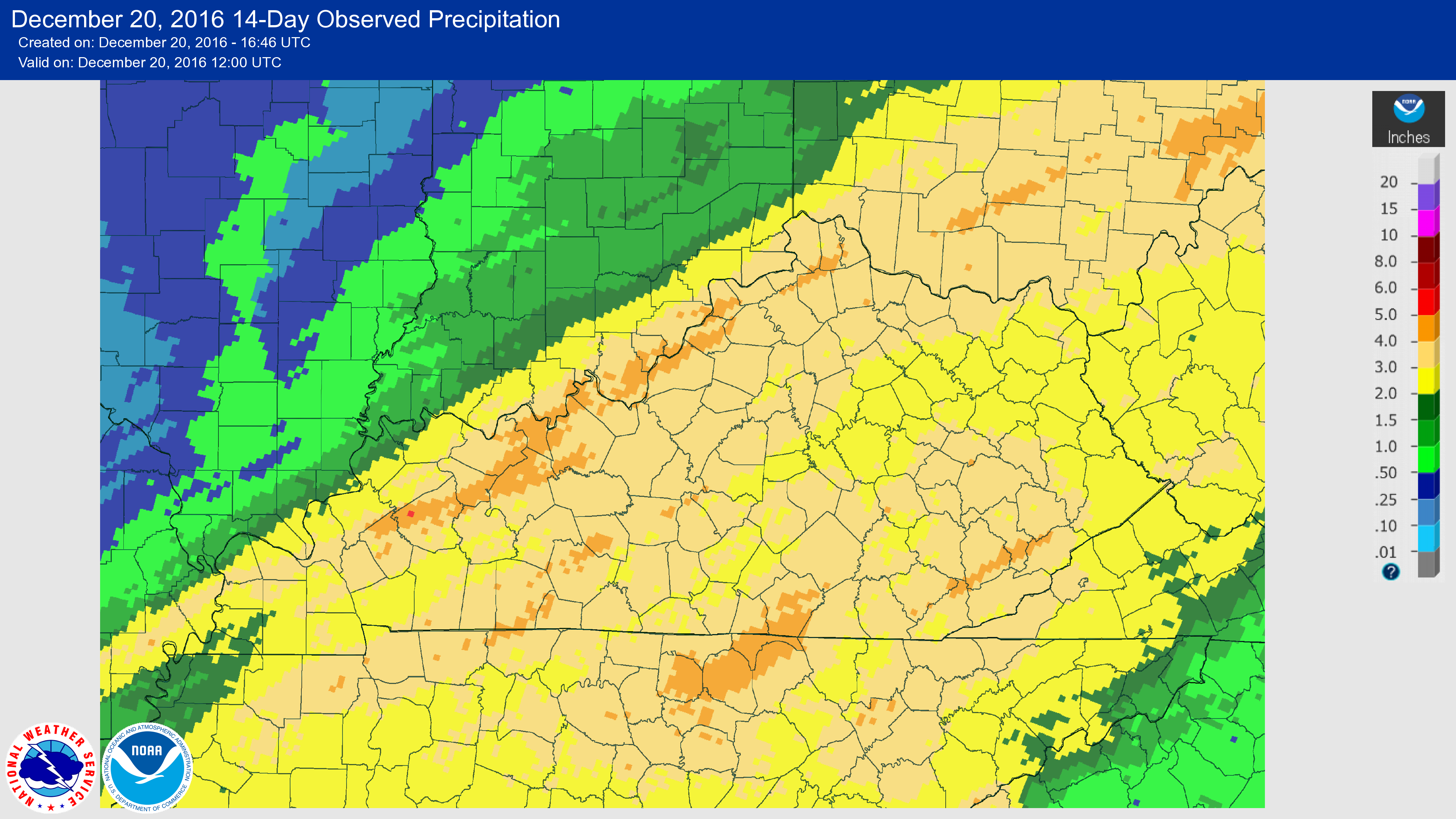
12/20/2016 Drought Update:
|
|
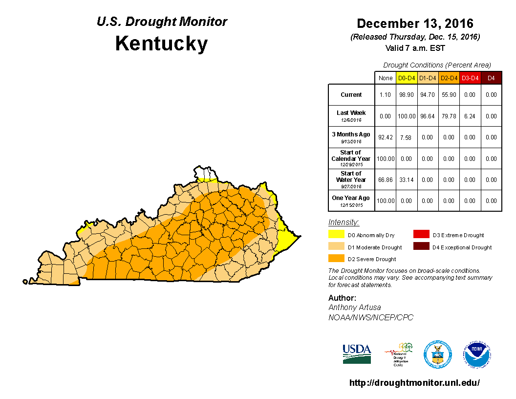
12/14/2016 Drought Update:
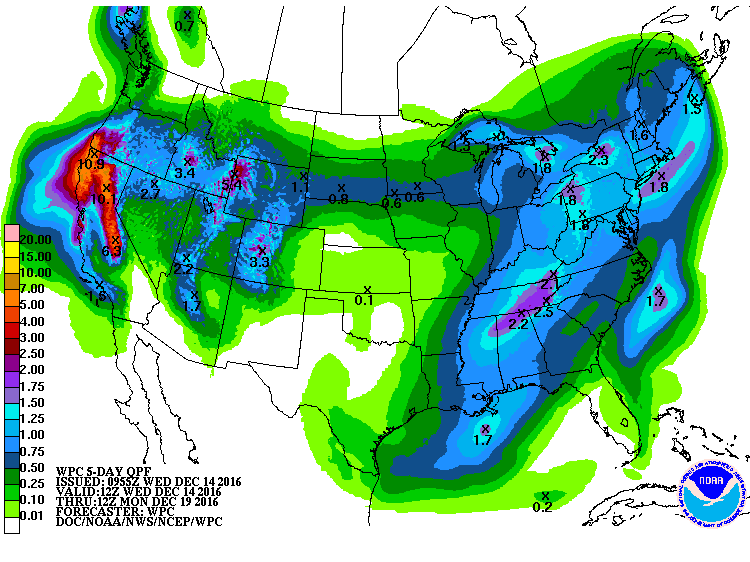
The pattern seems to have shifted recently with much more in the way of opportunities for rainfall. Over the past couple weeks, the state has averaged 2.23 inches according to data with the Ag Weather Center, which is slightly above normal. The latest update to the US Drought Monitor (Figure 1) reduced the area of 'Extreme' drought down to a little over 6%. The active pattern looks to continue into the upcoming weekend with over an inch in the forecast (Figure 2) for the majority of the state. Outlooks also point toward a better chance for above normal precipitation over the second half of December.
|
|
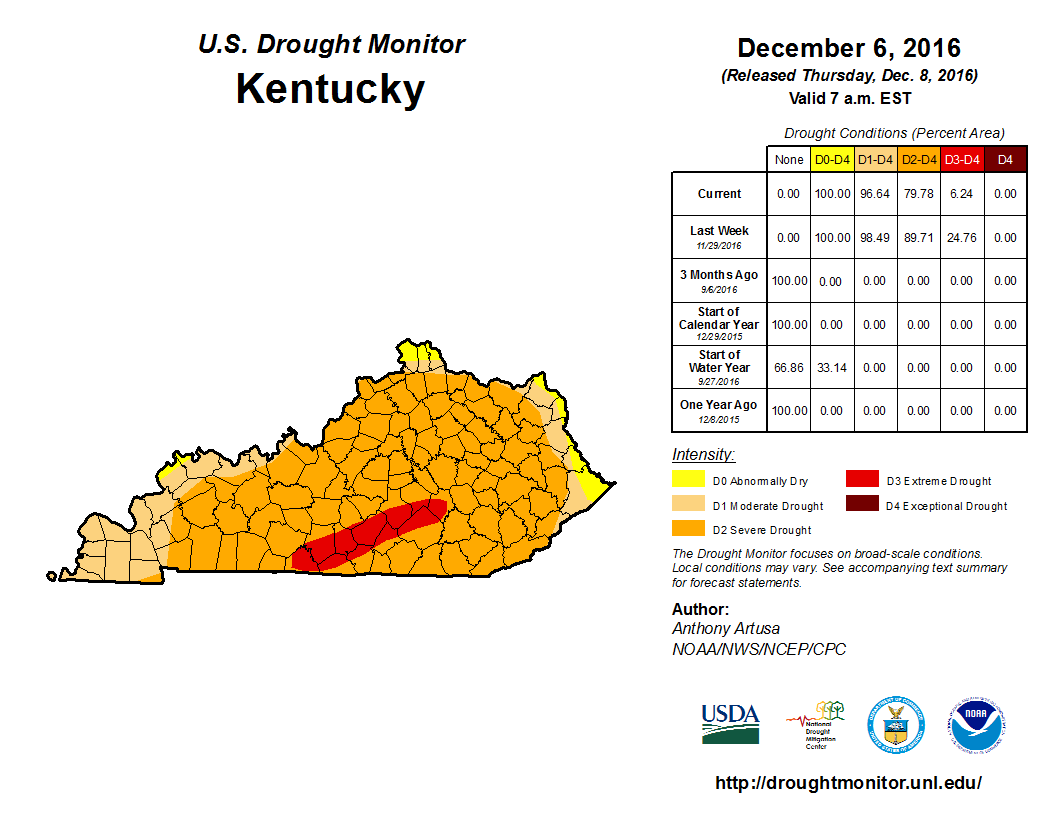
12/02/2016 Drought Update:
The Kentucky Department of Agriculture had a press release on Wednesday (November 30th) discussing that some Kentucky farmers may be elgible for drought aid. This comes as 10 counties in the southeastern side of the state are now under a agricultural drought declaration. More information can be found in the article below.
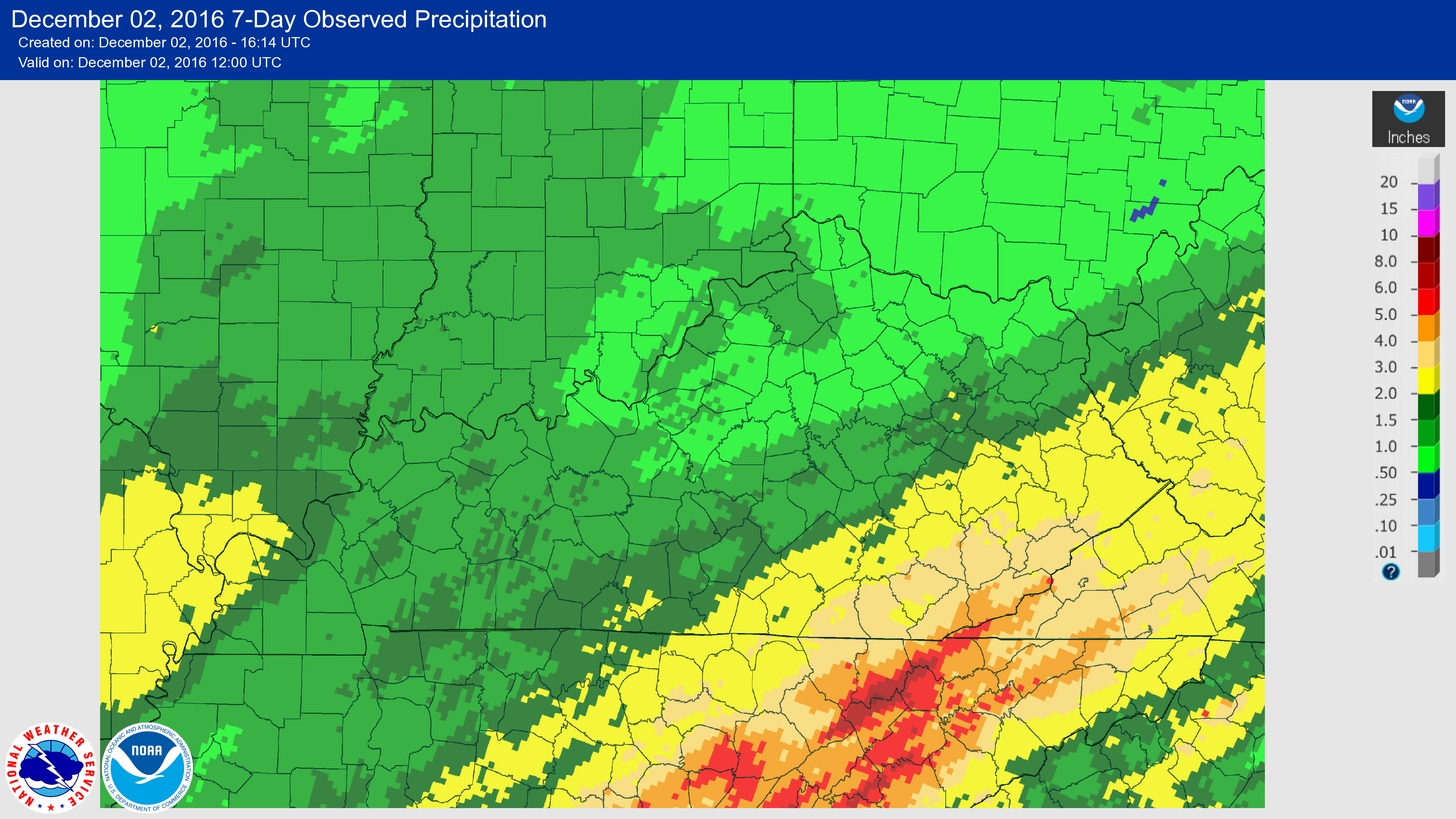
The Commonwealth finally saw some significant rainfall this past week. Figure 1 shows the 7 day observed precipitation with the majority of the state seeing over an inch. Portions of the state in an 'Extreme' drought recieved 2 to 3+ inches. Saying that, long term deficits are still quite high. Data at the Ag Weather Center shows the state is still nearly 2 inches below normal over the past 30 days and over 4 inches through the past 60. This week's update to the US Drought Monitor (Figure 2) remained nearly the same with a slight improvement in the Purchase area of Western Kentucky and expansion of 'Extreme' drought a bit farther northeast in Eastern Kentucky. This map does not take into account the rainfall on the 30th and much of the 29th as the US Drought Monitor has a cutoff earlier in the week and is based on data only through 7 a.m. EST on the preceding Tuesday.
|
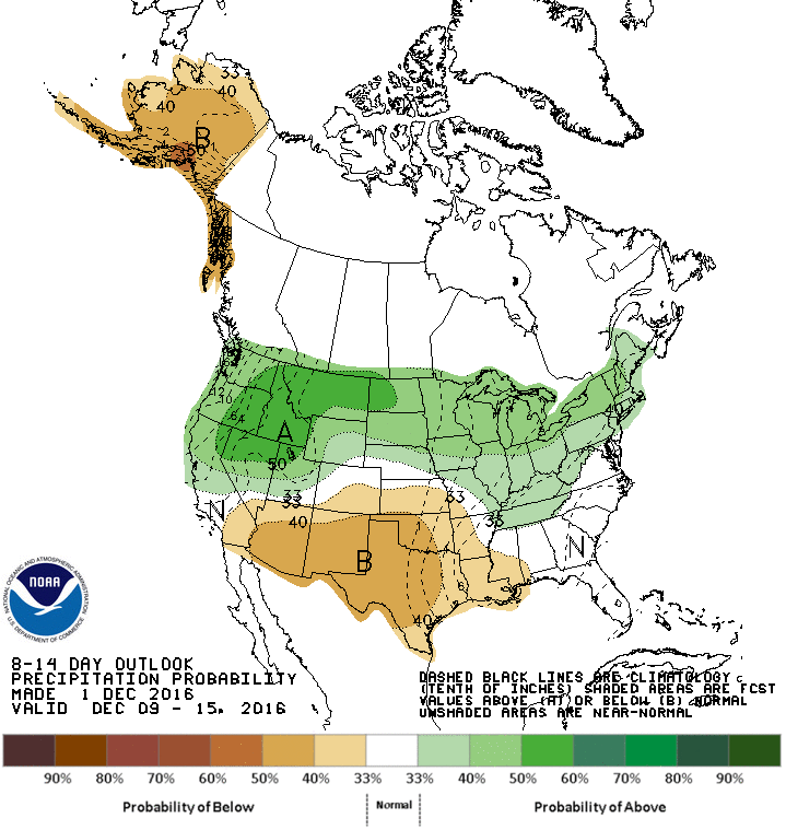
The forecast continues to point toward a wetter trend in coming weeks. Only expecting light precipitation accumulations Saturday night and Sunday, but more significant totals next work week as the state remains in a rather unsettled pattern. Overall, looking at the potential for another inch or so in the upcoming week. The 8 to 14 day outlook (Figure 3), valid for December 9th through the 15th, keeps a better chance for above normal precipitation in the forecast. A more detailed look at the forecast for your own location can be found using the Point Ag Forecast.
|
|
11/29/2016 Drought Update:
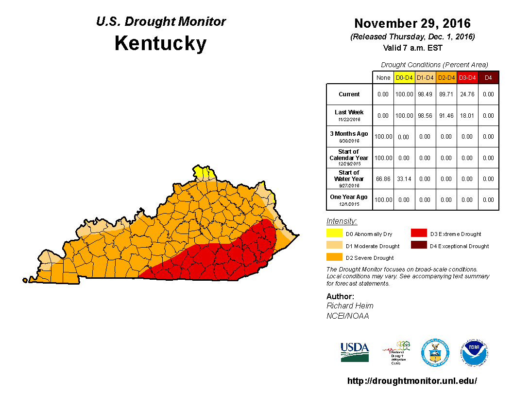
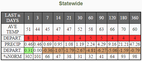
As of the latest update to the US Drought Monitor seen below (Figure 1), 18% (South-Central and Southeastern) of Kentucky is now in a 'Extreme' drought, while 'Severe' Drought remains across the majority of the remaining area. Based on the table below (Figure 2)(valid 11/29), the state is over 2.5 inches below normal over the past 30 days and that number increases to nearly 5 inches over the past 60 days. Saying that, the weather pattern seems to be shifting. Western Kentucky averaged over an inch of rainfall on the 28th. Central Kentucky and the Bluegrass Region both averaged over a quarter inch, while Eastern Kentucky didn't see much of anything.

|
|
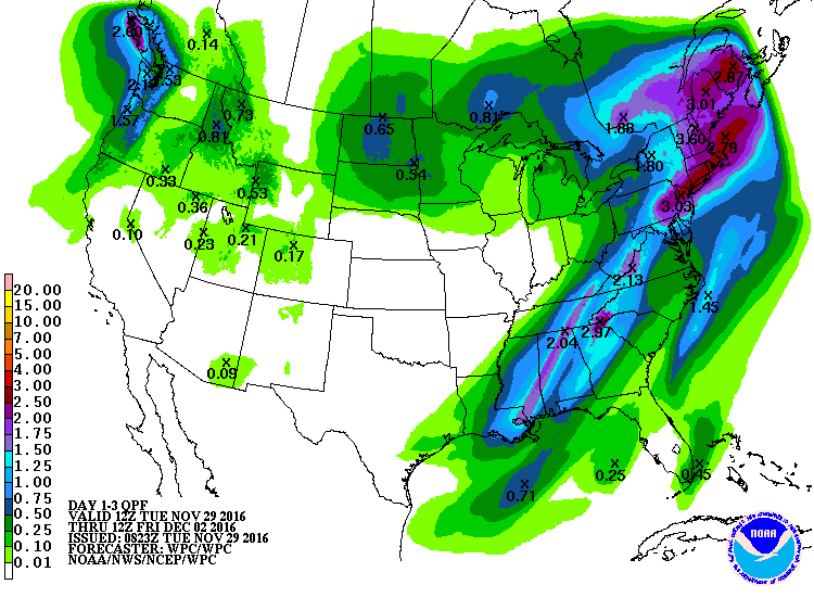
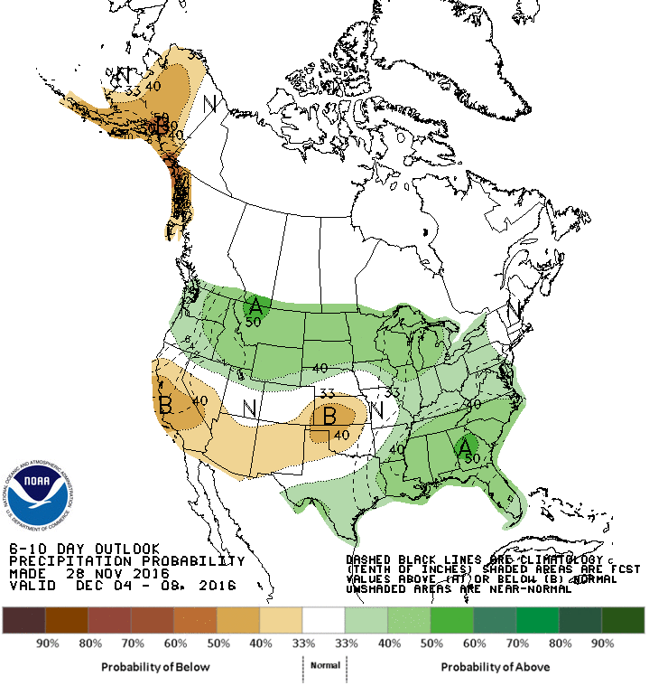
With that said, the forecast remains promising with a secondary round of showers and storms this evening (11/29) and lasting into tomorrow (11/30). Below (Figure 3) is a look at the forecast rainfall over that time period with an inch+ in the forecast for portions of Eastern Kentucky. The 6 to 10 day outlook (Figure 4) does point to a better chance for above normal precipitation into the start of December.
|
|
While any rainfall is beneficial, data from the Long Term Palmer Drought Severity Index suggests that it will take 6 to 9 inches of precipitation to pull Eastern Kentucky out of drought. Western Kentucky and the Bluegrass Region are in the 3 to 6 inch range. The last Kentucky Crop Condition and Progress Report for the season came out on Monday (11/28). Just as in weeks past, it continues to point toward germination problems related to winter wheat and cover crops, along with farm ponds drying up and associated water issues. With pasture conditions so dry, many producers began feeding hay well ahead of schedule. On November 10th, a Level I drought declaration was issued for 117 counties in Kentucky.
* The weather data above is provided by the Kentucky Mesonet at Western Kentucky University and the National Weather Service.

