Welcome to the 51st National Farm Machinery Show
UK Agricultural Weather
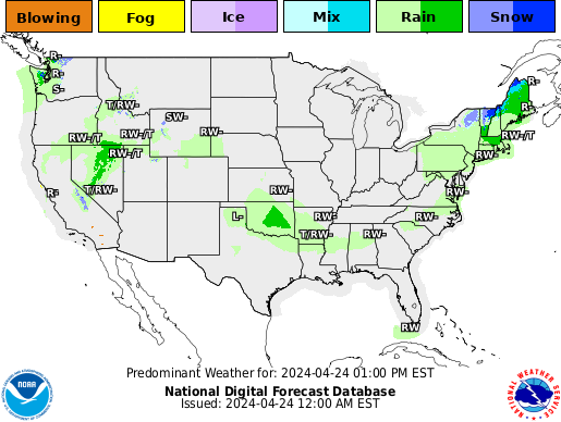
Today's NWS National Forecast Maps

The UK PointAgCast is available for Kentucky and the entire nation here!
The entire nation County-by-County here!
click for West, Central or East for the 7-day text forecast. Or next 48 hrs here.
Click here to see the forecast locations for rain, snow and a winter mix in Kentucky.
Click here to see the forecast temperatures for Kentucky.
Current Agricultural Weather Conditions in Kentucky
Based on observations at 600pm EDT, Thursday April 25, 2024
Across Kentucky...temperatures are near 67 degrees west, near 63 degrees central, and near 67 degrees east. Current sky conditions are cloudy west, sunny central, and sunny east. In the west, relative humidity is near 31%, and the dew point is near 36 degrees. In the central part of the state, relative humidity is near 39%, and the dew point is near 38 degrees. In the east, relative humidity is near 28%, and the dew point is near 33 degrees. Current drying conditions are good west, good central, and very good east. Winds are from the east at 7 mph west, where conditions are favorable for spraying. Winds are from the north at 8 mph central, where conditions are favorable for spraying. Winds are variable at 5 mph east, where conditions are favorable for spraying. Based on current available observations, the highest temperature is 70 degrees at Bowling Green. The lowest temperature is 60 degrees at Covington.
Click here
Updated Thursday Evening, December 9, 2021

Severe weather on the table
It has been a rather active weather pattern to start December. Through the 8th, the
state has averaged 1.39 inches. Attention now turns to another round of showers and
storms tomorrow and Saturday. Altogether, another half to 1.5 inches will be on the
table. Coverage will start tomorrow scattered in nature. Highs will jump into the 60s
across much of the area behind breezy southerly winds. Shower/storm coverage and
intensity then increases tomorrow night and into Saturday morning. A line of storms is expected with damaging
winds as the main threat, but tornadoes also very much possible. Heavy rain also presents
a flooding threat, especially for low lying areas. Now is the time to get animals out
of those spots. Bottom line, this will present an overnight threat, so please have
a way to get warning (highly suggest a NOAA Weather Radio).
After a brief cool down for the latter half of the weekend, temperatures go on the uphill
climb next week. Outlooks hint the warm air will hang around the area through the third
full week of December. Any additional rain chances look to hold off until late workweek.
The UK PointAgCast is available for Kentucky and the entire nation here!
The entire nation here!
click for West, Central or East for the 7-day text forecast. Or next 48 hrs here.
Click here to see the forecast locations for rain, snow and a winter mix in Kentucky.
Click here to see the forecast temperatures for Kentucky.
ILL:

|
IND:

|
US:
|
Western KY:
|
Central KY:

|
Eastern KY:
|
 Across the Commonwealth for the next week...
Kentucky Medium & Long Range Outlook:
                             KENTUCKY
                 ---------------------------------------------
                 6 TO 10 DAY  8 TO 14 DAY   30 DAY    90 DAY
                 MAY 1-MAY 5  MAY 3-MAY 9    JUN       JUN-AUG
                 -----------  -----------  --------  ---------
   Temperature:      Above        Above
 Precipitation:     Normal       Normal

....  Medium and long range outlooks provided by NCEP/K. Thomas Priddy


Click here for the outlook maps.
2
�
Temperature
LMK
030
FXUS63 KLMK 251933
AFDLMK

Area Forecast Discussion
National Weather Service Louisville KY
333 PM EDT Thu Apr 25 2024

.KEY MESSAGES...

*   A few rain showers are possible on Friday, with light
    precipitation totals (less than 0.10") generally expected. A
    stray thunderstorm cannot be ruled out Friday afternoon.

*   Warm and breezy this weekend, with gusts exceeding 30 mph out of
    the southwest at times.

*   Rain chances return early next week, but above normal
    temperatures persist.

&&

.SHORT TERM /THROUGH FRIDAY/...
Issued at 333 PM EDT Thu Apr 25 2024

Quiet weather continues across the region this afternoon with mostly
sunny skies present across much of the Ohio Valley. Latest visible
satellite imagery shows convective debris cirrus streaming across
southwestern IN and western KY, with this area of high clouds
expected to gradually push eastward later this afternoon as
convection continues across the central Plains. Surface high
pressure currently located over southern Ontario continues to allow
dry northeast low-level flow into central KY and southern IN, and
this has also resulted in a fairly noticeable north-south gradient
in temperatures this afternoon. As we head toward sunset tonight,
expected increasingly filtered sunshine, especially west of I-65,
with dry and quiet weather continuing through the evening hours.

Tonight, dry weather is expected to continue across much of the
area, with the sfc-850 mb layer remaining fairly dry below
increasing mid-level moisture. Would expect skies to be clear enough
and winds to remain light enough for another decent radiational
cooling setup across portions of southern IN and the KY Bluegrass,
though temperatures are generally expected to be warmer tonight
compared to last night and this morning. By the pre-dawn hours
Friday, a deeper fetch of moisture will start to enter southwestern
portions of the CWA as a warm front begins to lift through the
region. While initial radar returns will likely evaporate within the
dry low-levels, a chance of showers is expected across the Pennyrile
by around sunrise tomorrow.

Tomorrow, increased cloud cover and a few rain showers are expected
as the aforementioned warm front lifts across the region. By no
means will Friday be a washout, as precipitation chances should
remain fairly confined to the zone of deepest moisture and
isentropic lifting in the vicinity of the front. Temperatures will
generally be warmer on Friday, with temporarily reduced temperatures
expected in the vicinity of the front where there should be greater
cloud cover. Highs tomorrow should be in the 70s in most locations,
although a few 80 degree readings would be most likely across
southern and SW Kentucky. Initially, precipitation chances should be
forced by broad lifting along the warm front, though increased
instability behind the warm front means that an isolated rumble of
thunder cannot be ruled out tomorrow afternoon, though severe
impacts are not expected.

&&

.LONG TERM /FRIDAY NIGHT THROUGH THURSDAY/...
Issued at 333 PM EDT Thu Apr 25 2024

Friday Night through Sunday Night...

Warm front lifting northward will take most of its precip solidly
north of the Ohio River. Still some uncertainty in the timing and an
outside chance that we see isolated convection to the south of the
warm front. Therefore will hold on to a 20% chance,

The balance of the weekend will be warm and breezy, with temps more
in line with late May or early June. The main summer component that
will be missing is humidity, as dewpoints stay in the mid/upper 50s.
and a subsidence layer from 850-700mb will keep a lid on any
convection. Tight pressure gradient will yield breezy conditions,
with S-SW winds at a solid 15-20 mph with gusts around 30 mph each
afternoon.

Weakening cold front starts to advance from the Plains Sunday night,
but will only bring a slight chance for showers and storms into
areas west of I-65 in the pre-dawn hours of Monday.

Monday through Wednesday...

Early next week, the pattern will deamplify as the deep upper low
over the Plains lifts into Canada and the southeastern CONUS ridging
starts to break down. This will allow a cold front to drop SE into
the Ohio Valley, brining a good chance for showers with a few
embedded thunderstorms. Weak lapse rates and weakening shear will
work against severe potential, and organized convection in general.
Tue/Wed won't be quite as warm as this weekend, but still above
normal for late April. Model consensus still yields rain chances
throughout the period, but expect that to come into better focus as
we get closer in time. The best chance for a dry day still appears
to be Tuesday, and even if it does rain each day it should not be a
washout.

&&

.AVIATION /18Z TAFS THROUGH 00Z SATURDAY/...
Issued at 1253 PM EDT Thu Apr 25 2024

VFR conditions expected through the forecast period. Clouds will
increase late in the period as a warm front begins to lift into the
region. Some scattered rain showers may also develop toward the end
of the forecast period as well ahead of the frontal boundary.

&&

.LMK WATCHES/WARNINGS/ADVISORIES...
KY...None.
IN...None.

&&

$$

SHORT TERM...CSG
LONG TERM...RAS
AVIATION...DM


