| ||||||
UKAWC: NEW weather pages here... A joint service of the UK Ag Weather Center and the National Weather Service. Regional Hourly Observations For CARROL County, Kentucky Issued at 400 PM EDT WED APR 17 2024 NORTHEAST KENTUCKY CITY SKY/WX TMP DP RH WIND PRES REMARKS LEXINGTON PTSUNNY 78 62 57 SW28G38 29.86F COVINGTON PTSUNNY 77 59 53 SW17G35 29.76F FRANKFORT PTSUNNY 80 60 50 SW23G33 29.83S
Current Agriculture, Lawn & Garden Weather Conditions in Kentucky Based on observations at 400pm EDT, Wednesday April 17, 2024 Across Kentucky...temperatures are near 83 degrees west, near 78 degrees central, and near 74 degrees east. Current sky conditions are sunny west, partly sunny central, and partly sunny east. In the west, relative humidity is near 34%, and the dew point is near 52 degrees. In the central part of the state, relative humidity is near 57%, and the dew point is near 62 degrees. In the east, relative humidity is near 57%, and the dew point is near 58 degrees. Current drying conditions are good west, fair central, and fair east. Winds are variable at 7 mph with gusts at 24 mph west, where conditions are not favorable for spraying due to strong winds. Winds are from the southwest at 28 mph with gusts at 38 mph central, where conditions are not favorable for spraying due to strong winds. Winds are from the south at 7 mph east, where conditions are favorable for spraying. Based on current available observations, the highest temperature is 84 degrees at Louisville International. The lowest temperature is 72 degrees at London.
Radar: NWS Radar (NEW!), Bowling Green, KY Regional Radar, Hazardous Weather Outlook For CARROL County, Kentucky 1053 AM EDT Wed Apr 17 2024 DAY ONE This afternoon and tonight. Breezy south winds will gust to around 40 mph at times this afternoon. DAYS TWO THROUGH SEVEN Thursday through Tuesday. Another round of showers and storms is likely late Thursday evening. A few strong to severe storms will be possible, with gusty to damaging winds being the primary threat. SPOTTER INFORMATION STATEMENT Spotter activation may be needed late Thursday evening.
7-Day Forecast For CARROL County, KY 332 PM EDT Wed Apr 17 2024 TONIGHT Clear. A slight chance of showers this evening. Lows in the lower 50s. West winds 10 to 15 mph with gusts up to 30 mph, diminishing to around 5 mph after midnight. Chance of rain 20 percent. THURSDAY Mostly sunny. Unseasonably warm with highs around 80. South winds 5 to 10 mph. THURSDAY NIGHT Showers with a chance of thunderstorms. Lows in the upper 50s. South winds 5 to 10 mph, becoming southwest after midnight. Chance of rain 90 percent. FRIDAY Mostly cloudy with showers likely with a chance of thunderstorms in the morning, then partly cloudy with a slight chance of showers in the afternoon. Cooler with highs in the mid 60s. Northwest winds 5 to 10 mph with gusts up to 20 mph. Chance of rain 70 percent. FRIDAY NIGHT Partly cloudy. Lows in the mid 40s. North winds 5 to 10 mph. SATURDAY Partly cloudy. Highs in the lower 60s. SATURDAY NIGHT Partly cloudy. Lows in the upper 30s. SUNDAY Partly cloudy. Highs in the upper 50s. SUNDAY NIGHT Partly cloudy in the evening, then clearing. Lows in the upper 30s. MONDAY Mostly sunny. Highs in the lower 60s. MONDAY NIGHT Mostly clear in the evening, then becoming partly cloudy. Lows in the lower 40s. TUESDAY Partly cloudy. A chance of showers in the afternoon. Highs in the upper 60s. Chance of rain 40 percent. TUESDAY NIGHT Partly cloudy with a chance of showers. Lows in the upper 40s. Chance of rain 40 percent. WEDNESDAY Mostly sunny. Highs in the upper 60s.
Medium & Long Range Outlook For CARROL County, Kentucky
                             KENTUCKY
                 ---------------------------------------------
                 6 TO 10 DAY  8 TO 14 DAY   30 DAY    90 DAY
                   APR 23-27 APR 25-MAY 1    JUN       JUN-AUG
                 -----------  -----------  --------  ---------
   Temperature:
 Precipitation:

....  Medium and long range outlooks provided by NCEP/K. Thomas Priddy
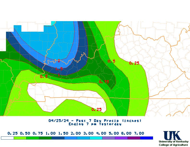
Kentucky Climate Summary Kentucky Climate Summary For the Period 04-10-2024 to 04-16-2024 Temperatures for the period averaged 64 degrees across the state which was 8 degrees warmer than normal and 14 degrees warmer than the previous period. High temperatures averaged from 75 in the West to 74 in the East. Departure from normal high temperatures ranged from 6 degrees warmer than normal in the West to 6 degrees warmer than normal in the East. Low temperatures averaged from 55 degrees in the West to 52 degrees in the East. Departure from normal low temperature ranged from 9 degrees warmer than normal in the West to 11 degrees warmer than normal in the East. The extreme high temperature for the period was 89 degrees at KOOMER RIDGE and the extreme low was 34 degrees at BURKESVILLE 3W.Precipitation (liq. equ.) for the period totaled 1.50 inches statewide which was 0.41 inches above normal and 138% of normal. Precipitation totals by climate division, West 1.33 inches, Central 1.36 inches, Bluegrass 1.98 inches and East 1.32 inches, which was 0.16, 0.25, 0.94 and 0.29 inches above normal. By station, precipitation totals ranged from a low of 0.44 inches at FRANKLIN 4SW to a high of 2.89 inches at FRANKFORT.
|


