| ||||||
UKAWC: NEW weather pages here... A joint service of the UK Ag Weather Center and the National Weather Service. Regional Hourly Observations For ADAIR County, Kentucky Issued at 700 PM EDT TUE MAY 07 2024 SOUTHEAST KENTUCKY CITY SKY/WX TMP DP RH WIND PRES REMARKS JACKSON PTSUNNY 74 69 85 S3 29.75F LONDON PTSUNNY 78 67 68 S8 29.75F SOMERSET PTSUNNY 81 68 65 SW7G17 29.71F MIDDLESBORO PTSUNNY 78 66 68 S9 29.79F MONTICELLO PTSUNNY 77 70 79 SW9 29.76F
Current Agriculture, Lawn & Garden Weather Conditions in Kentucky Based on observations at 700pm EDT, Tuesday May 07, 2024 Across Kentucky...temperatures are near 83 degrees west, near 79 degrees central, and near 74 degrees east. Current sky conditions are sunny west, partly sunny central, and partly sunny east. In the west, relative humidity is near 64%, and the dew point is near 70 degrees. In the central part of the state, relative humidity is near 71%, and the dew point is near 69 degrees. In the east, relative humidity is near 85%, and the dew point is near 69 degrees. Current drying conditions are fair west, fair central, and poor east. The livestock heat stress category is no stress west, no stress central, and no stress east. Winds are variable at 7 mph west, where conditions are favorable for spraying. Winds are from the southwest at 17 mph with gusts at 24 mph central, where conditions are not favorable for spraying due to strong winds. Winds are from the south at 3 mph east, where conditions are favorable for spraying. Based on current available observations, the highest temperature is 83 degrees at Paducah. The lowest temperature is 74 degrees at Jackson.
Radar: NWS Radar (NEW!), Bowling Green, KY Regional Radar, Hazardous Weather Outlook For ADAIR County, Kentucky 454 PM EDT Tue May 7 2024 /354 PM CDT Tue May 7 2024/ DAY ONE Tonight. Scattered strong to severe storms are possible this evening. The peak hours for the highest chance of severe weather look to be 8pm- midnight EDT, especially in southern Indiana and north central Kentucky. Damaging straight line wind gusts, large hail, and tornadoes will be possible. There is a small chance of local flooding problems in spots that receive repeated bouts of heavier storms. DAYS TWO THROUGH SEVEN Wednesday through Monday. There is the potential for a significant severe weather event Wednesday afternoon into early Thursday morning. Damaging winds, very large hail, and tornadoes will be possible during this timeframe. Local flooding will also be a concern, especially in southern Kentucky. SPOTTER INFORMATION STATEMENT Spotter activation is requested through Wednesday night as waves of storms move through the region. Remember to stay safe when spotting! Seek shelter if severe weather approaches your location! GENERAL STORM MOTION OF THE DAY: Storms this evening will move to the northeast at 40 to 45 mph. Any users of this storm motion must be aware that thunderstorm activity can be erratic and constantly evolving. Please use this with caution and be prepared for changing conditions.
7-Day Forecast For ADAIR County, KY 346 PM CDT Tue May 7 2024 TONIGHT Mostly cloudy. Chance of thunderstorms through the night. Showers likely after midnight. Lows in the mid 60s. Southwest winds 5 to 15 mph. Chance of precipitation 70 percent. WEDNESDAY Partly sunny. Chance of thunderstorms in the morning, then thunderstorms likely in the afternoon. Highs in the lower 80s. Southwest winds 5 to 10 mph. Chance of thunderstorms 70 percent. WEDNESDAY NIGHT Showers with thunderstorms likely in the evening, then showers and thunderstorms likely after midnight. Locally heavy rainfall possible after midnight. Lows in the mid 60s. Southwest winds 10 to 15 mph. Chance of precipitation 90 percent. THURSDAY Mostly cloudy with chance of thunderstorms in the morning, then mostly sunny with slight chance of thunderstorms in the afternoon. Highs in the upper 70s. Southwest winds 10 to 15 mph. Chance of thunderstorms 50 percent. THURSDAY NIGHT Cooler. Partly cloudy. Slight chance of thunderstorms in the evening, then slight chance of rain showers after midnight. Lows in the lower 50s. Northwest winds 5 to 15 mph. Chance of precipitation 20 percent. FRIDAY Cooler. Mostly sunny. Slight chance of rain showers in the morning, then slight chance of thunderstorms in the afternoon. Highs in the mid 60s. Chance of precipitation 20 percent. FRIDAY NIGHT Mostly clear. A 20 percent chance of thunderstorms in the evening. Lows in the upper 40s. SATURDAY Sunny. Slight chance of rain showers in the morning, then chance of rain showers and slight chance of thunderstorms in the afternoon. Highs around 70. Chance of precipitation 30 percent. SATURDAY NIGHT Mostly clear. Chance of rain showers and slight chance of thunderstorms in the evening. Lows in the upper 40s. Chance of precipitation 30 percent. SUNDAY Sunny. Highs in the lower 70s. SUNDAY NIGHT Mostly clear. Lows in the lower 50s. MONDAY Mostly sunny. A 20 percent chance of thunderstorms in the afternoon. Highs in the upper 70s. MONDAY NIGHT Partly cloudy with a 20 percent chance of thunderstorms. Lows in the mid 50s. TUESDAY Mostly sunny. Slight chance of thunderstorms in the morning, then chance of thunderstorms in the afternoon. Highs in the upper 70s. Chance of thunderstorms 30 percent.
Medium & Long Range Outlook For ADAIR County, Kentucky
                             KENTUCKY
                 ---------------------------------------------
                 6 TO 10 DAY  8 TO 14 DAY   30 DAY    90 DAY
                   MAY 13-17    MAY 15-21    JUN       JUN-AUG
                 -----------  -----------  --------  ---------
   Temperature:      Above        Above
 Precipitation:      Above        Above

....  Medium and long range outlooks provided by NCEP/K. Thomas Priddy
Drought Status For ADAIR County, Kentucky (Based on the latest Palmer Drought Severity and Crop Moisture Indices) CENTRAL KY CLIMATE DIVISION Hydrological Drought (PDSI) Situation: ------------------------------------------------------------------------------------ Current Long-term Hydrological Moisture Status: NEAR NORMAL (PDSI= 1.08) Rainfall Needed: 0.00 inches ABOVE NORMAL Crop Moisture (CMI) Situation: ---------------------------------------------------------------------------------------------------------- Current Short-term Crop Moisture Status: Favorable For Normal Growth And Fieldwork (CMI= 0.56) Change From Previous Week: DRIER SOILS ( -0.49) Note: Due to rainfall variability within each climate division, check Precip Reports/GIS Estimates and the Kentucky Climate Summary for the latest moisture information for this county.
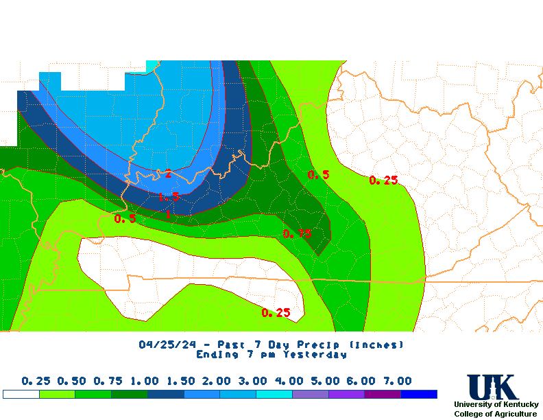
Kentucky Climate Summary Kentucky Climate Summary For the Period 04-30-2024 to 05-06-2024 Temperatures for the period averaged 70 degrees across the state which was 8 degrees warmer than normal and 8 degrees warmer than the previous period. High temperatures averaged from 79 in the West to 78 in the East. Departure from normal high temperatures ranged from 4 degrees warmer than normal in the West to 4 degrees warmer than normal in the East. Low temperatures averaged from 61 degrees in the West to 59 degrees in the East. Departure from normal low temperature ranged from 8 degrees warmer than normal in the West to 11 degrees warmer than normal in the East. The extreme high temperature for the period was 91 degrees at PEABODY and the extreme low was 48 degrees at MOREHEAD 4NE.Precipitation (liq. equ.) for the period totaled 1.93 inches statewide which was 0.69 inches above normal and 155% of normal. Precipitation totals by climate division, West 1.72 inches, Central 2.89 inches, Bluegrass 1.51 inches and East 1.60 inches, which was 0.39, 1.56, 0.29 and 0.5 inches above normal. By station, precipitation totals ranged from a low of 0.50 inches at MT STERLING AWOS to a high of 4.19 inches at EDMONTON 5W.
|


