Weather and Climate Synopsis
|
|
County, Illinois Weather and Climate Synopsis |

[National] [International] [Learning] [EWOCK] [Reg Clim Ctrs] |
(Click image to zoom) or
Click Here
Satellite images from NOAA
Also see NWS Watch/Warning Maps |
A joint service of the UK Ag Weather Center and the National Weather Service.
Synopsis...

A SURFACE LOW PRESSURE SYSTEM WAS ACROSS THE NORTHERN GREAT LAKES
AND PROVIDED MOSTLY CLOUDY SKIES OVERNIGHT AND INTO MONDAY MORNING.
EARLY MORNING LOW TEMPERATURES RANGED MAINLY FROM 45 TO 50
DEGREES ACROSS THE REGION.

COOLER TEMPERATURES WERE ACROSS ILLINOIS WITH MORNING. TEMPERATURES
WERE SLOWLY CLIMBING INTO THE UPPER 40S ACROSS NORTH CENTRAL
ILLINOIS. WITH SOME PATCHY SUN...TEMPERATURES CLIMBING INTO THE UPPER
50S ACROSS FAR SOUTHEAST ILLINOIS.  SCATTERED LIGHT RAIN HAD
DEVELOPED ACROSS PARTS OF NORTH CENTRAL ILLINOIS.

AS LOW PRESSURE IS ACROSS THE NORTHERN GREAT LAKES TODAY...MOSTLY
CLOUDY SKIES AND SCATTERED LIGHT RAIN CAN BE EXPECTED.
HIGH TEMPERATURES WILL RANGE FROM THE LOWER 50S ACROSS NORTH
CENTRAL ILLINOIS TO THE LOWER 60S ACROSS SOUTHEAST ILLINOIS. AS THE
LOW PRESSURE MOVES NORTHEAST INTO SOUTHERN CANADA...EXPECT A DECREASE
IN CLOUDS THIS EVENING AND OVERNIGHT ACROSS CENTRAL AND SOUTHEAST
ILLINOIS.

$$
NORTHWEST ILLINOIS

CITY           SKY/WX    TMP DP  RH WIND       PRES   REMARKS
MOLINE         MOSUNNY   32  22  66 SW5       30.04F WCI  27 TC   0
![]() Current Temperatures, Dewpoint Map, RH, Wind, Regional Obs, Surface 4-Panel
Current Temperatures, Dewpoint Map, RH, Wind, Regional Obs, Surface 4-Panel
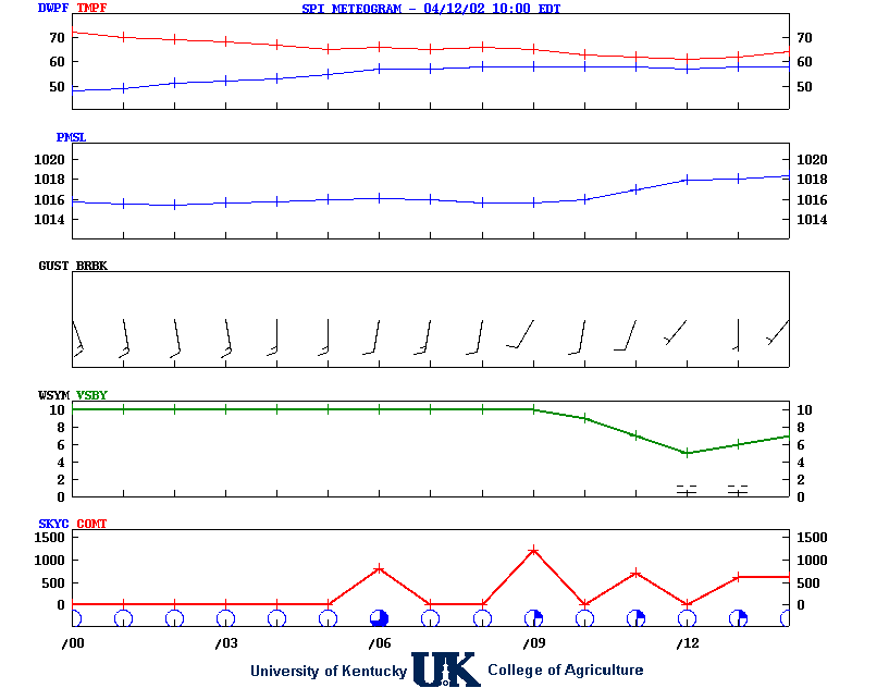
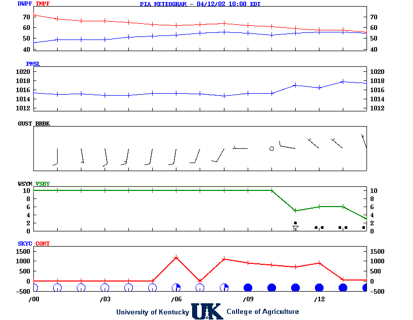
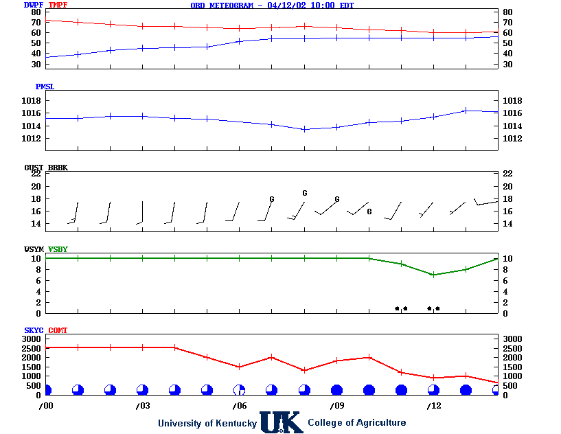
![]() Meteograms : Springfield , Peoria , Quad City , Chicago (O'Hare) , Rockford
Meteograms : Springfield , Peoria , Quad City , Chicago (O'Hare) , Rockford
.TODAY...Partly sunny this morning, then clearing. Not as cool
with highs around 40. South winds 5 to 10 mph.
.TONIGHT...Partly cloudy in the evening, then becoming mostly
cloudy. Not as cool with lows around 30. Southwest winds 5 to
10 mph with gusts up to 20 mph.
.MONDAY...Partly sunny. Highs in the upper 40s. Southwest winds
5 to 10 mph.
.MONDAY NIGHT...Mostly cloudy with a chance of rain in the
evening, then partly cloudy after midnight. Lows in the lower
30s. West winds around 5 mph. Chance of rain 40 percent.
.TUESDAY...Mostly sunny. Highs in the upper 40s. Northwest winds
around 5 mph.
.TUESDAY NIGHT...Partly cloudy in the evening, then mostly cloudy
with a chance of rain after midnight. Lows in the mid 30s. Chance
of rain 40 percent.
.WEDNESDAY...Mostly cloudy with a 50 percent chance of rain.
Highs in the mid 40s.
.WEDNESDAY NIGHT...Mostly cloudy. Lows in the lower 30s.
.THURSDAY...Mostly sunny. Highs in the mid 40s.
.THURSDAY NIGHT...Mostly clear. Lows in the upper 20s.
.FRIDAY...Mostly sunny. Highs around 50.
.FRIDAY NIGHT...Mostly cloudy in the evening, then becoming
partly cloudy. Lows in the lower 30s.
.SATURDAY...Mostly sunny. Highs in the lower 40s.
![]() 12-48 Hr Surface, 12-48 Hr ETA 500mb/Sfc, TWC Forecast, Fire Danger, Day 1 Precip, Day 2
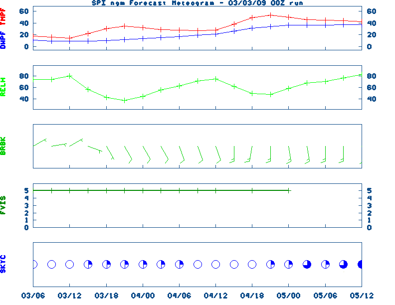
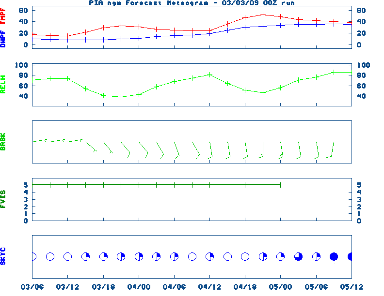
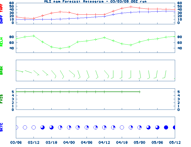
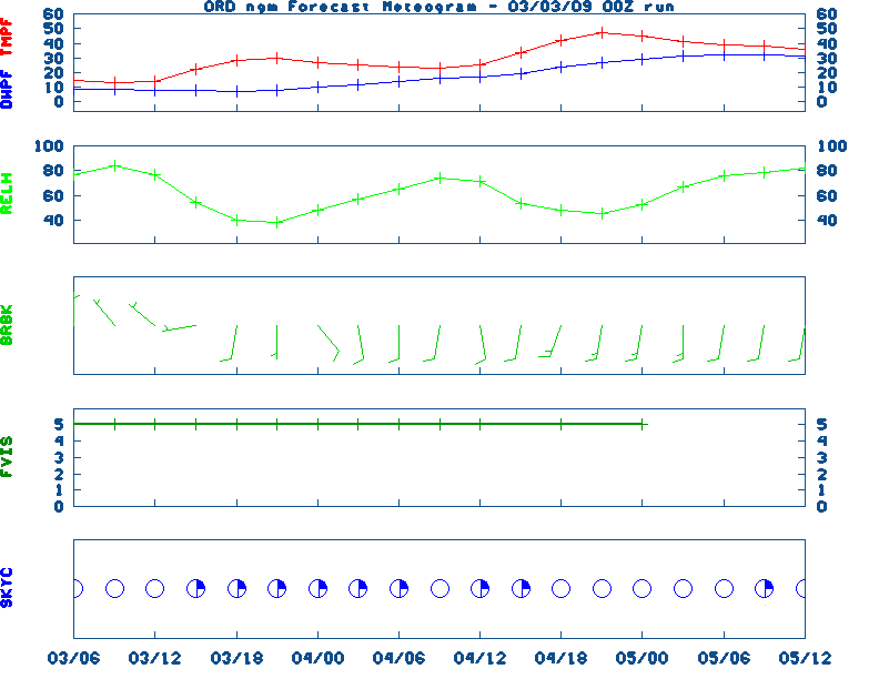
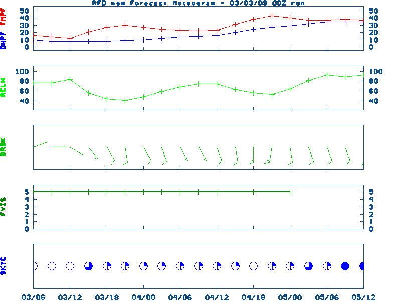
12-48 Hr Surface, 12-48 Hr ETA 500mb/Sfc, TWC Forecast, Fire Danger, Day 1 Precip, Day 2![]() NGM 60 Hr Forecast Meteograms : Springfield , Peoria , Quad City , Chicago (O'Hare) , Rockford ,
NGM 60 Hr Forecast Meteograms : Springfield , Peoria , Quad City , Chicago (O'Hare) , Rockford ,
                 6 TO 10 DAY  8 TO 14 DAY   30 DAY    90 DAY     120 DAY    180 DAY
                                           NOV05   NOV05-JAN06 DEC05-FEB06 FEB06-APR06
                 -----------  -----------  --------  ---------  ---------  ---------
   Temperature:      Below        Below      Above     Normal     Normal     Normal
 Precipitation:      Below        Below     Normal     Normal     Normal     Normal

....  Medium and long range outlooks provided by NCEP/K. Thomas Priddy
-----------------------------------------------------------------------
FEBRUARY 23RD...HISTORIC WEATHER EVENTS...WITH KENTUCKY HIGHLIGHS...
...1802...
A great snowstorm raged along the New England coast producing 48 inches
of snow north of Boston. Three large ships from Salem were wrecked
along Cape Cod. (David Ludlum)
...1936...
A severe blizzard in the Sierra Nevada Range closed Donner Pass. It
stranded 750 motorists and claimed seven lives. (David Ludlum)
---------- KENTUCKY CLIMATE HIGHLIGHTS ---------
...FEBRUARY 1899...
February.  "The month will go down in Kentucky history as 'the
cold February'.  From the 9th to the 14th was a period of
unprecedented cold; the temperature in many portions of the State
going to 20 to 30 degrees below zero," and to -33 degrees F at
Sandy Hook on 2/11/1899.  In at least one location, "the Kentucky
River, solidly frozen, was possible for team and wagon."
Priddy, UKAWC
...1996...
The mercury climbed to 79 degrees at the Jackson KY NWS Weather Office. This
reading represents the warmest February temperature ever recorded at the Jackson
Weather Office since climate records begin in 1981.
(NWS Jackson, KY)
|
|
|